It looks like you're using an Ad Blocker.
Please white-list or disable AboveTopSecret.com in your ad-blocking tool.
Thank you.
Some features of ATS will be disabled while you continue to use an ad-blocker.

The Faults That Ruptured in Twin California Quakes Are Very, Very Weird, Geologists Say
page: 1share:
Here's where things get interesting: The 7.1-magnitude earthquake rattled a fault within the Little Lake fault zone — cracks in this spot near Ridgecrest tend to run in the northwest-southeast direction.
"The earthquake on Thursday [July 4] was more complex. And part of that smaller event happened on an unmapped fault that trends NE-SW. This is very interesting geologically, said Michele Cooke, a geoscientist at the University of Massachusetts - Amherst. "We don't have a lot of earthquakes in our record that show simultaneous slip on two perpendicular faults."
The Faults That Ruptured in Twin California Quakes Are Very, Very Weird, Geologists Say
The recent quakes happened on perpendicular faults in a complicated zone. They were not what is expected when a plate slides by another. The short faults zig-zaged across each other at more than one point and this is not normal.
Michele Cooke a geoscientist said "We don't have a lot of earthquakes in our record that show simultaneous slip on two perpendicular faults." Complex rupturing like this can be dangerous. She also said "Without a doubt the earthquakes released stress on the fault. The more challenging question is whether these earthquakes loaded up nearby faults and whether 'enough' of the stress has been released."
US Military Cabal masquerading as Lex Luther..
on July 4th Independence day!
on July 4th Independence day!
a reply to: LookingAtMars
Thanks for posting this, I was hoping I wasn’t alone in my observations. I have never seen a pattern of swarming aftershocks that are so defined as this. I had been looking at the fault maps but nothing made sense.
From the article
Thanks for posting this, I was hoping I wasn’t alone in my observations. I have never seen a pattern of swarming aftershocks that are so defined as this. I had been looking at the fault maps but nothing made sense.
From the article
"This area does not fit the textbook picture of sides of a plate sliding past one another," and instead the relatively short faults criss-cross each other on more than one plane. (In fact, the 6.4-magnitude quake began at a depth of 6.6 miles, or 10.7 km, while the epicenter of the bigger quake was much deeper, some 10.6 miles, or 17 km, beneath the surfac
edit on 7-7-2019 by Observationalist because: Added link
a reply to: KansasGirl
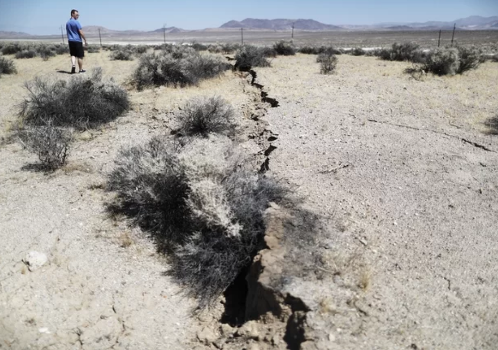
They look like tumbleweeds, which are very common around here, but I don't know why they look so black and gray in the picture.
They look like tumbleweeds, which are very common around here, but I don't know why they look so black and gray in the picture.
originally posted by: jeramie
a reply to: KansasGirl
They look like tumbleweeds, which are very common around here, but I don't know why they look so black and gray in the picture.
They look burned is that from the earthquake or......?
originally posted by: KansasGirl
In the picture, what's with the black and gray scrubs/shrubs?
The high contrast in the picture has exaggerated the shadows of sage/mesquite shrubs. Thinking the contrast was tweaked to better show the earthquake crack in the ground. Thus darkened all the shadows and over-lightened the highlights in the image.
Edit: though taking note of man's shadow, one can see the sun was probably high and direct so not necessary to tweak image...it is just naturally high contrasted due to natural lighting.
edit on 7 7 2019 by CynConcepts because: (no reason given)
a reply to: CynConcepts
I was gonna say the camera settings for the same reason you stated and also the harsh, around midday light. I bet you are right, they adjusted it with Photoshop.
I was gonna say the camera settings for the same reason you stated and also the harsh, around midday light. I bet you are right, they adjusted it with Photoshop.
This area is very close to a geothermal pumping site. They pump water into the hot magma which causes steam to run the turbines that make electric for
the area.
So, compare these 'peculiarly perpendicular faults' activities to 3 years ago in the same China Lake military weapons testing area:
newspunch.com...
Right angles can be explained as conjugal faults, as they are likely detonating in and/or affecting the same 1-2 areas afterall.
But RECTANGULAR distribution of aftershocks as if in a gridlike pattern? Perhaps its not just cannikin (alaska 9.2 military-made quake) but also has an aerial (ie, HAARP) component to the seismic testing.
Seems to me this is just a 2nd or more round of testing induced seismicity since at least 2016.. hence the pattern of symmetry.
Which could be stronger correlated if they isssue the diagram of aftershocks this time around that may reveal the rectangular grid formation of aftershocks, too.
From Wikipedia.
Coso Rock Art District
That is some well protected art. Sounds like a very cool place, art in the desert. Hope none of it was damaged by the EQ.
Coso Rock Art District, containing the Big and Little Petroglyph Canyons, is a rock art site containing over 100,000 Paleo-Indian and/or Native American Petroglyphs.[1] The Coso Range is between the Sierra Nevada and the Argus Range. Indian Wells Valley lies to the south of this location.
This north-south trending range of about 400 square miles (1,000 km2) consists of rhyolitic domes and outcrops of volcanic rock. Also known as Little Petroglyph Canyon and Sand Tanks, Renegade Canyon is but one of several major canyons in the Coso Range, each hosting thousands of petroglyphs (other locations include Haiwee Springs, Dead End Canyon, and Sheep Canyon).
The majority of the Coso Range images fall into one of six categories: bighorn sheep, entopic images, anthropomorphic or human-like figures (including animal-human figures known as pattern-bodied anthopomorphs), other animals, weapons & tools, and "medicine bag" images. Most of the Coso Range is on the Naval Air Weapons Station China Lake, where visitation is restricted, vandalism is low, and preservation is most likely.
"emphasis mine"
Coso Rock Art District
That is some well protected art. Sounds like a very cool place, art in the desert. Hope none of it was damaged by the EQ.
originally posted by: misskat1
This area is very close to a geothermal pumping site. They pump water into the hot magma which causes steam to run the turbines that make electric for the area.
I think there are lots of locations like this up the eastern sierra's. That area is basically all old volcano's. IDK if they are all dormant but there are tons of hot springs in the area and there are smallish towns along the sierra's that rely on geothermal for power generation and maybe heating as well.
I wonder if there have been any new installations in this area or expansions of existing locations.
originally posted by: misskat1
This area is very close to a geothermal pumping site. They pump water into the hot magma which causes steam to run the turbines that make electric for the area.
There is a chance that these earthquakes could have been remotely triggered by the geothermal plant.
Check out this Interesting study
Absence of remote earthquake triggering within the Coso and Salton Sea geothermal production fields
Abastract
Geothermal areas are long recognized to be susceptible to remote earthquake triggering, probably due to the high seismicity rates and presence of geothermal fluids. However, anthropogenic injection and extraction activity may alter the stress state and fluid flow within the geothermal fields.
Here we examine the remote triggering phenomena in the Coso geothermal field and its surrounding areas to assess possible anthropogenic effects. We find that triggered earthquakes are absent within the geothermal field but occur in the surrounding areas. Similar observation is also found in the Salton Sea geothermal field.
We hypothesize that continuous geothermal operation has eliminated any significant differential pore pressure between fractures inside the geothermal field through flushing geothermal precipitations and sediments out of clogged fractures. To test this hypothesis, we analyze the pore-pressure-driven earthquake swarms, and they are found to occur outside or on the periphery of the geothermal production field.
Therefore, our results suggest that the geothermal operation has changed the subsurface fracture network, and differential pore pressure is the primary controlling factor of remote triggering in geothermal fields.
If I could post images you could see how the geothermal field is void of seismic activity while areas like what we see now show lots of activity.
3.2. Study of Pore-Pressure-Driven Swarms
Our results confirm that areas in the vicinity of but outside the producing geothermal field are susceptible to remote triggering. Here, however, we have clearly established the absence of remote triggering inside the CGF production area. Before we attempt to estimate the stress state, we first test the second kind of remote triggering model.
Among the numerous fluid-related triggering models, the fracture unclogging model can be uniquely applied to geothermal fields in that the geothermal mineral precipitation and sediments lead to clogged fractures, which results in differential pore pressure within fracture network [Brodsky et al., 2003; Brodsky and Prejean, 2005].
This fracture unclogging model has also been used as one of the explanations to the absence of remote triggering in Japan [Harrington and Brodsky, 2006]. We hypothesize that the continuous injection and extraction of geothermal fluid within the reservoir can disturb the clogged fracture and flush the blockages from fractures, which prevents the formation of differential pore pressure, while the fractures in natural settings remain clogged.
edit on 7-7-2019 by Observationalist because: (no reason given)
a reply to: LookingAtMars
I asked essentially this very question in the 2019 Quake thread... didn't get an answer, so I kinda figured maybe I was seeing something that wasn't there. But this corroborates it.
I was looking at the land as a heterogenous mixture of various liquids... essentially changing time in my mind to be able to analyze the very slow. I do something similar with electronic circuits, changing time in my mind to analyze the very fast. It looks like there is an area just west of Ridgecrest that is much less viscous than the surrounding area, like a rock in a river of mud, if you will. The fault that runs through Ridgecrest is the result of this obstruction, and a second fault zone (this one doesn't look like a line but like a series of lines running parallel to each other) cuts off at about a right angle to the other side of the obstruction. For the two quakes to have happened more or less simultaneously, the entire land mass would have shifted in two different directions at essentially the same time. This would do two things: put an eccentric force down towards L.A. on the main fault line, and built a twisting pressure farther north.
What I do not know is how the major fault lines will react to these new pressures. I am admittedly not an earthquake guy. My extent of earthquake-specific knowledge can be summed up in "Don't go where the ground moves around."
I AM an analysis guy, and I do understand a little of fluid dynamics.
I'm probably using incorrect terminology here, but if someone who is an "earthquake guy" could help bring me up to speed a little on the terminology and event-specific details, I bet we could get a good idea of where pressure is likely building. It does sound to me like the experts are worried and withholding some information for "the public good." That's all good and all, but I prefer to have all available information even if I have to figure it out myself.
TheRedneck
a reply to: Observationalist
Good thing we have 4 billion years of geology to catch up on then.
Just because modern tectonics isnt aware doesn't mean its out of the ordinary. I know you were just making a aimilar observation so dont take my reply as snark.
Good thing we have 4 billion years of geology to catch up on then.
Just because modern tectonics isnt aware doesn't mean its out of the ordinary. I know you were just making a aimilar observation so dont take my reply as snark.
originally posted by: KansasGirl
In the picture, what's with the black and gray scrubs/shrubs?
I thought it was just discoloration due to light flooding/lighting conditions, but you can clearly see the darkest one right on the crack right up front, and just a bit further in the background, the blackest looking one in that group is the one right on the crack as well... i wonder if the crack veers to the right further back where that other especially dark one is located.
originally posted by: ownbestenemy
a reply to: Observationalist
Good thing we have 4 billion years of geology to catch up on then.
Just because modern tectonics isnt aware doesn't mean its out of the ordinary. I know you were just making a aimilar observation so dont take my reply as snark.
Until we DO have 4 billion years of geology recorded, these incidences are new to us and worth a closer look and there is nothing obtuse about the enthusiasm expressed. It is your comment in fact that comes off conceited, and ignorant.
a reply to: LookingAtMars
According to Jimstone they were unusual because they were nukes. He did not know why they used nukes.
According to Jimstone they were unusual because they were nukes. He did not know why they used nukes.
new topics
-
2024 Pigeon Forge Rod Run - On the Strip (Video made for you)
Automotive Discussion: 16 minutes ago -
Gaza Terrorists Attack US Humanitarian Pier During Construction
Middle East Issues: 42 minutes ago -
The functionality of boldening and italics is clunky and no post char limit warning?
ATS Freshman's Forum: 1 hours ago -
Meadows, Giuliani Among 11 Indicted in Arizona in Latest 2020 Election Subversion Case
Mainstream News: 2 hours ago -
Massachusetts Drag Queen Leads Young Kids in Free Palestine Chant
Social Issues and Civil Unrest: 2 hours ago -
Weinstein's conviction overturned
Mainstream News: 3 hours ago -
Supreme Court Oral Arguments 4.25.2024 - Are PRESIDENTS IMMUNE From Later Being Prosecuted.
Above Politics: 5 hours ago -
Krystalnacht on today's most elite Universities?
Social Issues and Civil Unrest: 5 hours ago -
Chris Christie Wishes Death Upon Trump and Ramaswamy
Politicians & People: 6 hours ago -
University of Texas Instantly Shuts Down Anti Israel Protests
Education and Media: 8 hours ago
top topics
-
Krystalnacht on today's most elite Universities?
Social Issues and Civil Unrest: 5 hours ago, 8 flags -
Weinstein's conviction overturned
Mainstream News: 3 hours ago, 6 flags -
Electrical tricks for saving money
Education and Media: 17 hours ago, 5 flags -
Supreme Court Oral Arguments 4.25.2024 - Are PRESIDENTS IMMUNE From Later Being Prosecuted.
Above Politics: 5 hours ago, 5 flags -
University of Texas Instantly Shuts Down Anti Israel Protests
Education and Media: 8 hours ago, 5 flags -
Meadows, Giuliani Among 11 Indicted in Arizona in Latest 2020 Election Subversion Case
Mainstream News: 2 hours ago, 4 flags -
Massachusetts Drag Queen Leads Young Kids in Free Palestine Chant
Social Issues and Civil Unrest: 2 hours ago, 3 flags -
Chris Christie Wishes Death Upon Trump and Ramaswamy
Politicians & People: 6 hours ago, 2 flags -
Any one suspicious of fever promotions events, major investor Goldman Sachs card only.
The Gray Area: 10 hours ago, 2 flags -
God's Righteousness is Greater than Our Wrath
Religion, Faith, And Theology: 14 hours ago, 1 flags
active topics
-
Candidate TRUMP Now Has Crazy Judge JUAN MERCHAN After Him - The Stormy Daniels Hush-Money Case.
Political Conspiracies • 770 • : xuenchen -
University of Texas Instantly Shuts Down Anti Israel Protests
Education and Media • 177 • : theatreboy -
The functionality of boldening and italics is clunky and no post char limit warning?
ATS Freshman's Forum • 8 • : grey580 -
Breaking Baltimore, ship brings down bridge, mass casualties
Other Current Events • 487 • : Threadbarer -
2024 Pigeon Forge Rod Run - On the Strip (Video made for you)
Automotive Discussion • 1 • : chiefsmom -
Gaza Terrorists Attack US Humanitarian Pier During Construction
Middle East Issues • 9 • : Asher47 -
Fossils in Greece Suggest Human Ancestors Evolved in Europe, Not Africa
Origins and Creationism • 84 • : whereislogic -
Ditching physical money
History • 21 • : SprocketUK -
Meadows, Giuliani Among 11 Indicted in Arizona in Latest 2020 Election Subversion Case
Mainstream News • 4 • : ElitePlebeian2 -
Is there a hole at the North Pole?
ATS Skunk Works • 38 • : Therealbeverage