It looks like you're using an Ad Blocker.
Please white-list or disable AboveTopSecret.com in your ad-blocking tool.
Thank you.
Some features of ATS will be disabled while you continue to use an ad-blocker.

Google Earth 37°24'05.7"N 116°52'04.1"W
page: 2share:
a reply to: mtnshredder
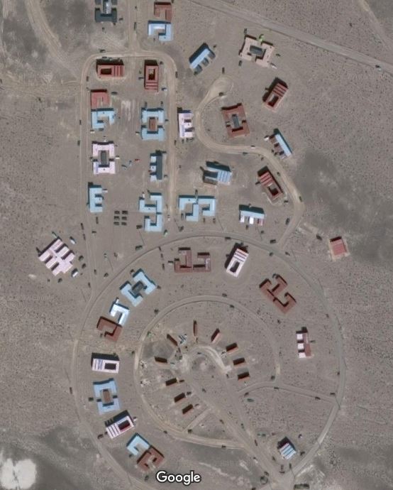
From what I have read about air to ground ranges, they tend to have the following.
A tank/armored target
A train on rails
A mock airstrip/hangar with mock aircraft
A small group of buildings
A marksmanship target
and simulated dug in positions for infantry.
In the picture I posted you can see most of those, the mock airstrip (with hangars and aircraft) is just south of what is in the picture.
a reply to: mtnshredder
They use shipping containers for buildings a lot and drop inert munitions through them so they can use the targeting pods and train with PGMs. There's one in Sweetwater that you can hear them using occasionally on the scanner. They'll call out "survivors" and targets of opportunity.
They use shipping containers for buildings a lot and drop inert munitions through them so they can use the targeting pods and train with PGMs. There's one in Sweetwater that you can hear them using occasionally on the scanner. They'll call out "survivors" and targets of opportunity.
a reply to: LookingAtMars
This is just a training site as Zaphod has pointed.
That star is there to help with accurate targeting.
The other structures are to help analyze the munition used. These structures are often replaced.
Check back on this location in a month or two and you will notice this.
This is just a training site as Zaphod has pointed.
That star is there to help with accurate targeting.
The other structures are to help analyze the munition used. These structures are often replaced.
Check back on this location in a month or two and you will notice this.
a reply to: Allaroundyou
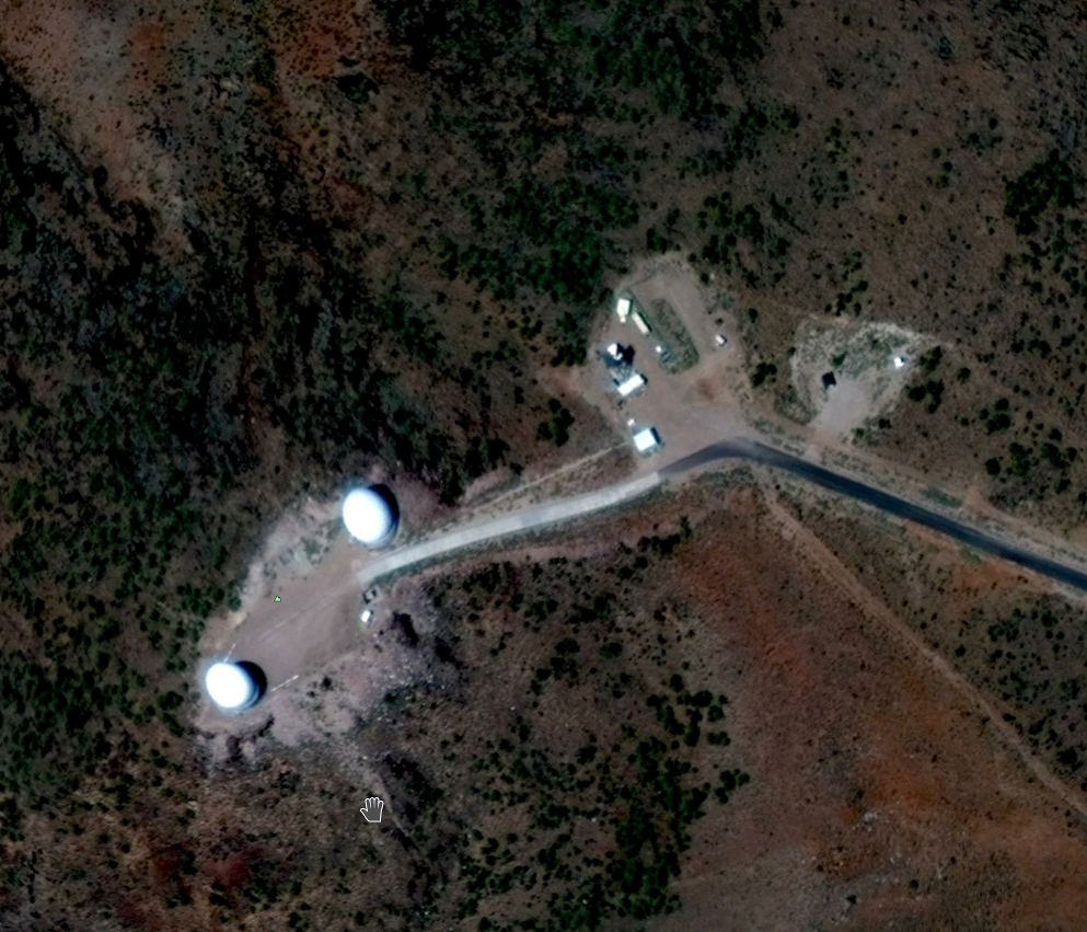
It's a standard layout with the command vehicle in the center, and the launchers around it. I can't be absolutely certain, but I'd say it is.
It's a standard layout with the command vehicle in the center, and the launchers around it. I can't be absolutely certain, but I'd say it is.
originally posted by: Zaphod58
a reply to: LookingAtMars
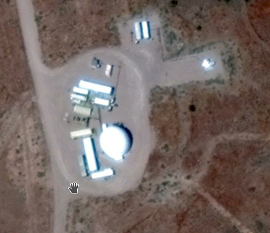
They're training areas. First is a SAM site, looks like a train, the bottom is an airfield.
I agree.
The US has a number of simulated SAM set ups for training purposes. This may be a SA-2 site that is simulated.
Nevermind, I see you already covered it.
edit on b000000312019-05-29T07:15:49-05:0007America/ChicagoWed, 29 May 2019 07:15:49 -0500700000019 by
butcherguy because: (no reason given)
a reply to: LookingAtMars
This is a bombing range. These are mock targets for practice. The last pic is a simulated air field.
This is a bombing range. These are mock targets for practice. The last pic is a simulated air field.
originally posted by: Zaphod58
a reply to: mtnshredder
They use shipping containers for buildings a lot and drop inert munitions through them so they can use the targeting pods and train with PGMs. There's one in Sweetwater that you can hear them using occasionally on the scanner. They'll call out "survivors" and targets of opportunity.
There was a cool video a few years ago I think of the B-2 dropping a bunch of inert bombs on a setup like this and showing how accurately it could hit, usually within a meter or two. I've been looking on YouTube but can't find it.
Yep, just the Nevada test and training range. Area 51 and nuclear tests were done in the area.
en.wikipedia.org...
en.wikipedia.org...
a reply to: LookingAtMars
Where was this internet post at ?
What was the subject content of the page it was posted on ?
I'm asking more questions b/c u pointed it out as if it were odd so I want to know more about the context of where it was posted.
leolady
An internet post had these coordinates in it with no explanation about what or why.
Where was this internet post at ?
What was the subject content of the page it was posted on ?
I'm asking more questions b/c u pointed it out as if it were odd so I want to know more about the context of where it was posted.
leolady
The first one is a mock SA-5 site, used for military training (RED FLAG, BLUE FLAG, etc.). The other ones are similar; used for air-to-ground and
ground-based combat training.
What look like train cars and buildings are actually CONEXes (shipping containers). They are a cheap and very durable way to simulate construction and vehicles. Easy to move around too.
CONEX 'buildings' at Fort McCoy Tactical Training Center, Fort McCoy, WI:
i.imgur.com...
What look like train cars and buildings are actually CONEXes (shipping containers). They are a cheap and very durable way to simulate construction and vehicles. Easy to move around too.
CONEX 'buildings' at Fort McCoy Tactical Training Center, Fort McCoy, WI:
i.imgur.com...
a reply to: TheTruthRocks
I knew it was an SA site, but several of them look similar so I wasn't sure which.
I knew it was an SA site, but several of them look similar so I wasn't sure which.
originally posted by: Gargoyle91
a reply to: LookingAtMars
I found that area awhile back turns out to be a training range .
Yeah for urban warfare etc
Thanks to everyone for all the insight. There are some really cool structures on that range. I found some radar pretty far away but don't think I was
all the way in NM. It made me think of Sunspot
a reply to: mtnshredder
At Pil Sung Range in ROK we had our range set up as Russian targets (late 80’s). We would have to go out on the range and put out forest fires from wayward munitions. Really crazy there.
Echo, India, Juliet band (IIRC) AA and Sam sites surrounding the range to thwart the inbound aircraft.
At Pil Sung Range in ROK we had our range set up as Russian targets (late 80’s). We would have to go out on the range and put out forest fires from wayward munitions. Really crazy there.
Echo, India, Juliet band (IIRC) AA and Sam sites surrounding the range to thwart the inbound aircraft.
edit on 9-6-2019 by PilSungMtnMan
because: (no reason given)
Just regarding the motivation for the original post, bearing in mind I have no idea what trygf is as mentioned...
But, the star is an sa5 as pointed out. This is currently in use in a live conflict zone in Syria. Certainly seems as if us personnel have been trained specifically with this emplacement in mind. Was the original poster drawing attention to it for this reason? I mean, I lost track about whether it is accepted us policy to have been bombing Syrian government installations or whether they were only supposed to be targeting daesh? Though of course training doesn't imply implementation in live theatre directly.
It's quite leap of both logic and presumption though... Just scratching around for a possible reason to draw attention to these coordinates.
a reply to: mersaultdies
There are several former Soviet missile systems still in use that have similar layouts. These have been out there for decades.
There are several former Soviet missile systems still in use that have similar layouts. These have been out there for decades.
new topics
-
Florida man's trip overseas ends in shock over $143,000 T-Mobile phone bill
Social Issues and Civil Unrest: 3 minutes ago -
Former Labour minister Frank Field dies aged 81
People: 2 hours ago -
SETI chief says US has no evidence for alien technology. 'And we never have'
Aliens and UFOs: 3 hours ago -
This is our Story
General Entertainment: 6 hours ago -
President BIDEN Vows to Make Americans Pay More Federal Taxes in 2025 - Political Suicide.
2024 Elections: 8 hours ago -
Ode to Artemis
General Chit Chat: 9 hours ago
top topics
-
University student disciplined after saying veganism is wrong and gender fluidity is stupid
Education and Media: 17 hours ago, 14 flags -
President BIDEN Vows to Make Americans Pay More Federal Taxes in 2025 - Political Suicide.
2024 Elections: 8 hours ago, 12 flags -
Should Biden Replace Harris With AOC On the 2024 Democrat Ticket?
2024 Elections: 15 hours ago, 6 flags -
One Flame Throwing Robot Dog for Christmas Please!
Weaponry: 13 hours ago, 6 flags -
Don't take advantage of people just because it seems easy it will backfire
Rant: 13 hours ago, 4 flags -
Ditching physical money
History: 13 hours ago, 4 flags -
SETI chief says US has no evidence for alien technology. 'And we never have'
Aliens and UFOs: 3 hours ago, 4 flags -
Former Labour minister Frank Field dies aged 81
People: 2 hours ago, 3 flags -
Ode to Artemis
General Chit Chat: 9 hours ago, 3 flags -
This is our Story
General Entertainment: 6 hours ago, 2 flags
active topics
-
University student disciplined after saying veganism is wrong and gender fluidity is stupid
Education and Media • 43 • : Consvoli -
Florida man's trip overseas ends in shock over $143,000 T-Mobile phone bill
Social Issues and Civil Unrest • 0 • : Consvoli -
So this is what Hamas considers 'freedom fighting' ...
War On Terrorism • 244 • : HopeForTheFuture -
"We're All Hamas" Heard at Columbia University Protests
Social Issues and Civil Unrest • 269 • : Vermilion -
Police clash with St George’s Day protesters at central London rally
Social Issues and Civil Unrest • 42 • : ohahhupthera -
Russia Ukraine Update Thread - part 3
World War Three • 5721 • : stu119 -
President BIDEN Vows to Make Americans Pay More Federal Taxes in 2025 - Political Suicide.
2024 Elections • 22 • : CarlLaFong -
Tucker Carlson UFOs are piloted by spiritual entities with bases under the ocean and the ground
Aliens and UFOs • 43 • : Xtrozero -
Thousands Of Young Ukrainian Men Trying To Flee The Country To Avoid Conscription And The War
Other Current Events • 127 • : Consvoli -
1980s Arcade
General Chit Chat • 25 • : confuzedcitizen