It looks like you're using an Ad Blocker.
Please white-list or disable AboveTopSecret.com in your ad-blocking tool.
Thank you.
Some features of ATS will be disabled while you continue to use an ad-blocker.

RAF Portreath/RRH Portreath, Cornwall, England
page: 16
share:
Thread note I'm doing this all on my phone so forgive me for any mistakes. Any information I'll be using will be copy and pasted from sites as I still
haven't worked out how to quote websites and texts. All info i post has been taken from Wikipedia
RAF Portreath or now known as Remote Radar Head (RRH) Portreath. Located on the north coast of Cornwall which is a county is the south west of England. I'll begin the thread by saying why I decided to create the thread. Almost 20 years me and my family always use to visit Cornwall for its scenery and surfing. My whole family were lovers of being in the sea whether it's surfing, diving, snorkelling or just plain swimming. We had always been a family who liked to explore from going into caves to driving down single track roads to just to see what was at the end. We had also been a family who enjoyed airshows so we're always excited if we ever came across military sites especially air fields.

Ok let's cut to the chase a bit. Bare in mind this was a time before smart phone or the ability to have information at our finger tips. So my mum especially was always interested in history so we were travelling around the Cornish coast looking for old tin mines, during the 1800s and early 1900s Cornwall was famous for its tin mining. So why following and looking at a map my mum mentioned that near our location was a disused airfield. Of course being interested in this we decided to see how close we could get and see what if anything was happening at the airfield. We drove down a few lanes looking to see if we can get close until we came up against a gated off entrance with a barrier with the typical warning signs you see at military sites


Now obviously we weren't stupid enough to try and gain access but we always took binoculars with us. So I remember when my mum and dad looked onto the site they saw people is those white paper overalls you see when people are working wth chemicals or substances. These people were working around a field full of crops. This was the time when GM crops were first starting to make the news so my parents never really thought nothing of it and just assumed it was a farm using a field to grow crops and were just protecting themselves from any chemicals being used. So having decided it wasn't that interesting we drove off and carried on exploring Cornwall
Doesn't sound exciting does it ? Fast forward to present day .. well today in fact. My dad moved to Cornwall my mum no longer with us (different story not really significant) and I'm down here visiting him. We took a drive out looking for some more ruins and generally exploring the coast. I was using my phone to look at different back routes to not so popular coastal areas. Using google maps I spotted RAF/RRH Portreath and just said to my dad 'oh there a disused airfield', even though the runway on google maps still looks in good condition. Anyway he told me the story which I've described above and he believed that the airfield I saw on google maps was the one we discovered years ago. So we ended up at the same gate in the picture above and got out to take a look. There's a newly built radar dome and me and my dad discussed it's probably for maritime as the coast is quite popular with shipping. There were still crops being grown though.
We got back in the car and while my dad drove, now having the technology at my finger tips I decided to google search the airfield which is where it became more interesting. I'm going to copy and paste some information.
Basic history of RAF Portreath:
Remote Radar Head Portreath or RRH Portreath is an air defence radar station operated by the Royal Air Force. It has a coastal location at Nancekuke Common, approximately 1.25 kilometres (0.78 mi) north east of the village of Portreath in Cornwall, England. Previously known as RAF Portreath, the station was built during 1940, opened in March 1941 and had a varied career during the Second World War, initially as a RAF Fighter Command station, from October 1941 as a ferry stop-over for aircraft bound to/from North Africa and the Middle East,[1] as a temporary stop-over for USAAF and RCAF units, and then as a Coastal Command station. By the end of the war, it had run down and in May 1950 was handed back to the government by the RAF.
Continued in a second reply to the thread ... bare with me just trying to make it easier to read but in the second post is where it's gets a little more interesting
RAF Portreath or now known as Remote Radar Head (RRH) Portreath. Located on the north coast of Cornwall which is a county is the south west of England. I'll begin the thread by saying why I decided to create the thread. Almost 20 years me and my family always use to visit Cornwall for its scenery and surfing. My whole family were lovers of being in the sea whether it's surfing, diving, snorkelling or just plain swimming. We had always been a family who liked to explore from going into caves to driving down single track roads to just to see what was at the end. We had also been a family who enjoyed airshows so we're always excited if we ever came across military sites especially air fields.
Ok let's cut to the chase a bit. Bare in mind this was a time before smart phone or the ability to have information at our finger tips. So my mum especially was always interested in history so we were travelling around the Cornish coast looking for old tin mines, during the 1800s and early 1900s Cornwall was famous for its tin mining. So why following and looking at a map my mum mentioned that near our location was a disused airfield. Of course being interested in this we decided to see how close we could get and see what if anything was happening at the airfield. We drove down a few lanes looking to see if we can get close until we came up against a gated off entrance with a barrier with the typical warning signs you see at military sites
Now obviously we weren't stupid enough to try and gain access but we always took binoculars with us. So I remember when my mum and dad looked onto the site they saw people is those white paper overalls you see when people are working wth chemicals or substances. These people were working around a field full of crops. This was the time when GM crops were first starting to make the news so my parents never really thought nothing of it and just assumed it was a farm using a field to grow crops and were just protecting themselves from any chemicals being used. So having decided it wasn't that interesting we drove off and carried on exploring Cornwall
Doesn't sound exciting does it ? Fast forward to present day .. well today in fact. My dad moved to Cornwall my mum no longer with us (different story not really significant) and I'm down here visiting him. We took a drive out looking for some more ruins and generally exploring the coast. I was using my phone to look at different back routes to not so popular coastal areas. Using google maps I spotted RAF/RRH Portreath and just said to my dad 'oh there a disused airfield', even though the runway on google maps still looks in good condition. Anyway he told me the story which I've described above and he believed that the airfield I saw on google maps was the one we discovered years ago. So we ended up at the same gate in the picture above and got out to take a look. There's a newly built radar dome and me and my dad discussed it's probably for maritime as the coast is quite popular with shipping. There were still crops being grown though.
We got back in the car and while my dad drove, now having the technology at my finger tips I decided to google search the airfield which is where it became more interesting. I'm going to copy and paste some information.
Basic history of RAF Portreath:
Remote Radar Head Portreath or RRH Portreath is an air defence radar station operated by the Royal Air Force. It has a coastal location at Nancekuke Common, approximately 1.25 kilometres (0.78 mi) north east of the village of Portreath in Cornwall, England. Previously known as RAF Portreath, the station was built during 1940, opened in March 1941 and had a varied career during the Second World War, initially as a RAF Fighter Command station, from October 1941 as a ferry stop-over for aircraft bound to/from North Africa and the Middle East,[1] as a temporary stop-over for USAAF and RCAF units, and then as a Coastal Command station. By the end of the war, it had run down and in May 1950 was handed back to the government by the RAF.
Continued in a second reply to the thread ... bare with me just trying to make it easier to read but in the second post is where it's gets a little more interesting
edit on 23-1-2019 by ThePeaceMaker because: (no reason given)
Continued ...
So after viewing the history on Wikipedia I scrolled down and then there was this sub heading 'Chemical Weapons Cente'
Again this has been copy and pasted Fromm wikipedia ..
The base reverted to its local name Nancekuke and became an outstation of Chemical Defence Establishment (CDE) Porton Down. Manufacture of the nerve agent Sarin in a pilot production facility commenced there in the early 1950s, producing about 20 tons of the nerve agent from 1954 until 1956. Nancekuke became an important factory for stockpiling the UK's Chemical Defences during the Cold War. Periodically, small amounts of VX were also produced at Nancekuke. Production of VX agent was intended mainly for laboratory test purposes, but also to validate plant designs and optimise chemical processes for potential mass-production. However, full-scale mass-production of VX agent never took place. In the late 1950s, the chemical weapons production plant at Nancekuke was mothballed, but was maintained through the 1960s and 1970s in a state whereby production of chemical weapons could easily re-commence if required.
In 2000 it was reported that former workers at the Nancekuke base had died as a result of exposure to nerve gas, and the matter was raised in the Houses of Parliament. It was alleged by The Independent that toxic materials had been dumped in nearby mineshafts. Works to cleanse the site began in 2003.
Quite and interesting back ground huh? So when me and my family first discovered we assumed it was just a GM food site we would never of expected we were at a perimeter fence of a chemicals weapons facility. I scrolled down on Wikipedia to see what else was available to read. Under the heading of 'Futher uses' was this ..
Many of the CDE buildings were demolished in 1979-1980. From 1978-1981, some buildings on the site were used by Pattern Recognition Munitions for small arms ammunition development. The company also constructed a 100-yard firing range for ammunition testing. The RAF re-opened parts of the site as a manned radar station in October 1980, a Control and Reporting Post (CRP) for UK Air Surveillance. In 1986 an underground CRP was built as part of the new UKADGE (United Kingdom Air Defence and Ground Environment) project. New mobile radar systems manufactured by Marconi Electronic Systems, including an S723 Martello (RAF Type 91), and telecommunication installations were added during the mid-1980s. In the late 1990s, the installation became remote operation, and the primary radar was replaced with the British Aerospace (BAe) Type 101. The radar now in use at Portreath is a Type 102 Air Defence Radar.
Now the ATS part of me clocked on to the part when it's says 'In 1986 and UNDERGROUND CRP was built ....' why? Well a part of me believes yes this is now a radar installation but the fact that something was built underground and knowing how heavily extensive the area surrounding was heaving mined I wonder what else may of been constructed using the old mine shafts and IF the chemical weapons development had actually ceased or was it all kept secret and the radar installation was in a way a cover use for the site while the real interesting secret stuff happened underground. Anyway that's my little story for you and I was surprised at what this site was previously used for, tucked away on the coast of the lovely county of Cornwall. I also found The Independent newspaper story that was mentioned on Wikipedia which I haven't read yet but I'll post the link for anyone who wants to read
www.independent.co.uk...
Anyway I hoped you enjoyed the read I was just posting it as it wasn't really something to expect and seemed quite interesting
I took a few long distance shots of the radar dome but they don't really show anything I'll try and post them tomorrow. I'm adding a picture from
google maps of the airfield, top left corner in the red/pink circle is the gate we stopped at. The yellow circle is the entrance gates. When we first
discovered the airfield years ago we drove up the road where the yellow line was but soon turned around when started seeing new looking MoD signs and
a big main gate that looked new and possibly manned

I just took a skim read through the Independent news article and just attempting to quote some of the article properly
The Ministry of Defence is reopening a 30-year-old inquiry into a series of deaths and serious illnesses at a chemical weapons factory in Cornwall amid accusations that the original report was the subject of a high-level cover-up. The MoD's decision follows a vigorous campaign by local activists to get the case looked at again and a series of articles in the Independent on Sunday which highlighted 41 deaths and a high incidence of serious illness among workers at Nancekuke, which produced deadly Sarin B nerve gas.
The MoD is also carrying out an environmental survey of the site after it admitted for the first time earlier this year that equipment used to manufacture Sarin B had been dumped in mine shafts and a quarry.
Nancekuke, near the holiday village of Portreath, served as a top-secret chemical research establishment for 20 years after the Second World War, supplying nerve gas to Porton Down. It was built using laboratory equipment recovered from Nazi Germany. Since 1970, the MoD has maintained that Nancekuke poses no health threat. An official report 30 years ago into the deaths of the 41 workers claimed that was in line with the national average. A second study, Sickness Experience at Nancekuke, which looked at medical records between 1959 and 1969, was suppressed. It showed staff at the plant were 33 per cent more likely to suffer from serious illness and 50 per cent more likely to suffer from respiratory diseases - a classic symptom of nerve gas exposure.
a reply to: ThePeaceMaker
Good evening to you. I was brought up near there - a few miles along the coast.
Yes, it is a thoroughly toxic site. They are still up to something there or they would not have all that secrecy. My guess is they are stockpiling chemical agents there underground.
I feel sorry for the people of this area because for hundreds of years now they have been exposed to dangerous chemicals from mines. There is a huge percentage of people born with genetically damaged bodies around the mining areas. The mining released huge amounts of dangerous natural chemicals into the water and land. It is still all over the place. Go to some of the old mining sites after rainfalls and see what those puddles look like.
So many people in the world are victims of their chemicals and mining. Think of all the poor people who have to live and work near and in uranium mines. Who cares though? They are just a lot of country bumkins with no say. Westminster twist everything and do not let the truth out, but there are many victims. Health and safety is a joke.
What dirty little poisoning monkey creatures humans are. I find humans to be the ugliest creature in nature by far.
edit on 23-1-2019 by Malak777 because: (no reason given)
a reply to: Malak777
Hi thanks for replying, first off you were bought up in a lovely part of the world that's why I was so surprised when I started looking into the site. I never knew about the people born with damages to the body. It does make you wonder what they could be up to underground. What confuses me is although the MoD stated things were dumped in mine shafts they also mention a quarry but using google maps I can see any quarries near by
Hi thanks for replying, first off you were bought up in a lovely part of the world that's why I was so surprised when I started looking into the site. I never knew about the people born with damages to the body. It does make you wonder what they could be up to underground. What confuses me is although the MoD stated things were dumped in mine shafts they also mention a quarry but using google maps I can see any quarries near by
a reply to: ThePeaceMaker
I worked with people with learning disabilities for a long time. There seems to be rather a lot of people with learning disabilities in Cornwall and other mining areas. With digital technology, if there were available statistics relating to natal learning and physical diabilities proportions of population, I bet it would show up that in mining areas the numbers were much higher. That is all in the past now though because most mining has ended in Britain.
Nancekuke is not ended though. I was also told that they dumped nuclear waste 600 miles of the coast of Land's End before there was adequate legislation. The problem is that industry is only interested in the now. It deliberately turns a blind eye to the future in pursuit of a quick buck with no consideration of consequence. Only later do we reap what they sowed. Most people are just not conscious enough to know what is going on under their noses. I wish I wasn't, but I am. King Solomon was right about increased wisdom bringing increased sorrow. I see the nightmare all too clearly. Everyday we are paying the price for the nature destroying lifestyles we lead. Insight is a curse.
Yes, it is a pretty area there. I am living on the other coast of Cornwall now. I hope there is a thorough investigation and the government pay big time for poisoning those people and covering it all up. It is disgusting. I wish they would investigate the whole mining thing too. Extracting metal releases and uses so many chemicals. The tin mining required huge amounts of arsenic. That toxin is everywhere in the soil and water. I bet people are still drinking it. The stream that flows out of Redruth (a once very active mining area) is still lifeless. Many streams run red still in heavy rainfall. One would think that with current scientific ability a thorough study could be made of environment toxicity in these areas. It should happen.
Thanks for your very important post and bringing this to the attention of us all. This is, for me, is ATS at its best and most worthy.
edit on 23-1-2019 by Malak777 because: (no reason given)
a reply to: ThePeaceMaker
I just found out about the dumping of nuclear waste into the ocean off Land's End. It did happen. Here is all the info on that,
en.wikipedia.org...
Nuclear Dumping Sites Map
It is still all there. Appararently there are many sunk nuclear submarines too. This is all adding up to one big present and future catastrophe. Look at the cancer prevalence now in people. I bet it was not like this before the nuclear age.
We are indeed killing ourselves. Even the very richest will not escape this. What fools humanity are. We are not clever.
I just found out about the dumping of nuclear waste into the ocean off Land's End. It did happen. Here is all the info on that,
en.wikipedia.org...
Dumping occurred from 1948 to 1982. Seventy-eight percent of dumping in the Atlantic was done by UK (35,088 TBq), followed by Switzerland (4,419 TBq), USA (2,924 TBq) and Belgium (2,120 TBq).
Nuclear Dumping Sites Map
It is still all there. Appararently there are many sunk nuclear submarines too. This is all adding up to one big present and future catastrophe. Look at the cancer prevalence now in people. I bet it was not like this before the nuclear age.
We are indeed killing ourselves. Even the very richest will not escape this. What fools humanity are. We are not clever.
edit on 23-1-2019 by Malak777 because: (no reason given)
a reply to: Malak777
That's interesting I didn't know anything about the nuclear dumping might be something I will look into once I go home. Heading home back to Essex tomorrow. It's really amazing when you think about it and what some people don't know what literally dumped on their door step.
Thanks for the reply and there I thought you Cornish were just an odd bunch because of your love for cider haha sorry that was my attempt at a little humour.
I'm going to try and explore more of Cornwall when I come down again and there's so much to see and to do
Nice Post. I spent a little time at RAF Portreath in the mid- late 90's. the MOD had spent a small fortune on developing methods to decontaminate the
toxins around the site. When the Nancekuke site was decommissioned they put all the toxins and chemical components down the old tine mines, not
thinking or caring for future ramifications. when I was there I used to pick Blackberries with the crash and rescue fire crew along the cliff tops
(good use of her majesty's resources while defending the realm) i often wondered if they may take on toxins from the soils. there were also patches
that were taped off where we were told that no persons were allowed to got there no matter what. They were just random patches where they had buried
barrels of mustard gas ( apparently ) needless to say our stay footballs were left to quietly rot if they were booted passed the sinister taped areas.
There was/is an underground command centre. Nothing dramatic or clandestine. a reinforced bunker to maintain vigilance over the western approaches and further afield should metal and fire fall from the sky.
A good book called " The killing factory" by John Parker is about Porton down but also talks about its sister site at Nancekuke.
edit on
24-1-2019 by ThePassenger because: poor spelling
originally posted by: Malak777
a reply to: ThePeaceMaker
I just found out about the dumping of nuclear waste into the ocean off Land's End. It did happen. Here is all the info on that,
en.wikipedia.org...
Dumping occurred from 1948 to 1982. Seventy-eight percent of dumping in the Atlantic was done by UK (35,088 TBq), followed by Switzerland (4,419 TBq), USA (2,924 TBq) and Belgium (2,120 TBq).
Nuclear Dumping Sites Map
It is still all there. Appararently there are many sunk nuclear submarines too. This is all adding up to one big present and future catastrophe. Look at the cancer prevalence now in people. I bet it was not like this before the nuclear age.
We are indeed killing ourselves. Even the very richest will not escape this. What fools humanity are. We are not clever.
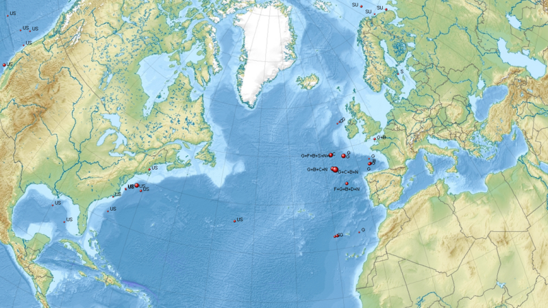
some more hot spots around uk coastal areas and beyond
48°30’ N 13°0’ W
49°50’ N 2°18’ W
55°20’ N 11°20’ W
55°8’ N 12°10’ W
32°37’ N 14°5’ W
32°42’ N 19°30’ W
32°38’ N 20°5’ W
46°27’ N 6°10’ W
45°27’ N 6°16’ W
48°20’ N 13°16’ W
up to 1968.
f
edit on 24-1-2019 by fakedirt because: tidier
a reply to: ThePassenger
Thanks for the reply. Well if you haven't grown any extra limbs or glowing a toxic green from eating the blackberries I think you'd be just fine. I'll look into the book one day and see if I can get it. I know you said you were there in the 90s but do you reckon there are still things buried ? Or would you expect it all to be cleared up by now
Thanks for the reply. Well if you haven't grown any extra limbs or glowing a toxic green from eating the blackberries I think you'd be just fine. I'll look into the book one day and see if I can get it. I know you said you were there in the 90s but do you reckon there are still things buried ? Or would you expect it all to be cleared up by now
a reply to: ThePeaceMaker
I would guess lots remains buried due to corrosion of the barrels its safer to leave under the soil, i don't know what is left. They have filled many adits and shafts with concrete as several came out around the cliffs so any toxic run off would risk getting into the sea. I am sure I read that they have contained old dump sites but unsure how they have done this. There was rumour of soaking the ground around the known sites with a neutralising agent, but that's just hearsay. Its got my interest now! I will have a mooch around the net and share what I find.
I would guess lots remains buried due to corrosion of the barrels its safer to leave under the soil, i don't know what is left. They have filled many adits and shafts with concrete as several came out around the cliffs so any toxic run off would risk getting into the sea. I am sure I read that they have contained old dump sites but unsure how they have done this. There was rumour of soaking the ground around the known sites with a neutralising agent, but that's just hearsay. Its got my interest now! I will have a mooch around the net and share what I find.
a reply to: ThePassenger
I know it will be a long process but having looked around Cornwall and looking at old mines I've noticed that some do go near the sea. After finding out that things were buried at the site and seeing the erosion of the cliffs near the area I did wonder what would happen in years to come if for example the erosion started eroding the cliffs of any of the buried stuff will end up bein exposed and end up falling into the sea. Thanks for your replies the place certainly peeked my interest after yesterday's visit.
I know it will be a long process but having looked around Cornwall and looking at old mines I've noticed that some do go near the sea. After finding out that things were buried at the site and seeing the erosion of the cliffs near the area I did wonder what would happen in years to come if for example the erosion started eroding the cliffs of any of the buried stuff will end up bein exposed and end up falling into the sea. Thanks for your replies the place certainly peeked my interest after yesterday's visit.
a reply to: ThePeaceMaker
Not the same place but you might enjoy this one when you're next down there.
Not the same place but you might enjoy this one when you're next down there.
a reply to: Woody510
I saw this video pop up on my YouTube I watched it a few months ago and completely forgot about it. Thanks for the reminder I'll mention it to my dad as he also loves to have a little explore and I'll try to do some research on it for when I next head down there. I wonder if the police will have something to say if I tried towing that harrier back to essex on the motorways
I saw this video pop up on my YouTube I watched it a few months ago and completely forgot about it. Thanks for the reminder I'll mention it to my dad as he also loves to have a little explore and I'll try to do some research on it for when I next head down there. I wonder if the police will have something to say if I tried towing that harrier back to essex on the motorways
a reply to: ThePeaceMaker
if you check out 28 days later an also the groups on FB, you can some photos of the place ;-)
great post by the way.
snoopyuk
if you check out 28 days later an also the groups on FB, you can some photos of the place ;-)
great post by the way.
snoopyuk
originally posted by: snoopyuk
a reply to: ThePeaceMaker
if you check out 28 days later an also the groups on FB, you can some photos of the place ;-)
great post by the way.
snoopyuk
28 days later .. I thought you meant the film, my dad mentioned parts of the A30 were used to film 28 days later. After googling 28 days later I realised there is a website for urban exploring. Thanks for the heads up
new topics
-
Israel attacking Iran again.
Middle East Issues: 1 hours ago -
Michigan school district cancels lesson on gender identity and pronouns after backlash
Education and Media: 1 hours ago -
When an Angel gets his or her wings
Religion, Faith, And Theology: 2 hours ago -
Comparing the theology of Paul and Hebrews
Religion, Faith, And Theology: 2 hours ago -
Pentagon acknowledges secret UFO project, the Kona Blue program | Vargas Reports
Aliens and UFOs: 3 hours ago -
Boston Dynamics say Farewell to Atlas
Science & Technology: 3 hours ago -
I hate dreaming
Rant: 4 hours ago -
Man sets himself on fire outside Donald Trump trial
Mainstream News: 6 hours ago -
Biden says little kids flip him the bird all the time.
Politicians & People: 6 hours ago -
The Democrats Take Control the House - Look what happened while you were sleeping
US Political Madness: 7 hours ago
top topics
-
The Democrats Take Control the House - Look what happened while you were sleeping
US Political Madness: 7 hours ago, 17 flags -
In an Historic First, In N Out Burger Permanently Closes a Location
Mainstream News: 9 hours ago, 15 flags -
A man of the people
Medical Issues & Conspiracies: 14 hours ago, 10 flags -
Biden says little kids flip him the bird all the time.
Politicians & People: 6 hours ago, 8 flags -
Man sets himself on fire outside Donald Trump trial
Mainstream News: 6 hours ago, 7 flags -
Pentagon acknowledges secret UFO project, the Kona Blue program | Vargas Reports
Aliens and UFOs: 3 hours ago, 6 flags -
Michigan school district cancels lesson on gender identity and pronouns after backlash
Education and Media: 1 hours ago, 4 flags -
4 plans of US elites to defeat Russia
New World Order: 16 hours ago, 4 flags -
Sheetz facing racial discrimination lawsuit for considering criminal history in hiring
Social Issues and Civil Unrest: 7 hours ago, 3 flags -
Israel attacking Iran again.
Middle East Issues: 1 hours ago, 3 flags
active topics
-
Are you ready for the return of Jesus Christ? Have you been cleansed by His blood?
Religion, Faith, And Theology • 21 • : visitedbythem -
A man of the people
Medical Issues & Conspiracies • 12 • : rickymouse -
The Acronym Game .. Pt.3
General Chit Chat • 7733 • : CCoburn -
Post A Funny (T&C Friendly) Pic Part IV: The LOL awakens!
General Chit Chat • 7128 • : baddmove -
Michigan school district cancels lesson on gender identity and pronouns after backlash
Education and Media • 5 • : MetalThunder -
Thousands Of Young Ukrainian Men Trying To Flee The Country To Avoid Conscription And The War
Other Current Events • 52 • : TheMisguidedAngel -
-@TH3WH17ERABB17- -Q- ---TIME TO SHOW THE WORLD--- -Part- --44--
Dissecting Disinformation • 547 • : 777Vader -
Israel attacking Iran again.
Middle East Issues • 14 • : Solvedit -
The Democrats Take Control the House - Look what happened while you were sleeping
US Political Madness • 64 • : KrustyKrab -
Candidate TRUMP Now Has Crazy Judge JUAN MERCHAN After Him - The Stormy Daniels Hush-Money Case.
Political Conspiracies • 403 • : Threadbarer
6