It looks like you're using an Ad Blocker.
Please white-list or disable AboveTopSecret.com in your ad-blocking tool.
Thank you.
Some features of ATS will be disabled while you continue to use an ad-blocker.

Can someone explain what I found :)
page: 3share:
a reply to: FosterVS
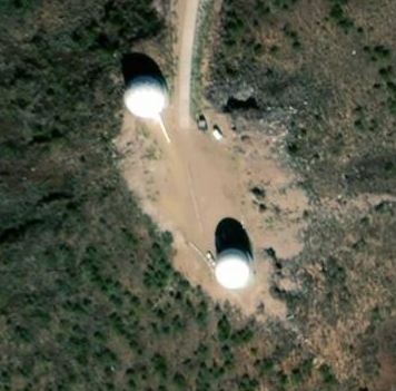
What do you know found another one bet you can't get close to this one follow the road down there's some other stuff like 3 tower things with big round white balls on top some kinda radar or something ...
37.430N 116.852W
37.417N 116.860W
37.400N 116.897W
37.283N 116.646W
37.428N 116.645W
What do you know found another one bet you can't get close to this one follow the road down there's some other stuff like 3 tower things with big round white balls on top some kinda radar or something ...
37.430N 116.852W
37.417N 116.860W
37.400N 116.897W
37.283N 116.646W
37.428N 116.645W
edit on 12/20/2018 by Gargoyle91 because: (no reason given)
originally posted by: chris_stibrany
originally posted by: Bigburgh
a reply to: chris_stibrany
Nellis AFB Range👍🍻🤗
Edit: don't discount paratroopers and seals👍
that's a good point RE airborne troops. Just the lay-out to me though looks like it would be for extremely simple drops if it was used with paratroops etc, at all. Cool find tho.
Anything airborne, that leaves the infrastructure intact
observing what happens next, during the sweep through
could be gas, toxins... cloud burst .. ionospheric projection
a reply to: Gargoyle91
Has any else noticed that the only 2 roads to this town come from 2 Military entries?
Creech Air Force Base
then some gated building/parking lot. Cant tell if its part of Creech, but definitely Military.
only 2 ways in, both through check points.
Also, noticing 2 concentric circles.
1 just south of the town.
2nd if you follow the road north, smack in the middle of the salt lake.
Those circles would make me think. Nuke testing.
Small, maybe Tactical nuke testing.
This little town could have been built to blast test.
Very odd, especially since those buildings look fairly new.
I thought they were Shipping containers.
im also noticing the ultra cleanliness of the town, roads and air force base.
Great Find.
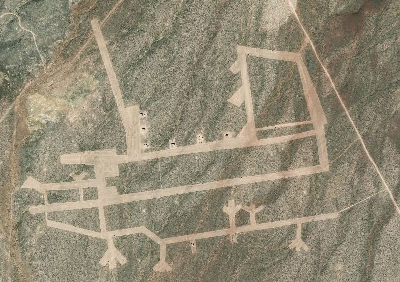
Typical fighter airfield with dispersed aprons
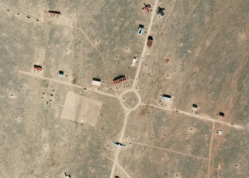
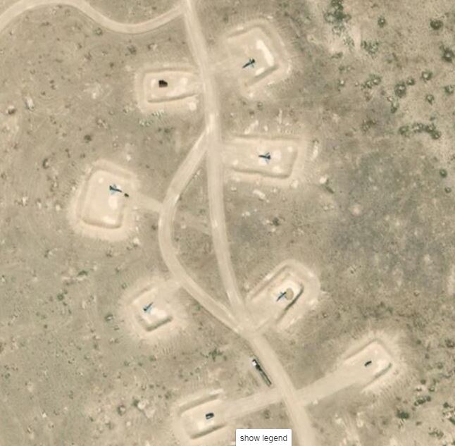
Some sort of target with a motorpool at left and older SAM site at right (star of David shape). You can also see how well the area is pocked/scared with craters and the faded outlines of earlier targets bulldozed into the earth.
Fuel/gas tanks. Not a target.
Revetments for aircraft or SAM site. I can't tell without a wider angle.
If they're all close to the first site, the first site is a practice site/area on range. Mystery solved.
edit on 20-12-2018 by RadioRobert
because: (no reason given)
originally posted by: Alpharosso9999
a reply to: Gargoyle91
Has any else noticed that the only 2 roads to this town come from 2 Military entries?
Creech Air Force Base
then some gated building/parking lot. Cant tell if its part of Creech, but definitely Military.
only 2 ways in, both through check points.
Also, noticing 2 concentric circles.
1 just south of the town.
2nd if you follow the road north, smack in the middle of the salt lake.
Those circles would make me think. Nuke testing.
Small, maybe Tactical nuke testing.
This little town could have been built to blast test.
Very odd, especially since those buildings look fairly new.
I thought they were Shipping containers.
im also noticing the ultra cleanliness of the town, roads and air force base.
Great Find.
They are shipping containers. Try reading the post I made earlier.
originally posted by: Gargoyle91
a reply to: FosterVS
What do you know found another one bet you can't get close to this one follow the road down there's some other stuff like 3 tower things with big round white balls on top some kinda radar or something ...
37.430N 116.852W
37.417N 116.860W
37.400N 116.897W
37.283N 116.646W
37.428N 116.645W
Targets and fake runways used by the Tolicha Peak ECR
37.308389°, -116.783320°
Possibly also used by the Tonopah Test Range.
The white balls are radomes, dishes or radar setup underneath.
originally posted by: RadioRobert
Fuel/gas tanks. Not a target.
Those are radomes. Specifically the comm site on Black Mountain.
a reply to: Gargoyle91
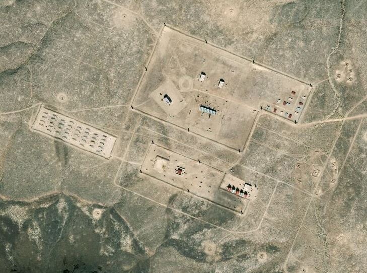
Gonna go out on a limb and say you found some buildings, roads, and what appears to be a possible dual runway airstrip (not trying to be an ass, just stating what I see). Some of the buildings look to be made of old shipping containers (but can't say for sure). As to the purpose of the "installation", I would guess a possible aviation testing ground. Maybe an aviation maintenance and fabrication facility. Really wish we had a google street view, but don't think it'll happen. Intriguing find!
Gonna go out on a limb and say you found some buildings, roads, and what appears to be a possible dual runway airstrip (not trying to be an ass, just stating what I see). Some of the buildings look to be made of old shipping containers (but can't say for sure). As to the purpose of the "installation", I would guess a possible aviation testing ground. Maybe an aviation maintenance and fabrication facility. Really wish we had a google street view, but don't think it'll happen. Intriguing find!
originally posted by: Xcathdra
originally posted by: Gargoyle91
a reply to: Xcathdra
just a bit more in the middle the others will get yo there also I just entered them in google and clicked on the map and the went to Sat view
The coordinates you posted in your opening post arent the same ones you posted in response to my question. The second set are the correct coordinates.
The small airbase southwest of the coords you provided has no change since 2011. The planes in the current image are the same ones going back to 2011 and the positions have no changed.
No idea what the place is. I found this part though -
There is some kind of large sign going over the road.
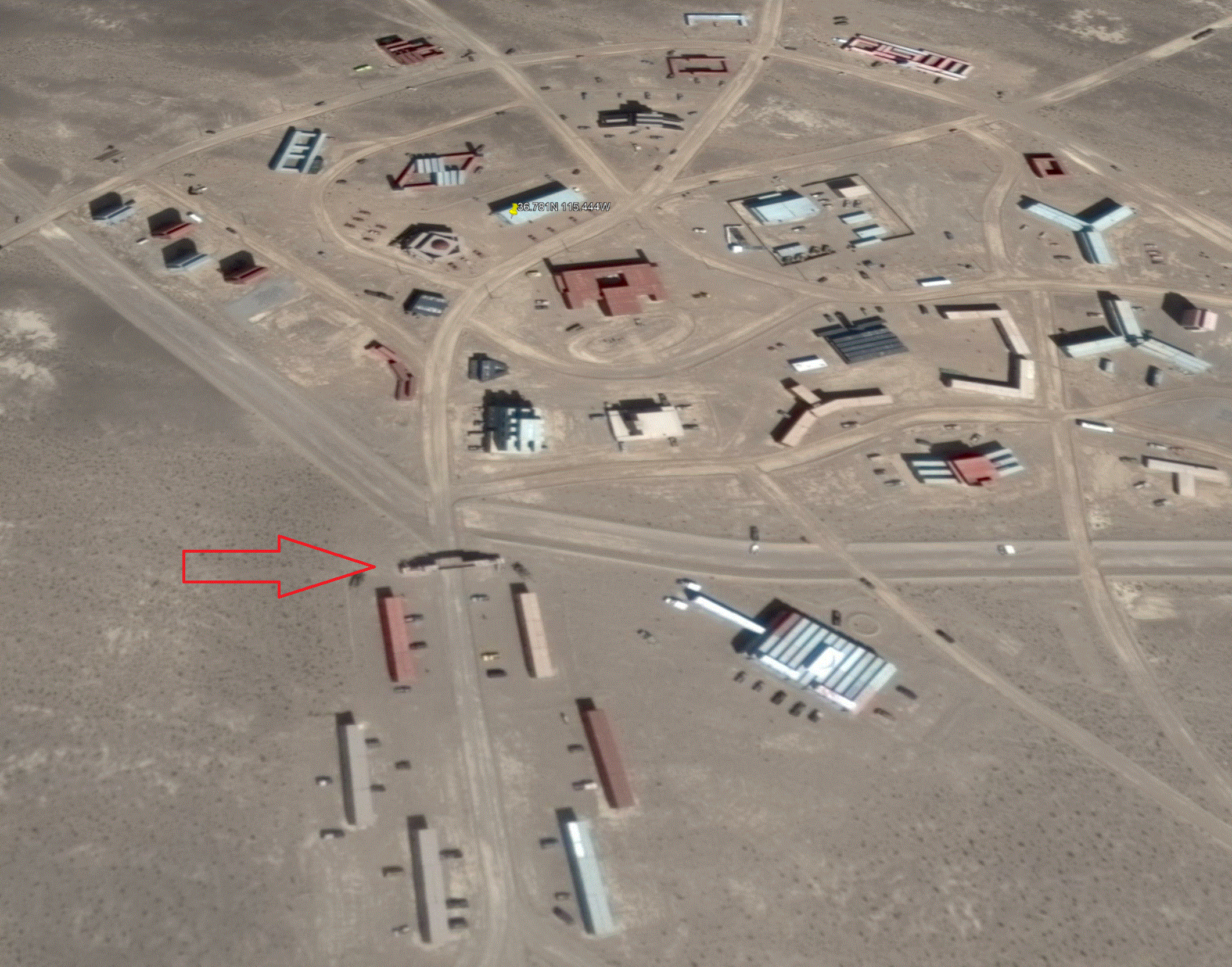
Your arrow is point to a sign:
It says
Welcome #zville
The Picture in the OP looks like a Urban Warfare training range. They use them to train troops on house to house fighting and urban pacification.
Area51Rider is correct, Absolutely an Urban Warfare training center, We have one here on Fort Sill.
new topics
-
Has Tesla manipulated data logs to cover up auto pilot crash?
Automotive Discussion: 1 hours ago -
whistleblower Captain Bill Uhouse on the Kingman UFO recovery
Aliens and UFOs: 6 hours ago -
1980s Arcade
General Chit Chat: 8 hours ago -
Deadpool and Wolverine
Movies: 9 hours ago -
Teenager makes chess history becoming the youngest challenger for the world championship crown
Other Current Events: 10 hours ago -
CIA botched its handling of sexual assault allegations, House intel report says
Breaking Alternative News: 11 hours ago
top topics
-
Lawsuit Seeks to ‘Ban the Jab’ in Florida
Diseases and Pandemics: 13 hours ago, 20 flags -
Starburst galaxy M82 - Webb Vs Hubble
Space Exploration: 16 hours ago, 13 flags -
The Superstition of Full Moons Filling Hospitals Turns Out To Be True!
Medical Issues & Conspiracies: 17 hours ago, 8 flags -
CIA botched its handling of sexual assault allegations, House intel report says
Breaking Alternative News: 11 hours ago, 8 flags -
15 Unhealthiest Sodas On The Market
Health & Wellness: 16 hours ago, 6 flags -
whistleblower Captain Bill Uhouse on the Kingman UFO recovery
Aliens and UFOs: 6 hours ago, 6 flags -
1980s Arcade
General Chit Chat: 8 hours ago, 4 flags -
Deadpool and Wolverine
Movies: 9 hours ago, 3 flags -
Teenager makes chess history becoming the youngest challenger for the world championship crown
Other Current Events: 10 hours ago, 3 flags -
Has Tesla manipulated data logs to cover up auto pilot crash?
Automotive Discussion: 1 hours ago, 0 flags
active topics
-
Lawsuit Seeks to ‘Ban the Jab’ in Florida
Diseases and Pandemics • 23 • : burritocat -
Has Tesla manipulated data logs to cover up auto pilot crash?
Automotive Discussion • 1 • : andy06shake -
15 Unhealthiest Sodas On The Market
Health & Wellness • 36 • : tanstaafl -
My wife just had a very powerful prophetic dream - massive war in Israel...
The Gray Area • 12 • : SchrodingersRat -
-@TH3WH17ERABB17- -Q- ---TIME TO SHOW THE WORLD--- -Part- --44--
Dissecting Disinformation • 606 • : burritocat -
"We're All Hamas" Heard at Columbia University Protests
Social Issues and Civil Unrest • 199 • : FlyersFan -
It takes One to Be; Two to Tango; Three to Create.
Philosophy and Metaphysics • 7 • : Terpene -
Take it to the Media when you protest.. Don't let them ignore you!
Education and Media • 4 • : SchrodingersRat -
They Killed Dr. Who for Good
Rant • 62 • : FlyersFan -
Definitive 9.11 Pentagon EVIDENCE.
9/11 Conspiracies • 421 • : Lazy88