It looks like you're using an Ad Blocker.
Please white-list or disable AboveTopSecret.com in your ad-blocking tool.
Thank you.
Some features of ATS will be disabled while you continue to use an ad-blocker.

Something Strange And Hot Is Lurking Beneath Antarctica's Ice
page: 3share:
In looking at the scientific publications in regards to the freshwater subglacial lakes in Antarctica, I found this very interesting paper. It almost
needs a thread of it's own but fits in quite well with the discussion here.
One of the fascinating things (to me anyway) about this is that due to the extreme weather conditions, scientists are only able to do intensive research for a small portion of the year.
While Lake Vostok has received the lion's share of coverage, it is far from the only lake that has since been discovered beneath the ice in the south polar region. In fact, there are currently major research projects being undertaken at 3 of these newly discovered lakes:
The history of the discovery of these lakes is also quite interesting and has taken place over a number of years and utilizes a number of different methods as science has advanced.
In fact it wasn't until as recently as the 1950s that we were certain that there was one solid landmass beneath the ice and early research was simple and yielded simple results:
Then, again, owing to advances in technology we take another leap in discovery during the next decade, the 1960s:
With the advent of this technology and the fact that it could be deployed via aircraft, much larger areas of the continent were open to exploration and discovery. It wasn't until the 60s were nearly over that the first subglacial lake was discovered, it wasn't Vosotk, btw:
Now, the first mention of 'lakes' in Antarctica actually comes from pilots in the 1950s as a result of visual observations and at first was not connected to water beneath the ice:
Fast forward to the 90s as there was a bit of stagnation during the 70s and into the 80s. In the 90s we have advances in remote sensing from satellite platforms:
Armed with this data, scientists went back to the data which had previously been recorded from the earlier seismic surveys and began looking for similar correlations. What was found was that there were a great many more such indications of water beneath the ice. It is from this era that Vostok gained is fame:
(continued and sourced next post)
One of the fascinating things (to me anyway) about this is that due to the extreme weather conditions, scientists are only able to do intensive research for a small portion of the year.
While Lake Vostok has received the lion's share of coverage, it is far from the only lake that has since been discovered beneath the ice in the south polar region. In fact, there are currently major research projects being undertaken at 3 of these newly discovered lakes:
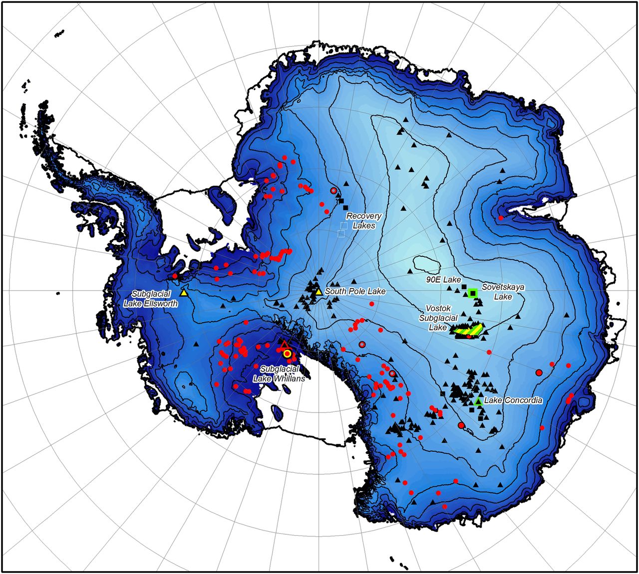
One example of such research is the exploration of Antarctic subglacial lakes, bodies of water at the bed of the ice sheet, which SCAR has acted to facilitate over the past 20 years, and which culminated in field programmes to measure and sample three individual lakes in 2012/13: Lake Vostok, led by a Russian team; Lake Ellsworth, led by the British; and Lake Whillans, led by the USA.
The history of the discovery of these lakes is also quite interesting and has taken place over a number of years and utilizes a number of different methods as science has advanced.
In fact it wasn't until as recently as the 1950s that we were certain that there was one solid landmass beneath the ice and early research was simple and yielded simple results:
The experiment is simple: a small explosion sets off a sound wave, which travels down to the ice base, where it is reflected and subsequently recorded by the receiver. The two-way travel time is noted and converted into distance as the speed of sound in ice is known reasonably well. Thus, a measure of ice thickness is possible using a simple seismic reflection test, adapted for harsh polar field conditions by Robin. While the process of data acquisition is time consuming (two boreholes for each data point, meaning that a single datum would take at least a day to record), by aligning measurements along a survey line a profile of ice-sheet thickness, and therefore bed topography, could be derived. In this way, the first two-dimensional cross-section measurements of the Antarctic ice sheet and its subglacial landscape were obtained.
...
The data collected by these surveys transformed our knowledge of the continent, proving it to be a single landmass, showing the ice to be several kilometres thick (at Vostok Station, for example, it was measured as c. 3.7 km) and, in large parts of West Antarctica, revealing the bed to be over a kilometre below sea-level.
Then, again, owing to advances in technology we take another leap in discovery during the next decade, the 1960s:
Radio-echo sounding (RES), as it was known (essentially ice-penetrating radar), was able to chart ice thickness, therefore, in an analogous way to seismic sounding. The major advantage of RES over seismic sounding was that it did not require the drilling of boreholes and could be deployed on a moving platform to obtain cross-section information during transit. The most significant innovation by Evans and Robin was to consider how RES could be mounted and used effectively on aircraft. In the late 1960s their Cambridge team, supported by funding and logistics from the US Antarctic Research Program, demonstrated the use of airborne RES with instant and revolutionary success.
With the advent of this technology and the fact that it could be deployed via aircraft, much larger areas of the continent were open to exploration and discovery. It wasn't until the 60s were nearly over that the first subglacial lake was discovered, it wasn't Vosotk, btw:
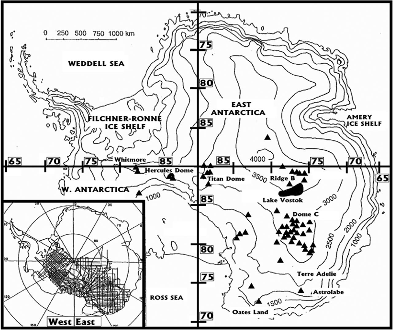
For example, the first subglacial lake was discovered from data collected on one of the first long-range survey flights in 1969. An unusually flat subglacial radio-echo surface beneath the Russian base at Sovetskaya Station in central East Antarctica was received and attributed to a ‘thick layer of water beneath the ice’ (Robin et al. 1970). Shortly afterwards, the first inventory of 17 subglacial lakes was documented from East Antarctic RES data (Oswald & Robin 1973; Fig. 1). Lake Vostok, the gigantic subglacial lake in East Antarctica, was detected by RES in December 1974 (Robin et al. 1977), although its true extent was not established at this time. These early discoveries showed the bed of the Antarctic Ice Sheet to be wet in many places, that water could be stored in ‘lakes’ and that the distribution of subglacial lakes was widespread across the surveyed regions of the continent.
Now, the first mention of 'lakes' in Antarctica actually comes from pilots in the 1950s as a result of visual observations and at first was not connected to water beneath the ice:
Although subglacial lakes were undeniably discovered using RES by Robin and his team, the first mention of ‘lakes’ in Antarctica was made by a Russian pilot (Robinson 1960) who, as part of an experiment to determine ice-surface landmarks to aid flight orientation, identified ‘oval depressions with gentle shores’ on the ice surface. Although these features were referred to as ‘lakes’ by pilots who observed them, such as Robinson, there was no connection made between these features and water beneath the surface.
Fast forward to the 90s as there was a bit of stagnation during the 70s and into the 80s. In the 90s we have advances in remote sensing from satellite platforms:
Ridley et al. (1993) analysed ERS-1 data from East Antarctica, and noticed a remarkably flat surface at and to the north of Vostok Station. This surface, which pilots may have observed in the 1950s, coincides remarkably well with RES evidence of a large subglacial lake established by Robin et al. (1977), and delineates the outline of the lake beneath (the ice surface above large subglacial lakes is flat owing to the frictionless contact between ice and water at the ice-sheet base). The combination of satellite and RES data confirmed that this lake, Lake Vostok, was over 240 km long and more than 50 km wide. These data also showed the existence of the lake directly beneath Vostok Station, where Kapitsa and others had collected seismic ice thickness measurements around 30 years previously.
Armed with this data, scientists went back to the data which had previously been recorded from the earlier seismic surveys and began looking for similar correlations. What was found was that there were a great many more such indications of water beneath the ice. It is from this era that Vostok gained is fame:
Unlike previous publications on subglacial lakes during the 1970s, Kapitsa et al. (1996), which featured on the front cover of Nature magazine, was met by worldwide media attention and considerable new scientific interest, particularly from the microbiological community, which instantly regarded the lake as an extreme yet viable habitat for life, cut off from the rest of the planet for sufficient time to allow novel adaptations to have developed (Ellis-Evans & Wynn-Williams 1996).
(continued and sourced next post)
edit on 18-11-2018 by jadedANDcynical because: wrong decade in one sentence
(continued from previous post)
At this time, the number of subglacial lakes known about grew rapidly:
Then something new and completely unexpected was discovered. At first it was thought that these subglacial lakes were isolated and could potentially represent untouched sources of discrete biomes cut off from one another. That all changed when this was found:
This meant that, far from being separate and removed from one another, there could be a mixing of lake water between different lakes separated by huge distances:
Make note of this portion, "confirming wet-based conditions over around half the ice sheet." Think about that for a second, nearly half of the area beneath the ice actually has liquid water present.
Now, in reading this paper, I learned something I don't think I had seen an any of the news reports on the research being done at Vostok. That being that the ice cores already taken contained ice which had accreted from the surface of the lake rather than having been laid down from above:
This is where the controversy over potential contamination by the chemicals used to keep the drill bits from freezing comes:
Much wrangling and discussion ensued over how best to continue the research and ensure the pristine samples could be obtained without the possibility of contamination from the surface. There is much more detail in this paper and I would strongly encourage anyone with an interest in the scientific study of these subglacial lakes and what life may be like in them to read all the way through this article. It is well written and does not contain an overabundance of scientific jargon thus making it much more approachable to the average person.
A 60-year international history of Antarctic subglacial lake exploration
At this time, the number of subglacial lakes known about grew rapidly:
The establishment of the geographical scale of Lake Vostok in 1996, and speculative ideas on its potential contents, was supplemented in the same year by a second inventory of 77 Antarctic subglacial lakes (Fig. 2), which was collated from a reanalysis of the 1970s RES data collected by Robin's team 20 years earlier (Siegert et al. 1996).
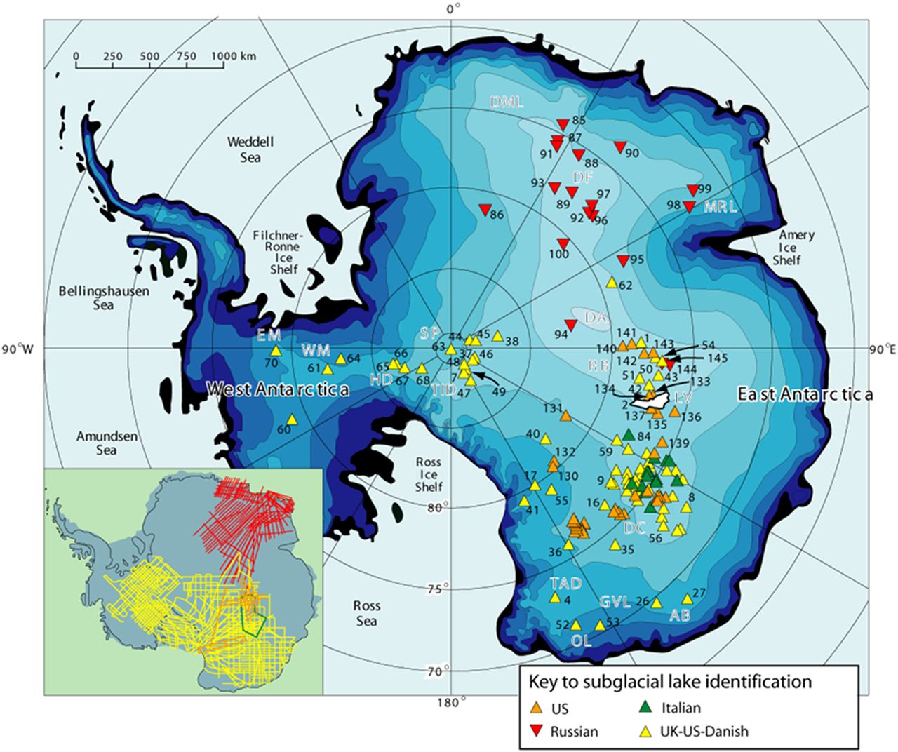
Nine years later, as more RES data were collected by the USA, UK, Russia and Italy, the inventory of subglacial lakes grew to 145 (Siegert et al. 2005; Fig. 3).
Then something new and completely unexpected was discovered. At first it was thought that these subglacial lakes were isolated and could potentially represent untouched sources of discrete biomes cut off from one another. That all changed when this was found:
Then, another remarkable finding was made. Analysis of ERS-1 altimetric time-series data revealed an area of the central East Antarctic ice sheet to have reduced in elevation by more than 3 m, far in excess of the instrumental error, over 14 months between 1997 and 1999. During the same period, three areas of the ice sheet more than 200 km away rose up by more than a metre. Given that the regions of uplift coincided with the positions of known subglacial lakes at the mouth of a major subglacial valley known as the Adventure Trench, and that the area of subsidence was located at the head of this trench, the measurements were interpreted as evidence of an outburst of subglacial lake water, flowing over 200 km along the axis of the trench into a series of other lakes (Wingham et al. 2006).
This meant that, far from being separate and removed from one another, there could be a mixing of lake water between different lakes separated by huge distances:
Further analysis of satellite interferometry (Gray et al. 2005) and laser altimetry revealed more evidence for basal water flow and subglacial lake outbursts, particularly beneath Whillans Ice Stream (Fricker et al. 2007; 2016), leading to an inventory of 130 so-called ‘active’ subglacial lakes (Smith et al. 2009). Combined with lakes detected from newly acquired RES data, these active lakes pushed the tally within the fourth version of the inventory of Antarctic subglacial lakes to 381 (Wright & Siegert 2011, 2012; Fig. 4), scattered throughout the continent, confirming wet-based conditions over around half the ice sheet. Following subsequent discoveries, by 2016 the tally of known, discrete subglacial lake locations stood at 402 (Siegert et al. 2016a).
Make note of this portion, "confirming wet-based conditions over around half the ice sheet." Think about that for a second, nearly half of the area beneath the ice actually has liquid water present.
Now, in reading this paper, I learned something I don't think I had seen an any of the news reports on the research being done at Vostok. That being that the ice cores already taken contained ice which had accreted from the surface of the lake rather than having been laid down from above:
Studies of the basal units of the ice core, expecting to take the climate record further back, revealed virtually no gas content, however. Rather than being formed by ice accumulating at the surface, this gas-poor ice was formed instead by lake water freezing to the ice sheet underside, creating over 200 m of ‘accreted ice’ at the ice sheet base. Thus, the ice core had collected a frozen sample of lake water (Jouzel et al. 1999).
This is where the controversy over potential contamination by the chemicals used to keep the drill bits from freezing comes:
One problem with the accreted ice samples was that their extraction from the ice sheet involved their being subjected to the ice-core antifreeze (in this case kerosene). As the samples were not obtained cleanly, and were thus potentially contaminated, the findings of life within the accreted ice were open to challenge.
Much wrangling and discussion ensued over how best to continue the research and ensure the pristine samples could be obtained without the possibility of contamination from the surface. There is much more detail in this paper and I would strongly encourage anyone with an interest in the scientific study of these subglacial lakes and what life may be like in them to read all the way through this article. It is well written and does not contain an overabundance of scientific jargon thus making it much more approachable to the average person.
A 60-year international history of Antarctic subglacial lake exploration
a reply to: jadedANDcynical
Wouldn't it be cool if they could come up with a laser based drill or some other tech that wouldn't require "anti freeze" but could just cut through cleanly without contamination? Although it might be scary too if there are virus or bacteria down there that could wipe us out. Unless Mother Nature has that as her backup plan to get rid of us human parasites heh.
Wouldn't it be cool if they could come up with a laser based drill or some other tech that wouldn't require "anti freeze" but could just cut through cleanly without contamination? Although it might be scary too if there are virus or bacteria down there that could wipe us out. Unless Mother Nature has that as her backup plan to get rid of us human parasites heh.
a reply to: Lilroanie
Lol, yeah way back in the late 80's to early 90's my buddies and myself postulated that there might be some sort of virus or bacteria come from either these subglacial lakes or even perhaps within the areas of the rain forests which had been defoliated break out of their 'containment' and wreak havoc upon a population which has not encountered them due to the remote location and amount of time spent in isolation from the rest of the world.
In regards to obtaining pristine samples from various drilling methods, from the paper I linked above:
This produced the following:
There was a similar attempt at Lake Ellsworth but it ran afoul some technical difficulties owing to the extreme climate; see linked paper for details.
Lol, yeah way back in the late 80's to early 90's my buddies and myself postulated that there might be some sort of virus or bacteria come from either these subglacial lakes or even perhaps within the areas of the rain forests which had been defoliated break out of their 'containment' and wreak havoc upon a population which has not encountered them due to the remote location and amount of time spent in isolation from the rest of the world.
In regards to obtaining pristine samples from various drilling methods, from the paper I linked above:
In January 2013, Lake Whillans became the first subglacial lake to be accessed using a clean hot water drill, and measured and sampled using clean instruments following agreed protocols (Fricker et al. 2011). As a consequence, samples retrieved became the first from a subglacial system in which contamination issues could be assured, adding confidence to the scientific results.
This produced the following:
Samples of water and sediment were taken, and returned to the surface for both immediate inspection and transfer to laboratories in the USA. They showed that water within Lake Whillans contained ‘metabolically active’ micro-organisms, and that it was derived primarily from glacial ice melt with a minor component of seawater (Christner et al. 2014; Michaud et al. 2016), making it unique among known subglacial environments within Antarctica.
There was a similar attempt at Lake Ellsworth but it ran afoul some technical difficulties owing to the extreme climate; see linked paper for details.
a reply to: jadedANDcynical
But wouldn't the hot water be "contaminated"? Unless the water came from the lake which obviously isn't the case it would have surface "stuff" in it right?
But wouldn't the hot water be "contaminated"? Unless the water came from the lake which obviously isn't the case it would have surface "stuff" in it right?
a reply to: Lilroanie
From the abstract on the paper regarding the process used to obtain the samples:
A microbiologically clean strategy for access to the Whillans Ice Stream subglacial environment
From the abstract on the paper regarding the process used to obtain the samples:
WISSARD hot water drilling efforts will include a custom water treatment system designed to remove micron and sub-micron sized particles (biotic and abiotic), irradiate the drilling water with germicidal ultraviolet (UV) radiation, and pasteurize the water to reduce the viability of persisting microbial contamination. Our clean access protocols also include methods to reduce microbial contamination on the surfaces of cables/hoses and down-borehole equipment using germicidal UV exposure and chemical disinfection. This paper presents experimental data showing that our protocols will meet expectations established by international agreement between participating Antarctic nations.
A microbiologically clean strategy for access to the Whillans Ice Stream subglacial environment
a reply to: jadedANDcynical
Thanks J&C! I have a hard time anymore reading the "tough" papers due to my eyes and migraines, so I very much appreciate your help in pointing that out!
Thanks J&C! I have a hard time anymore reading the "tough" papers due to my eyes and migraines, so I very much appreciate your help in pointing that out!
it is called the south magnetic pole for a reason
there are magnetic waves emanating from the central core (much like the north end of a bar magnet emits charged particles). this may account for some of the heating effect
there are magnetic waves emanating from the central core (much like the north end of a bar magnet emits charged particles). this may account for some of the heating effect
In looking further at tectonics in Antarctica, I have found some interesting articles on the subject.
Antarctic Tectonics
The above image shows the crustal thickness beneath the continent. Note that the areas of greatest positive anomoly are also the same areas in which Lake Vostok and the hot spot as referenced in the OP are also located.
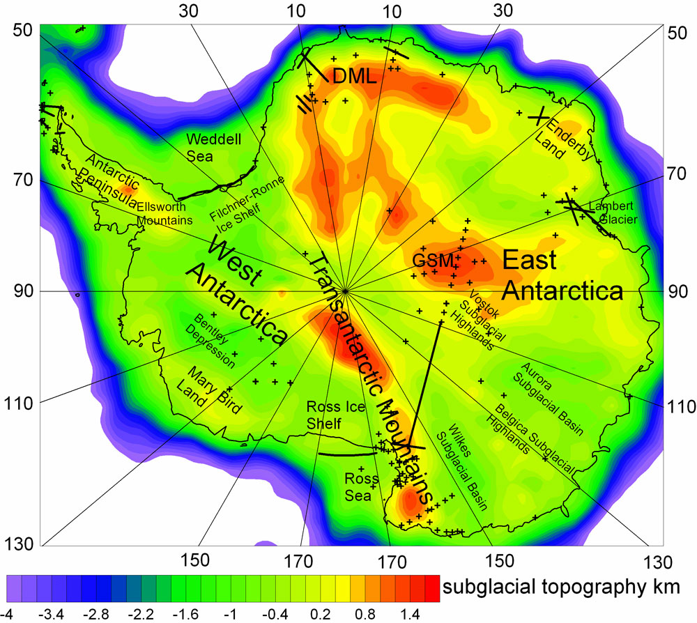
The second image shows a map of Antarctica with the relief of the crust thickness below it's ice as indicated by seismic data. Abbreviations: DML, Dronning Maud Land; GSM, Gamburtsev Subglacial Mountains. CREDIT: Baranov, A., Morelli, A., The Moho depth map of the Antarctica region, Tectonophysics (2013).
Antarctic Tectonics
The above image shows the crustal thickness beneath the continent. Note that the areas of greatest positive anomoly are also the same areas in which Lake Vostok and the hot spot as referenced in the OP are also located.
a reply to: jadedANDcynical
It's a fk LAVA.
Something Strange And Hot Is Lurking Beneath Antarctica's Ice
It's a fk LAVA.
Maybe Japan is dumping their nuclear cores from Fukushima...or its ManBearPig...probably ManBearPig.
a reply to: jadedANDcynical
Thanks for the info!
Good work going into this thread. Much appreciated.
Thanks for the info!
Good work going into this thread. Much appreciated.
Very interesting research J&C
SF
SF
edit on 16-1-2019 by burntheships because: (no reason given)
new topics
-
Electrical tricks for saving money
Education and Media: 11 minutes ago -
VP's Secret Service agent brawls with other agents at Andrews
Mainstream News: 1 hours ago -
Sunak spinning the sickness figures
Other Current Events: 2 hours ago -
Nearly 70% Of Americans Want Talks To End War In Ukraine
Political Issues: 2 hours ago -
Late Night with the Devil - a really good unusual modern horror film.
Movies: 4 hours ago -
Cats Used as Live Bait to Train Ferocious Pitbulls in Illegal NYC Dogfighting
Social Issues and Civil Unrest: 5 hours ago -
The Good News According to Jesus - Episode 1
Religion, Faith, And Theology: 7 hours ago -
HORRIBLE !! Russian Soldier Drinking Own Urine To Survive In Battle
World War Three: 9 hours ago
top topics
-
SETI chief says US has no evidence for alien technology. 'And we never have'
Aliens and UFOs: 16 hours ago, 8 flags -
Florida man's trip overseas ends in shock over $143,000 T-Mobile phone bill
Social Issues and Civil Unrest: 12 hours ago, 8 flags -
Cats Used as Live Bait to Train Ferocious Pitbulls in Illegal NYC Dogfighting
Social Issues and Civil Unrest: 5 hours ago, 7 flags -
VP's Secret Service agent brawls with other agents at Andrews
Mainstream News: 1 hours ago, 6 flags -
Former Labour minister Frank Field dies aged 81
People: 14 hours ago, 4 flags -
Bobiverse
Fantasy & Science Fiction: 12 hours ago, 3 flags -
HORRIBLE !! Russian Soldier Drinking Own Urine To Survive In Battle
World War Three: 9 hours ago, 3 flags -
Nearly 70% Of Americans Want Talks To End War In Ukraine
Political Issues: 2 hours ago, 3 flags -
Sunak spinning the sickness figures
Other Current Events: 2 hours ago, 3 flags -
Late Night with the Devil - a really good unusual modern horror film.
Movies: 4 hours ago, 2 flags
active topics
-
SETI chief says US has no evidence for alien technology. 'And we never have'
Aliens and UFOs • 41 • : TheMisguidedAngel -
Naked Eye Supernova Erupting in the T Coronae Borealis
Space Exploration • 13 • : Therealbeverage -
The Real Reason Behind the Sean Combes Exposure
Political Conspiracies • 45 • : ThatSmellsStrange -
VP's Secret Service agent brawls with other agents at Andrews
Mainstream News • 14 • : lilzazz -
Electrical tricks for saving money
Education and Media • 0 • : annonentity -
Late Night with the Devil - a really good unusual modern horror film.
Movies • 4 • : DBCowboy -
Hate makes for strange bedfellows
US Political Madness • 41 • : Solvedit -
Nearly 70% Of Americans Want Talks To End War In Ukraine
Political Issues • 11 • : DBCowboy -
President BIDEN Vows to Make Americans Pay More Federal Taxes in 2025 - Political Suicide.
2024 Elections • 124 • : Justoneman -
Ditching physical money
History • 20 • : GENERAL EYES