It looks like you're using an Ad Blocker.
Please white-list or disable AboveTopSecret.com in your ad-blocking tool.
Thank you.
Some features of ATS will be disabled while you continue to use an ad-blocker.

Ground shaking during devastating flood offers new insights
page: 117
share:
Getting back to some of my roots here on ATS and away from the political theater, I bring you this thread of an event that took place back in 2016,
but I can find no mention of here on ATS.
On July 5, 2016 a natural dam ruptured catastrophically releasing a glacial lake. This was attributed to an earthquake which took place in the region a year before, which did get mentions here on ATS (see related threads below) at the time.
Source - PhysOrg
Not only was the wall of water recorded on seismometers, but so was the debris washed down by that water.
The paper mentioned in the first excerpt goes into detail about how these events could possibly be responsible for more erosion in the region than the monsoons with their months of unending rain. The glacial lake outburst flood (GLOF) is a short lived, yet catastrophically destructive event that could be set off in a number of ways.
This specific event was not necessarily directly tied to the earthquake which occurred in the region the prior year, however it was situated within the impact zone of said quake:
It is entirely possible that had the earthquake not occurred, then the moraine would not have been breached.
An array of seismometers were placed in the wake of the earthquake to study the area and they caught the resultant flood:
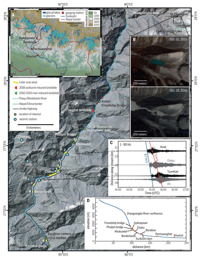
One can see instantly that there is a great deal of elevation change from the altitude of the lake down to the lowest point of the river.
Now when one thinks of flooding, most of the time one thinks that the damage is due to inundation by water. Well, this is not the case with a flood event such as described in this paper:
The rushing water along with the coarse sediment (lol, boulders are considered coarse sediment) eat away at the banks of the river due to the increased flow rate of the water in such a short period of time by orders of magnitude. All of this water and flowing sediment made a considerable impact upon the topography in the area:
That's a rough increase of 40% to the width of the entire river channel.
What's more is that these events seem to not be terribly rare at all:
A return period of about 30 years, is about the same as the return period of a catastrophic hurricane in the Texas Gulf coast (around every 25 years), and much much shorter than the typical return period of sizable earthquakes.
Lots of great data in this paper, but they just couldn't resist plugging anthropomorphic climate change as a threat at the end:
Glacial lake outburst floods as drivers of fluvial erosion in the Himalaya - source paper
Related threads:
7.5 Mag earthquake Nepal - Upgraded to 7.9 USGS
oh no...NEPAL just had another 7.4 ...this could be bad...
I couldn't find any threads on the flood when it happened, if I missed any, please link them in the replies.
So, ATS, what do ya think?
On July 5, 2016 a natural dam ruptured catastrophically releasing a glacial lake. This was attributed to an earthquake which took place in the region a year before, which did get mentions here on ATS (see related threads below) at the time.
A devastating wall of water gushed down the Bhotekoshi/Sunkoshi River in Nepal on July 5, 2016. It came from a lake that had been dammed by a glacial moraine, but the dam broke and discharged more than 100,000 tons of water all at once. An international team of GFZ and Nepali scientists was able to record the sudden outburst with seismometers deployed the year before in the wake of the catastrophic Ghorka earthquake in April 2015. In a study to be published in Science, the authors argue that such major flood events have a greater impact on erosion rates than the annual monsoon rainfalls.
Source - PhysOrg
Not only was the wall of water recorded on seismometers, but so was the debris washed down by that water.
"We could identify two distinct pulses," says Kristen Cook. The first came from the wall of water, the second one only seconds later from rocks and coarse sediment within the water. The latter caused the biggest damage. Bridges were destroyed as well as hydro-power stations and roads. In the aftermath, a number of landslides came down as the river banks were destabilized by the erosive force of the water.
The paper mentioned in the first excerpt goes into detail about how these events could possibly be responsible for more erosion in the region than the monsoons with their months of unending rain. The glacial lake outburst flood (GLOF) is a short lived, yet catastrophically destructive event that could be set off in a number of ways.
These floods originate from lakes that have formed behind a landslide dam or in association with a glacier, dammed by a frontal moraine or glacial ice. Such lakes can drain catastrophically for several reasons, including mass movements or avalanches into the lake, seismic activity, piping within the dam, overtopping of the dam, or degradation of blocking ice (4, 6). The resulting floods can have short-lived discharges up to several orders of magnitude higher than background discharges in the receiving rivers (7).
This specific event was not necessarily directly tied to the earthquake which occurred in the region the prior year, however it was situated within the impact zone of said quake:
The cause of the breach is unknown, but fresh deposits above the lake suggest that it may have been associated with a debris flow event, possibly increasing the volume of the flood (Fig. 1B). ... The zone of damage sits within the area affected by strong ground motion and landsliding induced by the 2015 moment magnitude 7.8 Gorkha earthquake, which had an estimated return time of a few hundred years (15, 16).
It is entirely possible that had the earthquake not occurred, then the moraine would not have been breached.
An array of seismometers were placed in the wake of the earthquake to study the area and they caught the resultant flood:
One can see instantly that there is a great deal of elevation change from the altitude of the lake down to the lowest point of the river.
Now when one thinks of flooding, most of the time one thinks that the damage is due to inundation by water. Well, this is not the case with a flood event such as described in this paper:
The flood impact extended into the adjacent hillslopes through undercutting and destabilization of the river banks, leading to bank collapses, slumps, and landslides. The extensive flood-induced damage to local infrastructure was almost exclusively the result of bank erosion and mass wasting, rather than inundation (fig. S4).
The rushing water along with the coarse sediment (lol, boulders are considered coarse sediment) eat away at the banks of the river due to the increased flow rate of the water in such a short period of time by orders of magnitude. All of this water and flowing sediment made a considerable impact upon the topography in the area:
Analysis of 5-m-resolution RapidEye imagery (table S3) indicates that the 2016 GLOF caused the mean width of the active channel between the Zhangzangbo confluence and Barabise to increase from 29.5 ± 3 m in 2015 to 41.3 ± 3 m in 2016, with highly variable widening throughout the mapped area (Fig. 3)
That's a rough increase of 40% to the width of the entire river channel.
What's more is that these events seem to not be terribly rare at all:
The frequency of GLOFs in the central Himalaya is difficult to establish, because records are incomplete and recorded floods may not be correctly identified as GLOFs (3, 23). Nevertheless, GLOFs are relatively common in the Himalaya, with a major flood occurring at least once every 2 years on average (4, 24–26). The Bhotekoshi River has experienced GLOFs in 1935, 1964, 1981, and 2016, suggesting a return period of about 30 years (2).
A return period of about 30 years, is about the same as the return period of a catastrophic hurricane in the Texas Gulf coast (around every 25 years), and much much shorter than the typical return period of sizable earthquakes.
Lots of great data in this paper, but they just couldn't resist plugging anthropomorphic climate change as a threat at the end:
A warming climate is thought to promote glacial lake formation in some areas as retreating glaciers create space for lakes behind abandoned end moraines and increased melting rates supply more water to potential lakes. This, in turn, may increase GLOF frequency and/or magnitude (25, 31–33). The potential for increased GLOF activity in response to climate change therefore not only represents increased risk to communities in these regions but may also strongly affect the pace of landscape change in a way that is not reflected in precipitation-dependent erosion models.
Glacial lake outburst floods as drivers of fluvial erosion in the Himalaya - source paper
Related threads:
7.5 Mag earthquake Nepal - Upgraded to 7.9 USGS
oh no...NEPAL just had another 7.4 ...this could be bad...
I couldn't find any threads on the flood when it happened, if I missed any, please link them in the replies.
So, ATS, what do ya think?
edit on 6-10-2018 by jadedANDcynical because: forgot source
I think the same thing happened on a much larger scale to form monument valley in the USA. The Ice and earthen damn broke free during the warming
period of the last ice age.. Can you Imagine being an Indian stepping outside your Teepee only to see a wall of water several yards/meters tall
bearing down upon you ?? Bad day in flat rock no doubt..
Hmm, take this info and imagine the Mississippi river , the New Madrid Seismic Zone and the Great lakes.
a reply to: jadedANDcynical
I wouldn't doubt this for a second.
When a dam bursts, it'd be like an inland tsunami. The sheer force of the wave would wipe away the top soil, the trees whose dead foliage provide the soil will not return for years, and therefore erosion.
I wouldn't doubt this for a second.
When a dam bursts, it'd be like an inland tsunami. The sheer force of the wave would wipe away the top soil, the trees whose dead foliage provide the soil will not return for years, and therefore erosion.
a reply to: jadedANDcynical
Thanks for posting this.
I'm a total neophyte about this stuff, but it seems to me a 7.8 EQ surely could have changed things that eventually caused the dam to rupture.
7.8 is pretty damn big!!!!
Thanks for posting this.
I'm a total neophyte about this stuff, but it seems to me a 7.8 EQ surely could have changed things that eventually caused the dam to rupture.
7.8 is pretty damn big!!!!
Decades ago folks used to say the rain helps prevent quakes
but nowin recent years growing fear of quakes following torrential rain/flooding seems par for course in wake of all the fracking and now chemdroughting going on across the Nation.
but nowin recent years growing fear of quakes following torrential rain/flooding seems par for course in wake of all the fracking and now chemdroughting going on across the Nation.
a reply to: DontTreadOnMe
Yeah, anything M7+ and shallow is going to equate to a tremendous amount of damage at the surface.
A flood event such as described in this thread is something along the lines of an immensely powerful hydro-jet. We're talking something along the lines of hours for this entire lake to empty down the gorge. That's a prodigious flow rate and when you also consider that the river bed is picked up along the way, that ends up acting as an additional abrasive to the riverbanks and hillsides it passes.
Then as it erodes those same riverbanks, more sediments, rock, boulders, etc. are added to the high powered slurry melting further damage downstream inevitable.
Looking back at the news stories from the time, it's all about the impact the monsoons have upon flash flooding in the area.
The satellite footage from the OP paper is clear where the lake draining is concerned and there can be no doubt as to the resultant outcomes.
edit on 7-10-2018 by jadedANDcynical because: (no reason given)
new topics
-
God's Righteousness is Greater than Our Wrath
Religion, Faith, And Theology: 3 hours ago -
Electrical tricks for saving money
Education and Media: 6 hours ago -
VP's Secret Service agent brawls with other agents at Andrews
Mainstream News: 7 hours ago -
Sunak spinning the sickness figures
Other Current Events: 8 hours ago -
Nearly 70% Of Americans Want Talks To End War In Ukraine
Political Issues: 8 hours ago -
Late Night with the Devil - a really good unusual modern horror film.
Movies: 10 hours ago -
Cats Used as Live Bait to Train Ferocious Pitbulls in Illegal NYC Dogfighting
Social Issues and Civil Unrest: 11 hours ago
top topics
-
VP's Secret Service agent brawls with other agents at Andrews
Mainstream News: 7 hours ago, 9 flags -
Cats Used as Live Bait to Train Ferocious Pitbulls in Illegal NYC Dogfighting
Social Issues and Civil Unrest: 11 hours ago, 8 flags -
Electrical tricks for saving money
Education and Media: 6 hours ago, 4 flags -
HORRIBLE !! Russian Soldier Drinking Own Urine To Survive In Battle
World War Three: 15 hours ago, 3 flags -
Nearly 70% Of Americans Want Talks To End War In Ukraine
Political Issues: 8 hours ago, 3 flags -
Sunak spinning the sickness figures
Other Current Events: 8 hours ago, 3 flags -
Late Night with the Devil - a really good unusual modern horror film.
Movies: 10 hours ago, 2 flags -
The Good News According to Jesus - Episode 1
Religion, Faith, And Theology: 13 hours ago, 1 flags -
God's Righteousness is Greater than Our Wrath
Religion, Faith, And Theology: 3 hours ago, 0 flags
active topics
-
VP's Secret Service agent brawls with other agents at Andrews
Mainstream News • 41 • : ThatSmellsStrange -
HORRIBLE !! Russian Soldier Drinking Own Urine To Survive In Battle
World War Three • 32 • : DaRAGE -
New whistleblower Jason Sands speaks on Twitter Spaces last night.
Aliens and UFOs • 55 • : baablacksheep1 -
Cats Used as Live Bait to Train Ferocious Pitbulls in Illegal NYC Dogfighting
Social Issues and Civil Unrest • 20 • : Asher47 -
Nearly 70% Of Americans Want Talks To End War In Ukraine
Political Issues • 12 • : Asher47 -
Electrical tricks for saving money
Education and Media • 4 • : Lumenari -
DONALD J. TRUMP - 2024 Candidate for President - His Communications to Americans and the World.
2024 Elections • 514 • : WeMustCare -
The Acronym Game .. Pt.3
General Chit Chat • 7744 • : bally001 -
Truth Social goes public, be careful not to lose your money
Mainstream News • 128 • : Astyanax -
Sunak spinning the sickness figures
Other Current Events • 5 • : glen200376
17