It looks like you're using an Ad Blocker.
Please white-list or disable AboveTopSecret.com in your ad-blocking tool.
Thank you.
Some features of ATS will be disabled while you continue to use an ad-blocker.

Mojave Desert Facility
page: 1share:
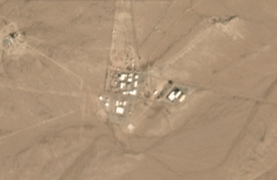
Does anyone know what this facility at 35°32'32.3"N 117°15'47.7"W is?
www.otherhand.org...
This page speaks about a little bit and has a picture of something large sitting in front of it. What do I find particularly interesting is what looks to be fuel tanks at 35°32'39.0"N 117°15'51.2"W. There seems to be radar/antennae at 35°32'52.1"N 117°15'33.5"W and 35°32'12.3"N 117°15'02.4"W.
Looking at the general area, it seems to be a very secure area far away from public access. Just down the road at 35.520561, -117.297379 there is another crop of buildings with a lot of stuff laying out in the open.
There seems to be a gate/guard shack at 35.525045, -117.364547 and there are other various buildings/facilities scattered throughout the area.
edit on 557Thursdayam2018-09-27T07:22:50-05:00kThu2018710 by BlackDog10 because: (no reason given)
a reply to: BlackDog10
I have access to daily satellite data.
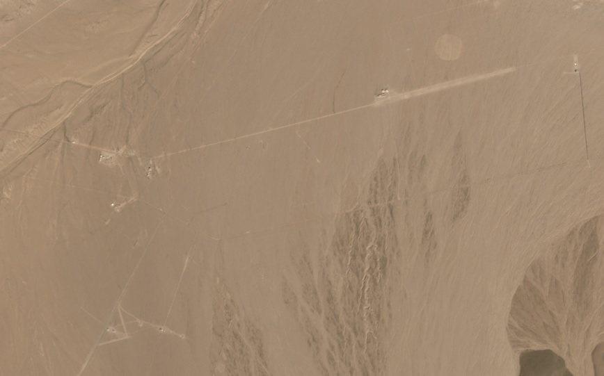
This image shows those coordinates as of yesterday afternoon.
What do you want me to zoom into?

I have access to daily satellite data.
This image shows those coordinates as of yesterday afternoon.
What do you want me to zoom into?
a reply to: Macenroe82
S.E. of dead center on that pic, there seems to be a facility of sorts. Perhaps there?
Interesting thread. Great birdseye pic too.
S.E. of dead center on that pic, there seems to be a facility of sorts. Perhaps there?
Interesting thread. Great birdseye pic too.
I have to split for about an hour to check on something.
Ill be back.
OP let me know if any of those sat screen grabs is what your wondering about.
Maybe circle exactly where and ill get more screens for ya guys.
Hell, ask me to check anywhere in the world if you want, ill do some satellite stalking for ya.
Ill be back.
OP let me know if any of those sat screen grabs is what your wondering about.
Maybe circle exactly where and ill get more screens for ya guys.
Hell, ask me to check anywhere in the world if you want, ill do some satellite stalking for ya.
Search nearby in google maps and there are mines all around. I assume it's a mine.
a reply to: Macenroe82
What can you do with them, infrared and other stuff? I'd like a full scan of the Dravo Dam in Gaffney SC. Especially the Island in the middle.
What can you do with them, infrared and other stuff? I'd like a full scan of the Dravo Dam in Gaffney SC. Especially the Island in the middle.
So yes sometime back I scoured this area on google earth and what not finding a strange what seemed like agriculture or farm area. It could have been
just that but it was very peculiar the shacks I saw ground level and almost hangar like strips without hangars.
The hangars would have been smaller than conceivably expected almost like very large parking spaces. Then you had the outpost shacks here and there.
This place ground level perspective and just above seemed to reek of military installation fudged for viewing.
Then you had roads or runways almost seemed to indicate airport strips for take off landing nearby.
Could this be an exchange area between air force and non terrestrial if I was to take a flying leap?
originally posted by: Macenroe82
a reply to: Gravelbone
here?
Close but more southeastern. I saw a faint outline of a square belt road and what looked to be a few buildings. I'm on my phone, so I'm limited in capacity, but I know what I see.
Thanks.
a reply to: BlackDog10
There are multiple ranges out there.
It's Desert Radio, which is part of the NTC for Fort Irwin.
www.edwards.af.mil...
There are multiple ranges out there.
It's Desert Radio, which is part of the NTC for Fort Irwin.
www.edwards.af.mil...
edit on 9/27/2018 by Zaphod58 because: (no reason given)
edit on 9/27/2018 by Zaphod58 because: (no reason given)
a reply to: humanoidlord
I have a subscription to sat data for monitoring the tailings dams at my mine site.
I always forget that I can look at just about any place in the world - with the exception of the north and south poles,
depending on the location, the imagery is updated multiple times a day.
Usually im just looking at my mine site and thats it.
But recently ive been putting eye balls on area 51, skin walker ranch...ex gfs houses...i mean... jk lol.
a reply to: Gravelbone
here?
If not, post a screen shot from your phone, that way I have an idea of the precise local.
here?
If not, post a screen shot from your phone, that way I have an idea of the precise local.
this area is inside Randsburg Wash test area and part of China Lake.
35°32'32.3"N 117°15'47.7"W looks to be one of the US or non US radar test sites in that area.
only one of the pads has a radar unit on it and under it is a large building with A/C for a lot of electronics.
35°30'19.02"N 117°20'47.10"W is Sea Site 1
35°24'0318"n 117°23.46"W use to be Sea Site 2 but has been shut down and the radars removed and i believe 35°32'32.3"N 117°15'47.7"W is the new Sea Site #3???.
a reply to: Macenroe82
damn, thats awesome, someone should make a public open source version of that
damn, thats awesome, someone should make a public open source version of that
a reply to: humanoidlord
If you have something of interest you want me to put some eyeballs on send me a PM with the cords.
If you have something of interest you want me to put some eyeballs on send me a PM with the cords.
Pulling it up on google earth loks like an abandoned reasearch facility can see several old trucks maybe 70's models. A rusted tower to the north. And
a few old planes maybe for either ground radar testing or bombing practice to the right along main road
new topics
-
George Knapp AMA on DI
Area 51 and other Facilities: 5 hours ago -
Not Aliens but a Nazi Occult Inspired and then Science Rendered Design.
Aliens and UFOs: 5 hours ago -
Louisiana Lawmakers Seek to Limit Public Access to Government Records
Political Issues: 7 hours ago -
The Tories may be wiped out after the Election - Serves them Right
Regional Politics: 8 hours ago -
So I saw about 30 UFOs in formation last night.
Aliens and UFOs: 10 hours ago -
Do we live in a simulation similar to The Matrix 1999?
ATS Skunk Works: 11 hours ago
top topics
-
BREAKING: O’Keefe Media Uncovers who is really running the White House
US Political Madness: 12 hours ago, 24 flags -
George Knapp AMA on DI
Area 51 and other Facilities: 5 hours ago, 19 flags -
Biden--My Uncle Was Eaten By Cannibals
US Political Madness: 13 hours ago, 18 flags -
Louisiana Lawmakers Seek to Limit Public Access to Government Records
Political Issues: 7 hours ago, 7 flags -
"We're All Hamas" Heard at Columbia University Protests
Social Issues and Civil Unrest: 13 hours ago, 7 flags -
Russian intelligence officer: explosions at defense factories in the USA and Wales may be sabotage
Weaponry: 17 hours ago, 6 flags -
So I saw about 30 UFOs in formation last night.
Aliens and UFOs: 10 hours ago, 5 flags -
The Tories may be wiped out after the Election - Serves them Right
Regional Politics: 8 hours ago, 3 flags -
Not Aliens but a Nazi Occult Inspired and then Science Rendered Design.
Aliens and UFOs: 5 hours ago, 3 flags -
Do we live in a simulation similar to The Matrix 1999?
ATS Skunk Works: 11 hours ago, 3 flags
active topics
-
Not Aliens but a Nazi Occult Inspired and then Science Rendered Design.
Aliens and UFOs • 8 • : theatreboy -
I Guess Cloud Seeding Works
Fragile Earth • 25 • : Degradation33 -
-@TH3WH17ERABB17- -Q- ---TIME TO SHOW THE WORLD--- -Part- --44--
Dissecting Disinformation • 534 • : cherokeetroy -
The US Supreme Court Appears to Side With the January 6th 2021 Capitol Protestors.
Political Conspiracies • 48 • : hoobah -
BREAKING: O’Keefe Media Uncovers who is really running the White House
US Political Madness • 11 • : BingoMcGoof -
Elites disapearing
Political Conspiracies • 28 • : hoobah -
African "Newcomers" Tell NYC They Don't Like the Free Food or Shelter They've Been Given
Social Issues and Civil Unrest • 14 • : GENERAL EYES -
God is watching.
Politicians & People • 28 • : glend -
George Knapp AMA on DI
Area 51 and other Facilities • 19 • : Brotherman -
It has begun... Iran begins attack on Israel, launches tons of drones towards the country
World War Three • 881 • : cherokeetroy