It looks like you're using an Ad Blocker.
Please white-list or disable AboveTopSecret.com in your ad-blocking tool.
Thank you.
Some features of ATS will be disabled while you continue to use an ad-blocker.

Mount Sharp on Mars - Covered with ice or has remains of a Glacier.
page: 3share:
originally posted by: wildespace
originally posted by: LookingAtMars
a reply to: wildespace
Doesn't look like ice to me at all, these are just lighter-coloured rocks and sediments.
Glad to see you are so informed and because it doesn't look like ice to you it must not be. Mars has dust that covers almost everything. Glad you know for a fact it is "just lighter-coloured rocks and sediments". It seems you don't even know what NASA says it is.
It's a case of pot calling kettle black here, since all you're saying is "it looks like ice to me, because that area looks brighter than the rest."
Mars has plenty of frozen CO2 in the polar regions, and it's not covered in dust. Why would the Gale crater "glacier" be? With CO2 ice, there are seasonal changes and sublimation events that produce dark spikes and other features. We don't see anything like that on Mt Sharp.
SNIP
Mars has plenty of frozen CO2 in the polar regions, and it's not covered in dust. Why would the Gale crater "glacier" be? With CO2 ice, there are seasonal changes and sublimation events that produce dark spikes and other features. We don't see anything like that on Mt Sharp.
You answer your own question there, LOL.
edit on 9/9/2018 by Blaine91555 because: Snipped for Manners Violation
a reply to: ArMaP
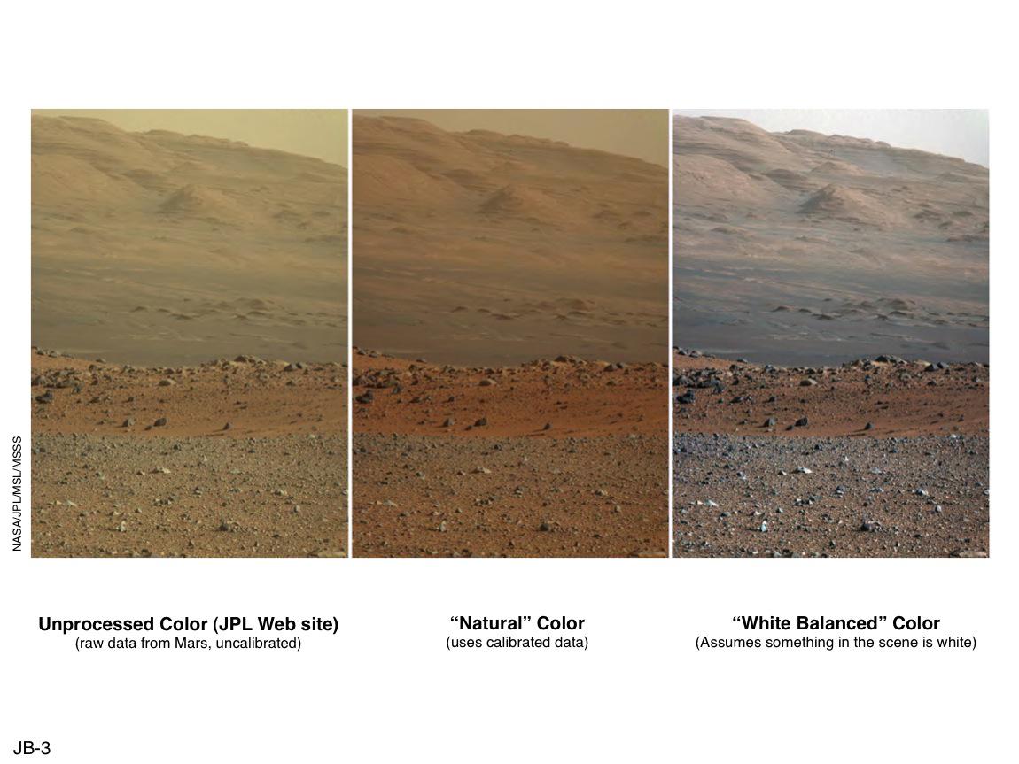
Exactly what I'm saying. A *naturally* occurring reddish image is going to look funky when color corrected.
What I'm barking about is when the sky is clear, about as blue as you can end up with, everything looks *great*- and the thing's been color corrected into the reds so far, it looks like it's been filmed thru a red filter!
a reply to: wildespace
Where is that image taken, a polar region I bet. Is MSL in a polar region? No, that's why they would try and keep it secret. This is the last question I answer because no one has answered my question and you are not looking for answers. SNIP
Where is that image taken, a polar region I bet. Is MSL in a polar region? No, that's why they would try and keep it secret. This is the last question I answer because no one has answered my question and you are not looking for answers. SNIP
edit on 9/9/2018 by Blaine91555 because: Snipped for Manners Violation
Mod Note:
Please knock off the tit for tat. If you are talking about each other and not the topic, you are off topic or worse.
Debate, even heated debate is allowed. This is a not a Blog its a discussion board. All points of view are allowed. Any attempts to control the conversation or drive away opposing opinions is against the T&C and can result in post removals or more.
Do not reply to this message.
originally posted by: LookingAtMars
a reply to: OneBigMonkeyToo
The point is that is not impossible for people to do it - the data are there and people can access them. The tools to process the data are freely available. Difficult is not impossible.
I didn't say it was impossible! I said they make it HARD!
"They" are not 'making' it hard. It is a complicated process by its very nature, not because someone has made it so on purpose. The data are there, and anyone who wished to put their mind to it can download and process them. You are implying that data are being hidden and obfuscated but have offered no proof that this is the case other than "it's a big download".
If 'they' really wanted to hide something you merely have pretty image galleries, not terabytes of image data available on demand, not websites where you could actually leave suggestions for them to consider when choosing photography sites.
originally posted by: LookingAtMars
Have you ever tried to download a MEX (for example) EDR and open it? I have, and can. First you have to download ISIS and set it up (used to be had to use LINUX). The ISIS download with data is like 100 gigs. Believe me the average person can not open an EDR.
That's what I use.

Edited to add that IMG files are also opened by NASAview, much easier to use and available for several operating systems (I use it in Windows).
edit on 9/9/2018 by ArMaP because: (no reason given)
originally posted by: LookingAtMars
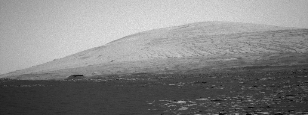
Why is that image so much brighter than the rest of the image. I am putting forth that is because it is ice. Not saying without a doubt, just it could be. Why do you think it is so much brighter?
At first I thought it was a question of how the Sun was shinning on the ground, coming from a direction that would make that area reflect more light (besides the fact that the material on the mount is not the same as that on the ground, the ground has a general darker tone and small rocks that help create a darker look, as they break the surface in small patches and avoid large refletive areas), but after looking at the image from the opening post converted from an IMG file available at pds-imaging.jpl.nasa.gov... (file NLB_535906505EDR_S0593016NCAM00569M1.IMG) I think it was more the way they applied too much contrast to the photo, which is not surprising, as from what I have see in all the years I have been looking at Mars photos, NASA likes to use too much contrast on the images they publish to the general public.
This photo was taken at 16:25:08.372 local mean solar time.
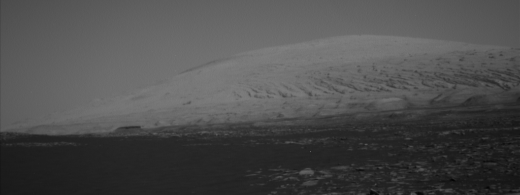
The next photo (file NLB_535890533EDR_S0593016NCAM00569M1.IMG) was taken from the same place, pointing in the same direction, but at a different time, 12:06:03.489 local mean solar time. We can see that there is a big difference in the way the light interacts with the ground.
I think the Sun's position also makes a difference.
I have been working with Mars images before the turn of the century. I know for a fact NASA holds back info.
I have only been looking at Mars photos since I joined this forum, in 2004. Can you tell us how you know that NASA holds back info and what kind of info it is? Or maybe that could be used for a new thread.
originally posted by: wylekat
There's genuine, red, dusty images of Mars, and then, there's the for some obscure reason, the faked, red images of Mars. I can figure out which is which by pulling on 2 sliders in temperature and tint- then watching what besides the sky turns weird colors- like the dirt or various rocks. I start getting greenish Martian fields, it's naturally reddish skies. I get the slightly off red, more dirt colors, and some multicolored rocks in the mix, it's been tinted. Plus- just by looking at it, and the whole thing is this uniform *red* color is a strong indicator...
Could you post some example? Now I'm curious about it.
If they added a tint to some photos wouldn't it work like a filter, resulting in an image that looks exactly like if it was taken during a sand storm?
originally posted by: LookingAtMars
ESA, LOL, NASA is much more open with their data than ESA. ESA can take years before they release their raw data.
Exactly, but that was not what we were talking about, was it? I was saying that ESA published information about the existence of water ice deposits and water vapour clouds on Mars years ago, so it's no secret.
originally posted by: wylekat
What I'm barking about is when the sky is clear, about as blue as you can end up with, everything looks *great*- and the thing's been color corrected into the reds so far, it looks like it's been filmed thru a red filter!
Sorry, I don't understand what you mean, could you rephrase it? Thanks in advance.
a reply to: ArMaP
The problem with NASA view is that is all you can do is look, and only 16 bit so you are missing image information. I have not used it in a very long time but doubt that has changed.
Edited to add that IMG files are also opened by NASAview, much easier to use
The problem with NASA view is that is all you can do is look, and only 16 bit so you are missing image information. I have not used it in a very long time but doubt that has changed.
originally posted by: wylekat
a reply to: ArMaP
Exactly what I'm saying. A *naturally* occurring reddish image is going to look funky when color corrected.
What I'm barking about is when the sky is clear, about as blue as you can end up with, everything looks *great*- and the thing's been color corrected into the reds so far, it looks like it's been filmed thru a red filter!
The martian sky is never clear. And even if it were for some periods, it wouldn't be blue either. There's so little atmosphere on Mars that the sky would look almost black, like in photos taken at high altitudes on earth.
Anyhoo, images coming from rovers are not colour-calibrated, so they have to be here on earth. Since the people who're running the mission know exactly how the cameras work, they know what kind of adjustments they need to make.
a reply to: ArMaP
I was talking about why Mount Sharp is so bright in this image. I do not think it could just be the contrast of the image but at least that was an answer. Why are almost all of the rocks at ground level not that bright also? Elevation does not affect contrast.
And what the brighter different looking material in this image is. Since we know Mars has ice, I said it could be a glacier. What do you think it is? Why does it look different, brighter and somewhat out of place?
Exactly, but that was not what we were talking about, was it?
I was talking about why Mount Sharp is so bright in this image. I do not think it could just be the contrast of the image but at least that was an answer. Why are almost all of the rocks at ground level not that bright also? Elevation does not affect contrast.
And what the brighter different looking material in this image is. Since we know Mars has ice, I said it could be a glacier. What do you think it is? Why does it look different, brighter and somewhat out of place?
originally posted by: LookingAtMars
a reply to: wildespace
This is the last question I answer because no one has answered my question and you are not looking for answers.
Which question? "Would NASA tell us if there were a glacier on Mt Sharp"? The answer is yes, absolutely. They told us about all other glaciers they found.
recent direct observations made by the SHARAD radar instrument on the Mars Reconnaissance Orbiter satellite have confirmed that at least some features are relatively pure ice, and thus, true glaciers.
Radar Sounding Evidence for Buried Glaciers in the Southern Mid-Latitudes of Mars
NASA even goes as far as pointing out such massive reserves of water and how they can a valuable resource for future human exploration: www.uahirise.org...
Seems like your argument has fallen into dust.
a reply to: ArMaP
Can you link to me where NASA or ESA published information about the existence of water ice deposits anywhere near this size, that is easily accessible and not at the polar regions?
ESA published information about the existence of water ice deposits and water vapour clouds on Mars years ago, so it's no secret.
Can you link to me where NASA or ESA published information about the existence of water ice deposits anywhere near this size, that is easily accessible and not at the polar regions?
edit on 9-9-2018 by LookingAtMars because: (no reason given)
a reply to: wildespace
It was not an argument. I think I covered the point I was trying to make above.
Seems like your argument has fallen into dust.
It was not an argument. I think I covered the point I was trying to make above.
edit on 9-9-2018 by LookingAtMars because: (no reason given)
originally posted by: LookingAtMars
a reply to: ArMaP
And what the brighter different looking material in this image is. Since we know Mars has ice, I said it could be a glacier. What do you think it is? Why does it look different, brighter and somewhat out of place?
Either lighter-toned rock, or lighter-toned dust covering the rock. Definitely doesn't look like a glacier to me.
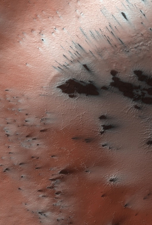
Here's a top-down view of that area (ESP_029034_1750):
For comparison, here's a picture of a real glacier on Mars (released by NASA):
originally posted by: LookingAtMars
a reply to: wildespace
Seems like your argument has fallen into dust.
It was not an argument. I think I covered the point I was trying to make above.
You're presenting two arguments in this thread:
#1 that there is a glacier on Mt Sharp, and
#2 that NASA are trying to hide that information from the public.
I refuted both of those arguments, with links and images. I'd like to see some research from you now: why do hold to those two arguments? Saying "that area looks out of place or too bright" or "NASA is afraid other countries will claim those resources" doesn't quite cut it, sorry.
edit on
9-9-2018 by wildespace because: (no reason given)
a reply to: wildespace
I think it does look like remains of a glacier that has been subliming away and is dust covered. Since no one seems to know, because it was not thrown back at me. I will tell you what NASA says it is, clay.
I think it does look like remains of a glacier that has been subliming away and is dust covered. Since no one seems to know, because it was not thrown back at me. I will tell you what NASA says it is, clay.
a reply to: wildespace
That is silly I said:
They were my thoughts put out to see what others thought. I would like to see $1,000,000 in my hand but won't get it
You're presenting two arguments in this thread: #1 that there is a glacier on Mt Sharp, and #2 that NASA are trying to hide that information from the public. I refuted both of those arguments, with links and images. I'd like to see some research from you now: why do hold to those two arguments? Saying "that area looks out of place or too bright" or "NASA is afraid other countries will claim those resources" doesn't quite cut it, sorry.
That is silly I said:
Looking at images of Mount Sharp on Mars, I get the impression it has remains of a Glacier and maybe is covered with ice.
The US does not want to let others know an easy source of clean water is available. NASA spent a lot of time and money to gain it's info and will not just give it away, so that China, Russia, India and others can start making plans to set up a base on Mars. If the fact that Mars is more Earth like than we are told got out, a lot of countries would make plans to go there.
They were my thoughts put out to see what others thought. I would like to see $1,000,000 in my hand but won't get it
edit on 9-9-2018 by LookingAtMars because: (no reason given)
new topics
-
Maestro Benedetto
Literature: 37 minutes ago -
Is AI Better Than the Hollywood Elite?
Movies: 46 minutes ago -
Las Vegas UFO Spotting Teen Traumatized by Demon Creature in Backyard
Aliens and UFOs: 4 hours ago -
2024 Pigeon Forge Rod Run - On the Strip (Video made for you)
Automotive Discussion: 5 hours ago -
Gaza Terrorists Attack US Humanitarian Pier During Construction
Middle East Issues: 5 hours ago -
The functionality of boldening and italics is clunky and no post char limit warning?
ATS Freshman's Forum: 6 hours ago -
Meadows, Giuliani Among 11 Indicted in Arizona in Latest 2020 Election Subversion Case
Mainstream News: 7 hours ago -
Massachusetts Drag Queen Leads Young Kids in Free Palestine Chant
Social Issues and Civil Unrest: 7 hours ago -
Weinstein's conviction overturned
Mainstream News: 8 hours ago -
Supreme Court Oral Arguments 4.25.2024 - Are PRESIDENTS IMMUNE From Later Being Prosecuted.
Above Politics: 10 hours ago
top topics
-
Krystalnacht on today's most elite Universities?
Social Issues and Civil Unrest: 10 hours ago, 9 flags -
Supreme Court Oral Arguments 4.25.2024 - Are PRESIDENTS IMMUNE From Later Being Prosecuted.
Above Politics: 10 hours ago, 8 flags -
Weinstein's conviction overturned
Mainstream News: 8 hours ago, 7 flags -
Gaza Terrorists Attack US Humanitarian Pier During Construction
Middle East Issues: 5 hours ago, 7 flags -
University of Texas Instantly Shuts Down Anti Israel Protests
Education and Media: 13 hours ago, 6 flags -
Massachusetts Drag Queen Leads Young Kids in Free Palestine Chant
Social Issues and Civil Unrest: 7 hours ago, 6 flags -
Meadows, Giuliani Among 11 Indicted in Arizona in Latest 2020 Election Subversion Case
Mainstream News: 7 hours ago, 5 flags -
Las Vegas UFO Spotting Teen Traumatized by Demon Creature in Backyard
Aliens and UFOs: 4 hours ago, 3 flags -
2024 Pigeon Forge Rod Run - On the Strip (Video made for you)
Automotive Discussion: 5 hours ago, 2 flags -
Any one suspicious of fever promotions events, major investor Goldman Sachs card only.
The Gray Area: 15 hours ago, 2 flags
active topics
-
University of Texas Instantly Shuts Down Anti Israel Protests
Education and Media • 222 • : cherokeetroy -
VP's Secret Service agent brawls with other agents at Andrews
Mainstream News • 58 • : CarlLaFong -
SETI chief says US has no evidence for alien technology. 'And we never have'
Aliens and UFOs • 72 • : yuppa -
My Poor Avocado Plant.
General Chit Chat • 77 • : JonnyC555 -
New whistleblower Jason Sands speaks on Twitter Spaces last night.
Aliens and UFOs • 61 • : Ophiuchus1 -
Is AI Better Than the Hollywood Elite?
Movies • 2 • : 5thHead -
Gaza Terrorists Attack US Humanitarian Pier During Construction
Middle East Issues • 25 • : CarlLaFong -
Mood Music Part VI
Music • 3102 • : Hellmutt -
Las Vegas UFO Spotting Teen Traumatized by Demon Creature in Backyard
Aliens and UFOs • 9 • : Ophiuchus1 -
British TV Presenter Refuses To Use Guest's Preferred Pronouns
Education and Media • 164 • : Annee