It looks like you're using an Ad Blocker.
Please white-list or disable AboveTopSecret.com in your ad-blocking tool.
Thank you.
Some features of ATS will be disabled while you continue to use an ad-blocker.

Is the Richat Structure, the Eye of Sahara, the remains of Atlantis
page: 9share:
originally posted by: Byrd
originally posted by: LABTECH767
a reply to: Byrd
To be fair though his idea is intriguing AND it is not really his idea he has just resurrected someone else earlier idea and repackaged it for his book and he seems to think continent's can move very fast indeed which I think not or they would merely crumple into themselves becoming concertinaed by such movement but hey I am no geology expert or anything.
Ah yes, that "swiftly moving continents." You're right - that doesn't happen. Continents aren't thin layers of soil floating on an easily pushed platform. Rapid movement of continents is in the realm of inches per year (and not a lot of inches, either.) The force needed to displace a continent by hundreds of miles in a short time (shorter than a human lifetime) would crack the Earth... and nothing would survive that.
I saw a calculation once that the old Pyramid of Giza which riding atop the African Plate's speed is about 2.15 cm (0.85 in) per year. It has been moving over the past 100 million years or so in a general northeast direction. These means the good old pyramid has move quite a bit. Hmmmm that means its moved north east some 100 meters since construction - kinda throws out all the old 'accuracy' claims for its location on Earth.
hypertextbook.com...
Estimates vary of course.
Kinda blows up the 'speed of light in meters claim too'.
originally posted by: Hanslune
originally posted by: Byrd
originally posted by: LABTECH767
a reply to: Byrd
To be fair though his idea is intriguing AND it is not really his idea he has just resurrected someone else earlier idea and repackaged it for his book and he seems to think continent's can move very fast indeed which I think not or they would merely crumple into themselves becoming concertinaed by such movement but hey I am no geology expert or anything.
Ah yes, that "swiftly moving continents." You're right - that doesn't happen. Continents aren't thin layers of soil floating on an easily pushed platform. Rapid movement of continents is in the realm of inches per year (and not a lot of inches, either.) The force needed to displace a continent by hundreds of miles in a short time (shorter than a human lifetime) would crack the Earth... and nothing would survive that.
I saw a calculation once that the old Pyramid of Giza which riding atop the African Plate's speed is about 2.15 cm (0.85 in) per year. It has been moving over the past 100 million years or so in a general northeast direction. These means the good old pyramid has move quite a bit. Hmmmm that means its moved north east some 100 meters since construction - kinda throws out all the old 'accuracy' claims for its location on Earth.
hypertextbook.com...
Estimates vary of course.
Kinda blows up the 'speed of light in meters claim too'.
Ah, that's quite interesting. For those of you who want to see this (visually) here's a link to a map of the plate and an indicator showing its movement.
Good to know... good to know.
a reply to: Hanslune
In fairness, some plates move faster at certain points. For example, it is postulated that the Indian plate travelled over a hotspot which sent it flying into the Eurasian plate which is why the Himalayas are so tall. They think it may have reached a dizzying speed of............several metres per year.
Bah to your pesky centimetres, i raise you a couple of metres top speed!
originally posted by: Flavian
a reply to: Hanslune
In fairness, some plates move faster at certain points. For example, it is postulated that the Indian plate travelled over a hotspot which sent it flying into the Eurasian plate which is why the Himalayas are so tall. They think it may have reached a dizzying speed of............several metres per year.
Bah to your pesky centimetres, i raise you a couple of metres top speed!
As the chart shows the different plates move at different speeds - and parts of some plates move at different rates than other parts - which is causing the eastern part of the African plate to tear - creating the rift valley in central Africa.
I scoff at your mere metres and double down with super duper 'skipping' meters.
originally posted by: Hanslune
Hmmmm that means its moved north east some 100 meters since construction - kinda throws out all the old 'accuracy' claims for its location on Earth.
Yeah, that part has always bugged me. Celestial alignments attributed to buildings said to be super ancient. The earth is not a stable, immobile platform anywhere. And if it lines up with a particular sunrise or star rise that matches up with what it is today, then it's probably not all that ancient because as big as it may be, it moved over time. Unless they built it to coincide with the end of the world, or the return of the gods or something. Meaning now. But you don't see that.
originally posted by: Blue Shift
originally posted by: Hanslune
Hmmmm that means its moved north east some 100 meters since construction - kinda throws out all the old 'accuracy' claims for its location on Earth.
Yeah, that part has always bugged me. Celestial alignments attributed to buildings said to be super ancient. The earth is not a stable, immobile platform anywhere. And if it lines up with a particular sunrise or star rise that matches up with what it is today, then it's probably not all that ancient because as big as it may be, it moved over time. Unless they built it to coincide with the end of the world, or the return of the gods or something. Meaning now. But you don't see that.
Well yeah the world's surface is not only moving but the earth wobbles also causing chaos in all such predictions.
originally posted by: Hanslune
Well yeah the world's surface is not only moving but the earth wobbles also causing chaos in all such predictions.
Also, it's not like the buildings themselves move and tilt to highlight just one star that happens to come up on a horizon in one spot. Every window or doorway to the sky traces an arc across the entire sky from horizon to horizon. Since there are more than a few stars in the sky, the likelihood of lining up with an "important" one is probably pretty good.
originally posted by: Blue Shift
originally posted by: Hanslune
Well yeah the world's surface is not only moving but the earth wobbles also causing chaos in all such predictions.
Also, it's not like the buildings themselves move and tilt to highlight just one star that happens to come up on a horizon in one spot. Every window or doorway to the sky traces an arc across the entire sky from horizon to horizon. Since there are more than a few stars in the sky, the likelihood of lining up with an "important" one is probably pretty good.
Yep if you wait long enough something will line up with something else.
originally posted by: Byrd
Uhm.... nope. Here's a single Powerpoint slide that shows the separation of the continents over millions of years Spain was actually connected to Africa at one time and to one edge of northeast Canada.
(nice image of the Atlantic Seabed here, if anyone wants a refresher]
To be fair I question the detail of that continental drift map since it's lacking well... spain... in the present day map (and also UK, Italy and every island in existance etc) :p
It has nothing to do with Pangea and obviously such an upheaval would have happened much more recently, which was the point of the theory (and you could link it with even the flooding of the Sahara, the biblical flood etc if it totally messed up the med). But granted, I think it would have left more noticable geological evidance.
edit on 28-11-2018 by merka because: (no reason given)
originally posted by: merka
(nice image of the Atlantic Seabed here, if anyone wants a refresher]
To be fair I question the detail of that continental drift map since it's lacking well... spain... in the present day map (and also UK, Italy and every island in existance etc) :p
It has nothing to do with Pangea and obviously such an upheaval would have happened much more recently, which was the point of the theory (and you could link it with even the flooding of the Sahara, the biblical flood etc if it totally messed up the med). But granted, I think it would have left more noticable geological evidance.
Here's a more detailed map
cdn.britannica.com...
And two animated ones
www.britannica.com...
www.britannica.com...
edit on 28/11/18 by Hanslune because: (no reason given)
Jimmy’s got a new video. In short, it’s about the Greenland comet catastrophe. Which transpired in the younger dryas time period. Could explain
the massive scarring around the Richat and many other areas.
m.youtube.com...
m.youtube.com...
I've found a few interesting ancient maps that show the Richat Structure with water and rivers flowing that I havent seen anyone cover yet! I made a
new YT channel recently and my latest video is comparing Plato's texts in more detail with the Richat Structure showing a few possible new
correlations too. I'm sorry for the small plug but if anyone is interested in my content I'd appreciate the subscription thank you
youtu.be...
youtu.be...
a reply to: VirtualParadise
Really well done! I enjoyed the vid.
Really well done! I enjoyed the vid.
edit on 2-1-2019 by StallionDuck because: (no reason given)
originally posted by: VirtualParadise
I've found a few interesting ancient maps that show the Richat Structure with water and rivers flowing that I havent seen anyone cover yet! I made a new YT channel recently and my latest video is comparing Plato's texts in more detail with the Richat Structure showing a few possible new correlations too. I'm sorry for the small plug but if anyone is interested in my content I'd appreciate the subscription thank you
youtu.be...
You'll have to place the Richat Structure 185 meters from the Atlantic Ocean to interest me.
This, according to Plato, the only ancient source.
Harte
So, let me get this straight.
The richat structure is the Island atlantis, even though it is 360 miles from the coast and at an elevation of ~1800'.
And even though we can find evidence of Homo erectus( ample and mapped finds of tools and debitage) having lived in and used the structure for materials we canmysteriously not find a single trace of even a small viliage anywhere within the structure??????????
And somehow these intrusive siliacious rock dikes that are not contiguous and on the surface of this huge dome formed canals for ships to travel in even though they would hold no water.
edit on p0000001k19132019Wed, 02 Jan 2019 17:19:18 -0600k by punkinworks10 because: (no reason given)
a reply to: Harte
Could it not be possible that at 11,800 BC (approx younger dryas) that this area was indeed 185m from the sea??
www.theguardian.com...
This for example suggest a huge under ground river directly beneath the Richat..... Could this be the river shown on ancient maps sunk under the sands???... Was the Richat at a river delta of kinds??....
And didn't Plato say the area was now impassable due to mud???? (wheres the sahara ocean gone?? why are there whale and fish "bones" in the area up until the cliffs outside oudanne?? - findingatlantis.com - what is that huge "slide" of mud running from the Richat to the Atlantic that can be seen on google earth?)
I'm all for science but surely we should examine all the evidence rather than looking at a globe today and suggesting the face of the earth hasn't changed in 14,000 years??
Just thought provoking, thats all.... first post and love all of your and everyone's work and opinions here!!
edit on 3-1-2019 by lee54321
because: date changes
originally posted by: Harte
originally posted by: lee54321
a reply to: Harte
Could it not be possible that at 11,800 BC (approx younger dryas) that this area was indeed 185m from the sea??
Nope.
Harte
May I please ask your opinion on the Green Sahara Hypothesis??
edit on 3-1-2019 by lee54321 because: got excited and forgot my
manners
originally posted by: lee54321
originally posted by: Harte
originally posted by: lee54321
a reply to: Harte
Could it not be possible that at 11,800 BC (approx younger dryas) that this area was indeed 185m from the sea??
Nope.
Harte
May I please ask your opinion on the Green Sahara Hypothesis??
It's not an hypothesis as far as I'm concerned.
Unless you're talking about something entirely different that the current model of the Sahara having previously fluctuated between monsoons and dry periods.
None of that is within Plato's time frame for Atlantis though.
Harte
a reply to: lee54321
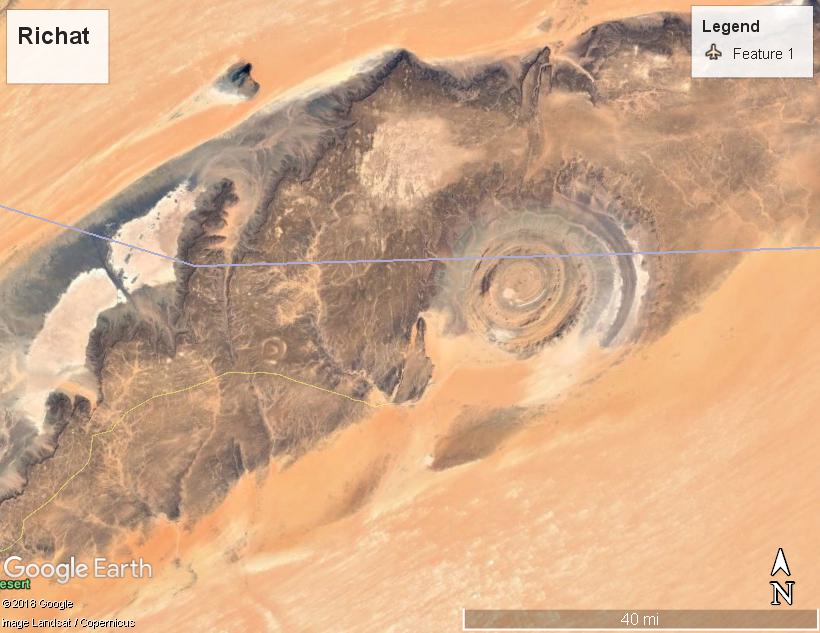
What part of 360 miles from the ocean is not understandable.
That ""slide" of mud" is a series on ridges 1200-1500' high and the fish and whale bones are called FOSSILS and are millions of years old.
Could it not be possible that at 11,800 BC (approx younger dryas) that this area was indeed 185m from the sea??
What part of 360 miles from the ocean is not understandable.
And didn't Plato say the area was now impassable due to mud???? (wheres the sahara ocean gone?? why are there whale and fish "bones" in the area up until the cliffs outside oudanne?? - findingatlantis.com - what is that huge "slide" of mud running from the Richat to the Atlantic that can be seen on google earth?)
That ""slide" of mud" is a series on ridges 1200-1500' high and the fish and whale bones are called FOSSILS and are millions of years old.
new topics
-
Former Labour minister Frank Field dies aged 81
People: 1 hours ago -
SETI chief says US has no evidence for alien technology. 'And we never have'
Aliens and UFOs: 2 hours ago -
This is our Story
General Entertainment: 5 hours ago -
President BIDEN Vows to Make Americans Pay More Federal Taxes in 2025 - Political Suicide.
2024 Elections: 7 hours ago -
Ode to Artemis
General Chit Chat: 8 hours ago
top topics
-
University student disciplined after saying veganism is wrong and gender fluidity is stupid
Education and Media: 16 hours ago, 14 flags -
President BIDEN Vows to Make Americans Pay More Federal Taxes in 2025 - Political Suicide.
2024 Elections: 7 hours ago, 12 flags -
One Flame Throwing Robot Dog for Christmas Please!
Weaponry: 12 hours ago, 6 flags -
Should Biden Replace Harris With AOC On the 2024 Democrat Ticket?
2024 Elections: 14 hours ago, 6 flags -
SETI chief says US has no evidence for alien technology. 'And we never have'
Aliens and UFOs: 2 hours ago, 4 flags -
Don't take advantage of people just because it seems easy it will backfire
Rant: 12 hours ago, 4 flags -
Ditching physical money
History: 12 hours ago, 4 flags -
Ode to Artemis
General Chit Chat: 8 hours ago, 3 flags -
God lived as a Devil Dog.
Short Stories: 17 hours ago, 3 flags -
Former Labour minister Frank Field dies aged 81
People: 1 hours ago, 3 flags
active topics
-
President BIDEN Vows to Make Americans Pay More Federal Taxes in 2025 - Political Suicide.
2024 Elections • 10 • : pianopraze -
Thousands Of Young Ukrainian Men Trying To Flee The Country To Avoid Conscription And The War
Other Current Events • 126 • : Xtrozero -
whistleblower Captain Bill Uhouse on the Kingman UFO recovery
Aliens and UFOs • 18 • : Jukiodone -
University student disciplined after saying veganism is wrong and gender fluidity is stupid
Education and Media • 38 • : Consvoli -
One Flame Throwing Robot Dog for Christmas Please!
Weaponry • 9 • : crayzeed -
So this is what Hamas considers 'freedom fighting' ...
War On Terrorism • 230 • : FlyersFan -
SETI chief says US has no evidence for alien technology. 'And we never have'
Aliens and UFOs • 18 • : Consvoli -
The Reality of the Laser
Military Projects • 34 • : Zaphod58 -
Remember These Attacks When President Trump 2.0 Retribution-Justice Commences.
2024 Elections • 52 • : TzarChasm -
Ditching physical money
History • 15 • : crayzeed