It looks like you're using an Ad Blocker.
Please white-list or disable AboveTopSecret.com in your ad-blocking tool.
Thank you.
Some features of ATS will be disabled while you continue to use an ad-blocker.

The Soviets’ secret map of Seattle tells a lot about us
page: 125
share:
I know that you have not heard enough about the Russians lately, so let's dredge up some stuff from the Cold War! The map has certain locations
marked as points of interest, but the descriptions of the places don't match what was there at the time. Or did they?
SEATTLE TIMES SOURCE
Please read the SOURCE ARTICLE to find out more!
Прощай
SEATTLE TIMES SOURCE
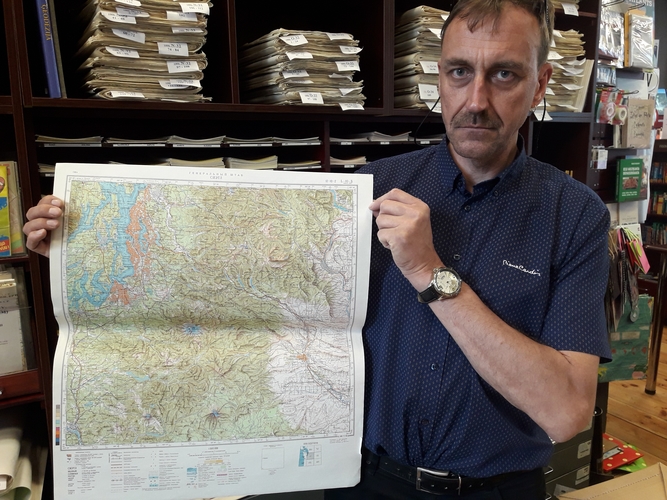
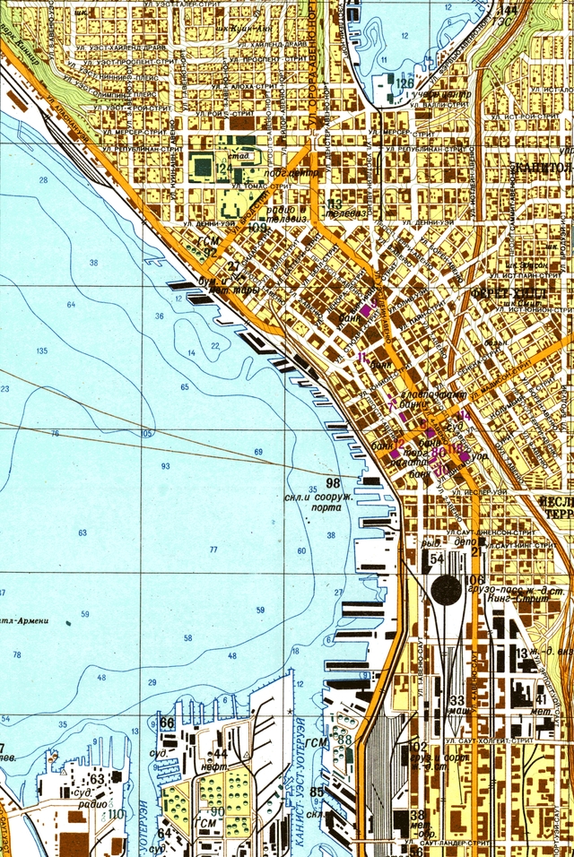
This 1976 map of Seattle is not the kind you would have bought at a gas station. No, this is a secret map put together by the Military Topographic Directorate of the General Staff of the Soviet Army. The Union of Soviet Socialist Republics (U.S.S.R.) was fond of terms like “directorate.”
This map was part of a massive Cold War effort by the Soviets. Over five decades — beginning with World War II until the Soviet Union collapsed in 1991 — it produced more than a million detailed maps of cities and places around the world.
You could call the secret 1976 map “the Soviet of Seattle,” a not-so-joking reference to the “Soviet of Washington” title reflecting this state’s (meaning Seattle’s) lefty politics as distinguished from the rest of the United States.
The Seattle map marks one spot, No. 29, on the shores of Salmon Bay in Ballard, as “Explosion mechanisms and radio electronic devices.” An accompanying text says there is a factory there that produces “explosive devices for nuclear arms.”
No. 29 is placed where 24th Avenue Northwest dead-ends at the bay, now the location of the Stimson Marina. What did the Soviets know? Tom Bayley, president of C.D. Stimson, has a guess. “The Honeywell marine division pretty much occupied that whole property back in the day,” he says. “Who knows what they were building?” A May 4, 1983, Seattle Times story about Honeywell Marine Systems Division moving from Ballard to the Mukilteo area says the company is a prime contractor for the U.S. Navy’s lightweight torpedoes, working on homing systems. The work was important enough that the facility had “to maintain security,” the story says.
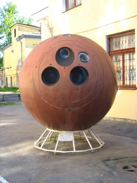
The re-entry sphere, with camera ports, from the Zenit spy satellite that the Soviets began using in the early 1960s to photograph various locations — maybe even Seattle. The sphere now is a tourist attraction at the Russian.
Then there is the astonishing No. 26 on the Bellevue portion of the map, bounded by Bellevue Way Northeast to the west, Northeast Sixth Street to the north, 108th Avenue Northeast to the east, and Northeast Fourth Street to the south. It’s abbreviated as “atom,” most likely an adjective, which, depending on the noun it went with, could stand for factory, lab or plant, explains Professor Galya Diment, a native Russian speaker with the University of Washington’s Slavic Languages & Literatures department. She translated portions of the “spravka,” text accompanying the map. It says No. 26 is a “nuclear factory which produces nuclear fuel.”
Please read the SOURCE ARTICLE to find out more!
Прощай
edit on 6152018 by seattlerat because: (no reason given)
The Russians are the Russians, both good and bad, it looks like a map from a old KGB source for action to be taken.
a reply to: seattlerat
Really cool story, thank you for posting this...I imagine they and others have similar maps for the entire country.
Really cool story, thank you for posting this...I imagine they and others have similar maps for the entire country.
edit on 15-6-2018 by
BlueJacket because: (no reason given)
A million maps! Nowadays they just need to go on Google..
edit on 15/6/18 by Misterlondon because: (no reason given)
originally posted by: Misterlondon
A million maps! Nowadays they just need to go on Google..
But Google Maps isn't going to tell you that the weapons-grade nerve gas we officially don't have is being stored in the ordinary-looking house just down the block from you.
a reply to: seattlerat
Apparently much of the information on the map(s) was obtained by spies within the United States. According to the source material some witnesses that had worked at some of those places vouch for the accuracy of some of the secret information on that Seattle map.
I would love to see some original photos taken by those Russian spy satellites that were used in that old mapping program. I bet they were quite crude and I imagine it took some considerable skill and a massive budget to come up with such beautifully detailed maps.
Very cool story, brings back oddly nostalgic memories of hiding under my desk at school for bombing drills.
a reply to: seattlerat
Absolutely wrong. The word "soviet" means "congress." The Washington Soviet would mean the Washington Statehouse.
You could call the secret 1976 map “the Soviet of Seattle,” a not-so-joking reference to the “Soviet of Washington” title reflecting this state’s (meaning Seattle’s) lefty politics as distinguished from the rest of the United States.
Absolutely wrong. The word "soviet" means "congress." The Washington Soviet would mean the Washington Statehouse.
originally posted by: DJW001
a reply to: seattlerat
You could call the secret 1976 map “the Soviet of Seattle,” a not-so-joking reference to the “Soviet of Washington” title reflecting this state’s (meaning Seattle’s) lefty politics as distinguished from the rest of the United States.
Absolutely wrong. The word "soviet" means "congress." The Washington Soviet would mean the Washington Statehouse.
You mean, the Soviet of Washington would mean the Statehouse of Washington, don't you? Nobody ever said "the Washington Soviet".
Maybe you were thinking in your native Russian and got your wires crossed?
Also, you said it means Congress. So which is it, "congress" or "statehouse"?
edit on 6/16/2018 by 3n19m470 because: (no reason
given)
Also, here is this in case you did not look at every link within every link like I did 😜
Communism made a larger impact on Washington than almost any other state. “There are forty-seven states in the Union, and the Soviet of Washington,” Postmaster General James Farley joked in 1936. The remark, for all its exaggeration, had some foundation.
edit on 6/16/2018 by 3n19m470 because: (no reason given)
a reply to: seattlerat
Thank you for sharing this. This is fantastic. I kind of like living in the Soviet America. It feels dangerous, sexy, exotic, adventurous, like anything could happen... Hmmm is that guy over there a spy? Probably. That's just how it is living in Soviet Washington.
That's why I never leave home without my poisonous dart firing wristwatch. It keeps me safe from all the Soviet spies. I actually fired the dart it came with a long time ago when I wanted to kill a spider on my ceiling but was too lazy to get up. I never could find the dart, and the company that makes them went out of business when the cold war ended, so it's basically impossible to buy a refill...
However, the chronometer is quite useful for ensuring that I do not miss the train, which would result in me losing my job, which would result in me being evicted, which would result in me being homeless... I heard that a lot of so called homeless are actually Soviet spies, and that is a world I do not want to be involved in.
Such is life in Soviet Washington, which is why I never leave home without my poison dart firing wristwatch, in order to protect me from the Russian Spies.
edit on 6/16/2018 by 3n19m470 because: (no reason given)
new topics
-
How does my computer know
Education and Media: 2 hours ago -
USO 10 miles west of caladesi island, Clearwater beach Florida
Aliens and UFOs: 6 hours ago
top topics
-
Running Through Idiot Protestors Who Block The Road
Rant: 17 hours ago, 12 flags -
Tesla cutting 14,000 jobs
Global Meltdown: 15 hours ago, 6 flags -
Israel ufo shoot down drones?
Aliens and UFOs: 15 hours ago, 6 flags -
USO 10 miles west of caladesi island, Clearwater beach Florida
Aliens and UFOs: 6 hours ago, 6 flags -
Abortions in first 12 weeks should be legalised in Germany, commission says
Medical Issues & Conspiracies: 15 hours ago, 5 flags -
On this Day in History, April 15, 1865, Abraham Lincoln Passed Away.
General Chit Chat: 15 hours ago, 4 flags -
How does my computer know
Education and Media: 2 hours ago, 0 flags
active topics
-
Report March 2024 - Underwater UFOs display capability that ‘jeopardizes US maritime security,’
Aliens and UFOs • 20 • : ARM19688 -
Putin Compares Himself to Jesus Promoting Traditional Values Against the Satanic West
Mainstream News • 66 • : whereislogic -
Negotiations and Diplomacy.
History • 10 • : chr0naut -
Israel ufo shoot down drones?
Aliens and UFOs • 18 • : TheMisguidedAngel -
How does my computer know
Education and Media • 2 • : chr0naut -
Afterlife, unknown, so prepare, or just go into the unknown (bad)!!
ATS Skunk Works • 50 • : Terpene -
Abortions in first 12 weeks should be legalised in Germany, commission says
Medical Issues & Conspiracies • 10 • : Freeborn -
President BIDEN Warned IRAN Not to Attack ISRAEL - Iran Responded with a Military Attack on Israel.
World War Three • 38 • : TinfoilTophat -
Canadian Police Urge Citizens To Avoid Conflict With Armed Robbers By Leaving Keys At Front Door
Social Issues and Civil Unrest • 68 • : Astyanax -
Gold and silver prices....woo hoo
History • 71 • : SchrodingersRat
25