It looks like you're using an Ad Blocker.
Please white-list or disable AboveTopSecret.com in your ad-blocking tool.
Thank you.
Some features of ATS will be disabled while you continue to use an ad-blocker.

Nellis range cellular coverage 11/2017
page: 13
share:
If you drive around the Nellis range, you probably know cellular coverage is poor. If only the cattle were smart phone users, then there would be a
decent customer base to support more towers.
I have Tmobile and AT&T service. Verizon is generally better in rural areas. Be that as it may, these photos document some of the AT&T coverage.
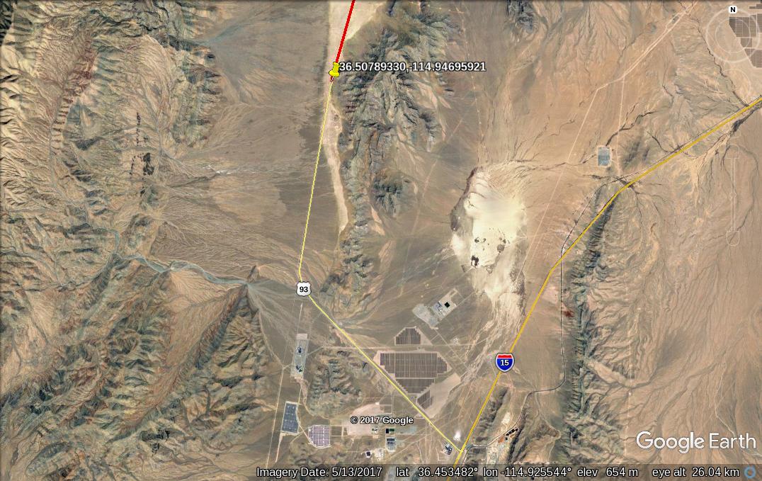
The first photo shows where my phone switches from Tmobile to AT&T. The waypoint is 36.50789330,-114.94695921.
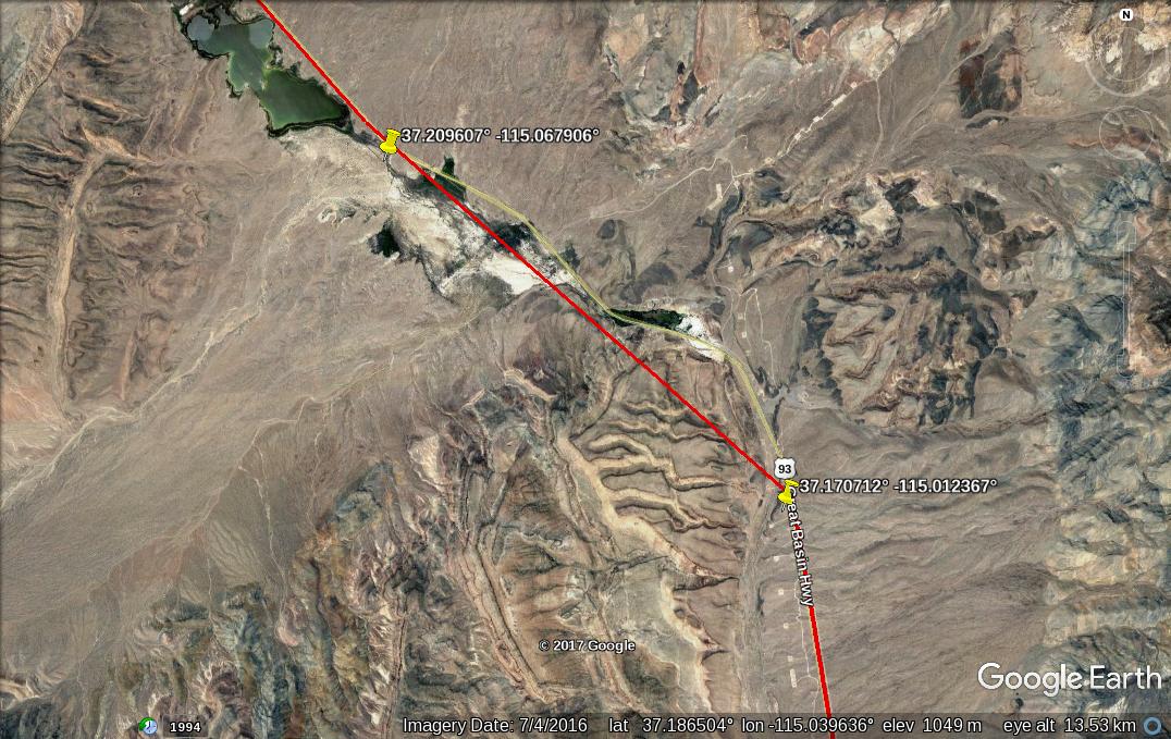
The straight portion here is where I couldn't receive AT&T. When the trail follows the road, I have coverage. The waypoints are 37.170712° -115.012367° and 37.209607° -115.067906°.
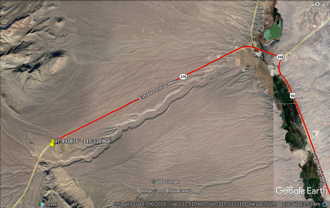
This is where AT&T ends. The waypoint is 37.493871° -115.331968°
AT&T works (just barely) on Tikaboo Peak.
I have some data on USA Commnet, which has a Warm Springs cell site. That will be uploaded later.
I have Tmobile and AT&T service. Verizon is generally better in rural areas. Be that as it may, these photos document some of the AT&T coverage.
The first photo shows where my phone switches from Tmobile to AT&T. The waypoint is 36.50789330,-114.94695921.
The straight portion here is where I couldn't receive AT&T. When the trail follows the road, I have coverage. The waypoints are 37.170712° -115.012367° and 37.209607° -115.067906°.
This is where AT&T ends. The waypoint is 37.493871° -115.331968°
AT&T works (just barely) on Tikaboo Peak.
I have some data on USA Commnet, which has a Warm Springs cell site. That will be uploaded later.
edit on 6-12-2017 by gariac because: added
waypoints since the photos are hard to read
Wilson Amplifiers are your friend. They work with every carrier.
originally posted by: SR1TX
Wilson Amplifiers are your friend. They work with every carrier.
ty for that info. im currently going to be moving to a rural area in the next couple months or so and service is very sketchy on this property. so u just saved me from having to hike 2.3 miles to the top of a ridge to hopefully get a reliable signal
edit on 6-12-2017 by TheScale because: (no
reason given)
a reply to: TheScale
I own an ISP that provides rural internet, in Texas. It helps to know these things. Otherwise you could end up with.....Satellite ...O_O
Depending on the SQ ft of home, relative distance to tower, will determine which one you need. I'm not an engineer or good at math, I just look at the providers coverage map and take a guess based on cell tower location, sector direction, and size of home/how many rooms do you want to cover.
I love my company, I love Wireless Fidelity, it's amazing.
a reply to: TheScale
I suggest a LTE gateway rather than an amplifier. You can use high gain antennas on the gateway if you want. The nice thing about an LTE gateway is you get ethernet output. They look like modem/router combos. Also wifi depending on the model. A LTE gateway, not being next to your head, can use more power and also can have larger antennas.
I detest Comcast and DSL is too slow at my house, so I use an LTE gateway at home, even though I do have wired internet choices. Google the 4G Antenna Shop. They sell gateways and resell Tmobile.
Note that UMTS and LTE have a range limited by timing. It is a matter of how the cell is provisioned. You could do 100km on LTE if they set it up that way. GSM was the worst. It has a strict 35km limit due to timing.
If you climb hills around the range, you can often sniff a cell tower and get reasonable signal strength., but you won't connect due to timing limitations.
Tmobile has a 600MHz (band 71) license in Central Nevada. Time will tell if they actually build out the network. Most of the area doesn't have fiber, which you need for the backhaul. That is why you see microwave dishes on the cell towers.
One of the problems with cellular in Central Nevada are the (greedy*) license holders. Verizon in Lincoln County is actually on the Wue license. Verizon bought Alltel, which is what you get along route 95 (I think). That was a $28 billion deal, and the network was junk. Verizon wanted the spectrum.
Those new power lines have fiber optic cable in the ground wire. Power utilities have done this for years, though most of the fiber is dark.
* of course I would be just as greedy if I held the license
a reply to: gariac
Lol wtf.
Me thinks you don't know what you are saying.
An LTE gateway (Modem) is not going to replace an amplifier. the Amplifier is what provides the LTE Gateway (Modem) the Energy necessary to communicate back to a tower some distance away. It does nothing by itself.
Lol wtf.
Me thinks you don't know what you are saying.
An LTE gateway (Modem) is not going to replace an amplifier. the Amplifier is what provides the LTE Gateway (Modem) the Energy necessary to communicate back to a tower some distance away. It does nothing by itself.
originally posted by: SR1TX
a reply to: gariac
Lol wtf.
Me thinks you don't know what you are saying.
An LTE gateway (Modem) is not going to replace an amplifier. the Amplifier is what provides the LTE Gateway (Modem) the Energy necessary to communicate back to a tower some distance away. It does nothing by itself.
The LTE gateway is like a cell phone on steroids. It has larger antennas, can accept external high gain antennas, and has more power than a cell phone.
The 4G Antenna Shop specializes in rural cellular service. To be fair, AT&T provides a similar service call "fixed wireless". My LTE gateway works with both Tmo and AT&T Sims. I've used it on the road where reception is poor.
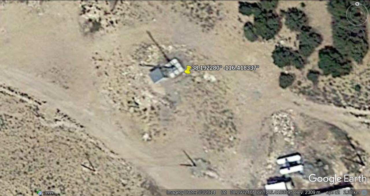
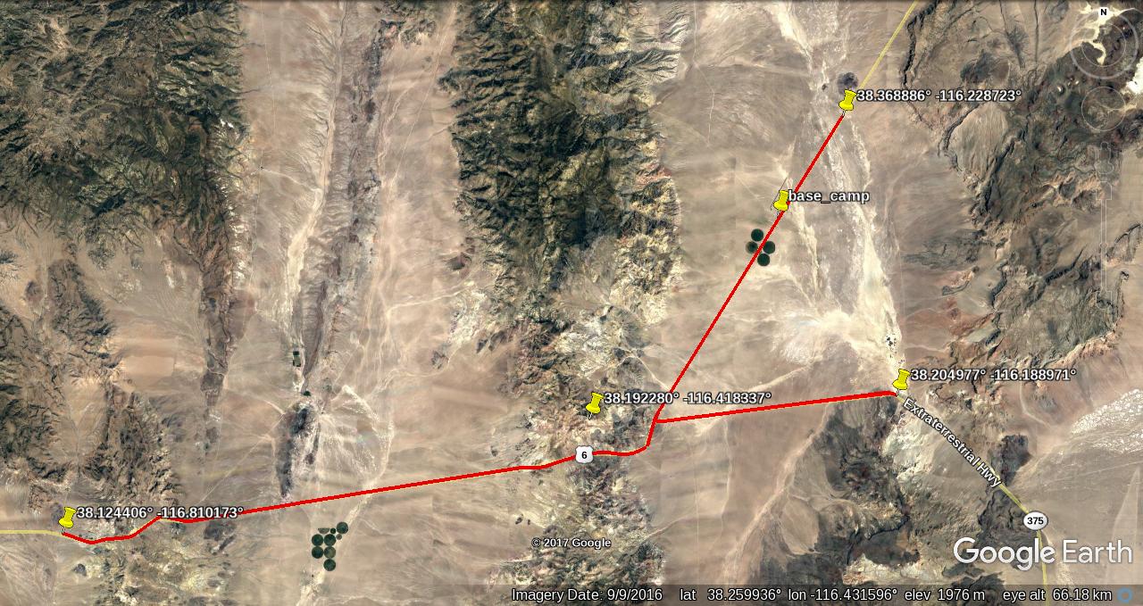
Warm Springs cell site
Warm Springs overall
Warm Springs southern limit
Warm Springs western limit
Warm Springs eastern limit
The Warm Springs cell site is supposedly both Verizon compatible (CDMA?) and GSM (in this case UMTS). I have no way to tell if it actually works with Verizon phones. USA Commnet is a roaming partner of Tmobile. The bandwidth is virtally zero, basically good enough for email.
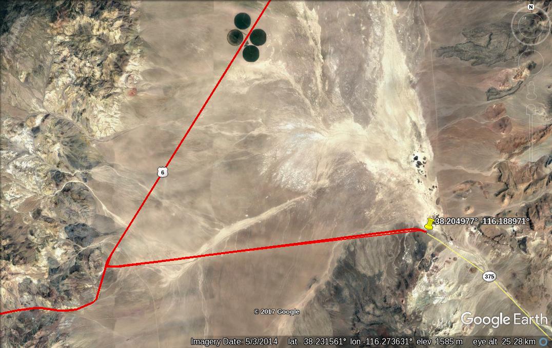
The western limit falls just short of the roadside rest. If you are familiar with the terrain, this makes sense. This is the rest stop that has a distant view of the Tonopah Test Range. Good enogh for scanning. I doubt you would see anything happening at the base.
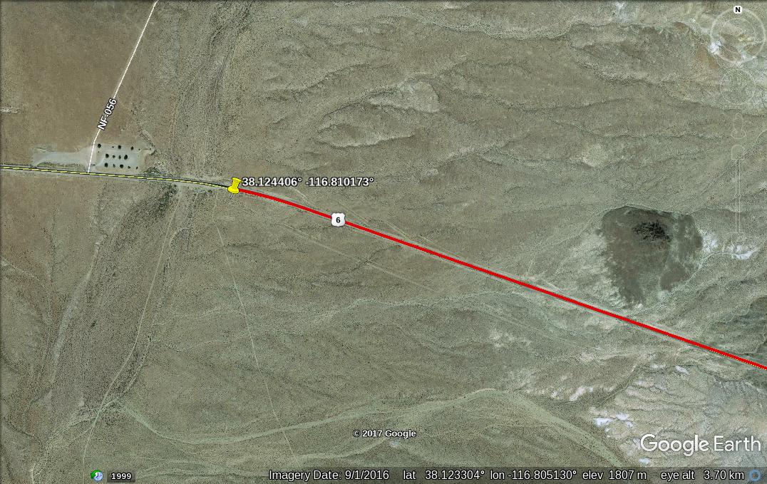
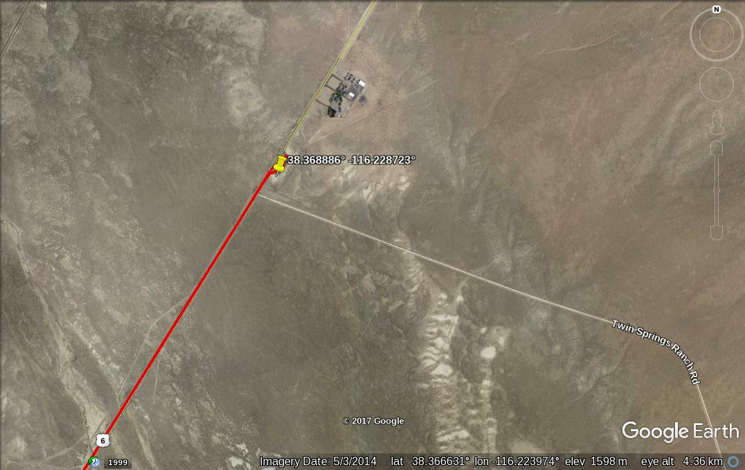
The eastern limit probably goes further. I only went as far at the Twin Springs rest stop. (No facilities there hint hint.)
It is a bit ironic, but the reception isn't the best right at Warm Springs. This is due to shading of the cell site by the mountain itself. Bear this in mind if you are looking for a place to rendezvous.
The southern limit might be further than indicated. This is because the phone was in network search mode and may have been looking for some other network. The distance to the intersection measures 9.8 miles.
The largest distance shown here is 20 miles of coverage. I suspect any location where you have a view of the Warm Springs cell site will have reception. This is useful if you are hiking around the range. I wouldn't bet on reception north of the cell site. That is the cell site may not be omnidirectional. My recollection of the cell site is they used panel antennas which implies a directional pattern.
Warm Springs overall
Warm Springs southern limit
Warm Springs western limit
Warm Springs eastern limit
The Warm Springs cell site is supposedly both Verizon compatible (CDMA?) and GSM (in this case UMTS). I have no way to tell if it actually works with Verizon phones. USA Commnet is a roaming partner of Tmobile. The bandwidth is virtally zero, basically good enough for email.
The western limit falls just short of the roadside rest. If you are familiar with the terrain, this makes sense. This is the rest stop that has a distant view of the Tonopah Test Range. Good enogh for scanning. I doubt you would see anything happening at the base.
The eastern limit probably goes further. I only went as far at the Twin Springs rest stop. (No facilities there hint hint.)
It is a bit ironic, but the reception isn't the best right at Warm Springs. This is due to shading of the cell site by the mountain itself. Bear this in mind if you are looking for a place to rendezvous.
The southern limit might be further than indicated. This is because the phone was in network search mode and may have been looking for some other network. The distance to the intersection measures 9.8 miles.
The largest distance shown here is 20 miles of coverage. I suspect any location where you have a view of the Warm Springs cell site will have reception. This is useful if you are hiking around the range. I wouldn't bet on reception north of the cell site. That is the cell site may not be omnidirectional. My recollection of the cell site is they used panel antennas which implies a directional pattern.
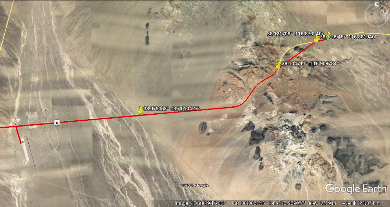
Here is the rest of the route to Tonopah. Pretty much you are good to the intersection with the road to the TTR, and from there all the way to Tonopah. For this stretch, you are using the tower located at 38.094433° -117.186539° on the USA Commnet network. I had a small section of Verizon GSM. Yes Verizon GSM is a thing. They bought some company and had to maintain the network. Unfortunately a google search for Verizon GSM ends up finding hits like "is Verizon GSM or CDMA). It is MCC 310 MNC 13 should anyone want to research it.
new topics
-
whistleblower Captain Bill Uhouse on the Kingman UFO recovery
Aliens and UFOs: 4 hours ago -
1980s Arcade
General Chit Chat: 6 hours ago -
Deadpool and Wolverine
Movies: 7 hours ago -
Teenager makes chess history becoming the youngest challenger for the world championship crown
Other Current Events: 8 hours ago -
CIA botched its handling of sexual assault allegations, House intel report says
Breaking Alternative News: 9 hours ago -
Lawsuit Seeks to ‘Ban the Jab’ in Florida
Diseases and Pandemics: 11 hours ago
top topics
-
Lawsuit Seeks to ‘Ban the Jab’ in Florida
Diseases and Pandemics: 11 hours ago, 20 flags -
Starburst galaxy M82 - Webb Vs Hubble
Space Exploration: 13 hours ago, 13 flags -
The Superstition of Full Moons Filling Hospitals Turns Out To Be True!
Medical Issues & Conspiracies: 15 hours ago, 8 flags -
CIA botched its handling of sexual assault allegations, House intel report says
Breaking Alternative News: 9 hours ago, 8 flags -
15 Unhealthiest Sodas On The Market
Health & Wellness: 13 hours ago, 6 flags -
whistleblower Captain Bill Uhouse on the Kingman UFO recovery
Aliens and UFOs: 4 hours ago, 6 flags -
Teenager makes chess history becoming the youngest challenger for the world championship crown
Other Current Events: 8 hours ago, 3 flags -
Deadpool and Wolverine
Movies: 7 hours ago, 3 flags -
1980s Arcade
General Chit Chat: 6 hours ago, 3 flags
active topics
-
Europe declares war on Russia?
World War Three • 60 • : Kurokage -
Russia Ukraine Update Thread - part 3
World War Three • 5713 • : F2d5thCavv2 -
IDF Intel Chief Resigns Over Hamas attack
Middle East Issues • 32 • : Terpene -
15 Unhealthiest Sodas On The Market
Health & Wellness • 32 • : VariedcodeSole -
Fast Moving Disc Shaped UFO Captured on Camera During Flight from Florida to New York City
Aliens and UFOs • 18 • : inflaymes69 -
Definitive 9.11 Pentagon EVIDENCE.
9/11 Conspiracies • 419 • : SchrodingersRat -
They Killed Dr. Who for Good
Rant • 61 • : Cymru -
How ageing is" immune deficiency"
Medical Issues & Conspiracies • 26 • : RookQueen2 -
The Democrats Take Control the House - Look what happened while you were sleeping
US Political Madness • 105 • : SchrodingersRat -
Starburst galaxy M82 - Webb Vs Hubble
Space Exploration • 4 • : SchrodingersRat
3