It looks like you're using an Ad Blocker.
Please white-list or disable AboveTopSecret.com in your ad-blocking tool.
Thank you.
Some features of ATS will be disabled while you continue to use an ad-blocker.

Hurricane Irma strengthening in the Atlantic
page: 6share:
a reply to: worldstarcountry
Not sure about Nyiah but Honeymoon Island is the spot. Love it down there and with my parks pass am there quite often. Nice pic by the way...
Not sure about Nyiah but Honeymoon Island is the spot. Love it down there and with my parks pass am there quite often. Nice pic by the way...
originally posted by: Thecakeisalie
a reply to: violet
if it doesn't fizzle out methinks it may make landfall between Cape Canaveral and Charlotte, if I had real time water temperature and barometric pressure readings I could be more precise.
I told some members long before Harvey hit to prepare because it would start to party, and it did. If the currents are warm and the pressure is low then be on alert, and if the storm slows as it hits the gulf stream, It might get nasty. II'd pay close attention on the eye-the smaller the eye the stronger the storm.
It's far too early to call but if you see the eye shrink in the weather reports, it's about to boogy, either way those holidaying in the Caribbean might want to return home as the weather will turn south.
Thanks for the info.
I've been watching the eye, it was there, then goes away( eye wall replacement cycles) . Right now it's very tight. Not sure how live the feed I'm using is though. I've been watching it since it started out, off the coast of Africa while Harvey was the main focus and wondered could this become a hurricane. I forget the term for it, is it Cape Verde? Something like that were typically they're very intense
originally posted by: AugustusMasonicus
originally posted by: violet
The Caribbean is looking to be a likely path. It's currently tracking west, southwest.
Best to keep an eye on it!
Well, United just issued a travel waiver for most of the Caribbean so my Cuba trip is cancelled.
Thanks Obama!!!
In that video on page 5 ( no hype one) I think it said it would skirt Cuba, a direct hit was uncertain. I'm on pause watching it. Very long video, but good
So next you're off to see the wildfires? Very hot and dry here out west.getting sick of it now lol
originally posted by: violet
In that video on page 5 ( no hype one) I think it said it would skirt Cuba, a direct hit was uncertain. I'm on pause watching it. Very long video, but good.
I cant take a chance with my work schedule, United only has one flight a day and they're mostly empty so they will be more apt to cancel than other flights.
So next you're off to see the wildfires? Very hot and dry here out west.getting sick of it now lol
Yes indeed. Wine harvest time in Sonoma.
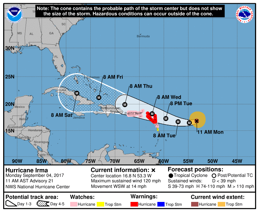
Latest Cone Map from the National Hurricane Center
edit on 4-9-2017 by violet because: (no reason given)
11am AST
Hurricane Warning is in effect for...
* Antigua, Barbuda, Anguilla, Montserrat, St. Kitts, and Nevis
* Saba, St. Eustatius, and Sint Maarten
* Saint Martin and Saint Barthelemy
A Hurricane Watch is in effect for...
* Guadeloupe
* British Virgin Islands
* U.S. Virgin Islands
* Puerto Rico, Vieques, and Culebra
A Tropical Storm Watch is in effect for...
* Dominica
DISCUSSION AND 48-HOUR OUTLOOK
------------------------------
At 1100 AM AST (1500 UTC), the eye of Hurricane Irma was located
near latitude 16.8 North, longitude 53.3 West. Irma is moving toward
the west-southwest near 14 mph (22 km/h). A turn toward the west
is expected later today, followed by a west-northwestward turn late
Tuesday. On the forecast track, the center of Irma will move near
or over portions of the northern Leeward Islands Tuesday night
and early Wednesday.
Maximum sustained winds are near 120 mph (195 km/h) with higher
gusts. Irma is a category 3 hurricane on the Saffir-Simpson
Hurricane Wind Scale. Additional strengthening is forecast through
Tuesday night.
Hurricane-force winds extend outward up to 35 miles (55 km) from the
center and tropical-storm-force winds extend outward up to 140 miles
(220 km).
The estimated minimum central pressure based on data from a NOAA
Hurricane Hunter aircraft is 944 mb (27.88 inches).
NHC
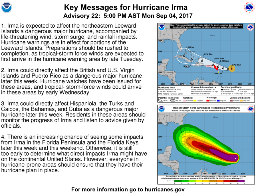
Regarding Florida
There is an increasing chance of seeing some impacts from Irma in
the Florida Peninsula and the Florida Keys later this week and this
weekend. In addition, rough surf and dangerous marine conditions
will begin to affect the southeastern U.S. coast by later this week.
Otherwise, it is still too early to determine what direct impacts
Irma might have on the continental United States.
a reply to: AugustusMasonicus
Re Cuba
Re Cuba
Irma could directly affect Hispaniola, the Turks and Caicos, the
Bahamas, and Cuba as a dangerous major hurricane later this week.
Residents in these areas should monitor the progress of Irma and
listen to advice given by officials.
I appreciate you keeping us updated. Im just referring to this thread now everyday to see whats going on with Irma. I think by Thursday we will know
how vulnerable Florida will be to the path of this storm.
a reply to: worldstarcountry yes Thursday will give us a better idea of its trajectory and strength.
I used to be forced to buy flood insurance and it was very expensive and generally not worth the paper it was written on. So many clauses. Now I live
on Lake Michigan and it's not required, go figure.
edit on 4-9-2017 by mikell because: (no reason given)
a reply to: worldstarcountry
Naaah, I get real seasons & don't sweat to death up in the summer here, I'm not going back down there I miss the sea breeze thunderstorms and hurricane season, though -- thunderstorms here aren't that intense, it's not as much fun to observe 'canes from 1500 miles away as it is from in the cross hairs (there is a certain appeal to that and most native/long-term residents know it whether they admit it or not )
Honeymoon was one of the places I never made it to. I'm real fond of Anna Maria Island, though. There's just something about the island that was always a "moth to flame" draw for me, we preferred taking the kids down there over closer beaches to the metro.
I think as far as analog storms to compare to go, Irma's going to be a coin toss between a Charley 2.0 track, or a surprise Katrina 2.0 track. Just a hunch going off today's models.
I am in Daytona Beach, and have started stocking water, food provisions, charcoal, lamp oil, and gasoline for the generator. Oh, and rum. Lots of rum.
It looks like Harvey carved a corridor though the atmosphere, and Irma is following that path of least resistance.
Latest updates 5pm AST
From NHC
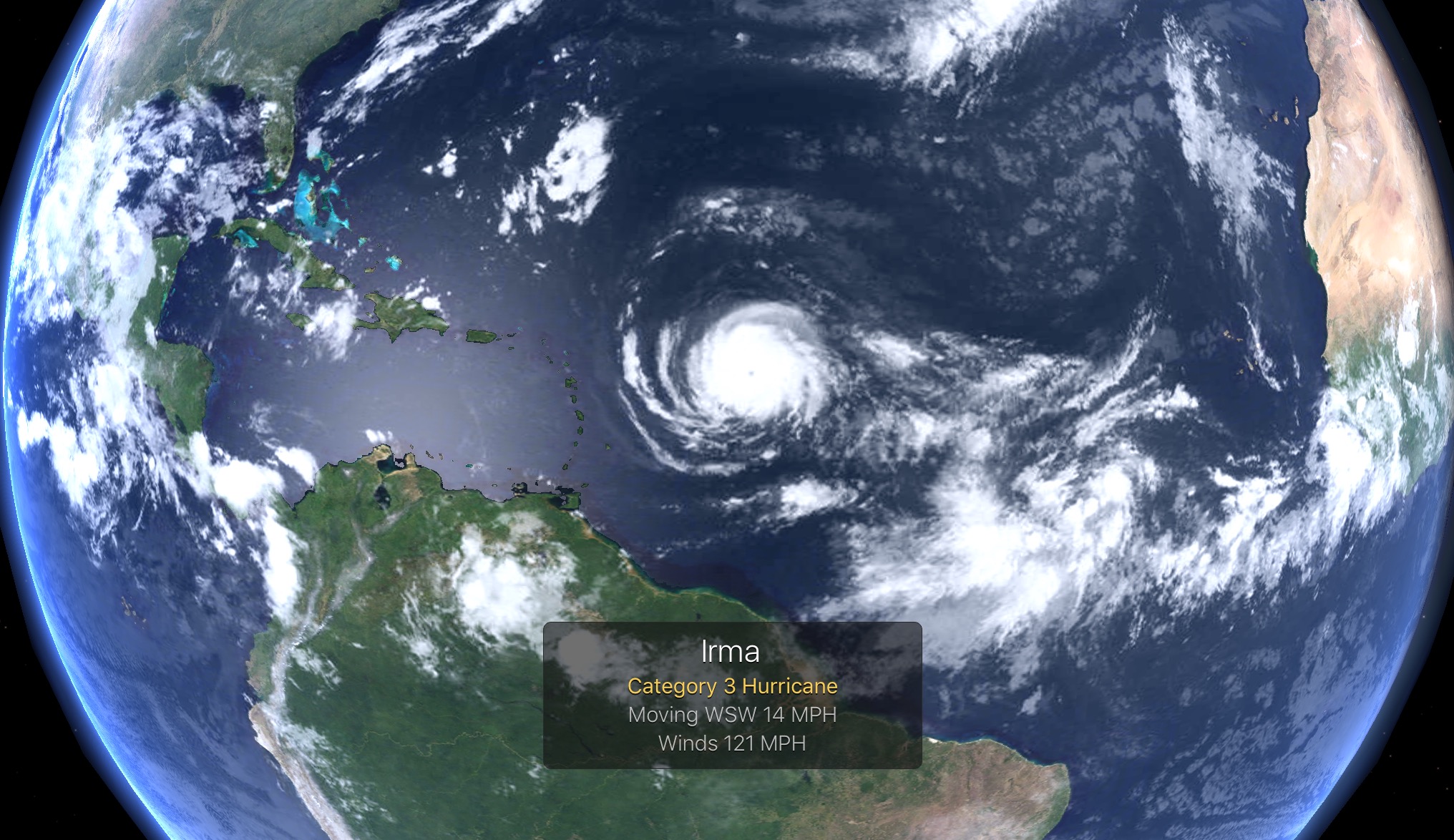
Cat 4 now
...IRMA STRENGTHENS AS IT HEADS TOWARD THE LEEWARD ISLANDS... ...PREPARATIONS WITHIN THE WARNING AREA SHOULD BE RUSHED TO COMPLETION...
From NHC
Cat 4 now
...IRMA STRENGTHENS AS IT HEADS TOWARD THE LEEWARD ISLANDS... ...PREPARATIONS WITHIN THE WARNING AREA SHOULD BE RUSHED TO COMPLETION...
edit on 4-9-2017 by violet because: (no reason given)
edit on 4-9-2017 by violet because: (no reason
given)
a reply to: Nyiah
Anna Maria is wonderful too! The closest place to ride horses on the beach! Theres another one further north, but its farther and the water is not as nice. I have been to every beach and almost every island from Ancolote Key and Howard Park Beach in Tarpon Springs down to Ledo Beach down by Sarasota and Bradenton. Tarpon springs is the best beach to go snorkeling. If you want to do kite surfing/wind surfing, your best bet Is Ft. DeSoto park, and Honeymoon is a close second. Im so done with Clearwater. It was my parents go to beach when we were younger. But now everytime I go it is waaaay too overcrowded. St Pete is still nice. Treasure Island, Indian Rocks, Madeira, Indian Shores, Holmes Beach, Bradenton Beach are also wonderful regular beaches that aare not neaarly as crowded as Clearwater. Well St. Pete sometimes.
My next destination I want to visit is Sanabel Island down in the Cape Coral/Ft. Myers area. They have some of the best shelling in the country! As well I want to visit their shell museum, which is the only one in the world dedicated entirely to the study and research of seashells.
Violet, if that storm comes this way, Im going to get an awesome sky picture from Honeymoon and post them up. But I just have this gut feeling it is going to skirt right by Florida without too much trouble.
new topics
-
George Knapp AMA on DI
Area 51 and other Facilities: 3 hours ago -
Not Aliens but a Nazi Occult Inspired and then Science Rendered Design.
Aliens and UFOs: 4 hours ago -
Louisiana Lawmakers Seek to Limit Public Access to Government Records
Political Issues: 6 hours ago -
The Tories may be wiped out after the Election - Serves them Right
Regional Politics: 7 hours ago -
So I saw about 30 UFOs in formation last night.
Aliens and UFOs: 9 hours ago -
Do we live in a simulation similar to The Matrix 1999?
ATS Skunk Works: 10 hours ago -
BREAKING: O’Keefe Media Uncovers who is really running the White House
US Political Madness: 10 hours ago -
Biden--My Uncle Was Eaten By Cannibals
US Political Madness: 11 hours ago -
"We're All Hamas" Heard at Columbia University Protests
Social Issues and Civil Unrest: 11 hours ago
top topics
-
BREAKING: O’Keefe Media Uncovers who is really running the White House
US Political Madness: 10 hours ago, 23 flags -
George Knapp AMA on DI
Area 51 and other Facilities: 3 hours ago, 18 flags -
Biden--My Uncle Was Eaten By Cannibals
US Political Madness: 11 hours ago, 18 flags -
African "Newcomers" Tell NYC They Don't Like the Free Food or Shelter They've Been Given
Social Issues and Civil Unrest: 17 hours ago, 12 flags -
"We're All Hamas" Heard at Columbia University Protests
Social Issues and Civil Unrest: 11 hours ago, 7 flags -
Louisiana Lawmakers Seek to Limit Public Access to Government Records
Political Issues: 6 hours ago, 7 flags -
Russian intelligence officer: explosions at defense factories in the USA and Wales may be sabotage
Weaponry: 16 hours ago, 6 flags -
So I saw about 30 UFOs in formation last night.
Aliens and UFOs: 9 hours ago, 5 flags -
The Tories may be wiped out after the Election - Serves them Right
Regional Politics: 7 hours ago, 3 flags -
Not Aliens but a Nazi Occult Inspired and then Science Rendered Design.
Aliens and UFOs: 4 hours ago, 3 flags
active topics
-
Candidate TRUMP Now Has Crazy Judge JUAN MERCHAN After Him - The Stormy Daniels Hush-Money Case.
Political Conspiracies • 376 • : RazorV66 -
-@TH3WH17ERABB17- -Q- ---TIME TO SHOW THE WORLD--- -Part- --44--
Dissecting Disinformation • 531 • : cherokeetroy -
Biden--My Uncle Was Eaten By Cannibals
US Political Madness • 41 • : Halfswede -
So I saw about 30 UFOs in formation last night.
Aliens and UFOs • 20 • : Halfswede -
MULTIPLE SKYMASTER MESSAGES GOING OUT
World War Three • 33 • : Halfswede -
George Knapp AMA on DI
Area 51 and other Facilities • 12 • : theshadowknows -
Not Aliens but a Nazi Occult Inspired and then Science Rendered Design.
Aliens and UFOs • 7 • : JonnyC555 -
Mood Music Part VI
Music • 3057 • : BatCaveJoe -
The Tories may be wiped out after the Election - Serves them Right
Regional Politics • 19 • : alwaysbeenhere2 -
"We're All Hamas" Heard at Columbia University Protests
Social Issues and Civil Unrest • 125 • : KrustyKrab