It looks like you're using an Ad Blocker.
Please white-list or disable AboveTopSecret.com in your ad-blocking tool.
Thank you.
Some features of ATS will be disabled while you continue to use an ad-blocker.

Hurricane Irma strengthening in the Atlantic
page: 40share:
The latest update reflects the 3 p.m. National Hurricane Center ....
The latest computer model forecasts suggest the vicious storm is likely to ride up Florida’s west coast, with a combination of destructive winds and a devastating storm surge from the Florida Keys through Naples and Fort Myers and up the coast to Tampa. It’s not clear exactly where the storm will make landfall, but winds well in excess of 100 mph could batter numerous population centers along Florida’s west coast. And coastal waters could rise 10 to 15 feet above normally dry land, completely inundating homes, businesses, and roads.
ext
Washington Post
a reply to: Liquesence
The Florida director said he's most concerned about where the hundred mile per hour cone goes.. He said Floridians take 75 mile-per-hour winds in stride.
The Florida director said he's most concerned about where the hundred mile per hour cone goes.. He said Floridians take 75 mile-per-hour winds in stride.
Key West feed is up and running. Wishing good luck to them. Take care.
a reply to: Liquesence
Sometimes a more compact storm can pack a stronger punch, the circulation is tighter and this concentrates the power. It becomes a (tiny) bit more diffuse with a larger windfield, but these winds are still going to be quite destructive over wide areas.
Miami may have missed the eyewall, but it's going to get the front right quadrant which spins off all those ef0 and ef1 bouncers that cause so much hit and miss damage.
The warmth of the water over which it is passing and the moisture in the air feeding it right now are going to allow for strengthening again before it makes landfall.
This is going to be bad, folks.
a reply to: roadgravel
Yes prayers and thoughts to all
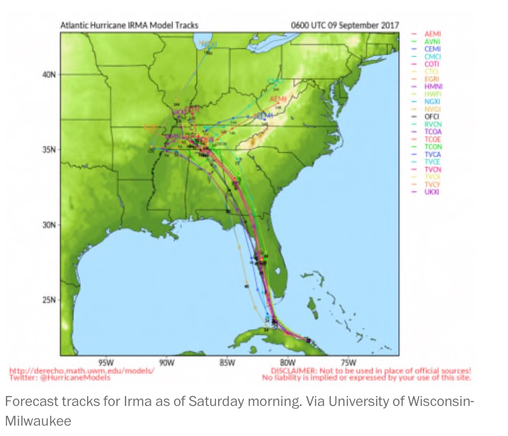
Looking like the keys might be the cat 4 landfall. It's just starting to make a more northern turn. The track looks like it will ride up the west coast of FLA
Yes prayers and thoughts to all
Looking like the keys might be the cat 4 landfall. It's just starting to make a more northern turn. The track looks like it will ride up the west coast of FLA
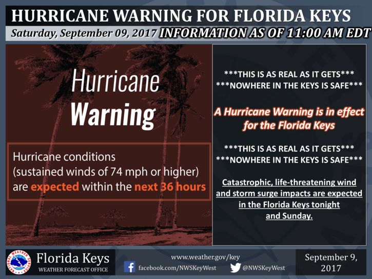
Key West forecast
Tonight Sat 09/09 Low 81 F
100% Precip. / 8.78 in
Heavy Rain/Wind. Low 81F. Winds NNE at 80 to 100 mph.
Tomorrow Sun 09/10 High 84 F
100% Precip. / 4.62 in
Heavy Rain/Wind. High 84F. Winds W at 100 to 115 mph
-
104.9 in the keys is playing some good tunes on the feed...
Tonight Sat 09/09 Low 81 F
100% Precip. / 8.78 in
Heavy Rain/Wind. Low 81F. Winds NNE at 80 to 100 mph.
Tomorrow Sun 09/10 High 84 F
100% Precip. / 4.62 in
Heavy Rain/Wind. High 84F. Winds W at 100 to 115 mph
-
104.9 in the keys is playing some good tunes on the feed...
edit on 9/9/2017 by roadgravel because: (no reason given)
a reply to: jadedANDcynical
I feel bad I'm just a voyeur watching it unfold in the comfort of my living-room. Admittedly I'm curious about the aftermath. So much hype about this storm. Will see how much of the predictions come true. Hopefully it doesn't of course.
It's gonna be really bad though
Those cranes spinning around are scary. I'd be afraid one smashes into a building
I hope the storm move quickly to minimize the water/flooding. Harvey really messed up Houston with water.
a reply to: roadgravel
Gary Ek, the 104.9 DJ is one crazy guy. He was my neighbor last summer at Key West Bight Marina.
Unfortunately the Schooner Wharf webcam is down, that is where I work(ed).
Gary Ek, the 104.9 DJ is one crazy guy. He was my neighbor last summer at Key West Bight Marina.
Unfortunately the Schooner Wharf webcam is down, that is where I work(ed).
originally posted by: jrod
a reply to: roadgravel
Gary Ek, the 104.9 DJ is one crazy guy. He was my neighbor last summer at Key West Bight Marina.
Unfortunately the Schooner Wharf webcam is down, that is where I work(ed).
Best to him. Guess if the tunes are up, he's OK, assuming he is staying. Thanks for that live feed link.
Storm Chaser Jeff Piotrowski: In Marco island, Naples:Live feed
Checked the Weather Channel live feed they are saying Irma is expected to gain strength(just under cat 5) as mentioned before.
Between Ft. Meyers and Tampa: gas shortages, shelters filling, roads gridlocked.
Checked the Weather Channel live feed they are saying Irma is expected to gain strength(just under cat 5) as mentioned before.
Between Ft. Meyers and Tampa: gas shortages, shelters filling, roads gridlocked.
Twofriends rooftop cam is streaming.
www.twofriends.com...
NOAA has a weather station that will be worth monitoring.
www.ndbc.noaa.gov...
www.twofriends.com...
NOAA has a weather station that will be worth monitoring.
www.ndbc.noaa.gov...
a reply to: roadgravel
No problem. I know of about 20 people who are staying, Gary and his wife included.
The storm now appears to pulling away from Cuba. Very hot water around the keys, and a low shear environment is a dangerous set up. Both the Euro and GFS computer models predict rapid intensification.
The 5pm NHC advisory will be out soon.
a reply to: violet
I know what you mean, but it's human nature. Same thing makes people slow down to look at a car wreck on the side of the road.
You might not have hurricanes, but maybe you have earthquakes to contend with. We live on a potentially dangerous planet where natural process can decimate what we have claimed to have won as ours.
Wee puny humans compared to what goes on around us daily.
a reply to: roadgravel
Harvey got stuck between two high pressure systems which effectively cut it off from all steering mechanisms.
Irma is just chugging along and about the only thing which could have seriously degraded it's destructive power was if the eye had passed over Cuba's highlands. This unfortunately did not happen, and so, much of Irma's power remains. Thankfully the Florida straights aren't a huge body of water and Irma seems intent in it's forward momentum.
There will be storm surge and damaging winds with which to contend.
Around 8 central, Tim Vasquez will be doing his nightly live stream and should have some really good up to date analysis of Irma's development and near term future activity.
new topics
-
That which the "news" never talks about; Truth about election fraud
Mainstream News: 32 minutes ago -
Biden doesnt want the votes of "Death to America" chanters
US Political Madness: 39 minutes ago -
Horizon Post office scandal
Regional Politics: 1 hours ago -
Joe Biden and Donald Trump are both traitors
US Political Madness: 3 hours ago -
I'm new here. Avid conspiracy fan.
Introductions: 3 hours ago -
Denmark's Notre-Dame moment - 17th Century Borsen goes up in Flames
Mainstream News: 5 hours ago
top topics
-
Suspected Iranian agent working for Pentagon while U.S. coordinated defense of Israel
US Political Madness: 12 hours ago, 16 flags -
The Baloney aka BS Detection Kit
Social Issues and Civil Unrest: 12 hours ago, 7 flags -
That which the "news" never talks about; Truth about election fraud
Mainstream News: 32 minutes ago, 5 flags -
Denmark's Notre-Dame moment - 17th Century Borsen goes up in Flames
Mainstream News: 5 hours ago, 4 flags -
How does my computer know
Education and Media: 15 hours ago, 3 flags -
I'm new here. Avid conspiracy fan.
Introductions: 3 hours ago, 3 flags -
Joe Biden and Donald Trump are both traitors
US Political Madness: 3 hours ago, 2 flags -
Horizon Post office scandal
Regional Politics: 1 hours ago, 1 flags -
Biden doesnt want the votes of "Death to America" chanters
US Political Madness: 39 minutes ago, 0 flags
active topics
-
It has begun... Iran begins attack on Israel, launches tons of drones towards the country
World War Three • 750 • : WeMustCare -
Candidate TRUMP Now Has Crazy Judge JUAN MERCHAN After Him - The Stormy Daniels Hush-Money Case.
Political Conspiracies • 241 • : WeMustCare -
SHORT STORY WRITERS CONTEST -- April 2024 -- TIME -- TIME2024
Short Stories • 18 • : argentus -
Abortions in first 12 weeks should be legalised in Germany, commission says
Medical Issues & Conspiracies • 18 • : Consvoli -
That which the "news" never talks about; Truth about election fraud
Mainstream News • 1 • : watchitburn -
Joe Biden and Donald Trump are both traitors
US Political Madness • 34 • : andy06shake -
Biden doesnt want the votes of "Death to America" chanters
US Political Madness • 1 • : Disgusted123 -
How does my computer know
Education and Media • 18 • : MrGashler -
Truth Social goes public, be careful not to lose your money
Mainstream News • 114 • : matafuchs -
NYAG Letitia James Prepares to Begin Seizing TRUMP Assets Even Though There Was No Crime.
Above Politics • 285 • : matafuchs