It looks like you're using an Ad Blocker.
Please white-list or disable AboveTopSecret.com in your ad-blocking tool.
Thank you.
Some features of ATS will be disabled while you continue to use an ad-blocker.

Hurricane Irma strengthening in the Atlantic
page: 21share:
I got 2 of these 275 gal tanks used, at our local feed store for $150.00 each. They are safe for potable water. They were used once for milk I think,
some are used for pickle brine. Check your local feed stores, these are especially handy if you're in a situation with warning like you guys are. Just
fill them up when you have a storm coming. They aren't very big either so you can stick them in a garage easy.

I'm in Cali so earthquakes are our issue and fires. So I have to keep them stocked up most of the time. I also add a bit of bleach to keep them clean and algae down. I built a cover around them with that Styrofoam insulation board so they don't freeze so bad or get too much sun.
I don't keep them full all the time but mostly. I also bought a hand pump to get the water out for $25 at harbor freight for them. 550 gallons for 9 people, 8 dogs, 2 birds, 4 cats and 2 lizards for under $400 bucks.
originally posted by: AndyFromMichigan
originally posted by: jrod
a reply to: violet
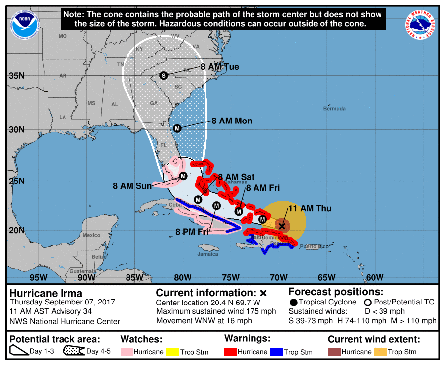
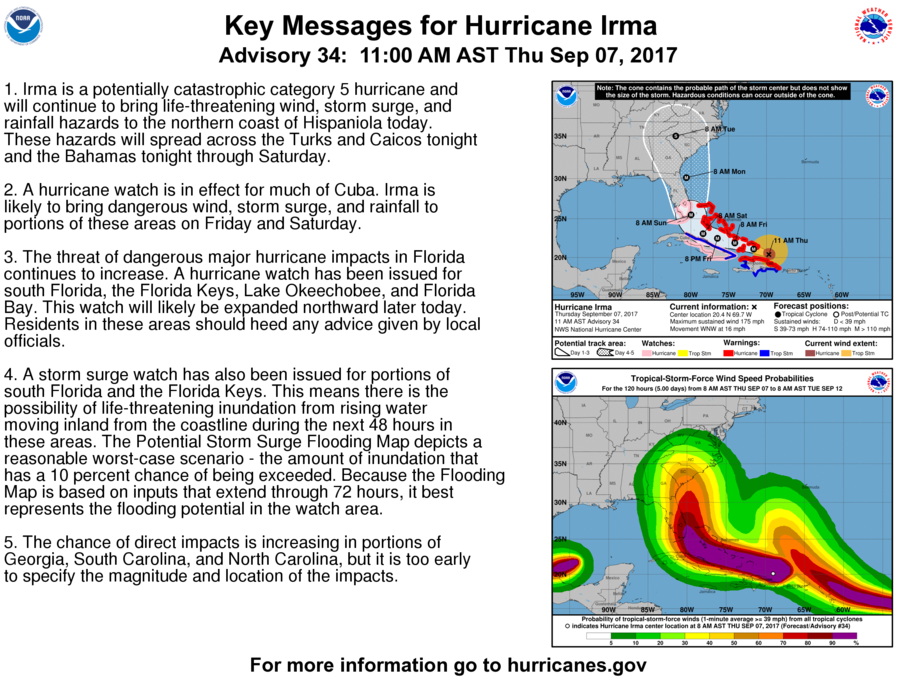
11am just came out:
11:00 AM AST Thu Sep 7
Location: 20.4°N 69.7°W
Moving: WNW at 16 mph
Min pressure: 921 mb
Max sustained: 175 mph
Hurricane watch now issued for S. Florida, the Keys, and Lake Okeechobee
Looks like they're predicting a direct hit on Miami.
Miami is definitely in danger, especially near the water with storm surge but the exact landfall is still uncertain. As time closes in we'll get a better idea
Hurricane Watch has now been issued for South Florida including both the west and east coast.

originally posted by: ProphetZoroaster
Hurricane Watch has now been issued for South Florida including both the west and east coast.
Thanks for posting that
Latest update from National Hurricane Center
...EXTREMELY DANGEROUS HURRICANE IRMA HEADING FOR THE TURKS AND CAICOS ISLANDS... ...HURRICANE AND STORM SURGE WATCH ARE IN EFFECT FOR PORTIONS OF SOUTH FLORIDA AND THE FLORIDA KEYS...
11:00 AM AST Thu Sep 7
Status Category 5
Location: 20.4°N 69.7°W
Moving: WNW at 16 mph
Min pressure: 921 mb
Max sustained: 175 mph
000
AXNT20 KNHC 071153
TWDAT
Tropical Weather Discussion
NWS National Hurricane Center Miami FL
805 AM EDT Thu Sep 7 2017
Tropical Weather Discussion for North America, Central America
Gulf of Mexico, Caribbean Sea, northern sections of South
America, and Atlantic Ocean to the African coast from the
Equator to 32N. The following information is based on satellite
imagery, weather observations, radar and meteorological analysis.
Based on 0600 UTC surface analysis and satellite imagery through
1015 UTC.
...
The center of Hurricane Irma, at 07/1200 UTC is near 20.1N
69.0W, or about 90 nm to the N of Punta Cana in the Dominican
Republic, or about 150 nm to the SE of Grand Turk Island. Irma
is moving WNW, 290 degrees, 15 knots. The estimated minimum
central pressure is 921 mb. The maximum sustained wind speeds
are 155 kt with gusts to 190 kt. Irma is the strongest hurricane
to be in the Atlantic basin outside of the Caribbean Sea and the
Gulf of Mexico. Irma has a well defined eye about 20 NM in
diameter. Convective precipitation: numerous strong within 120
nm of the center in the E semicircle, and within 75 nm to 90 nm
of the center in the W semicircle. Widely scattered moderate to
isolated strong elsewhere from 17N to 25N between 62W and 73W.
3. The threat of dangerous major hurricane impacts in Florida
continues to increase. A hurricane watch has been issued for south
Florida, the Florida Keys, Lake Okeechobee, and Florida Bay. This
watch will likely be expanded northward later today. Residents in
these areas should heed any advice given by local officials.
4. A storm surge watch has also been issued for portions of south
Florida and the Florida Keys. This means there is the possibility of
life-threatening inundation from rising water moving inland from the
coastline during the next 48 hours in these areas. The Potential
Storm Surge Flooding Map depicts a reasonable worst-case scenario -
the amount of inundation that has a 10 percent chance of being
exceeded. Because the Flooding Map is based on inputs that extend
through 72 hours, it best represents the flooding potential in the
watch area.
5. The chance of direct impacts is increasing in portions of
Georgia, South Carolina, and North Carolina, but it is too early to
specify the magnitude and location of the impacts.
...EXTREMELY DANGEROUS HURRICANE IRMA HEADING FOR THE TURKS AND CAICOS ISLANDS... ...HURRICANE AND STORM SURGE WATCH ARE IN EFFECT FOR PORTIONS OF SOUTH FLORIDA AND THE FLORIDA KEYS...
11:00 AM AST Thu Sep 7
Status Category 5
Location: 20.4°N 69.7°W
Moving: WNW at 16 mph
Min pressure: 921 mb
Max sustained: 175 mph
000
AXNT20 KNHC 071153
TWDAT
Tropical Weather Discussion
NWS National Hurricane Center Miami FL
805 AM EDT Thu Sep 7 2017
Tropical Weather Discussion for North America, Central America
Gulf of Mexico, Caribbean Sea, northern sections of South
America, and Atlantic Ocean to the African coast from the
Equator to 32N. The following information is based on satellite
imagery, weather observations, radar and meteorological analysis.
Based on 0600 UTC surface analysis and satellite imagery through
1015 UTC.
...
The center of Hurricane Irma, at 07/1200 UTC is near 20.1N
69.0W, or about 90 nm to the N of Punta Cana in the Dominican
Republic, or about 150 nm to the SE of Grand Turk Island. Irma
is moving WNW, 290 degrees, 15 knots. The estimated minimum
central pressure is 921 mb. The maximum sustained wind speeds
are 155 kt with gusts to 190 kt. Irma is the strongest hurricane
to be in the Atlantic basin outside of the Caribbean Sea and the
Gulf of Mexico. Irma has a well defined eye about 20 NM in
diameter. Convective precipitation: numerous strong within 120
nm of the center in the E semicircle, and within 75 nm to 90 nm
of the center in the W semicircle. Widely scattered moderate to
isolated strong elsewhere from 17N to 25N between 62W and 73W.
edit on 7-9-2017 by violet because: (no reason given)
edit on
7-9-2017 by violet because: (no reason given)
3. The threat of dangerous major hurricane impacts in Florida
continues to increase. A hurricane watch has been issued for south
Florida, the Florida Keys, Lake Okeechobee, and Florida Bay. This
watch will likely be expanded northward later today. Residents in
these areas should heed any advice given by local officials.
4. A storm surge watch has also been issued for portions of south
Florida and the Florida Keys. This means there is the possibility of
life-threatening inundation from rising water moving inland from the
coastline during the next 48 hours in these areas. The Potential
Storm Surge Flooding Map depicts a reasonable worst-case scenario -
the amount of inundation that has a 10 percent chance of being
exceeded. Because the Flooding Map is based on inputs that extend
through 72 hours, it best represents the flooding potential in the
watch area.
5. The chance of direct impacts is increasing in portions of
Georgia, South Carolina, and North Carolina, but it is too early to
specify the magnitude and location of the impacts.
edit on 7-9-2017 by violet because: (no reason given)
edit on 7-9-2017 by
violet because: (no reason given)
From
Acuweather
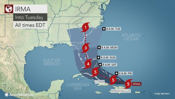
"Unfortunately, there is no way the United States is going to avoid another catastrophic weather event," Dr. Joel N. Myers, founder, president and chairman of AccuWeather said.
"There will be massive damage in Florida. [It will be] the worst single hurricane to hit Florida since Hurricane Andrew in 1992," Myers said.
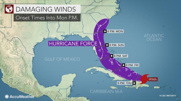
The current track of Florida will bring the most severe impacts to the eastern side of the state, including Miami, West Palm Beach, Melbourne, Daytona Beach and Jacksonville. Tropical-storm-force conditions could be felt as far west as Tampa and Key West.
"Irma remains a very powerful and destructive hurricane," AccuWeather Hurricane Expert Dan Kottlowski said.
"Impacts within the projected path of Irma include life-threatening wind, storm surge and flooding rainfall hazards," Kottlowski added.
Conditions will rapidly deteriorate across South Florida and could turn life-threatening late Saturday into Sunday. This is when rain and hurricane-force winds will quickly intensify.
Torrential rainfall, high winds and inundating seas will then increase from south to north across the Florida Peninsula on Sunday into Monday.
edit on 7-9-2017 by violet because: (no reason given)
edit on 7-9-2017 by violet because: (no reason
given)
edit on 7-9-2017 by violet because: (no reason given)
edit on Thu Sep 7 2017 by DontTreadOnMe because: trimmed
overly long quote & added EX TAGS IMPORTANT: Using Content From Other Websites on
ATS
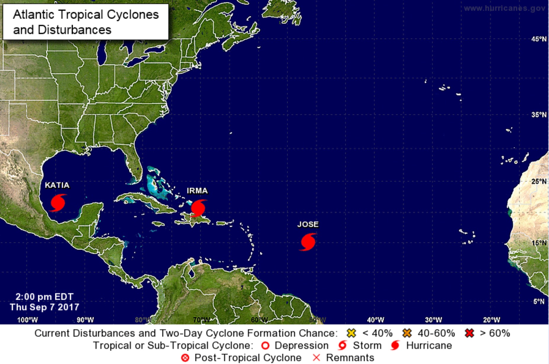
Also ...JOSE NOW A CATEGORY 2 HURRICANE
edit on 7-9-2017 by violet because: (no reason given)
a reply to: violet
there are now 3 hurricanes in the Atlantic www.dailymail.co.uk...
last time this happened was 7 years ago
there are now 3 hurricanes in the Atlantic www.dailymail.co.uk...
last time this happened was 7 years ago
edit on 7-9-2017 by research100 because: dang spelling
originally posted by: research100
a reply to: violet
there are now 3 hurricanes in the Atlantic www.dailymail.co.uk...
last time this happened was 7 years ago
Katia is in the gulf aimed at Mexico for now, hopefully it doesn't trek north or interact with Irma , if Irma's path changes
edit on 7-9-2017 by violet because: (no reason given)
It is looking less and less likely Florida will avoid the brunt of this now but you never know. Always hope for the best even when expecting the
worst.
I hope that those who can get out do, and those that can't can find safety.
With luck Irma decides to turn north for a quick jaunt up to Maryland losing heat as she goes.
I hope that those who can get out do, and those that can't can find safety.
With luck Irma decides to turn north for a quick jaunt up to Maryland losing heat as she goes.

a reply to: Dumbass
I have seen some ugly pictures of the devastation wrecked on the islands, including St. Martin.
I still have not heard from my family over there, and no one else in the family has heard anything either. We are all texting and emailing because we know that we stand a better chance of making a connection that way, since the power is probably out across the island.
I hate Facebook but this is a time it would come in handy. But no connection there either.
new topics
-
Any one suspicious of fever promotions events, major investor Goldman Sachs card only.
The Gray Area: 56 minutes ago -
God's Righteousness is Greater than Our Wrath
Religion, Faith, And Theology: 5 hours ago -
Electrical tricks for saving money
Education and Media: 8 hours ago -
VP's Secret Service agent brawls with other agents at Andrews
Mainstream News: 9 hours ago -
Sunak spinning the sickness figures
Other Current Events: 10 hours ago -
Nearly 70% Of Americans Want Talks To End War In Ukraine
Political Issues: 10 hours ago
top topics
-
VP's Secret Service agent brawls with other agents at Andrews
Mainstream News: 9 hours ago, 9 flags -
Cats Used as Live Bait to Train Ferocious Pitbulls in Illegal NYC Dogfighting
Social Issues and Civil Unrest: 13 hours ago, 8 flags -
Electrical tricks for saving money
Education and Media: 8 hours ago, 4 flags -
HORRIBLE !! Russian Soldier Drinking Own Urine To Survive In Battle
World War Three: 17 hours ago, 3 flags -
Sunak spinning the sickness figures
Other Current Events: 10 hours ago, 3 flags -
Nearly 70% Of Americans Want Talks To End War In Ukraine
Political Issues: 10 hours ago, 3 flags -
Late Night with the Devil - a really good unusual modern horror film.
Movies: 12 hours ago, 2 flags -
The Good News According to Jesus - Episode 1
Religion, Faith, And Theology: 15 hours ago, 1 flags -
Any one suspicious of fever promotions events, major investor Goldman Sachs card only.
The Gray Area: 56 minutes ago, 1 flags -
God's Righteousness is Greater than Our Wrath
Religion, Faith, And Theology: 5 hours ago, 0 flags
active topics
-
SETI chief says US has no evidence for alien technology. 'And we never have'
Aliens and UFOs • 57 • : andy06shake -
Terrifying Encounters With The Black Eyed Kids
Paranormal Studies • 76 • : Consvoli -
God's Righteousness is Greater than Our Wrath
Religion, Faith, And Theology • 6 • : randomuser2034 -
Samuel Aun Woer
Religion, Faith, And Theology • 27 • : helebi20 -
Any one suspicious of fever promotions events, major investor Goldman Sachs card only.
The Gray Area • 2 • : Cavemannick -
Nearly 70% Of Americans Want Talks To End War In Ukraine
Political Issues • 18 • : gortex -
HORRIBLE !! Russian Soldier Drinking Own Urine To Survive In Battle
World War Three • 35 • : twistedpuppy -
VP's Secret Service agent brawls with other agents at Andrews
Mainstream News • 42 • : 38181 -
The Acronym Game .. Pt.3
General Chit Chat • 7746 • : bally001 -
Russia Ukraine Update Thread - part 3
World War Three • 5728 • : F2d5thCavv2