It looks like you're using an Ad Blocker.
Please white-list or disable AboveTopSecret.com in your ad-blocking tool.
Thank you.
Some features of ATS will be disabled while you continue to use an ad-blocker.

The weight of Hurricane Harvey and Earthquakes. Is there a correlation
page: 124
share:
I find it interesting that one gallon of water weighs 8.3453 pounds. One cubic foot of water contains 7.48052 gallons. The weight of one cubic foot of
water is 7.48052 gallons times 8.3453 pounds, which equals 62.42718356 pounds of water per cubic foot. One cubic foot contains 1728 cubic inches. The
weight of one cubic inch of water is 62.42718356 pounds divided by 1728 cubic inches, which equals 0.036126842 pounds of water per cubic inch. The
weight of one inch of rain on one acre of land is 6,272,640 cubic inches of water per acre times 0.036126842 pounds of water per cubic inch, which
equals 226,610.6763 pounds of water per acre. There are 2000 pounds in one ton. The weight of water per acre, 226,610.6763 pounds divided by 2000
pounds per ton, equals 113.3053382 tons of water in one inch of rain on one acre of land.
www.ag.ndsu.edu...
Houston Texas is about 655 square miles. www.visithoustontexas.com...
Converting 655 square miles to acres “ www.metric-conversions.org... “ you get 419200 acres. One inch of rain in Houston, would weigh about 47495360 TONS! Hurricane The Cedar Bayou gauge near Highlands, Texas, has reported a preliminary 51.88 inches through 3 p.m. CDT Tuesday. weather.com...
So Houston has 419,200 acres, times 113.30 tons of water per inch of rain (remember per acre) equals 47,495,360 tons, multiplied by 51.88 inches equals…..2,464,059,276.8 additional tons for this small area of Texas.
CNN reports,” the storm that blasted ashore as a Category 4 around 11 p.m. ET Friday between Port Arkansas and Port O'Connor.” www.cnn.com...
While Harvey dumping 100,000’s of thousands of tons in the Gulf, Knoxville TN has a 2.7,New Madrid had an EQ had a 2.7 on the Friday the 24th and a 2.9 just across the river. Both of these EQ’s were about 8.4 Km to 10 Km deep. Irving Texas has a 3.1 on the 25th, and a slew of others in the usual Oklahoma City area as well. earthquake.usgs.gov... %22%2C%22listFormat%22%3A%22default%22%2C%22mapposition%22%3A%5B%5B29.49698759653577%2C-103.0078125%5D%2C%5B44.18220395771566%2C-78.3544921875%5D%5D%2 C%22overlays%22%3A%5B%22plates%22%5D%2C%22restrictListToMap%22%3A%5B%22restrictListToMap%22%5D%2C%22search%22%3Anull%2C%22sort%22%3A%22newest%22%2C%22 timezone%22%3A%22utc%22%2C%22viewModes%22%3A%5B%22list%22%2C%22settings%22%2C%22map%22%5D%2C%22event%22%3Anull%7D
On October 4, 1811, a major hurricane hit near St. Augustine, Florida. October 11 a hurricane strikes Pensacola, Florida and Fort Stoddard, Alabama, and a hurricane moved through the western Caribbean west of Jamaica to Cuba between October 20 and October 25. en.wikipedia.org... The New Madrid EQ’s started on December 16th, 1811. pubs.usgs.gov...
Additionally, there was not the huge concrete island of Houston Texas in 1811.
What do you think ATS? Any correlation?
edit on V352017Tuesdaypm31America/ChicagoTue, 29 Aug 2017 18:35:48 -05001 by Violater1 because: for
color
edit on V372017Tuesdaypm31America/ChicagoTue, 29 Aug 2017 18:37:28 -05001 by Violater1 because: and spacing
The filling of large reservoirs has been known to cause earthquakes so anything is possible. The big one in China caused a few.
One thing you're leaving out is the terrain and obstacles within it. If you have a hill it's going to displace the hills' weight in water, as are
buildings and other natural/unnatural obstructions.
The surface of the water stays level but the terrain underneath does not so that 51 inches you pulled up is not going to be the same throughout the entire city or area which could dramatically affect your final number.
I'm not saying your idea doesn't have any merit I'm just presenting something to consider.
edit on 8/29/2017 by 3NL1GHT3N3D1 because: (no
reason given)
Even worse, water that percolates into the ground can reach the fault lines between two tectonic plates or fracture lines between folded layers of
rock and trigger earthquakes that way.
Also to take into consideration is the massive amounts of concrete in Houston and much is draining into bayou's which then over flows to land not to
mention the rivers flooding from upstream rain
The force of the waves and winds also adds energy to the mix which can increase seismic activity.
Yes, weight of water can effect earthquake risk. Change in weight can too, a big dam breaking can lessen pressure on an area and can trigger small quakes.
Yes, weight of water can effect earthquake risk. Change in weight can too, a big dam breaking can lessen pressure on an area and can trigger small quakes.
Hey, just for a laugh, do the opening post in metric.
Oh dear.
On topic, yes, hurricanes and water can cause the earth to quake.
P
Oh dear.
On topic, yes, hurricanes and water can cause the earth to quake.
P
edit on 30/8/2017 by pheonix358 because: (no reason given)
Not much rock down there to rupture and cause earthquakes. The Gulf of Mexico is millennia of accumulated sediments from bayou run off on top of salt
domes. There is no bedrock underneath all of that soil. Much further inland, you have places which can have quakes, but nowhere along the coast.
Sinkholes, on the other hand...
Yeah those might happen, but I don't think any coastal communities affected by the storm have earthquakes anywhere near on the worry list.
Sinkholes, on the other hand...
Yeah those might happen, but I don't think any coastal communities affected by the storm have earthquakes anywhere near on the worry list.
a reply to: jadedANDcynical
Sink holes....
I was about to say the same. And don't forget there's a lot of salt dome geology in that region. So a sizeable collapse caused by weight could technically register as an earthquake.
Sink holes....
I was about to say the same. And don't forget there's a lot of salt dome geology in that region. So a sizeable collapse caused by weight could technically register as an earthquake.
originally posted by: jadedANDcynical
Not much rock down there to rupture and cause earthquakes. The Gulf of Mexico is millennia of accumulated sediments from bayou run off on top of salt domes. There is no bedrock underneath all of that soil. Much further inland, you have places which can have quakes, but nowhere along the coast.
Sinkholes, on the other hand...
Yeah those might happen, but I don't think any coastal communities affected by the storm have earthquakes anywhere near on the worry list.
Actually there is plenty to rupture.
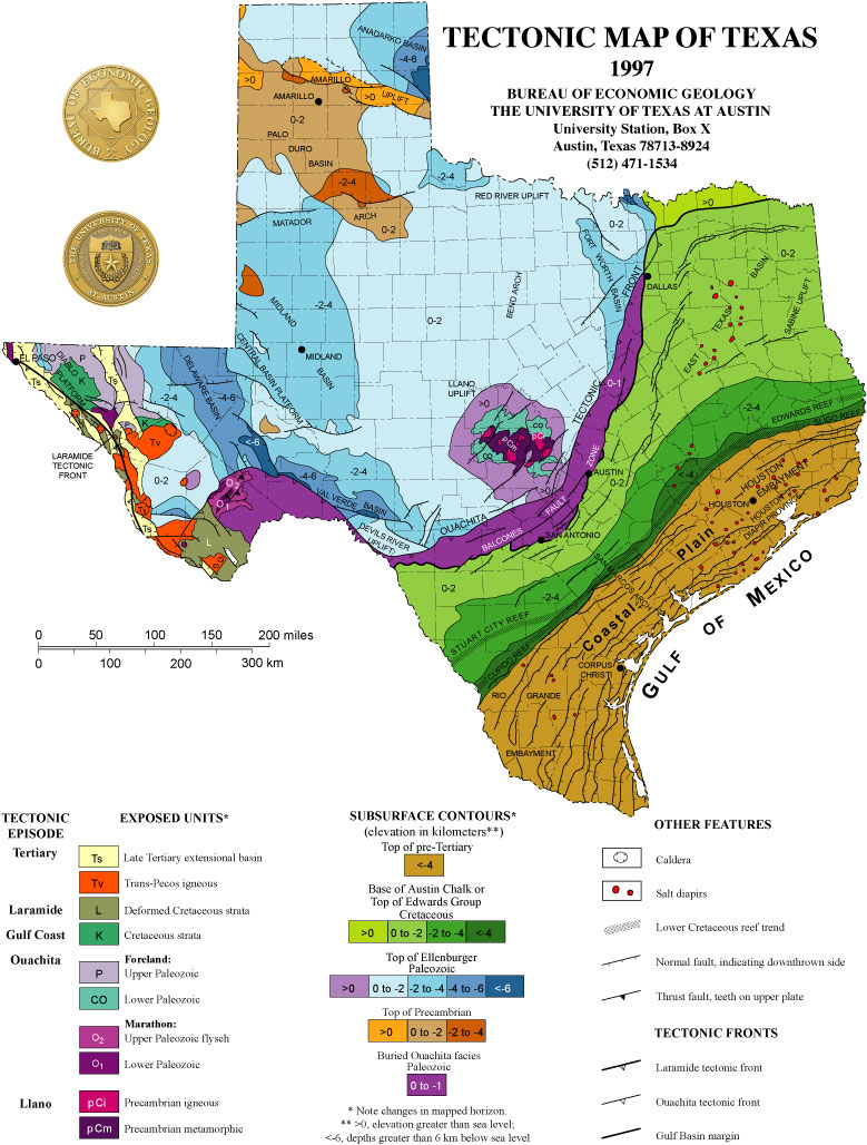
www.lib.utexas.edu...
Notice that the Houston area is slashed with scores of " Down thrown " faults, along with multiple " Salt Diapirs."
Additionally, East by Northeast ( San Antonio, Austin area going up to Dallas) is the Balconies Fault Zone as well as the Ouachita Tectonic Zone.
The Balconies Fault Zone and the Ouachita Tectonic Zone are geologically very close to Oklahoma City which has the Humbolt Fault Zone.
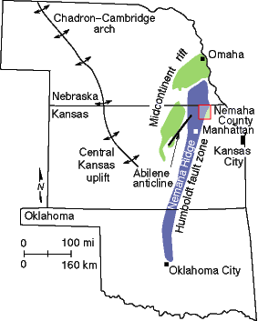
I don't know if this would trigger the New Madrid Fault line, but there has already been recent activity there, since the land fall of Hurricane Harvey.
a reply to: Violater1
First off, star and flag for math, and conversions
My opinion so far is that there could be a correlation, but it won't show up as a simple "mass-rainfall = earthquake risk."
I would think a lot would depend on what type of and location of land and plate, possible counterbalancing effects, etc. Meaning, there could well be a correlation, but there are a lot of competing factors, many of which we probably don't even know sound be considered, let alone have or can get measurements for.
Now, considering this - and I hope some University researchers with the funding to do so properly are, we (they) can start observing and gathering data, and possibly one day have a reasonable understanding about a collection of risk factors, which, when taken together, are meaningful and useful.
Perhaps one day we'll be hearing, "Hurricane BillyBob has the potential to reach category 5, and is expected to make landfall at New Orleans, but thankfully carries a very low ETR (Earthquake Triggering Risk), due to the [new stuff to learn] of the [new stuff to learn] coupled with the [more new stuff to learn.]
originally posted by: dogstar23
a reply to: Violater1
First off, star and flag for math, and conversions
My opinion so far is that there could be a correlation, but it won't show up as a simple "mass-rainfall = earthquake risk."
I would think a lot would depend on what type of and location of land and plate, possible counterbalancing effects, etc. Meaning, there could well be a correlation, but there are a lot of competing factors, many of which we probably don't even know sound be considered, let alone have or can get measurements for.
Now, considering this - and I hope some University researchers with the funding to do so properly are, we (they) can start observing and gathering data, and possibly one day have a reasonable understanding about a collection of risk factors, which, when taken together, are meaningful and useful.
Perhaps one day we'll be hearing, "Hurricane BillyBob has the potential to reach category 5, and is expected to make landfall at New Orleans, but thankfully carries a very low ETR (Earthquake Triggering Risk), due to the [new stuff to learn] of the [new stuff to learn] coupled with the [more new stuff to learn.]
Thank you.
It wasn't really difficult when all I did was research the who, what, why, and how.
But it did take some time.
Star back atcha.
a reply to: Violater1
The main problem I see here is that you're talking about the mass of water on a large area; a mass that is widely distributed and only temporary and not often in alignment with the direction of movement of the plates. I think that if there was any sort of correlation, we'd see it in India where they do have huge floods on an even larger scale than Houston and they have far more regular flood events. Admittedly the geology is not the same, but India is more geologically active than that area of Texas... so if you want to look for correlation, that would be the area to study.
Some of the other things you mention (salt dome collapse and sinkholes) have a different dynamic that leads to their collapse ... and they're not earthquakes.
Interesting idea but I don't think you'll see a correlation.
I could well be wrong. I'll know in a few years after I've taken some geology classes.
edit on 1-9-2017 by Byrd because: (no reason
given)
a reply to: jadedANDcynical
My understanding was the
sea basins of the entire world have a basalt layer of bedrock miles deep.
When I lived in California and experience being shaken out of bed one night, I
didn't understand that the severe earthquakes shook the ground hard, for
what seems like an eternity, several or more minutes. Tall buildingssway
several feet or more at the top and small building crumble.
In an earthquake prone area or in the surrounding areas, the effect of
billions of tons of water on the surface of the orb, on the crust, might
impress a downwards force on the crust below extending a 100 miles
deep, and thereby affecting and causing a seismic event.
I think Tsunami water exerts many quadrillions tons of force when it
comes in.
edit on 1-9-2017 by ThatHappened because: (no reason given)
new topics
-
God's Righteousness is Greater than Our Wrath
Religion, Faith, And Theology: 2 hours ago -
Electrical tricks for saving money
Education and Media: 5 hours ago -
VP's Secret Service agent brawls with other agents at Andrews
Mainstream News: 7 hours ago -
Sunak spinning the sickness figures
Other Current Events: 7 hours ago -
Nearly 70% Of Americans Want Talks To End War In Ukraine
Political Issues: 8 hours ago -
Late Night with the Devil - a really good unusual modern horror film.
Movies: 9 hours ago -
Cats Used as Live Bait to Train Ferocious Pitbulls in Illegal NYC Dogfighting
Social Issues and Civil Unrest: 11 hours ago
top topics
-
VP's Secret Service agent brawls with other agents at Andrews
Mainstream News: 7 hours ago, 9 flags -
Cats Used as Live Bait to Train Ferocious Pitbulls in Illegal NYC Dogfighting
Social Issues and Civil Unrest: 11 hours ago, 8 flags -
Electrical tricks for saving money
Education and Media: 5 hours ago, 4 flags -
HORRIBLE !! Russian Soldier Drinking Own Urine To Survive In Battle
World War Three: 15 hours ago, 3 flags -
Nearly 70% Of Americans Want Talks To End War In Ukraine
Political Issues: 8 hours ago, 3 flags -
Sunak spinning the sickness figures
Other Current Events: 7 hours ago, 3 flags -
Late Night with the Devil - a really good unusual modern horror film.
Movies: 9 hours ago, 2 flags -
The Good News According to Jesus - Episode 1
Religion, Faith, And Theology: 13 hours ago, 1 flags -
God's Righteousness is Greater than Our Wrath
Religion, Faith, And Theology: 2 hours ago, 0 flags
active topics
-
New whistleblower Jason Sands speaks on Twitter Spaces last night.
Aliens and UFOs • 55 • : baablacksheep1 -
VP's Secret Service agent brawls with other agents at Andrews
Mainstream News • 40 • : ThatSmellsStrange -
Cats Used as Live Bait to Train Ferocious Pitbulls in Illegal NYC Dogfighting
Social Issues and Civil Unrest • 20 • : Asher47 -
Nearly 70% Of Americans Want Talks To End War In Ukraine
Political Issues • 12 • : Asher47 -
Electrical tricks for saving money
Education and Media • 4 • : Lumenari -
DONALD J. TRUMP - 2024 Candidate for President - His Communications to Americans and the World.
2024 Elections • 514 • : WeMustCare -
The Acronym Game .. Pt.3
General Chit Chat • 7744 • : bally001 -
Truth Social goes public, be careful not to lose your money
Mainstream News • 128 • : Astyanax -
Sunak spinning the sickness figures
Other Current Events • 5 • : glen200376 -
SETI chief says US has no evidence for alien technology. 'And we never have'
Aliens and UFOs • 44 • : MikeDeGrasseTyson
24