It looks like you're using an Ad Blocker.
Please white-list or disable AboveTopSecret.com in your ad-blocking tool.
Thank you.
Some features of ATS will be disabled while you continue to use an ad-blocker.

Catastrophic rainfall predicted for TX, LA, gulf coast region.
page: 4share:
The NHC issued a full advisory just before 1pm CDT
The key points in the forecast discussion:
The key points in the forecast discussion:
1. Harvey has intensified rapidly, and is forecast to be a major
hurricane at landfall, bringing life-threatening storm surge,
rainfall, and wind hazards to portions of the Texas coast.
Preparations to protect life and property should be completed by
tonight, as tropical-storm-force winds will first arrive in the
hurricane and storm surge warning areas on Friday.
2. A Storm Surge Warning is in effect for much of the Texas coast.
Life-threatening storm surge flooding could reach heights of 6 to 12
feet above ground level at the coast between the north entrance of
the Padre Island National Seashore and Sargent. For a depiction of
areas at risk, see the Storm Surge Watch/Warning Graphic at
hurricanes.gov.
3. Life-threatening flooding is expected across much of the Texas
coast from heavy rainfall of 12 to 20 inches, with isolated amounts
as high as 30 inches, from Friday through early next week. Please
refer to products from your local National Weather Service office
and the NOAA Weather Prediction Center for more information on the
flooding hazard.
Nice knowing ya, Galveston and N'awlins!
Its been real, its been fun...but it aint been real fun!
Its been real, its been fun...but it aint been real fun!
Quick update:
My boss just came in and told me that the weather channel was indicating *massive* flooding all over the Texas Gulf Coast and everything from San Antonio south was going to be under feet of water.
Right before he came downstairs to tell me that, this happened:
I got an automated call from the Texas City Office of Emergency Management indicating that TC is under a Tropical Storm advisory, not a hurricane watch or warning. High amounts of rainfall are expected, but there is no danger of storm surge at this time. Evacuations are also not indicated at this time, however emergency plans should be reviewed.
For anyone who wants to sign up for the service, it can be done at the following page.
Texas City is on Galveston Bay and is home to a large number of chemical processing and petroleum refineries. If they are not worried, I am not worried.
Don't fall for the fear porn, but do use common sense!
a reply to: jadedANDcynical
Hey Jaded- The Weather Channel is telling viewers that storm surge in Galveston can between 6-12 ft. That's really concerning to me.
Maybe you should gather other sources before making any decisions before taking TC at their word. Just saying...
Don't want anything happening to you!
Update: Now they're saying storm surge for Galveston is 4 ft. Geez...They need to stop confusing us viewres! Sorry!
edit on 24-8-2017 by texasgirl because: (no reason given)
a reply to: texasgirl
Me neither.
The Poop Deck isn't closing, does that count a second source?
Bolivar Peninsula is under voluntary evacuation. If they're only calling for voluntary out there, then It's not going to be as bad as many think. Bolivar is less protected than Galveston and both are not much more than sandbars.
Where I am has always been considered the highest point in the county and has never flooded going back as far as Camille.
Taking precautions, yes.
Surrendering to doom, not so much.
Don't want anything happening to you!
Me neither.
The Poop Deck isn't closing, does that count a second source?
Bolivar Peninsula is under voluntary evacuation. If they're only calling for voluntary out there, then It's not going to be as bad as many think. Bolivar is less protected than Galveston and both are not much more than sandbars.
Where I am has always been considered the highest point in the county and has never flooded going back as far as Camille.
Taking precautions, yes.
Surrendering to doom, not so much.
The Latest: Harvey could bring up 20 inches of rain to Texas
Harvey intensifies to hurricane, likely a major Texas storm
More from Associated Press
Harvey intensifies to hurricane, likely a major Texas storm
CORPUS CHRISTI, Texas (AP) — Tropical Storm Harvey intensified Thursday into a hurricane that forecasters said would be the first major hurricane to hit the middle Texas coastline in nearly 15 years.
Sustained winds reached 80 mph (129 kph) more than a day before landfall was expected late Friday between Port O’Connor and Matagorda Bay, a 30-mile (48-kilometer) stretch of coastline about 70 miles (110 kilometers) northeast of Corpus Christi.
Forecasters said a “life-threatening” storm surge along with rains and wind were likely as Harvey was intensifying faster than previously forecast. A major hurricane means winds greater than 110 mph (177 kph).
As of midday Thursday, Harvey was about 340 miles (550 kilometers) southeast of Corpus Christi, moving to the north-northwest at about 10 mph (17 kph) .
More from Associated Press
edit on 24-8-2017 by DancedWithWolves because: (no reason given)
a reply to: jadedANDcynical
Okay, good to know. But it's always better to be safe than sorry, right?
They're now predicting a possible Cat 4 now. They flew into the storm and measured the intensity as possible 125 mph winds.
More doom porn for you. But it's TWC doing it, I swear!!
Okay, good to know. But it's always better to be safe than sorry, right?
They're now predicting a possible Cat 4 now. They flew into the storm and measured the intensity as possible 125 mph winds.
More doom porn for you. But it's TWC doing it, I swear!!
a reply to: texasgirl
TWC is the same place my boss heard about the entirety of south Texas being under water from San Antonio down and Dallas as being the only safe place.
So...
Now, I'm not saying there won't be damaging winds or heavy rains. There will be both, obviously.
But I don't think we're going to be redrawing coastal maps because of this storm which is the impression many news stations are giving.
edit
on 24-8-2017 by jadedANDcynical because: (no reason given)
Rainfall projections are being called “CATASTROPHIC” at forty-three inches (43″) [1100mm].
I think the term biblical is better
lol, thats crazy San Antonians(nites?) for you.
originally posted by: tigertatzen
originally posted by: Arnie123
It is a small world!! cool!!
originally posted by: tigertatzen
originally posted by: Arnie123
San Antonio here and we're expecting some of this action.
I may go streaking.
I'm in San Antonio too...small world. I've got people in Corpus and they're evacuating the base there and other places. I'm not looking forward to this...I'm on the south side of the soup bowl.
Northwest side here, Hueb and IH10. There is a huge flood zone on Vance Jackson. Stay safe.
You too! I'm smack in the middle of the downtown area near Southtown, right by the river. People are already getting drunk lol😜😜😜
Was at HEB earlier and people stocking on water like crazy.
edit on 24-8-2017 by Arnie123 because: heh
Jeff Masters at Weather Underground has an updated entry:
Dangerous, Rapidly Intensifying Harvey Expected to be a Major Hurricane
It is indeed ramping up, as they tend to do in the warm waters of the Gulf of Mexico.
Hurricane Warnings and Storm Surge Warnings are up for portions of the coast of Texas as rapidly intensifying Tropical Storm Harvey heads north-northwest at 10 mph over the Gulf of Mexico. Harvey was still a tropical depression at 10 pm CDT Wednesday night, but has explosively intensified in the early morning hours, and is almost certain to be a hurricane later today. Update: The National Hurricane Center (NHC) has upgraded Harvey to a Category 1 hurricane with 80-mph sustained winds as of noon CDT Thursday. If you live on the coast of Texas, please heed the advice of local emergency management officials, and get out today if you live in an evacuation zone. Tropical storm-force winds may arrive along the coast of Texas as early as 8 am CDT Friday, making evacuation difficult thereafter, according to the latest National Hurricane Center (NHC) forecast.
Dangerous, Rapidly Intensifying Harvey Expected to be a Major Hurricane
It is indeed ramping up, as they tend to do in the warm waters of the Gulf of Mexico.
a reply to: GuidedKill
No but if you are local maybe we could stage some supply drops through postal.
ATS has an amazing heart!
No but if you are local maybe we could stage some supply drops through postal.
ATS has an amazing heart!
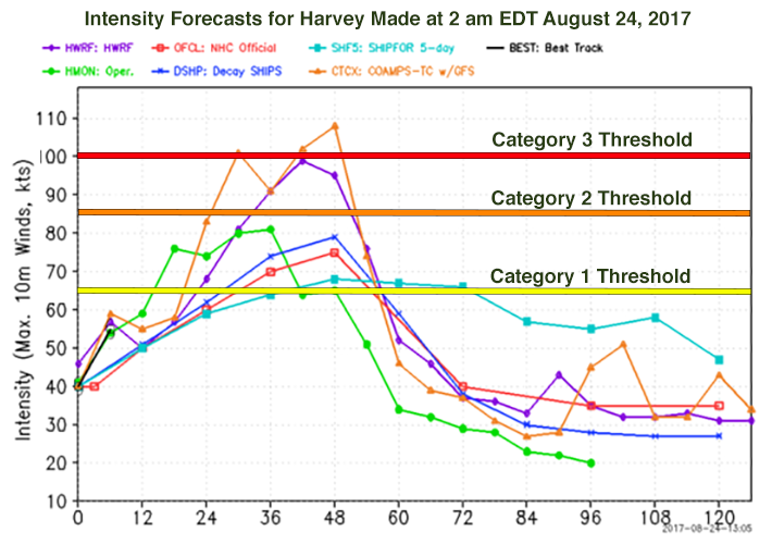
a reply to: jadedANDcynical
That intensity graph needs to be updated.
Here is the NHC's best guess:
That intensity graph needs to be updated.
Here is the NHC's best guess:
INIT 24/1800Z 24.4N 93.6W 75 KT 85 MPH
12H 25/0000Z 24.9N 94.2W 85 KT 100 MPH
24H 25/1200Z 26.0N 95.3W 105 KT 120 MPH
36H 26/0000Z 27.3N 96.3W 110 KT 125 MPH
48H 26/1200Z 28.3N 97.0W 100 KT 115 MPH...INLAND
72H 27/1200Z 29.0N 97.7W 40 KT 45 MPH...INLAND
96H 28/1200Z 28.5N 97.5W 35 KT 40 MPH...INLAND
120H 29/1200Z 28.5N 96.5W 30 KT 35 MPH...INLAND
edit on 24-8-2017 by jrod because: Ex
I just heard Joe Bastardi on FOX.
What he is worried about for folks in Texas isn't so much the strength of the hurricane, but the rain.
There is a blocking high pressure system off to the NW that is showing the potential to *keep* Harvey bumping around along the coast for a long time down there. If that happens, the rain will pile up.
I believe Bastardi, who has made a study of climate cycles and the weather patterns and phenomena they spawn, called this an unprecedented situation if this occurs and he recommends that folks not treat this like a standard Cat 3 to 4 storm it appears to be but something that could park on their front lawns and dump @ssloads of rain.
Understand, Joe Bastardi is someone who did not call Superstorm Sandy unprecedented! He knew it would be bad, but he had also seen storms like it on record in the past.
So, if you are at all unsure about your flood status ... I think you ought to really, truly think about leaving. If you think a 100 to 1,000 year event might flood you ... you better think about possibly leaving.
edit on 24-8-2017 by ketsuko because: (no reason given)
NHC Houston/Galveston specific information page here.
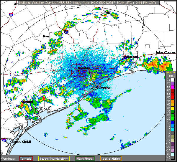
Current radar loop:
Voluntary Evacuation for Bolivar Peninsula
Current radar loop:
Voluntary Evacuation for Bolivar Peninsula
new topics
-
2024 Pigeon Forge Rod Run - On the Strip (Video made for you)
Automotive Discussion: 18 minutes ago -
Gaza Terrorists Attack US Humanitarian Pier During Construction
Middle East Issues: 44 minutes ago -
The functionality of boldening and italics is clunky and no post char limit warning?
ATS Freshman's Forum: 1 hours ago -
Meadows, Giuliani Among 11 Indicted in Arizona in Latest 2020 Election Subversion Case
Mainstream News: 2 hours ago -
Massachusetts Drag Queen Leads Young Kids in Free Palestine Chant
Social Issues and Civil Unrest: 2 hours ago -
Weinstein's conviction overturned
Mainstream News: 4 hours ago -
Supreme Court Oral Arguments 4.25.2024 - Are PRESIDENTS IMMUNE From Later Being Prosecuted.
Above Politics: 5 hours ago -
Krystalnacht on today's most elite Universities?
Social Issues and Civil Unrest: 5 hours ago -
Chris Christie Wishes Death Upon Trump and Ramaswamy
Politicians & People: 6 hours ago -
University of Texas Instantly Shuts Down Anti Israel Protests
Education and Media: 8 hours ago
top topics
-
Krystalnacht on today's most elite Universities?
Social Issues and Civil Unrest: 5 hours ago, 8 flags -
Weinstein's conviction overturned
Mainstream News: 4 hours ago, 6 flags -
Electrical tricks for saving money
Education and Media: 17 hours ago, 5 flags -
Supreme Court Oral Arguments 4.25.2024 - Are PRESIDENTS IMMUNE From Later Being Prosecuted.
Above Politics: 5 hours ago, 5 flags -
University of Texas Instantly Shuts Down Anti Israel Protests
Education and Media: 8 hours ago, 5 flags -
Meadows, Giuliani Among 11 Indicted in Arizona in Latest 2020 Election Subversion Case
Mainstream News: 2 hours ago, 4 flags -
Massachusetts Drag Queen Leads Young Kids in Free Palestine Chant
Social Issues and Civil Unrest: 2 hours ago, 3 flags -
Chris Christie Wishes Death Upon Trump and Ramaswamy
Politicians & People: 6 hours ago, 2 flags -
Any one suspicious of fever promotions events, major investor Goldman Sachs card only.
The Gray Area: 10 hours ago, 2 flags -
God's Righteousness is Greater than Our Wrath
Religion, Faith, And Theology: 14 hours ago, 1 flags
active topics
-
Gaza Terrorists Attack US Humanitarian Pier During Construction
Middle East Issues • 10 • : CarlLaFong -
Candidate TRUMP Now Has Crazy Judge JUAN MERCHAN After Him - The Stormy Daniels Hush-Money Case.
Political Conspiracies • 770 • : xuenchen -
University of Texas Instantly Shuts Down Anti Israel Protests
Education and Media • 177 • : theatreboy -
The functionality of boldening and italics is clunky and no post char limit warning?
ATS Freshman's Forum • 8 • : grey580 -
Breaking Baltimore, ship brings down bridge, mass casualties
Other Current Events • 487 • : Threadbarer -
2024 Pigeon Forge Rod Run - On the Strip (Video made for you)
Automotive Discussion • 1 • : chiefsmom -
Fossils in Greece Suggest Human Ancestors Evolved in Europe, Not Africa
Origins and Creationism • 84 • : whereislogic -
Ditching physical money
History • 21 • : SprocketUK -
Meadows, Giuliani Among 11 Indicted in Arizona in Latest 2020 Election Subversion Case
Mainstream News • 4 • : ElitePlebeian2 -
Is there a hole at the North Pole?
ATS Skunk Works • 38 • : Therealbeverage