It looks like you're using an Ad Blocker.
Please white-list or disable AboveTopSecret.com in your ad-blocking tool.
Thank you.
Some features of ATS will be disabled while you continue to use an ad-blocker.

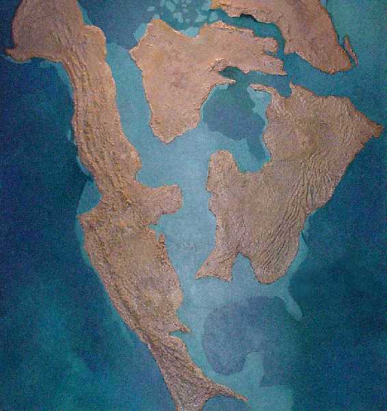
Future USA map?
page: 5share:
Originally posted by Macrento
(posted by theRiverGoddess)
What about the Edgar Cayce MAP??? Was that not very similar to the Gordon Micheal Scallion map? I think they are close enough for Goverment work.
In fact, close enough for hand grenades.
Scallion, too, like your beloved Op. Terra, looks to be a fraud...or maybe not. Anyway, Cayce talks about nearly all you see on that map:
1) "The greater change(...) in [North] America will be the North Atlantic Seaboard. Watch New York!"
2) "Many portions of the east coast will be disturbed as well as many portions of the west coast [and] the central portions of the United States."
3) "(...) lands will appear in the Atlantic as well as in the Pacific. And what is the coastline now of many a land will be the bed of the ocean. Even many of the battlefields of the present will be ocean, will be the seas, the bays, the lands over which the new order will carry on their trade as with one another."
4) "Portions of the now east coast of New York, or New York City itself, will in the main disappear. (...) the southern portions of Carolina, Georgia, these will disappear."
5) "The waters of the lakes [the Great Lakes] will empty into the Gulf [of Mexico] (...)."
6) "(...) among the safety lands (...) will be portions of what is now Ohio, Indiana and Illinois and much of the southern portion of Canada, and the eastern portion of Canada; while the western land, much of that is to be disturbed in this land, as, of course, much in other lands."
7) "There will be open waters in the northern portion of Greenland. There will be new lands seen off the Caribbean Sea and dry land will appear. South America shall be shaken from the uppermost portion to the end, and in the Antarctic off the Tierra del Fuego, land, and a strait with rushing waters."
8) "The greater portion of Japan must go into the sea. The upper portion of Europe will be changed as in the twinkling of an eye. Land will appear off the east coast of America."
That looks like a detailed description of the map.
Then there was this dream about his next reincarnation: "I had been born again in 2100 A.D. in Nebraska. The sea apparently covered all of the western part of the country, as the city where I lived was on the coast. (...) Water covered part of Alabama. Norfolk, Virginia, had become an immense seaport. New York had been destroyed either by war or an earthquake and was being rebuilt. Industries were scattered over the countryside. most of the houses were of glass."
(See Edgar Evans Cayce, Edgar Cayce on Atlantis, Paperback Library, N.Y., 1968, and M.A. Thurston, Ph.D., Visions and Prophecies for a New Age--Guidelines for the Future from Edgar Cayce and Other Psychics and Visionaries, A.R.E. Press (Edgar Cayce Foundation), Virginia Beach, 1981)
Great summary Macrento!
From what i've read in books and watching documentaries, the geographic pole shift (~ 2012) will lead to the 'revised' global map of the earth that Scallion and others drew. I've got several videos that overview Cayce's and Scallion's predictions and thought that it was interesting that they both predict land re-surfacing off the Southeast coast (would this be Poseidia that Cayce said is 'currently' beneath the Sargasso Sea and due to re-surface soon along with its temples & storehouses??). I've read several times from a scientific standpoint that the earth experiences geographic pole shifts on a more or less regular basis which sinks and elevates continents like a seasaw. Scallion mentions that by 2050 man will live to be 150 years old through a natural symbiotic relationship with the planet, not through medical advancements or changes in DNA. Also, we will all be vegetarians and there will be a total change in thought that facilitates peace through all species on the earth. IF this is all true we've got a LOT to look forward to.
I still have the desire to relocate to NM...........I am S L O W L Y saving up toward that end.
Look out 4 corners ATS folks.....I plan to join you.
edited to make sure I wrote MORE than one line.
[edit on 17-4-2008 by theRiverGoddess]
Look out 4 corners ATS folks.....I plan to join you.
edited to make sure I wrote MORE than one line.
[edit on 17-4-2008 by theRiverGoddess]
reply to post by theRiverGoddess
I too saw Ancient Prophecies and Gordon Michael Scallion and his map. I would like to see that same map that he showed THEN to us...not the new ones. How can I get to see that same map again??? Somebody inform me please? Thank you, Rebecca Smith or [email protected]
I too saw Ancient Prophecies and Gordon Michael Scallion and his map. I would like to see that same map that he showed THEN to us...not the new ones. How can I get to see that same map again??? Somebody inform me please? Thank you, Rebecca Smith or [email protected]
reply to post by theRiverGoddess
I was thinking about this map in light of recent events (floods etc) Google the name Gordon-Michael Scallion. I think it was him who drew the map. I found a copy here,
www.coasttocoastam.com...
Hope this helps!
I was thinking about this map in light of recent events (floods etc) Google the name Gordon-Michael Scallion. I think it was him who drew the map. I found a copy here,
www.coasttocoastam.com...
Hope this helps!
What I would really like to see a map of is the projected zones of ash etc, if yellowstone were to erupt.
Ama
Ama
Haven't agreed too much with the maps but what is going to happen is the devide south of the SLR and east of the mud will move about 9" in 8 1/2
minutes causing havoc on the east coast.
minutes causing havoc on the east coast.
reply to post by ICWhen
What are the SLR and the mud?
Ive thought the Mississippi is whats going to cut the USA in half way moreso than it already does.
What are the SLR and the mud?
Ive thought the Mississippi is whats going to cut the USA in half way moreso than it already does.
i think the "4-corners" area has been deemed a Safe area, because it is around the historical land of the Hopi. and the Hopi are going to be around
for the 5th world, so the 4-corners must be a Safe area...
but i think a lot of the earth-shift folklore/legend had its inspiration from the verses of Revelation 16: 18 through 20
which predicts a 'earthquake' that breaks the world (or civilization) into thirds, and every island and mountain 'fled' or was no longer.
The word 'fled' implies lateral movement... and thus the story of the earth's crust sliding became plausable with the mix of science and faith.
i'm more attuned to a movement of the magnetic poles or even their reversal... with the Physical Earth staying in its orbit and keeping its axis spin ->> as opposed to
a slippage of the total outer skin of the planet sliding over the inner mantle or core of the planet. but weird things do happen
Originally posted by amatrine
What I would really like to see a map of is the projected zones of ash etc, if yellowstone were to erupt.
Are you SURE you really want to know that?
Well since you asked... I just happen to have that handy...

Seems Montana thinks they are ready to handle it
The State of Montana Multi-Hazard Mitigation Plan and Statewide Hazard Assessment October 2004
3-79
3.3.6 Volcanic Eruptions
PDF Report
As to water levels... lets have a look at the past when the ice was melted...
Ancient Sea Levels
North America, Cretaceous Period
Ancient Sea levels
North America, Jurassic

Now you can disagree with the maps and projections all you like... but all you have to do is look around where you live... If you have sedimentary rocks and fossil beds... guess what?
THAT AREA WAS UNDER WATER before the ice formed...
Hip waders anyone?
Oh and if your all thinking of moving to Nevada... the boys at Nellis will block the pass on one side and Edwards has the other side covered
To keep an eye on whats shaking around the world...
IRIS seismic Monitor
www.iris.edu...
Yellowstone Volcano Observatory
volcanoes.usgs.gov...
USGS Recent Quakes List - updated continuously
earthquake.usgs.gov...
Monitoring Volcanic Unrest at Long Valley Caldera, California
lvo.wr.usgs.gov...
IRIS seismic Monitor
www.iris.edu...
Yellowstone Volcano Observatory
volcanoes.usgs.gov...
USGS Recent Quakes List - updated continuously
earthquake.usgs.gov...
Monitoring Volcanic Unrest at Long Valley Caldera, California
lvo.wr.usgs.gov...
You know I never really knew about Long lake Caldera until I looked up this yellow stone stuff...
Since its closer to Vegas well hehehe
Seems the Park rangers have closed most of the area due to its unstable nature and when I checked I get THIS JUST YESTERDAY !!!!!
LONG VALLEY OBSERVATORY INFORMATION RELEASE
Saturday, June 28, 2008 08:16 PDT (Saturday, June 28, 2008 15:16 UTC)
Seems its been shaking from the 22nd and still had 11 aftershocks TODAY as I write this
YIKES talk about a "Timely Event"
LONG VALLEY OBSERVATORY CURRENT STATUS REPORT
volcano.wr.usgs.gov...
[edit on 29-6-2008 by zorgon]
Since its closer to Vegas well hehehe
Seems the Park rangers have closed most of the area due to its unstable nature and when I checked I get THIS JUST YESTERDAY !!!!!
LONG VALLEY OBSERVATORY INFORMATION RELEASE
Saturday, June 28, 2008 08:16 PDT (Saturday, June 28, 2008 15:16 UTC)
LONG VALLEY VOLCANIC CENTER VOLCANO (CAVW#1203-14-)
37.70°N 118.87°W, Summit Elevation 11122 ft (3390 m)
Volcano Alert Level: NORMAL
Aviation Color Code: GREEN
A magnitude M=4.3 earthquake at 7:44 AM (PDT) this morning (June 28) was located in the Sierra Nevada just south of Long Valley caldera (2 miles east of Convict Lake, 8 miles WNW of Tom's Place). This earthquake will have produced perceptible shaking throughout the Mammoth Lakes area. As of this update, it has produced only a few, small aftershocks, the largest of which was a M=1.3 earthquake at 8:03 AM.
-----
The Long Valley Observatory (LVO) monitors and studies earthquakes, ground deformation, degassing, and other types of geologic unrest in and around the Long Valley Caldera. The 15 by 30 km Long Valley Caldera was formed during an eruption 760,000 years ago and is located 20 km south of Mono Lake along the east side of the Sierra Nevada in east-central California. There have been multiple smaller eruptions since the caldera-forming eruption with the most recent occurring 250 years ago in Mono Lake at the north end of Mono-Inyo Craters volcanic chain. LVO is one of the five USGS Volcano Observatories that monitor volcanoes within the United States for science and public safety.
Seems its been shaking from the 22nd and still had 11 aftershocks TODAY as I write this
YIKES talk about a "Timely Event"
LONG VALLEY OBSERVATORY CURRENT STATUS REPORT
volcano.wr.usgs.gov...
[edit on 29-6-2008 by zorgon]
Originally posted by theRiverGoddess
ahh geee Ive been on ATS a long time now it seems like.
Wow just noticed a three year gap here No wonder you asked for a transfusion
reply to post by zorgon
THANKS SO MUCH Zorgon, your information is seriously awesome!
I was not really seeking a transfusion for this thread as I was seeking this map information for my own peace of mind.....I feel like this is information we really should have and be apprised of..
..AND your so excellent that you could even share the caldera maps information.......stars at you my friend!!
Thank you so much for sharing you knowledge on this thread.....
Hi River Goddess
great thread.. I really have nothing to offer to it right now but
I wanted to say that you have the COOLEST Avatar .
"Bilder Burgers -- only 500 Million will Be served" I almost died laughing(even though its not really funny)... yep..a cool avatar......
[edit on 4-7-2008 by Maya432]
great thread.. I really have nothing to offer to it right now but
I wanted to say that you have the COOLEST Avatar .
"Bilder Burgers -- only 500 Million will Be served" I almost died laughing(even though its not really funny)... yep..a cool avatar......
[edit on 4-7-2008 by Maya432]
lol Maya THANKS................
This thread is an important one IMO and I do not understand the lack of stars or interest.......
oh well.
SOME of us will survive..............
This thread is an important one IMO and I do not understand the lack of stars or interest.......
oh well.
SOME of us will survive..............
Possible Future Maps of the USA
looking at this particular map, there is NO WAY water will be covering the mile high rockies in colorado. for water that high to happen would soak up the rest of the US map.
doesn't seem practical.
EDIT: wow on the the other maps from zorgon. i've always wanted to see the region in utah where i used to camp, at Luna Mesa. it was a giant reef. amazing.
[edit on 7/4/2008 by zooplancton]
hmmm seems TN is out of all the map areas. i guess im kinda happy now i move to TN. eventually ill have beach front property or a big lake but that
seems to be it.
Originally posted by zooplancton
i've always wanted to see the region in utah where i used to camp, at Luna Mesa. it was a giant reef. amazing.
[edit on 7/4/2008 by zooplancton]
Whereabouts is Luna Mesa? sounds like a cool place to check out.....
I have found ancient shells all over this state....and fish bones in stone....
[edit on 5-7-2008 by theRiverGoddess]
reply to post by theRiverGoddess
I agree 100%. In fact, God is not happy that they are trying to profit off of this and in return will surprise them with the irony of a different map so that the sellers find themselves in a world of ca-ca! Bad karma, that's all I have to say!
I agree 100%. In fact, God is not happy that they are trying to profit off of this and in return will surprise them with the irony of a different map so that the sellers find themselves in a world of ca-ca! Bad karma, that's all I have to say!
new topics
-
Meadows, Giuliani Among 11 Indicted in Arizona in Latest 2020 Election Subversion Case
Mainstream News: 34 minutes ago -
Massachusetts Drag Queen Leads Young Kids in Free Palestine Chant
Social Issues and Civil Unrest: 49 minutes ago -
Weinstein's conviction overturned
Mainstream News: 2 hours ago -
Supreme Court Oral Arguments 4.25.2024 - Are PRESIDENTS IMMUNE From Later Being Prosecuted.
Above Politics: 3 hours ago -
Krystalnacht on today's most elite Universities?
Social Issues and Civil Unrest: 3 hours ago -
Chris Christie Wishes Death Upon Trump and Ramaswamy
Politicians & People: 4 hours ago -
University of Texas Instantly Shuts Down Anti Israel Protests
Education and Media: 6 hours ago -
Any one suspicious of fever promotions events, major investor Goldman Sachs card only.
The Gray Area: 8 hours ago
top topics
-
VP's Secret Service agent brawls with other agents at Andrews
Mainstream News: 17 hours ago, 11 flags -
Krystalnacht on today's most elite Universities?
Social Issues and Civil Unrest: 3 hours ago, 7 flags -
Weinstein's conviction overturned
Mainstream News: 2 hours ago, 6 flags -
Electrical tricks for saving money
Education and Media: 16 hours ago, 5 flags -
Supreme Court Oral Arguments 4.25.2024 - Are PRESIDENTS IMMUNE From Later Being Prosecuted.
Above Politics: 3 hours ago, 5 flags -
University of Texas Instantly Shuts Down Anti Israel Protests
Education and Media: 6 hours ago, 3 flags -
Massachusetts Drag Queen Leads Young Kids in Free Palestine Chant
Social Issues and Civil Unrest: 49 minutes ago, 2 flags -
Meadows, Giuliani Among 11 Indicted in Arizona in Latest 2020 Election Subversion Case
Mainstream News: 34 minutes ago, 2 flags -
Any one suspicious of fever promotions events, major investor Goldman Sachs card only.
The Gray Area: 8 hours ago, 2 flags -
God's Righteousness is Greater than Our Wrath
Religion, Faith, And Theology: 13 hours ago, 1 flags
active topics
-
Chris Christie Wishes Death Upon Trump and Ramaswamy
Politicians & People • 15 • : diaclonethunder -
Massachusetts Drag Queen Leads Young Kids in Free Palestine Chant
Social Issues and Civil Unrest • 5 • : Texastruth2 -
Candidate TRUMP Now Has Crazy Judge JUAN MERCHAN After Him - The Stormy Daniels Hush-Money Case.
Political Conspiracies • 759 • : xuenchen -
University of Texas Instantly Shuts Down Anti Israel Protests
Education and Media • 142 • : FlyersFan -
Weinstein's conviction overturned
Mainstream News • 16 • : WeMustCare -
VP's Secret Service agent brawls with other agents at Andrews
Mainstream News • 51 • : grey580 -
New whistleblower Jason Sands speaks on Twitter Spaces last night.
Aliens and UFOs • 60 • : baablacksheep1 -
Nearly 70% Of Americans Want Talks To End War In Ukraine
Political Issues • 85 • : Consvoli -
Graham Hancock being proven right all along about ancient humans in America.
Ancient & Lost Civilizations • 106 • : JonnyC555 -
Supreme Court Oral Arguments 4.25.2024 - Are PRESIDENTS IMMUNE From Later Being Prosecuted.
Above Politics • 47 • : matafuchs