It looks like you're using an Ad Blocker.
Please white-list or disable AboveTopSecret.com in your ad-blocking tool.
Thank you.
Some features of ATS will be disabled while you continue to use an ad-blocker.

High Definition Panoramic Photo of Mars - NASA
page: 16
share:
This year, on March 24th, NASA's Rover "Curiosity" made a very high definition panoramic photo and sent it back to Earth. Here is a NASA YouTube video
documenting this event. Along with that video is the panoramic picture as it was released to the public in early May, a few weeks ago. This photo is
highly detailed and good to use as a desktop background if you'd like.
photojournal.jpl.nasa.gov...
photojournal.jpl.nasa.gov...
edit on 24-5-2017 by Profundity because: spelling
a reply to: Profundity
not photos but images , I just love how they merge in the subsurface micro displacements.
not photos but images , I just love how they merge in the subsurface micro displacements.
Very good for the near to middle distance, after that it gets a bit blocky...enough to get the Pareidolia blues going.
Here is the long path that this rover traveled current through yesterday. (Sol 1705)
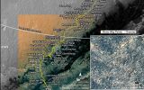

Where is curiosity? official site
marsmobile.jpl.nasa.gov...
Where is curiosity? official site
marsmobile.jpl.nasa.gov...
Love these panoramas from Curiosity. There's lots more psoted here a while ago: www.abovetopsecret.com...
What's cool is that one can create such panoramas themselves from the raw Curiosity images using software Microsoft ICE.
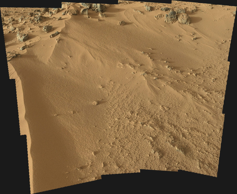
Here's a partial mosaic of martian terrain at "Rocknest" taken in Nov 2012:
What's cool is that one can create such panoramas themselves from the raw Curiosity images using software Microsoft ICE.
Here's a partial mosaic of martian terrain at "Rocknest" taken in Nov 2012:
Brilliant images. Shows how barren the place truly is.
And the genius of mankind when they work towards something together
Hopefully this won't get derailed by people who swear they can see a womble or something in the background
And the genius of mankind when they work towards something together
Hopefully this won't get derailed by people who swear they can see a womble or something in the background
I had no idea you could manually move the image around for an actual 360 view until I accidentally click-dragged on it. Then I was all "WHOA, holy s#
this is cool!"
I just caught on to something YT's probably had for a while now, haven't I?
I just caught on to something YT's probably had for a while now, haven't I?
originally posted by: Nyiah
I had no idea you could manually move the image around for an actual 360 view until I accidentally click-dragged on it. Then I was all "WHOA, holy s# this is cool!"
I just caught on to something YT's probably had for a while now, haven't I?
Yes, Youtube and Facebook, including live streaming.
Mind you, 360 videos are usually blurry, so for static images like this one, it's always better to see the original panorama: www.360cities.net...
edit on 25-5-2017 by wildespace because: (no reason given)
Mars Curiosity Rover mission updates:
(mars.jpl.nasa.gov...)
Today's article:
Sols 1707-1708: When Mars Gives You Lemons, Calibrate Your Instruments
Written by Michael Battalio on 05.25.2017
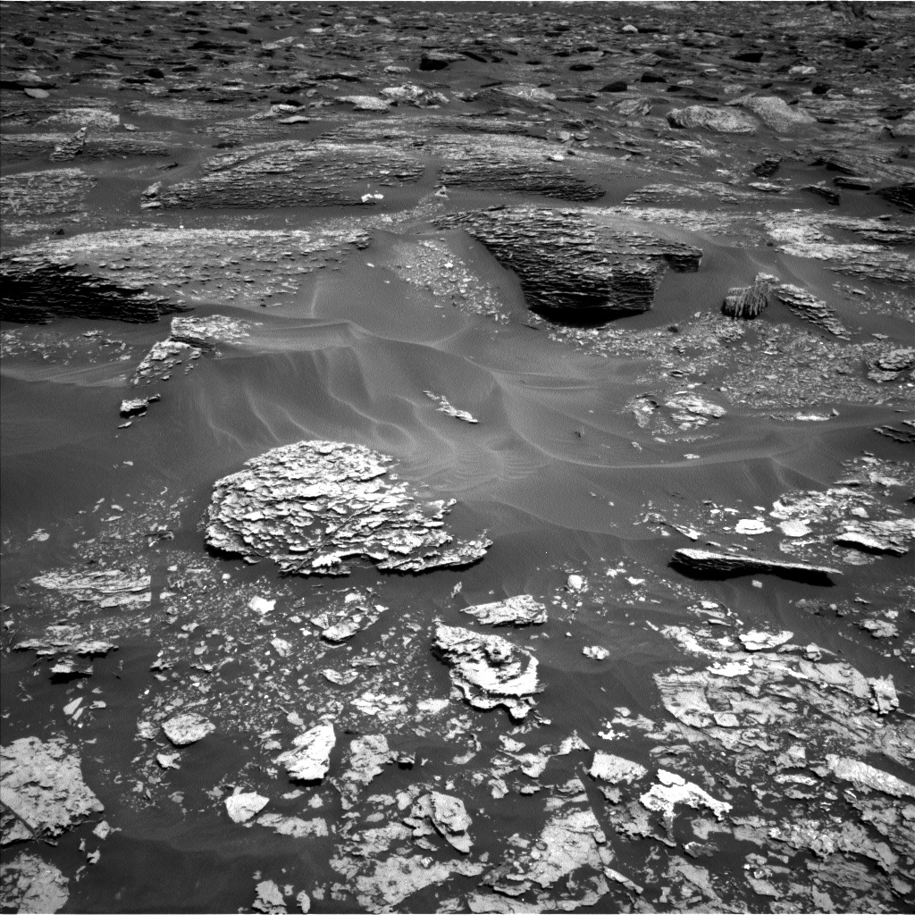
After a 14.6 m drive, the GEO group decided against arm activities due to a lack of compelling targets and in deference to making the next drive longer. Thusly, GEO science activities relied on Mastcam and ChemCam. On Sol 1707, ChemCam will capture a raster of the "White Cap Mountain" bedrock target (the white bedrock left of center in the bottom quarter of the above Navcam image), as well as a patch of dark undisturbed soil called "French Hill Pond." Mastcam will document all of the ChemCam targets and will image "Googings Ledge" (the large, darker bedrock just above and right of image center) and "The Twinnies" (the shadowed bedrock exposure cut off on the far left), which are sedimentary members of the Murray formation, and "Soward Island," which has exposed bedrock layers. After a planned 30 m drive, ChemCam will perform an AEGIS automated activity, and Navcam will document Curiosity's new position. SAM will perform a methane dual enrichment activity on Sol 1709, which will compare a methane-enriched atmospheric sample to a non-enriched sample.
I served in the ENV STL role, and today was one of the more hectic ENV operations days I have planned. It was a plan full of trade-offs. When SAM takes atmospheric methane or oxygen measurements, ENV likes to obtain a ChemCam passive sky observation within a few sols for an independent comparison. However, the times initially available in the plan around mid-sol to place a passive sky were not compatible with possible pointing azimuths, as we are so close to the new year (northern hemisphere spring equinox). In anticipation of potential power restrictions in the weekend plan, we attempted a long morning imaging suite a couple of sols early, which would include a passive sky measurement; however, we were forced to defer those plans due to power restrictions in the current plan. Instead of losing the science time altogether, we noticed that the mid-sol time was compatible for taking a ChemCam calibration measurement. This calibration will be taken on Sol 1708 in preparation for the next passive sky. This just proves that while doing science on another planet can be frustrating at times, it is always rewarding.
On top of the ChemCam calibration, the ENV group planned several Mastcam and Navcam observations. On Sol 1707, Mastcam will capture tau and LOS measurements to assess the amount of dust in the atmosphere. Also on Sol 1707, Navcam will capture a late afternoon zenith cloud movie. A 30-minute Navcam dust devil movie will be taken around noon on Sol 1708. REMS will capture the standard top of the hour 5 minute observations and 19 hour-long observation blocks, which will include observations during the ingest times of the SAM methane activity. DAN will take approximately 9 hours of passive and 20 minutes of post-drive active observations.
(mars.jpl.nasa.gov...)
Today's article:
Sols 1707-1708: When Mars Gives You Lemons, Calibrate Your Instruments
Written by Michael Battalio on 05.25.2017
After a 14.6 m drive, the GEO group decided against arm activities due to a lack of compelling targets and in deference to making the next drive longer. Thusly, GEO science activities relied on Mastcam and ChemCam. On Sol 1707, ChemCam will capture a raster of the "White Cap Mountain" bedrock target (the white bedrock left of center in the bottom quarter of the above Navcam image), as well as a patch of dark undisturbed soil called "French Hill Pond." Mastcam will document all of the ChemCam targets and will image "Googings Ledge" (the large, darker bedrock just above and right of image center) and "The Twinnies" (the shadowed bedrock exposure cut off on the far left), which are sedimentary members of the Murray formation, and "Soward Island," which has exposed bedrock layers. After a planned 30 m drive, ChemCam will perform an AEGIS automated activity, and Navcam will document Curiosity's new position. SAM will perform a methane dual enrichment activity on Sol 1709, which will compare a methane-enriched atmospheric sample to a non-enriched sample.
I served in the ENV STL role, and today was one of the more hectic ENV operations days I have planned. It was a plan full of trade-offs. When SAM takes atmospheric methane or oxygen measurements, ENV likes to obtain a ChemCam passive sky observation within a few sols for an independent comparison. However, the times initially available in the plan around mid-sol to place a passive sky were not compatible with possible pointing azimuths, as we are so close to the new year (northern hemisphere spring equinox). In anticipation of potential power restrictions in the weekend plan, we attempted a long morning imaging suite a couple of sols early, which would include a passive sky measurement; however, we were forced to defer those plans due to power restrictions in the current plan. Instead of losing the science time altogether, we noticed that the mid-sol time was compatible for taking a ChemCam calibration measurement. This calibration will be taken on Sol 1708 in preparation for the next passive sky. This just proves that while doing science on another planet can be frustrating at times, it is always rewarding.
On top of the ChemCam calibration, the ENV group planned several Mastcam and Navcam observations. On Sol 1707, Mastcam will capture tau and LOS measurements to assess the amount of dust in the atmosphere. Also on Sol 1707, Navcam will capture a late afternoon zenith cloud movie. A 30-minute Navcam dust devil movie will be taken around noon on Sol 1708. REMS will capture the standard top of the hour 5 minute observations and 19 hour-long observation blocks, which will include observations during the ingest times of the SAM methane activity. DAN will take approximately 9 hours of passive and 20 minutes of post-drive active observations.
new topics
-
HORRIBLE !! Russian Soldier Drinking Own Urine To Survive In Battle
World War Three: 1 hours ago -
Bobiverse
Fantasy & Science Fiction: 4 hours ago -
Florida man's trip overseas ends in shock over $143,000 T-Mobile phone bill
Social Issues and Civil Unrest: 4 hours ago -
Former Labour minister Frank Field dies aged 81
People: 6 hours ago -
SETI chief says US has no evidence for alien technology. 'And we never have'
Aliens and UFOs: 8 hours ago -
This is our Story
General Entertainment: 10 hours ago
top topics
-
President BIDEN Vows to Make Americans Pay More Federal Taxes in 2025 - Political Suicide.
2024 Elections: 13 hours ago, 16 flags -
One Flame Throwing Robot Dog for Christmas Please!
Weaponry: 17 hours ago, 6 flags -
Florida man's trip overseas ends in shock over $143,000 T-Mobile phone bill
Social Issues and Civil Unrest: 4 hours ago, 6 flags -
SETI chief says US has no evidence for alien technology. 'And we never have'
Aliens and UFOs: 8 hours ago, 6 flags -
Don't take advantage of people just because it seems easy it will backfire
Rant: 17 hours ago, 4 flags -
Ditching physical money
History: 17 hours ago, 4 flags -
Former Labour minister Frank Field dies aged 81
People: 6 hours ago, 4 flags -
Bobiverse
Fantasy & Science Fiction: 4 hours ago, 3 flags -
This is our Story
General Entertainment: 10 hours ago, 3 flags -
Ode to Artemis
General Chit Chat: 13 hours ago, 3 flags
active topics
-
-@TH3WH17ERABB17- -Q- ---TIME TO SHOW THE WORLD--- -Part- --44--
Dissecting Disinformation • 645 • : Thoughtful3 -
American Government to Sanction Israel Defence Force in the West Bank
Middle East Issues • 53 • : yuppa -
Florida man's trip overseas ends in shock over $143,000 T-Mobile phone bill
Social Issues and Civil Unrest • 5 • : Consvoli -
Breaking Baltimore, ship brings down bridge, mass casualties
Other Current Events • 478 • : IndieA -
Russia Ukraine Update Thread - part 3
World War Three • 5726 • : stu119 -
Thousands Of Young Ukrainian Men Trying To Flee The Country To Avoid Conscription And The War
Other Current Events • 129 • : yuppa -
One Flame Throwing Robot Dog for Christmas Please!
Weaponry • 10 • : ATruGod -
HORRIBLE !! Russian Soldier Drinking Own Urine To Survive In Battle
World War Three • 8 • : Astyanax -
New whistleblower Jason Sands speaks on Twitter Spaces last night.
Aliens and UFOs • 51 • : Ophiuchus1 -
The Reality of the Laser
Military Projects • 40 • : Zaphod58
6