It looks like you're using an Ad Blocker.
Please white-list or disable AboveTopSecret.com in your ad-blocking tool.
Thank you.
Some features of ATS will be disabled while you continue to use an ad-blocker.

* SEVERE WEATHER ALERT * - Tornado Outbreak Likely in Southern & Central Plains [PDS]
page: 1share:
Well it's time for another Severe Weather Alert, ATS...
as It appears an extremely dangerous situation is currently unfolding in the Southern and Central Plains.
PDS Tornado Watch Issued:
Tornado Outbreak Likely Thursday as Next Round of Severe Thunderstorms Moves Into the Plains
___
Convective Outlook May 18, 2017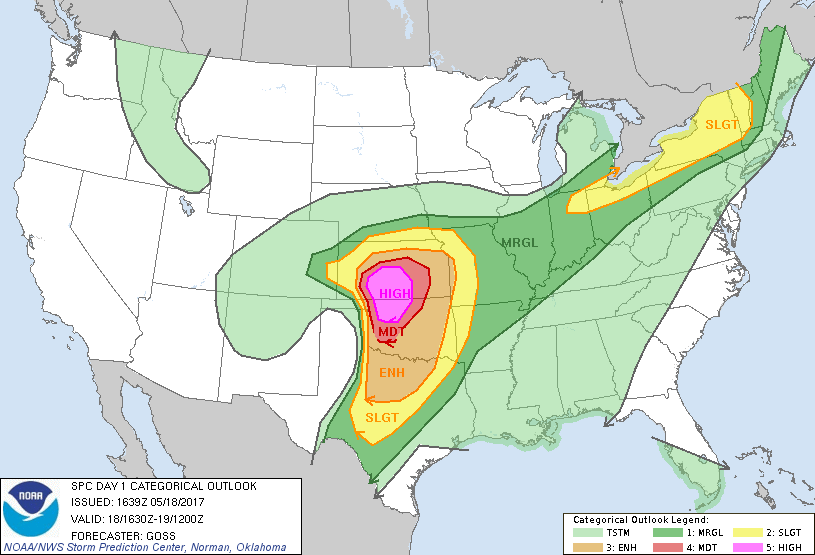
___
Tornado Probabilities May 18, 2017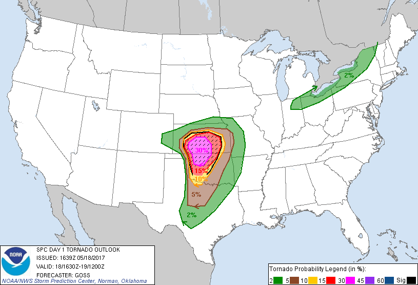 www.spc.noaa.gov...
___
Conditions at the moment appear to be ideal for an extremely dangerous weather event to occur within the outlined areas.
As we near peak heating, we can expect things to intensify and it is imperative for everyone in these areas to take necessary precautions and prepare immediately.
It is currently 1:45pm CDT in the risk area; peak heating usually occurs around 4pm....
That's NOT to say tornadoes can't form before or after this time frame...
___
Public Severe Weather Outlook (PWO) May 18, 2017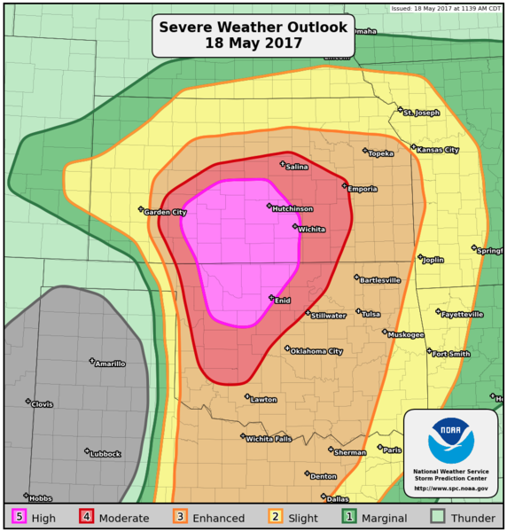
___
Updates will follow as this situation develops,
and as always your contributions and reports are more than welcome.
Stay safe everyone and please be sure to monitor your local weather stations if you live in these areas_
All the Best.
as It appears an extremely dangerous situation is currently unfolding in the Southern and Central Plains.
PDS Tornado Watch Issued:
Tornado Outbreak Likely Thursday as Next Round of Severe Thunderstorms Moves Into the Plains
weather.com...
A PDS watch means that conditions are ripe for tornadoes, including strong tornadoes, and other forms of severe weather including giant hail and significant straight-line winds.
The ingredients are in place for dangerous thunderstorms to develop Thursday afternoon into evening. This has prompted the Storm Prediction Center (SPC) to issue a rare high risk area for severe thunderstorms for portions of central and southern Kansas into northern and western Oklahoma for Thursday. This is the area where widespread severe thunderstorms are expected, of which some storms could be particularly intense and long-lived.
___
Convective Outlook May 18, 2017
www.spc.noaa.gov...
...SUMMARY... An outbreak of severe thunderstorms with tornadoes, very large hail and wind damage is expected to develop across parts of the southern and central Plains from this afternoon into this evening and overnight. Some strong, long-lived tornadoes are expected, along with hail to near 4 inches in diameter, over parts of Kansas and Oklahoma. Large hail, tornadoes and wind damage also will be possible outside of these areas across parts of the southern and central Plains. Locally damaging gusts and sporadic hail also are expected across parts of the lower Great Lakes region to western New England this afternoon and early evening.
___
Tornado Probabilities May 18, 2017
___
Conditions at the moment appear to be ideal for an extremely dangerous weather event to occur within the outlined areas.
As we near peak heating, we can expect things to intensify and it is imperative for everyone in these areas to take necessary precautions and prepare immediately.
It is currently 1:45pm CDT in the risk area; peak heating usually occurs around 4pm....
That's NOT to say tornadoes can't form before or after this time frame...
___
Public Severe Weather Outlook (PWO) May 18, 2017
PUBLIC SEVERE WEATHER OUTLOOK
NWS STORM PREDICTION CENTER NORMAN OK
1144 AM CDT THU MAY 18 2017
...Outbreak of tornadoes and severe thunderstorms expected over parts of the central and southern Plains this afternoon and tonight...
* LOCATIONS... Southern and central Kansas Western and central Oklahoma North Texas
* HAZARDS... Numerous tornadoes, several intense and long track Widespread large hail, some baseball size Scattered damaging winds, some hurricane force
* SUMMARY... An outbreak of severe thunderstorms with tornadoes, very large hail and wind damage is expected to develop across parts of the southern and central Plains from this afternoon into this evening and overnight. Some strong, long-lived tornadoes are expected, along with hail to near 4 inches in diameter, over parts of Kansas and Oklahoma. Large hail, tornadoes and wind damage also will be possible outside of these areas across parts of the southern and central Plains. Locally damaging gusts and sporadic hail also are expected across parts of the lower Great Lakes region to western New England this afternoon and early evening.
___
Updates will follow as this situation develops,
and as always your contributions and reports are more than welcome.
Stay safe everyone and please be sure to monitor your local weather stations if you live in these areas_
All the Best.
edit on 18-5-2017 by iunlimited491 because: (no reason given)
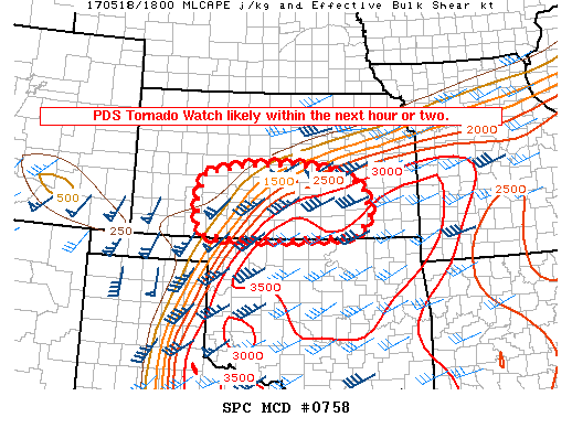
Mesoscale Discussion 758
www.spc.noaa.gov...
Mesoscale Discussion 0758
NWS Storm Prediction Center Norman OK
0200 PM CDT Thu May 18 2017
Areas affected...Portions of southern/central Kansas Concerning...Severe potential...Tornado Watch likely
Valid 181900Z - 182030Z
Probability of Watch Issuance...95 percent
SUMMARY...Severe thunderstorms will develop across parts of southern and central Kansas this afternoon and evening, with an attendant threat of tornadoes (some of which may be strong), very large hail, and damaging winds. A PDS Tornado Watch will likely be issued within the next hour or two.
DISCUSSION...Surface analyses indicate a warm front is slowly advancing northward across southern Kansas this afternoon. To the south of this front, ample boundary-layer heating has resulted in considerable mixed-layer buoyancy, with CAPE values upwards of 2500-3000 J/kg. As forcing for ascent continues to increase over the region, low-level moisture will continue to stream north/northwest, promoting a further increase in buoyancy over southern Kansas. With 850-700mb southerly flow strengthening during the late afternoon/evening, warm advection near/south of the warm front will lead to a blossoming of convection over the region. Indeed, current visible satellite data show a developing cumulus field beneath a higher-level canopy. Severe thunderstorms will likely develop out of this cumulus field as it continues to advance north/northwest ahead of the dry line and south of the warm front.
Cells near the warm front will interact with more backed low-level flow, enhancing storm-relative helicity. In turn, with continued north/northwestward transport of rich boundary-layer moisture, the potential exists for a few discrete cells with organized/strong low-level mesocyclones. A tornado threat would likely evolve, with the potential for a few stronger tornadoes, considering the ample low-level helicity. Steep mid-level lapse rates and considerable effective shear will encourage a threat of very large hail. Moreover, somewhat straight mid-level hodographs could yield upscale growth through the evening. While this would reduce the tornado threat some, merging cold pools (aided by dry air aloft) would offer the potential for a few significant severe gusts. In turn, with the potential for all higher-end severe hazards, a PDS Tornado Watch will likely be issued within the next hour or two.
It seems that the Karma works fast today, is that Karmas reward for that actual Syria thing?
I'm driving to florida tonight from Ohio- so hopefully the roads aren't too bad as things come through- if they do while we are still on the road.
With that being said, that's a minor issue compared to what the people in the plains are facing tonight.
Wishing them the best safety.
-Alee
Wishing them the best safety.
-Alee
Also does anyone know any good storm chaser livestream websites??
Ever since TWC shut down the storm chasing page- I haven't been able to find anything that seems to function decently.
-Alee
Ever since TWC shut down the storm chasing page- I haven't been able to find anything that seems to function decently.
-Alee
I've been keeping an eye on this since I have lots of friends and family in the line of fire and it could work its way up to where I'm at as the
evening progresses.
Right now, I feel particularly bad for my sister. She's smack in the bull's-eye, but even worse, her father-in-law has a severe weather phobia and NO sense of direction, so any tornado, no matter where it hits, will be on his doorstep, their doorstep, "OH NOES, WEESA GONNA DIE!" on the phone to her all night long. So while I am worried for everyone's sake, I feel bad for her because I know she's got a long night on her hands trying to keep him calmed down.
Right now, I feel particularly bad for my sister. She's smack in the bull's-eye, but even worse, her father-in-law has a severe weather phobia and NO sense of direction, so any tornado, no matter where it hits, will be on his doorstep, their doorstep, "OH NOES, WEESA GONNA DIE!" on the phone to her all night long. So while I am worried for everyone's sake, I feel bad for her because I know she's got a long night on her hands trying to keep him calmed down.
originally posted by: DerBeobachter
It seems that the Karma works fast today, is that Karmas reward for that actual Syria thing?
Or it could just be a spring thing.
originally posted by: DerBeobachter
It seems that the Karma works fast today, is that Karmas reward for that actual Syria thing?
Given the actual lack of people in most of that area? If Karma is actually taking a shot, she has bad aim.
Posting a couple live storm chasing links...
LIVE Storm Chasing Link: SevereStudios
LIVE Storm Chasing Link: StormViewLive
TVN was shutdown at the end of 2015, however, these other sites consist of the same chasers and some new ones...
they also provide good content and interactive chat...
There are other live chase sites available as well if you wish to follow along.
edit on 18-5-2017 by iunlimited491 because: (no reason
given)
a reply to: NerdGoddess
www.severestudios.com...
www.stormviewlive.com...
www.severestudios.com...
www.stormviewlive.com...
edit on 18-5-2017 by iunlimited491 because: (no reason given)
Still just a wee bit early. Some severe storms getting going, but they really don't start to get serious usually until after 3pm most of the time.
originally posted by: NerdGoddess
Also does anyone know any good storm chaser livestream websites??
It sucked when TVN closed down as it was really great
There's only really Stormviewlive and Severestudios now and some of the chasers stream live on youtube like Daniel Shaw who usually catches some decent footage. I like to watch Mike Phelps when he's live as well on stormscapelive as he talks a lot about the weather systems and how it they all work so it's educational
Accuweather Radar
It's not storm chaser, but Accuweather has up links to local radars from Oklahoma up through Kansas on it's radar page.
You can monitor everything from Amarillo, TX, to Pueblo, CO, to Shreveport, LA, to Topeka, KS, to Fort Smith, AR, and Springfield, MO, on there.
So if you want to see a particular local radar, you should be able to find it.
edit on 18-5-2017 by AbbKatt22 because: (mistakenly logged out of og account and logged into separate account with saved password before
making post
edit on 18-5-2017 by AbbKatt22 because: (no reason given)
a reply to: iunlimited491
News9 is another good source for the OK storms, they've usually got about 3 chaser feeds as well as the helicopter watching the storms
But yeah wish TVN was back instead of everyone being scattered around different sites
News9 is another good source for the OK storms, they've usually got about 3 chaser feeds as well as the helicopter watching the storms
But yeah wish TVN was back instead of everyone being scattered around different sites
radar.weather.gov...
^Radar imagery from Norman, OK, showing multiple tornado warnings in affect.
radar.weather.gov...
^ Velocity radar for those who wish to follow the rotation and motion of these storms...
[for velocity radar imagery I recommend clicking off Topo, Cities, and Highways_ as well as speeding up the loop... as it may be easier to detect rotation]
edit on 18-5-2017 by iunlimited491 because: (no reason given)
Tornado Watch issued for northeastern Kansas/Northwestern Missouri. Some storms starting to fire off to the west/southwest of the KC metro. They are
around the old Sunflower Ammo plant.
fox4kc.com...
Things may get hot up here sooner than expected.
fox4kc.com...
Things may get hot up here sooner than expected.
edit on 18-5-2017 by ketsuko because: (no reason given)
National Radar Loop - May 18, 2017 20:00
UTC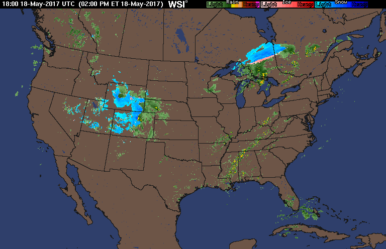 www.intellicast.com...
Storms firing pretty quick and intensifying down in OK...
Storms firing pretty quick and intensifying down in OK...
new topics
-
Is the origin for the Eye of Horus the pineal gland?
General Conspiracies: 56 minutes ago -
Man sets himself on fire outside Donald Trump trial
Mainstream News: 1 hours ago -
Biden says little kids flip him the bird all the time.
2024 Elections: 1 hours ago -
The Democrats Take Control the House - Look what happened while you were sleeping
US Political Madness: 1 hours ago -
Sheetz facing racial discrimination lawsuit for considering criminal history in hiring
Social Issues and Civil Unrest: 1 hours ago -
In an Historic First, In N Out Burger Permanently Closes a Location
Mainstream News: 3 hours ago -
MH370 Again....
Disaster Conspiracies: 4 hours ago -
Are you ready for the return of Jesus Christ? Have you been cleansed by His blood?
Religion, Faith, And Theology: 6 hours ago -
Chronological time line of open source information
History: 7 hours ago -
A man of the people
Diseases and Pandemics: 9 hours ago
top topics
-
Israeli Missile Strikes in Iran, Explosions in Syria + Iraq
World War Three: 17 hours ago, 19 flags -
In an Historic First, In N Out Burger Permanently Closes a Location
Mainstream News: 3 hours ago, 14 flags -
The Democrats Take Control the House - Look what happened while you were sleeping
US Political Madness: 1 hours ago, 8 flags -
Thousands Of Young Ukrainian Men Trying To Flee The Country To Avoid Conscription And The War
Other Current Events: 14 hours ago, 7 flags -
Iran launches Retalliation Strike 4.18.24
World War Three: 17 hours ago, 6 flags -
12 jurors selected in Trump criminal trial
US Political Madness: 17 hours ago, 4 flags -
4 plans of US elites to defeat Russia
New World Order: 10 hours ago, 4 flags -
A man of the people
Diseases and Pandemics: 9 hours ago, 4 flags -
Man sets himself on fire outside Donald Trump trial
Mainstream News: 1 hours ago, 4 flags -
Biden says little kids flip him the bird all the time.
2024 Elections: 1 hours ago, 3 flags
active topics
-
4 plans of US elites to defeat Russia
New World Order • 35 • : Oldcarpy2 -
12 jurors selected in Trump criminal trial
US Political Madness • 74 • : Xtrozero -
Man sets himself on fire outside Donald Trump trial
Mainstream News • 10 • : andy06shake -
George Knapp AMA on DI
Area 51 and other Facilities • 26 • : nerbot -
Sheetz facing racial discrimination lawsuit for considering criminal history in hiring
Social Issues and Civil Unrest • 6 • : chiefsmom -
Is the origin for the Eye of Horus the pineal gland?
General Conspiracies • 1 • : ARM19688 -
Thousands Of Young Ukrainian Men Trying To Flee The Country To Avoid Conscription And The War
Other Current Events • 25 • : twistedpuppy -
Silent Moments --In Memory of Beloved Member TDDA
Short Stories • 46 • : Encia22 -
The Democrats Take Control the House - Look what happened while you were sleeping
US Political Madness • 15 • : matafuchs -
Are you ready for the return of Jesus Christ? Have you been cleansed by His blood?
Religion, Faith, And Theology • 17 • : TheValeyard