It looks like you're using an Ad Blocker.
Please white-list or disable AboveTopSecret.com in your ad-blocking tool.
Thank you.
Some features of ATS will be disabled while you continue to use an ad-blocker.

Long exposure photographs of Groom Lake airspace
page: 131
share:
www.lazygranch.com...
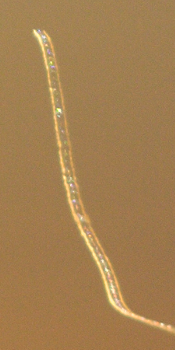
I've done long exposure photographs of Janets landing at Groom Lake from Tikaboo Peak. (Tikaboo is the spot to view Groom Lake from "free" territory.) Realizing not everyone can make the excursion to Tikaboo, and it is getting really unlikely that the base will fly test aircraft when people are on the peak, I decided to see what could be documented from less adventurous locations.
I did a series of 10 minute exposures from Queen City Summit, a location north east of Groom Lake. However the Power Line Overlook would work, or hills on the west side of Groom Lake.
The idea is to capture trails of the aircraft made by the navigation lights.
The conclusion for this series of images is nothing but boring old Janets were flying.
Very nice! They seem to have a very steep climb from the photos. Almost hard to believe they are Janet's. I'm trying to understand the angular drops
too. They also seem like they are about to do a header into the ground.
Nice work though indeed!
Nice work though indeed!
a reply to: spiritualarchitect
Depends I guess.
They probably want to get as high as they can as fast as they can to avoid detection.
Depends I guess.
They probably want to get as high as they can as fast as they can to avoid detection.
originally posted by: grey580
a reply to: spiritualarchitect
Depends I guess.
They probably want to get as high as they can as fast as they can to avoid detection.
www.wired.com...
Contrails, or in this case navigation marker trails, when they are in line with the observer, can look like missile launches. This happens often enough around Los Angeles. (The rest of the West Coast is too foggy.)
If you did the experiment from the Power Line Overlook, you would see the climb from the side. I have Groom Landing done from Tikaboo using a 100mm lens.
www.abovetopsecret.com...
a reply to: Salander
I've scanned the base for years. Mostly the Janets, but there is some simplex RF on the ground that you can hear from Tikaboo. It is very hard to hear transmissions from free territory around the range due to hills. All you can monitor are airband frequencies. The base repeaters have been encrypted for years.
I've scanned the base for years. Mostly the Janets, but there is some simplex RF on the ground that you can hear from Tikaboo. It is very hard to hear transmissions from free territory around the range due to hills. All you can monitor are airband frequencies. The base repeaters have been encrypted for years.
originally posted by: gariac
www.lazygranch.com...
I've done long exposure photographs of Janets landing at Groom Lake from Tikaboo Peak. (Tikaboo is the spot to view Groom Lake from "free" territory.) Realizing not everyone can make the excursion to Tikaboo, and it is getting really unlikely that the base will fly test aircraft when people are on the peak, I decided to see what could be documented from less adventurous locations.
I did a series of 10 minute exposures from Queen City Summit, a location north east of Groom Lake. However the Power Line Overlook would work, or hills on the west side of Groom Lake.
The idea is to capture trails of the aircraft made by the navigation lights.
The conclusion for this series of images is nothing but boring old Janets were flying.
Very nice!
I did the same thing last trip, from the valley right after Queen City Summit, where I camped. I will dig up the pictures, I did see some aircraft lights.
edit on 14-4-2017 by FosterVS because: (no reason given)
originally posted by: WhyDidIJoin
a reply to: gariac
I don't see any con trails or exhaust. Can this be explained?
You don't always have contrails. It depends on conditions. In actual battle, you really rather not have a contrail. ;-) Remember these planes don't fly very high.
contrailscience.com...
I have a photo of a B2 somewhere with a contrail. Not very stealthly!
a reply to: gariac
www.lazygranch.com...
Looking at the trails again, it became obvious to me that the arrival trails were so bright because they had their landing light on. In the link above, you can see a short section of the trail that is formed just by navigation lights, but then the trail goes bright white when the landing light is turned on.
new topics
-
Intro once again
Introductions: 1 hours ago -
University student disciplined after saying veganism is wrong and gender fluidity is stupid
Education and Media: 2 hours ago -
Geddy Lee in Conversation with Alex Lifeson - My Effin’ Life
People: 3 hours ago -
God lived as a Devil Dog.
Short Stories: 3 hours ago -
Police clash with St George’s Day protesters at central London rally
Social Issues and Civil Unrest: 5 hours ago -
TLDR post about ATS and why I love it and hope we all stay together somewhere
General Chit Chat: 6 hours ago -
Hate makes for strange bedfellows
US Political Madness: 8 hours ago -
Who guards the guards
US Political Madness: 10 hours ago
top topics
-
Hate makes for strange bedfellows
US Political Madness: 8 hours ago, 15 flags -
Who guards the guards
US Political Madness: 10 hours ago, 13 flags -
whistleblower Captain Bill Uhouse on the Kingman UFO recovery
Aliens and UFOs: 17 hours ago, 12 flags -
Police clash with St George’s Day protesters at central London rally
Social Issues and Civil Unrest: 5 hours ago, 8 flags -
TLDR post about ATS and why I love it and hope we all stay together somewhere
General Chit Chat: 6 hours ago, 5 flags -
University student disciplined after saying veganism is wrong and gender fluidity is stupid
Education and Media: 2 hours ago, 4 flags -
Has Tesla manipulated data logs to cover up auto pilot crash?
Automotive Discussion: 12 hours ago, 2 flags -
God lived as a Devil Dog.
Short Stories: 3 hours ago, 2 flags -
Geddy Lee in Conversation with Alex Lifeson - My Effin’ Life
People: 3 hours ago, 2 flags -
Intro once again
Introductions: 1 hours ago, 2 flags
active topics
-
-@TH3WH17ERABB17- -Q- ---TIME TO SHOW THE WORLD--- -Part- --44--
Dissecting Disinformation • 629 • : fringeofthefringe -
Terrifying Encounters With The Black Eyed Kids
Paranormal Studies • 63 • : Consvoli -
TLDR post about ATS and why I love it and hope we all stay together somewhere
General Chit Chat • 7 • : Consvoli -
Mood Music Part VI
Music • 3089 • : TheWoker -
University student disciplined after saying veganism is wrong and gender fluidity is stupid
Education and Media • 10 • : Consvoli -
Intro once again
Introductions • 1 • : Encia22 -
Hate makes for strange bedfellows
US Political Madness • 33 • : DBCowboy -
Breaking Baltimore, ship brings down bridge, mass casualties
Other Current Events • 466 • : IndieA -
Remember These Attacks When President Trump 2.0 Retribution-Justice Commences.
2024 Elections • 45 • : TzarChasm -
My wife just had a very powerful prophetic dream - massive war in Israel...
The Gray Area • 13 • : BukkaWukka
31