It looks like you're using an Ad Blocker.
Please white-list or disable AboveTopSecret.com in your ad-blocking tool.
Thank you.
Some features of ATS will be disabled while you continue to use an ad-blocker.

Full Earth view from ISS Cupola Impossible 100 percent Fake
page: 20share:
originally posted by: andrew778
a reply to: WaxingGibbons
You really can't grasp how the picture was taken. Educate yourself before you make more of a fool of yourself
Too late...
Good grief what a silly thread.Look at the solar panel in the lower left quadrant: www.issphotolibrary.com...
It is curved. The photo is taken with a fisheye lens. Just like this. www.techietonics.com...
Hopefully you can see that the lens is showing a 360-degree view?
It is curved. The photo is taken with a fisheye lens. Just like this. www.techietonics.com...
Hopefully you can see that the lens is showing a 360-degree view?
The fish eye lens argument seems real to me.That makes sense capturing light making it appear distorted.Maybe NASA forgets to mention other kinds of
lenses can distort the size of the Earth from certain distances.
originally posted by: Jobeycool
The fish eye lens argument seems real to me.That makes sense capturing light making it appear distorted.Maybe NASA forgets to mention other kinds of lenses can distort the size of the Earth from certain distances.
It isn't exactly accurate to say that the fisheye lens was distorting the "size of the Earth". That's because the OPs image does not show the entire full disk of the Earth -- big or little. What the OP's image showed was just the small part of the Earth that was visible out to the horizon line as seen 200 miles up from the ISS. What the fisheye lens does is show that horizon line in a 360 degree image, which make the horizon line look like a circle, just like this image (which I posted before):
It's not completely accurate to say that this image posted above is distorting the size of the Earth; it's simply distorting the visible horizon. However, this image above is the same concept of the OP's image -- only the OP's 360 degree fisheye image of the visible horizon is taken from 200 miles up while the 360 degree fisheye image of the visible horizon posted above is from only a few hundred feet up.
edit on 27/3/2017 by Soylent Green Is People because: (no reason given)
a reply to: WaxingGibbons
Looooooooooollllll!!!!!
OP that is not the entire earth. The dark ring around the picture of the earth is part of the portal the picture is taken through.
Classic internet dumbass moment. Thanks for the hearty laugh OP, nearly peed my pants when I finally realized what you were talking about.
Looooooooooollllll!!!!!
OP that is not the entire earth. The dark ring around the picture of the earth is part of the portal the picture is taken through.
Classic internet dumbass moment. Thanks for the hearty laugh OP, nearly peed my pants when I finally realized what you were talking about.
edit on 27-3-2017 by Dawgishly because: (no reason given)
a reply to: Dawgishly
In the future you *might* want to take some time and skim through the thread before accusing someone else of a 'Classic internet dumbass moment'. The dark ring is most definitely NOT a part of the portal, if you look at the pictures you will see parts of the space station in this dark ring. The image was take with a fisheye lens, scroll up through the thread and you will see it discussed at length.
In the future you *might* want to take some time and skim through the thread before accusing someone else of a 'Classic internet dumbass moment'. The dark ring is most definitely NOT a part of the portal, if you look at the pictures you will see parts of the space station in this dark ring. The image was take with a fisheye lens, scroll up through the thread and you will see it discussed at length.
originally posted by: Dawgishly
a reply to: WaxingGibbons
Looooooooooollllll!!!!!
OP that is not the entire earth. The dark ring around the picture of the earth is part of the portal the picture is taken through.
Classic internet dumbass moment. Thanks for the hearty laugh OP, nearly peed my pants when I finally realized what you were talking about.
Not really -- the darkness directly above the blue Earth is the blackness of space. That is the "sky" (which is black space) above the visible horizon.
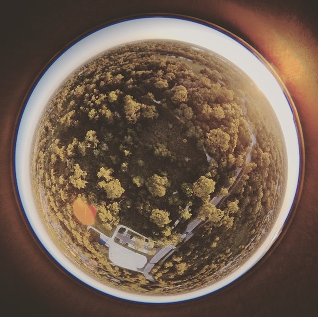
What is confusing some people is the fact that the horizon line forms a complete 360 degree circle -- which is a result of the 360 degree fisheye lens that was used.
Look at the circular image of a slightly wooded area of land in my post directly above your post. The bright ring above the trees on the horizon line all around that image is the sky. The horizon and the sky are in a circle because of the 360 degree fisheye lens.
That is the same type of image as the one in the OP -- but the OP's image is from higher up, so it sees a little more. The OPs image also shows a portion of Earth out to the horizon line, with the "sky" above the horizon line being the blackness of space instead of bright atmosphere.
But it's the same type of image, just one higher than the other.
edit on 27/3/2017 by Soylent Green Is People because: (no reason given)
A very cool one from the astronaut's twitterfeed:
twitpic.com...
If you look at the size and shape of the cupola windows
upload.wikimedia.org...
It becomes clear it's the lens that does it.
twitpic.com...
If you look at the size and shape of the cupola windows
upload.wikimedia.org...
It becomes clear it's the lens that does it.
On the twitter page for one of the images a comment gives the locations:
twitpic.com...
In order to get the same perspective as the view in the photo, you have to do this to the view:

(I had to turn Google Earth upside down to make it work )
In other words it's not looking straight down when you look at the windows around the edge of the photo, it's looking to the side.
twitpic.com...
This pic has been taken over the Atlantlic, south of Montevideo. The center piece shows the coast South America, the SW windows two lakes at Rio Negro in Argentina. The bottom piece: coastline at Cabo Blanco in Argentina.
In order to get the same perspective as the view in the photo, you have to do this to the view:
(I had to turn Google Earth upside down to make it work )
In other words it's not looking straight down when you look at the windows around the edge of the photo, it's looking to the side.
originally posted by: OneBigMonkeyToo
A very cool one from the astronaut's twitterfeed:
twitpic.com...
If you look at the size and shape of the cupola windows
upload.wikimedia.org...
It becomes clear it's the lens that does it.
The picture itself is inconsistent, in that the Earth is the only thing we are seeing the horizon, an interesting effect.
a reply to: WaxingGibbons
Put a dome at the intersect of those two red lines and you have your answer, it is indeed possible to see the edges of the earth. In the picture I suppose what you are seeing is a very small section of the earth in the central window, and a very small section of the earths edges, so in reality you are correct, you are not seeing the whole earth, not to mention half the earth is on the other side (duh), you are seeing a cool effect from bending light. Light looking at a straw in a cup of water.
Put a dome at the intersect of those two red lines and you have your answer, it is indeed possible to see the edges of the earth. In the picture I suppose what you are seeing is a very small section of the earth in the central window, and a very small section of the earths edges, so in reality you are correct, you are not seeing the whole earth, not to mention half the earth is on the other side (duh), you are seeing a cool effect from bending light. Light looking at a straw in a cup of water.
a reply to: WaxingGibbons
You can see its not the entire earth. Looking at the photo it shows south amarica. Since all the other continents are missing it's safe to say it's an optical illusion caused by the shape of the wondows.
You can see its not the entire earth. Looking at the photo it shows south amarica. Since all the other continents are missing it's safe to say it's an optical illusion caused by the shape of the wondows.
edit on 3/27/17 by dragonridr because: (no reason given)
Good points brought up here..remember that as I look down from 2m the earth is a perfect disk..but I dont see much certainly not any ocean. Any
fisheye camera will make the earth appear round, but what will be missing(assuming no fakery) is a larger percentage of the actual earth. As the
viewer goes to infinity, he sees, exactly 50% of the surface.
originally posted by: LostonEarth
This topic got 20 pages. What a waste.
Half of it was his denials. Some of us really do want to help, but you can't help someone who is being willfully ignorant. It's like telling an alcoholic to cut back on drinking. Until they realize they have a problem, you're wasting your time.
Got ya
originally posted by: Soylent Green Is People
originally posted by: Jobeycool
The fish eye lens argument seems real to me.That makes sense capturing light making it appear distorted.Maybe NASA forgets to mention other kinds of lenses can distort the size of the Earth from certain distances.
It isn't exactly accurate to say that the fisheye lens was distorting the "size of the Earth". That's because the OPs image does not show the entire full disk of the Earth -- big or little. What the OP's image showed was just the small part of the Earth that was visible out to the horizon line as seen 200 miles up from the ISS. What the fisheye lens does is show that horizon line in a 360 degree image, which make the horizon line look like a circle, just like this image (which I posted before):
Image Source: markmarano.com...
It's not completely accurate to say that this image posted above is distorting the size of the Earth; it's simply distorting the visible horizon. However, this image above is the same concept of the OP's image -- only the OP's 360 degree fisheye image of the visible horizon is taken from 200 miles up while the 360 degree fisheye image of the visible horizon posted above is from only a few hundred feet up.
So, we buy ya books....
We friggin send ya to school......
And...and you come out unable to grasp the basics, so now what we have here ..
Is a shift that has become obvious,,,kinda blaringly...some of us in the know have to just give some of our brothers over to a reprobate mind...so we will just let it drop and hang our heads....why do we even use words anymore....no one is able to listen, cool though
edit on 27-3-2017 by
GBP/JPY because: (no reason given)
new topics
-
Who guards the guards
US Political Madness: 1 hours ago -
Has Tesla manipulated data logs to cover up auto pilot crash?
Automotive Discussion: 2 hours ago -
whistleblower Captain Bill Uhouse on the Kingman UFO recovery
Aliens and UFOs: 7 hours ago -
1980s Arcade
General Chit Chat: 10 hours ago -
Deadpool and Wolverine
Movies: 10 hours ago -
Teenager makes chess history becoming the youngest challenger for the world championship crown
Other Current Events: 11 hours ago
top topics
-
Lawsuit Seeks to ‘Ban the Jab’ in Florida
Diseases and Pandemics: 15 hours ago, 20 flags -
Starburst galaxy M82 - Webb Vs Hubble
Space Exploration: 17 hours ago, 13 flags -
CIA botched its handling of sexual assault allegations, House intel report says
Breaking Alternative News: 12 hours ago, 8 flags -
15 Unhealthiest Sodas On The Market
Health & Wellness: 17 hours ago, 6 flags -
whistleblower Captain Bill Uhouse on the Kingman UFO recovery
Aliens and UFOs: 7 hours ago, 6 flags -
1980s Arcade
General Chit Chat: 10 hours ago, 4 flags -
Deadpool and Wolverine
Movies: 10 hours ago, 3 flags -
Teenager makes chess history becoming the youngest challenger for the world championship crown
Other Current Events: 11 hours ago, 3 flags -
Who guards the guards
US Political Madness: 1 hours ago, 1 flags -
Has Tesla manipulated data logs to cover up auto pilot crash?
Automotive Discussion: 2 hours ago, 0 flags
active topics
-
Scientists Say Even Insects May Be Sentient
Science & Technology • 54 • : seekshelter -
-@TH3WH17ERABB17- -Q- ---TIME TO SHOW THE WORLD--- -Part- --44--
Dissecting Disinformation • 610 • : Justoneman -
Lawsuit Seeks to ‘Ban the Jab’ in Florida
Diseases and Pandemics • 24 • : VariedcodeSole -
23,000 Dead People Registered Within a Two Week Period In One State
US Political Madness • 40 • : IndieA -
whistleblower Captain Bill Uhouse on the Kingman UFO recovery
Aliens and UFOs • 7 • : pianopraze -
CIA botched its handling of sexual assault allegations, House intel report says
Breaking Alternative News • 6 • : watchitburn -
They Killed Dr. Who for Good
Rant • 63 • : grey580 -
House Overwhelmingly Passes Funding for Ukraine, Israel and Taiwan
US Political Madness • 58 • : IndieA -
A Better Choice I Think
2024 Elections • 30 • : SchrodingersRat -
Michael Avenatti Says He Will Testify FOR Trump
US Political Madness • 60 • : Justoneman