It looks like you're using an Ad Blocker.
Please white-list or disable AboveTopSecret.com in your ad-blocking tool.
Thank you.
Some features of ATS will be disabled while you continue to use an ad-blocker.

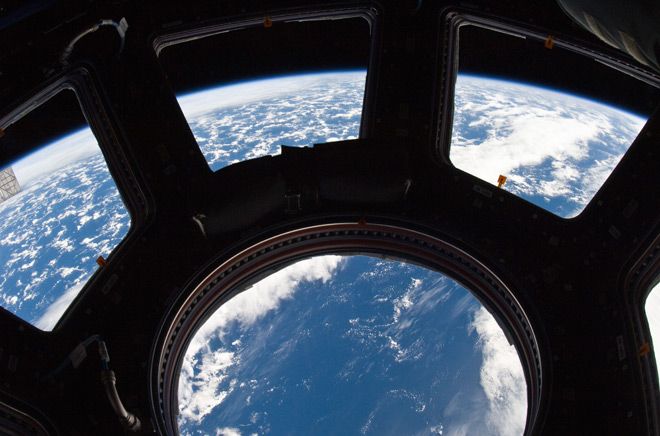
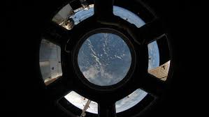
Full Earth view from ISS Cupola Impossible 100 percent Fake
page: 16share:
originally posted by: WaxingGibbons
a reply to: Zaphod58
It is clearly not the frame, this would make the windows twice as narrow as they obviously are.......
Like I said, straight denial of obvious and simple facts........
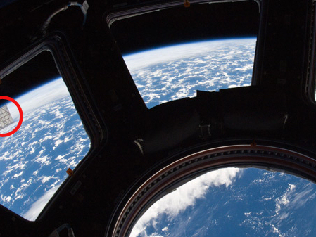
On a slightly different note....what's the object i've highlighted in the red circle?
Doesn't look like a Solar Panel to me.
What else could it be?
originally posted by: WaxingGibbons
a reply to: TarzanBeta
I don't own such cameras, you are the professional here.
What about this pic.
It shows the curvature of the Earth matching up to the curvature of the 2m diameter window at an 400 km altitude. Obviously not a fish eye lense.
So how can they match up? At that distance it is impossible to have them match up.
You need to look more carefully. The curvature of the earth is greater in this picture.
a reply to: TarzanBeta
I can show you many more pics where it follows the curve of the cupola windows without a fisheye lens. This is simply not possible.
I can show you many more pics where it follows the curve of the cupola windows without a fisheye lens. This is simply not possible.
originally posted by: WaxingGibbons
a reply to: TarzanBeta
No, a 2m long sidewall all around you restricts your field of view, you could never get a side view, not even with a fish eye lens.
I never said you could. I said that the lens redefines the edges from what you would normally see with a two-eyed human field-of-vision.
But if you want to argue with people who use the equipment when you don't use it... I'm not really sure if you should think you're coming from a place of any real sense? I'm willing to hear anyone regardless of their experience, but if that same one isn't able to offer a solution other than "My way or the highway", I won't listen long.
So here is an exercise for you: Why don't you try to disprove your own idea? Come up with every possibilty that might prove your ideas incorrect and our ideas correct. If you cannot produce one idea, I won't take you seriously. I came here considering your point of view. Now I request that in return.
Where do you get that 2m distance from the window from? Is it something you read? Is it something you deduced on your own? What's the deal here?
originally posted by: WaxingGibbons
a reply to: TarzanBeta
No, a 2m long sidewall all around you restricts your field of view, you could never get a side view, not even with a fish eye lens.
You have used this argument again and again, but I say it's BS because the interior of the module is less than 1.5m high. If you took it from 2m away, you would be able to see EVERYTHING inside the cupola module, including the robotic controls and a computer screen. Incidentally, you can't see those things... Care to explain why?
edit on 25-3-2017 by DrWily because: (no reason given)
Star for the photo there Tarzan........through one window from a two foot stand back, cool
The apparent, or perceived altitude is 7900 miles.....
That two foot stand back from the cupola framing is key.....no matter the lens
The apparent, or perceived altitude is 7900 miles.....
That two foot stand back from the cupola framing is key.....no matter the lens
originally posted by: WaxingGibbons
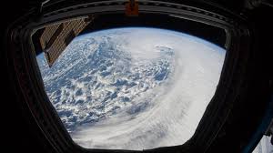
I recently came across these pics,
There are more like them. I was like WTF!
I thought it was not possible to capture the entire Earth in one shot from lower Earth orbit. NASA said this themselves, it was the reason why almost all of their Earth pics are not real, but photoshopped composite images. This is by their own admission.
My role is to make imagery from Earth sciences data. I turn data into pictures.
The last time anyone took a photograph from above low Earth orbit that showed an entire hemisphere (one side of a globe) was in 1972 during Apollo 17. NASA’s Earth Observing System (EOS) satellites were designed to give a check-up of Earth’s health. By 2002, we finally had enough data to make a snap shot of the entire Earth. So we did. The hard part was creating a flat map of the Earth’s surface with four months’ of satellite data. Reto Stockli, now at the Swiss Federal Office of Meteorology and Climatology, did much of this work. Then we wrapped the flat map around a ball. My part was integrating the surface, clouds, and oceans to match people’s expectations of how Earth looks from space. That ball became the famous Blue Marble.
www.nasa.gov...
Images of the earth may seem commonplace, but there are actually very few pictures of the entire planet. The problem, Simmon said, is all the NASA earth-observing satellites are in low-earth or geostationary orbit, meaning none of them are far enough away to see a full hemisphere. The most familiar pictures of the entire Earth are from the 1960s and 1970s Apollo missions to the moon.
This alone should be enough to prove that these cupola pics showing the entire Earth are fake as hell. The funny thing is that if I were to make a thread just showing these pics and would talk about how cool they are and how pretty the Earth looks from ISS there would be all sorts of space buffs, astrophotographers and space exploration "experts" agreeing on this, and not one would even notice the blatant impossibility of such a shot.
Just goes to show they will believe anything that is produced by official sources without any form of critical and independant thought......
Even after all the proof I will have provided by the end of this thread they will still be in denial of the facts and will probably resort to insults and ridicule.
Well the joke's on you.
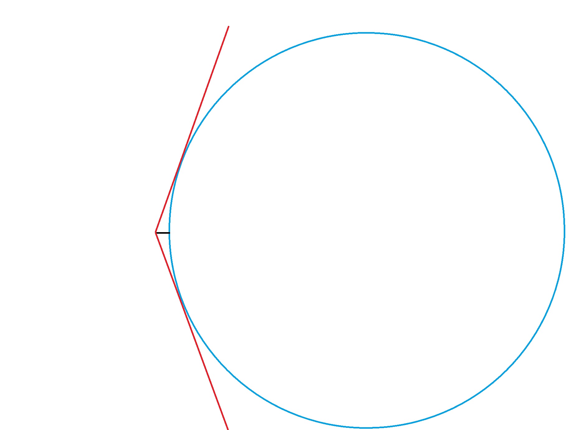
So, although enough proof has already been offered, let me show you some visual proof. Here is a quick scale model of the Earth, showing the max altitude of the ISS above Earth and the max field of view of the Earth, from that altitude.
The ISS maintains an orbit with an altitude of between 330 and 435 km
en.wikipedia.org...
The altitude in my drawing actually represents 450 km.
We can clearly see that it is simply physically impossible to view the entire Earth from this altitude........
We can also do some calculations.
The diameter of the cupola windows together is 2 meter.
The middle window is 80 cm across. Going by these dimensions we can determine that the camera is about 2m from the windows in these pics.
Using Pythagoras we can calculate the angle of the max field of view. This would be an angle of about 53 degrees.
According to Metabunk's Earth Curve Calculator, the distance to the horizon from 450 km is 2625271 meter.
www.metabunk.org...
So using Pythagoras again we can calculate the amount of the Earth that would be visible from 450 km with that field of view.
This would be 4698890 meter, or 4699 km.
In order to get the entire Earth this would have to be 12,742 km........
So there you have it.
100% fake pic of Earth from ISS, produced by NASA.
If anyone has a problem with the values I used for my calculations go ahead and do your own calculation, it will never add up with this view, but I already proved that without the calculations.
Yeah well Trump has-- wait wth? This isn't a political thread!!
Very well presented and thank you for the breath of fresh air; it is very much needed!
edit on 3/25/2017 by ManufacturedDissent because: The thumb was down, unacceptable.
As I understand it the OP's argument is that there should not be a horizon in the fisheye images
showing both space and planet because the space station is so low?
However the Blender rendered post illustrated that this was possible with fish eye lens.
Is my understanding correct ?
Limbo
showing both space and planet because the space station is so low?
However the Blender rendered post illustrated that this was possible with fish eye lens.
Is my understanding correct ?
Limbo
originally posted by: Limbo
As I understand it the OP's argument is that there should not be a horizon in the fisheye images
showing both space and planet because the space station is so low?
However the Blender rendered post illustrated that this was possible with fish eye lens.
Is my understanding correct ?
Limbo
Blender demonstrates the possibility, yes.
originally posted by: TarzanBeta
originally posted by: Limbo
As I understand it the OP's argument is that there should not be a horizon in the fisheye images
showing both space and planet because the space station is so low?
However the Blender rendered post illustrated that this was possible with fish eye lens.
Is my understanding correct ?
Limbo
Blender demonstrates the possibility, yes.
Great!!
So what about the other argument that the image shown is the full hemisphere of the planet?
Limbo
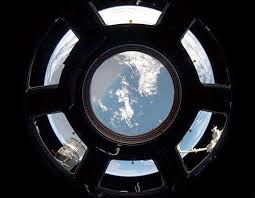
It looks like a composite of six different pictures taken out of the same window. There's a little "mark" in the middle of each window that is the
same.
edit on 25-3-2017 by underwerks because: (no reason given)
a reply to: WaxingGibbons
I just saw the movie life. I'm pretty sure it's a still image from the movie. Exactly shows the window used in the movie. Terrible btw don't bother.
A cast f script
I just saw the movie life. I'm pretty sure it's a still image from the movie. Exactly shows the window used in the movie. Terrible btw don't bother.
A cast f script
edit on 25-3-2017 by Crumbles because: (no reason given)
Forgive me if Ive missed this but clear this up for me, OP.
Does NASA actually say that those pics in the OP are of entire hemispheres?
Does NASA actually say that those pics in the OP are of entire hemispheres?
originally posted by: Limbo
originally posted by: TarzanBeta
originally posted by: Limbo
As I understand it the OP's argument is that there should not be a horizon in the fisheye images
showing both space and planet because the space station is so low?
However the Blender rendered post illustrated that this was possible with fish eye lens.
Is my understanding correct ?
Limbo
Blender demonstrates the possibility, yes.
Great!!
So what about the other argument that the image shown is the full hemisphere of the planet?
Limbo
The argument that it's a full image of the sphere of the planet is possible, but that argument does not equate to the image being a realistic image of the sphere. Lenses compress, reflect, refract, and distort information. By the way, so do human eyes. Our brains have the best hardware and software image correction to date, though. Any argument that claims those images are realistically how the earth looks with human eyes would be a lie. But even NASA, as the OP mentions, basically agrees to the same... Because no one is claiming those pictures are an absolute reproduction of the image of earth through human eyes. It's simply artistic license. Is that right? I don't know. I've often wondered if it's right to give the audience the benefit of the doubt. But every time I doubt that, a few good comedians remind me that the average human has the capacity for abstract thought; not because of the comedian, but because of the comedian's mass appeal.
And I saw the angled windows distorting......big as Dallas
MRX top of the page...read em and weep my brothers and sisters.....
A whole thread could be.....on the effect of the cupola perimeter windows.....I'm too busy right now yezz but....
MRX top of the page...read em and weep my brothers and sisters.....
A whole thread could be.....on the effect of the cupola perimeter windows.....I'm too busy right now yezz but....
edit on 25-3-2017 by GBP/JPY
because: (no reason given)
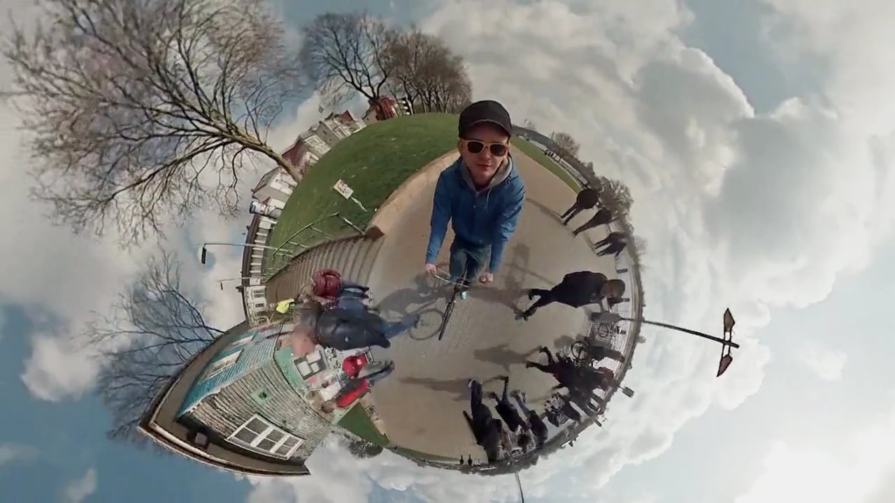
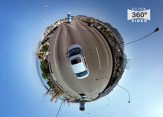
This is the effect you see in those pictures, these pictures are the explanation, plain and simple:
originally posted by: ParanormalGuy
This is the effect you see in those pictures, these pictures are the explanation, plain and simple:
Yes, those images are a very extreme example. I neglected to mention the previous poster who posted a 360 image because it seemed the OP wasn't willing to entertain the hyperbole for what it is.
a reply to: WaxingGibbons
I've seen no convincing arguments that would lead me to believe that those images are "impossible" or even composite.
In this interview with a cupola photographer, he talks about using wide angle lenses and there are a few pictures show that clearly show space around the Earth. In one picture you can see that if you got just a little closer to the window, bamn, there is your "impossible" shot.
www.diyphotography.net...
Is it a perfect 1:1 ratio image of the Earth? No. Does that mean it's fake? No.
While it is true that light travels in a straight line, it can be bent and manipulated by lenses... They pretty much had this technology in the bag as early in Victorian times, over 120+ years ago. So I find it paradoxical that in the age of atomic weapons, computers, rockets, and lasers... People can't comprehend that a centuries old technology can easily handle this kind of shot. I mean, seriously, this is the kind of thing you learn about in Elementary School.
drive.google.com...
Forgive the crudeness of the above drawing, but it's only there to illustrate the physics involved. As you can see from the drawing, light enters all 7 windows from different angles. Since the wide angle lens is like a big dome, light hits all parts of the dome and results in the images that WaxingGibbons originally posted. I'm not sure I can break it down any simpler than that. If someone can prove me wrong, please do.
new topics
-
Electrical tricks for saving money
Education and Media: 34 minutes ago -
VP's Secret Service agent brawls with other agents at Andrews
Mainstream News: 1 hours ago -
Sunak spinning the sickness figures
Other Current Events: 2 hours ago -
Nearly 70% Of Americans Want Talks To End War In Ukraine
Political Issues: 2 hours ago -
Late Night with the Devil - a really good unusual modern horror film.
Movies: 4 hours ago -
Cats Used as Live Bait to Train Ferocious Pitbulls in Illegal NYC Dogfighting
Social Issues and Civil Unrest: 5 hours ago -
The Good News According to Jesus - Episode 1
Religion, Faith, And Theology: 7 hours ago -
HORRIBLE !! Russian Soldier Drinking Own Urine To Survive In Battle
World War Three: 9 hours ago
top topics
-
SETI chief says US has no evidence for alien technology. 'And we never have'
Aliens and UFOs: 16 hours ago, 8 flags -
Cats Used as Live Bait to Train Ferocious Pitbulls in Illegal NYC Dogfighting
Social Issues and Civil Unrest: 5 hours ago, 8 flags -
Florida man's trip overseas ends in shock over $143,000 T-Mobile phone bill
Social Issues and Civil Unrest: 12 hours ago, 8 flags -
VP's Secret Service agent brawls with other agents at Andrews
Mainstream News: 1 hours ago, 6 flags -
Former Labour minister Frank Field dies aged 81
People: 15 hours ago, 4 flags -
Bobiverse
Fantasy & Science Fiction: 12 hours ago, 3 flags -
HORRIBLE !! Russian Soldier Drinking Own Urine To Survive In Battle
World War Three: 9 hours ago, 3 flags -
Nearly 70% Of Americans Want Talks To End War In Ukraine
Political Issues: 2 hours ago, 3 flags -
Sunak spinning the sickness figures
Other Current Events: 2 hours ago, 3 flags -
Late Night with the Devil - a really good unusual modern horror film.
Movies: 4 hours ago, 2 flags
active topics
-
Huge ancient city found in the Amazon.
Ancient & Lost Civilizations • 61 • : Therealbeverage -
The Reality of the Laser
Military Projects • 43 • : 5thHead -
VP's Secret Service agent brawls with other agents at Andrews
Mainstream News • 16 • : matafuchs -
Should Biden Replace Harris With AOC On the 2024 Democrat Ticket?
2024 Elections • 49 • : Therealbeverage -
WF Killer Patents & Secret Science Vol. 1 | Free Energy & Anti-Gravity Cover-Ups
General Conspiracies • 32 • : Arbitrageur -
Is there a hole at the North Pole?
ATS Skunk Works • 38 • : Therealbeverage -
Cats Used as Live Bait to Train Ferocious Pitbulls in Illegal NYC Dogfighting
Social Issues and Civil Unrest • 11 • : charlyv -
SETI chief says US has no evidence for alien technology. 'And we never have'
Aliens and UFOs • 41 • : TheMisguidedAngel -
Naked Eye Supernova Erupting in the T Coronae Borealis
Space Exploration • 13 • : Therealbeverage -
The Real Reason Behind the Sean Combes Exposure
Political Conspiracies • 45 • : ThatSmellsStrange