It looks like you're using an Ad Blocker.
Please white-list or disable AboveTopSecret.com in your ad-blocking tool.
Thank you.
Some features of ATS will be disabled while you continue to use an ad-blocker.

TeleDat Underground Data Transfer and Storage Facility
page: 18
share:
originally posted by: gariac
I noticed an odd paved path just north east of KTPH (civilian Tonopah airport). It was added between image sets. Probably nothing, but I recall some UAV testing going on at KTPH. At least the notam was at KTPH.
This should be obvious, but the bottom of the photo is the north edge of KTPH. The oval is the world famous Tonopah Speedway. The strip is at the top of the photo with a Google Earth marker on it.
coords 38.078013° -117.073000°
Length about 1900ft. It has no aviation markings, but maybe for testing that isn't an issue.
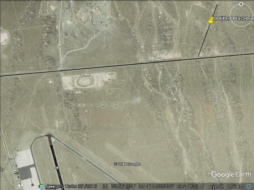
I was going to hijack a previous thread with this, but thought maybe it is worthy of a new one.
Note what looks like a gravel pit to the west of this paved road. 38.077950°, -117.087797°
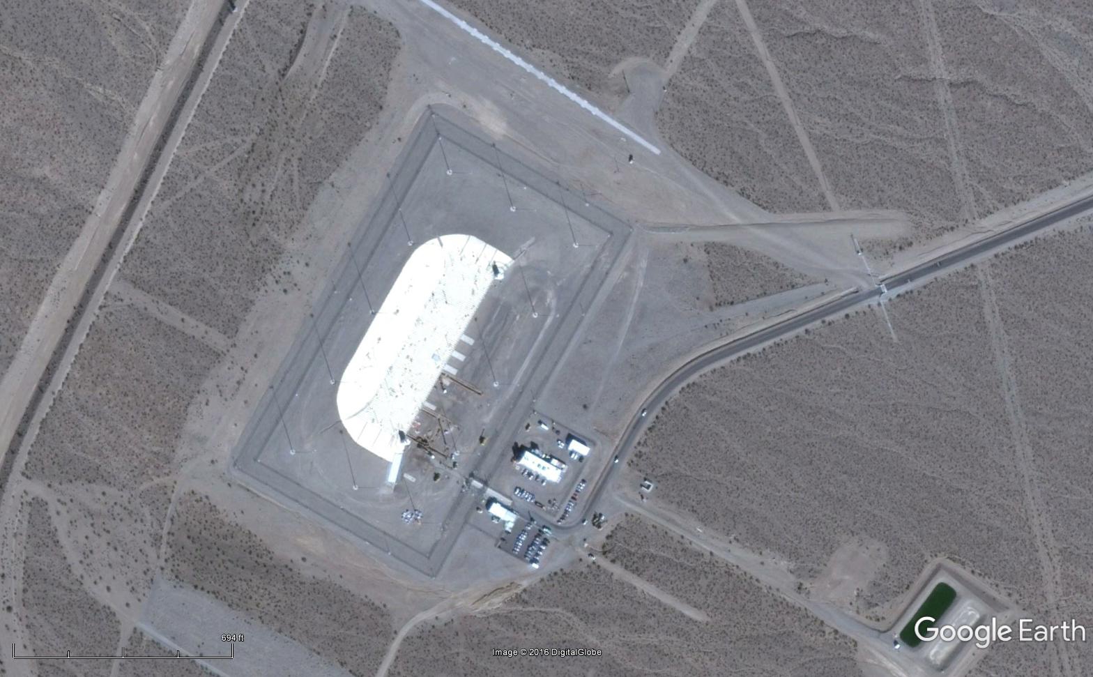
Smack in the middle of it are two Panoramio pictures titled "US Telemetry Data (TeleDat) - Underground Data Transfer and Storage Facility"
A quick Google search had almost no results, other than references to this picture(s).
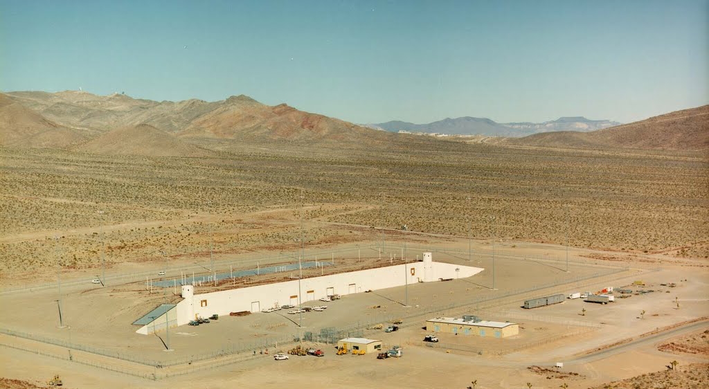
Anyone have more info? I am not sure what an "Underground Data Transfer and Storage Facility" might be!
a reply to: FosterVS
Hmmm, forgetting for a moment that it 'looks like' the kind of bunker they keep ordnance in... and also forgetting for a moment the gubment never tells what kind of facility they are hiding actually contains under pain of torture unto death...
...aaand Also forgetting that Tonopah is a nuclear target and that in general, the shape of things take on a symmetrical look (see the Pentagon) to deflect shock and blast from all directions...
I'm going wth my first idea. An ordnance storage bunker. A very special, secret, live missile under development work and storage bunker.
Any accidents will direct the resulting blast out the back and away from personnel in the forward areas in front of that thick concrete wall.
.o2
Miffed Field Station, satellite view of the weapons storage bunker, for comparison only, Homeland Security...
satellite image from Google maps
satellite image from Google maps
a reply to: FosterVS
probably a "Underground Data Transfer and Storage Facility" will basically be a big bit barn, now without knowing the layout of the area it could be by the looks of it be a great place for having another DoD data cluster and given there looks load of space it would be perfect to build a data centre as its probably got loads of feeds in from other military sites.
The wall above ground looks like a blast wall, if you're probably designing and testing all sorts of things that seriously go boom its probably better to make sure that if something does go wrong the explosion is channeled upwards and away from the rest of the base, take a look at a lot of fireworks companies they normally have 2-3 layers of brick walls with a few feet of space and a pretty flimsy in comparison roof so that if things go wrong it all goes skyward if possible.
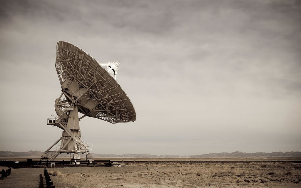
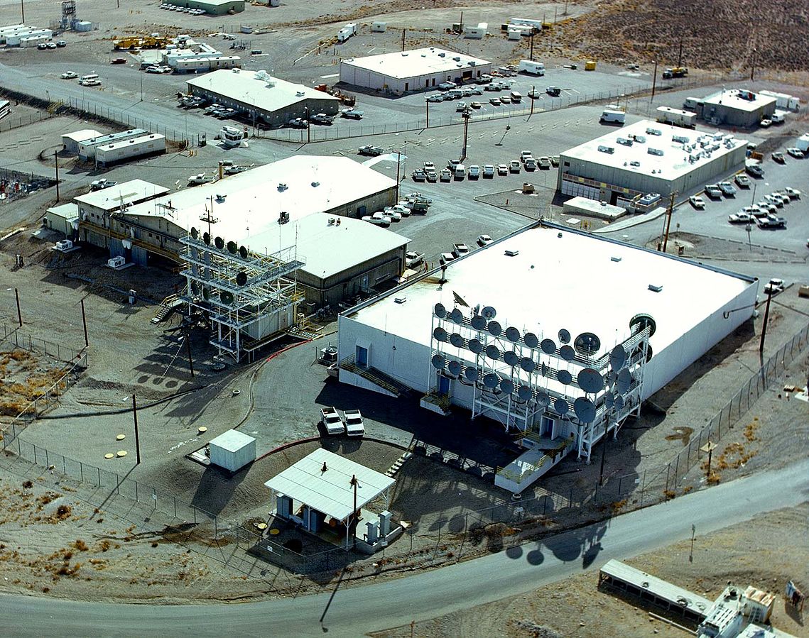
Found another picture. That's a lot of dishes.
I believe it is located at or near the Tonopah airport, not that gravel pit.

And this one:
"US Telemetry Data (TeleDat) - Electromagnetic Radio Distribution Antennae (ERDA) - Tonopah, Nevada"
I believe it is located at or near the Tonopah airport, not that gravel pit.
And this one:
"US Telemetry Data (TeleDat) - Electromagnetic Radio Distribution Antennae (ERDA) - Tonopah, Nevada"
edit on 11-3-2017 by FosterVS because: (no reason given)
a reply to: FosterVS
OK how about this...
I can support FosterVS Google 'data drought' in respect of "US Telemetry Data (TeleDat) - Underground Data Transfer and Storage Facility".
There is a company, however called "U.S. Telemetry Corp." - I took the Overview below from Bloomberg....
Anyway, I'm wondering if this is US Telemetry's "bit barn"?
Given the applications it would need to be a very robust facility - so maybe this was built to a Military spec.?
Equally the applications (eg. utilities monitoring or vehicle location) would also lend themselves to non-terrestrial comms (U.S. Telemetry also holds a licence concerned with wireless data transmission) so maybe this accounts for the array in the photographs?
All the same this isn't identified as a USTC location, and USTC is shown as a small business.
Hope this is of some use.
"Company Overview
U.S. Telemetry Corp designs, develops, constructs, and operates telemetry area networks (TANs) for data telemetry communications that provide status, condition, and event monitoring for potential endpoints.
The networks are designed to carry small-data-packet messages, collect, and sort the information contained in such packets, and make the information available through interfaces such as the Internet.
The primary application for USTC's networks is information services, which include metering and measurement services, alarm-and-alert-status monitoring, and mobile-location telemetry.
The company serves industries including utilities; monitor, measurement, alert, and control; and automated vehicle location, telematics, and mobile location. It is based in Addison, Texas with an additional office in Baton Rouge, Louisiana."
a reply to: FosterVS
They have ground stations that take the data from the ACMI pods, and relay it to where they do the analysis to see what happened during the fights for Red Flag. The air to air is about real time, but the combined stuff takes a little while to analyze.
With TTR, they're taking the data from the test article and relaying it back to the guys running the test in real time. By having the system where it is, they don't have to worry about their LOS being blocked.
originally posted by: FosterVS
originally posted by: gariac
I noticed an odd paved path just north east of KTPH (civilian Tonopah airport). It was added between image sets. Probably nothing, but I recall some UAV testing going on at KTPH. At least the notam was at KTPH.
This should be obvious, but the bottom of the photo is the north edge of KTPH. The oval is the world famous Tonopah Speedway. The strip is at the top of the photo with a Google Earth marker on it.
coords 38.078013° -117.073000°
Length about 1900ft. It has no aviation markings, but maybe for testing that isn't an issue.
I was going to hijack a previous thread with this, but thought maybe it is worthy of a new one.
Note what looks like a gravel pit to the west of this paved road. 38.077950°, -117.087797°
Smack in the middle of it are two Panoramio pictures titled "US Telemetry Data (TeleDat) - Underground Data Transfer and Storage Facility"
A quick Google search had almost no results, other than references to this picture(s).
Anyone have more info? I am not sure what an "Underground Data Transfer and Storage Facility" might be!
Panamino is found under photos on Google Earth.
The US Telemetry Data building is a photograph of the Nevada Test Site Device Assembly Facility (DAF). Pronounced Like Daffy Duck without the fy and the Duck. You hear it on the Groom ATC all the time, and it fact it is a visual point for the Janets. I have no idea what the other cell tower like structure is, but I can tell you last time I was our there, all I saw was the disturbed dirt. They have been doing some sort of earthworks along 6. You see large pipe stored by the highway. It looks like drainage work to me.
Regarding how the dirt was moved in that particular area, you can see ponds for er um well effluent.
Regarding tracking of aircraft for Red Flag, the ACMI (actually renamed to something else) gear is not a dish. You would have a hard time slewing a dish as fast as a low flying aircraft. The ACMI sites use omnidirectional antennas.
Tom Mahood did a nice write up on a newly discovered ACMI site :
ACMI
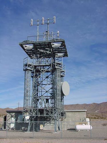
Doing some reverse image searching, I have tracked down the cell tower images, but no actual information. I did some Google "dorking" and can't locate text associated with these links. The "Howard Forum" has some chatter about the image, but nothing useful.
boxcarcabin tower 1
box car cabin tower 2
www.howardforums.com...
edit on 11-3-2017 by gariac because: added Tom Mahood's new website
edit on 12-3-2017 by gariac because: added cell tower
info
edit on 12-3-2017 by gariac because: added howard forum link
originally posted by: FosterVS
Found another picture. That's a lot of dishes.
I believe it is located at or near the Tonopah airport, not that gravel pit.
And this one:
"US Telemetry Data (TeleDat) - Electromagnetic Radio Distribution Antennae (ERDA) - Tonopah, Nevada"
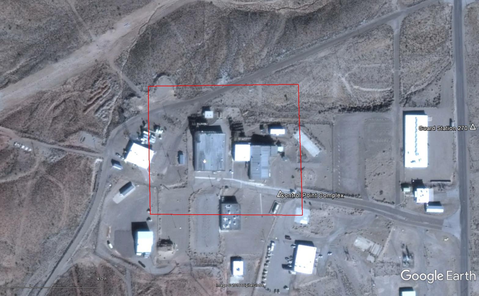
The photo with all the dishes is a place on the NTS.
commons.m.wikimedia.org...:NTS_-_Control_Point.jpg
Since that is a wiki, don't take it as gospel. But I have seen that photo on NTS literature.
Panamino is found under photos on Google Earth.
The US Telemetry Data building is a photograph of the Nevada Test Site Device Assembly Facility (DAF). Pronounced Like Daffy Duck without the fy and the Duck. You hear it on the Groom ATC all the time, and it fact it is a visual point for the Janets. I have no idea what the other cell tower like structure is, but I can tell you last time I was our there, all I saw was the disturbed dirt. They have been doing some sort of earthworks along 6. You see large pipe stored by the highway. It looks like drainage work to me.
Regarding how the dirt was moved in that particular area, you can see ponds for er um well effluent.
Regarding tracking of aircraft for Red Flag, the ACMI (actually renamed to something else) gear is not a dish. You would have a hard time slewing a dish as fast as a low flying aircraft. The ACMI sites use omnidirectional antennas.
Tom Mahood did a nice write up on a newly discovered ACMI site :
ACMI
Doing some reverse image searching, I have tracked down the cell tower images, but no actual information. I did some Google "dorking" and can't locate text associated with these links. The "Howard Forum" has some chatter about the image, but nothing useful.
boxcarcabin tower 1
box car cabin tower 2
www.howardforums.com...
Bah. I knew that looked familiar, I know about that facility and have seen pictures of it before.
I know from experience there is little if any vetting of pictures on Panoramio. You could mark stuff Inapproriate or Misplaced, but Panoramio is closing so it's redundant now.
Some arseholes have nothing better to do than post up
EDITED TO ADD:
The picture with all the dishes is indeed Control Point 6 at the Nevada Test Site
Built in 1951, the Control Point was the principal command and firing control point for the 928 tests which were conducted at the Nevada Test Site.
36.935037, -116.054678
edit on 12-3-2017 by FosterVS because: (no reason given)
new topics
-
Ditching physical money
History: 1 hours ago -
One Flame Throwing Robot Dog for Christmas Please!
Weaponry: 1 hours ago -
Don't take advantage of people just because it seems easy it will backfire
Rant: 2 hours ago -
VirginOfGrand says hello
Introductions: 2 hours ago -
Should Biden Replace Harris With AOC On the 2024 Democrat Ticket?
2024 Elections: 3 hours ago -
University student disciplined after saying veganism is wrong and gender fluidity is stupid
Education and Media: 5 hours ago -
Geddy Lee in Conversation with Alex Lifeson - My Effin’ Life
People: 7 hours ago -
God lived as a Devil Dog.
Short Stories: 7 hours ago -
Police clash with St George’s Day protesters at central London rally
Social Issues and Civil Unrest: 8 hours ago -
TLDR post about ATS and why I love it and hope we all stay together somewhere
General Chit Chat: 9 hours ago
top topics
-
Hate makes for strange bedfellows
US Political Madness: 11 hours ago, 18 flags -
Who guards the guards
US Political Madness: 14 hours ago, 13 flags -
University student disciplined after saying veganism is wrong and gender fluidity is stupid
Education and Media: 5 hours ago, 11 flags -
Police clash with St George’s Day protesters at central London rally
Social Issues and Civil Unrest: 8 hours ago, 8 flags -
TLDR post about ATS and why I love it and hope we all stay together somewhere
General Chit Chat: 9 hours ago, 7 flags -
Should Biden Replace Harris With AOC On the 2024 Democrat Ticket?
2024 Elections: 3 hours ago, 5 flags -
Has Tesla manipulated data logs to cover up auto pilot crash?
Automotive Discussion: 16 hours ago, 3 flags -
One Flame Throwing Robot Dog for Christmas Please!
Weaponry: 1 hours ago, 2 flags -
Don't take advantage of people just because it seems easy it will backfire
Rant: 2 hours ago, 2 flags -
Geddy Lee in Conversation with Alex Lifeson - My Effin’ Life
People: 7 hours ago, 2 flags
active topics
-
VirginOfGrand says hello
Introductions • 1 • : VirginOfGrand -
Candidate TRUMP Now Has Crazy Judge JUAN MERCHAN After Him - The Stormy Daniels Hush-Money Case.
Political Conspiracies • 740 • : matafuchs -
Should Biden Replace Harris With AOC On the 2024 Democrat Ticket?
2024 Elections • 33 • : BernnieJGato -
Gold and silver prices....woo hoo
History • 84 • : annonentity -
The Democrats Take Control the House - Look what happened while you were sleeping
US Political Madness • 108 • : Zanti Misfit -
Ditching physical money
History • 7 • : TheMisguidedAngel -
BREAKING! Another Bridge Hit by a barge #3 this week.
Mainstream News • 110 • : RookQueen2 -
One Flame Throwing Robot Dog for Christmas Please!
Weaponry • 4 • : Dalamax -
15 Unhealthiest Sodas On The Market
Health & Wellness • 40 • : Freeborn -
Remember These Attacks When President Trump 2.0 Retribution-Justice Commences.
2024 Elections • 47 • : Zanti Misfit
8