It looks like you're using an Ad Blocker.
Please white-list or disable AboveTopSecret.com in your ad-blocking tool.
Thank you.
Some features of ATS will be disabled while you continue to use an ad-blocker.

New Google Earth Imagery of Our Favorite Base
page: 16
share:
Date on the imagery is 7/19/2016
I just loaded it up, so far haven't looked at much, some new asphalt ("apron"?) around the "new new" hangar.
I just loaded it up, so far haven't looked at much, some new asphalt ("apron"?) around the "new new" hangar.
edit on 16-2-2017 by FosterVS
because: (no reason given)
Coordinates? Screenshot?
I looked at it the other day, didn't see much.
I looked at it the other day, didn't see much.
a reply to: FosterVS
The pavement sort of looked that way on the previous imagery. In fact I'm not really sure this imagery is new other than the date. ;-)
I did notice there is new imagery along route 93, which is probably not of much interest to most people. I was looking at the Alamo airport, which had 14 and 32 markings just like the base. But that can be due to similar prevailing winds. As far as I know, the new Alamo runway is financed by the country.
a reply to: FosterVS
"hey lets make a thread about new photos and not put any of them in it! makes total sense!"
-op probly...
new2.fjcdn.com...
"hey lets make a thread about new photos and not put any of them in it! makes total sense!"
-op probly...
new2.fjcdn.com...
originally posted by: NobodiesNormal
a reply to: FosterVS
"hey lets make a thread about new photos and not put any of them in it! makes total sense!"
-op probly...
new2.fjcdn.com...
Google Earth is free. I highly recommend it. Then you don't have to rely on others for photo's.
originally posted by: gariac
a reply to: FosterVS
The pavement sort of looked that way on the previous imagery. In fact I'm not really sure this imagery is new other than the date. ;-)
I notice the imagery for the TTR has the same date. GE history shows mid-2007 as the previous image date.
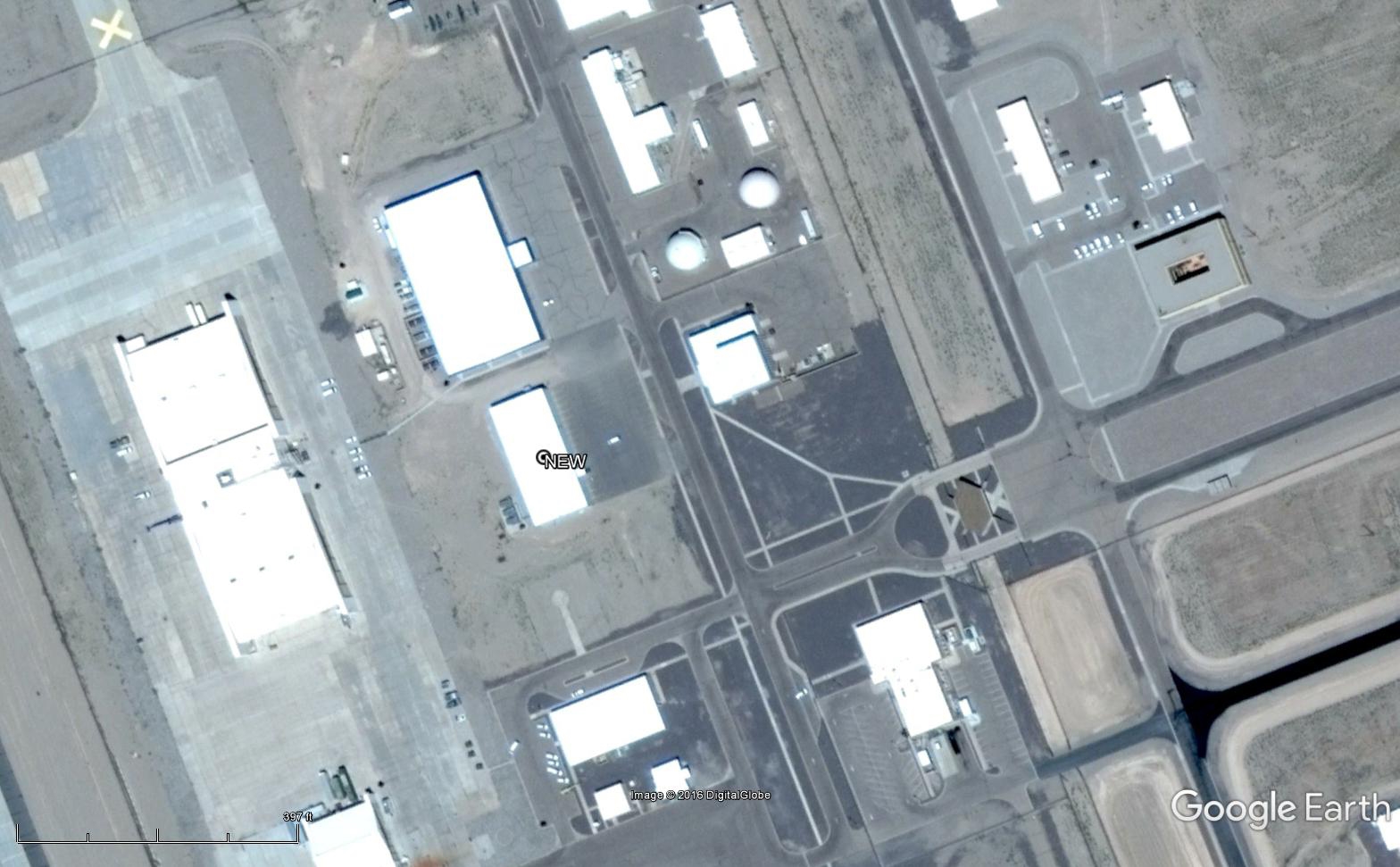
One main difference I see is a new building here:
37.790270°, -116.768657°
Janet parking lot is packed, but that could be because it was a weekday.
The angle of the imagery also shows what I interpret as a lot of activity at some of the hangars, judging by marks on the concrete. i.e.
edit on 18-2-2017 by FosterVS because: (no reason given)
a reply to: FosterVS
I'm relatively sure that new building has been discussed here before. It is windowless, but not really shaped like a warehouse, plus it lacks roll up doors. Offices would have windows.
You can tell what it isn't, but it is hard to tell what that building is used for.
If I haven't mentioned it, the domed buildings contain flight simulators.
I have a few photos I've pulled off of the Sandia newsletter about the TTR that I never get around to uploading. The remodeled the Sandia complex tower. Now it looks at least 00's era versus 70's inside.
www.lazygranch.com...
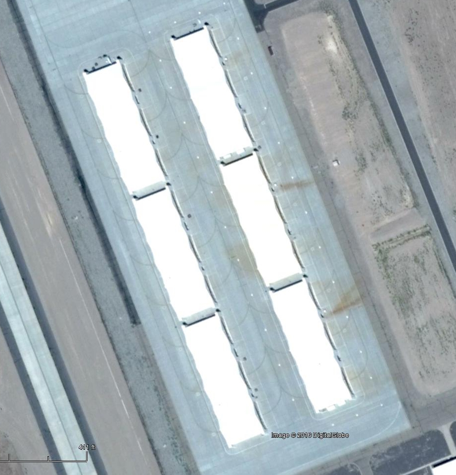
Speaking of the "barns", using some video released by the USAF and other sources, I created this hangar map. The white hangars were operation test (OT), which might explain why they house the current fleet.
I could probably come up with the names of the ramps if I worked at it. You can watch the planes taxi and listen to the tower to figure out what is what.
I'm relatively sure that new building has been discussed here before. It is windowless, but not really shaped like a warehouse, plus it lacks roll up doors. Offices would have windows.
You can tell what it isn't, but it is hard to tell what that building is used for.
If I haven't mentioned it, the domed buildings contain flight simulators.
I have a few photos I've pulled off of the Sandia newsletter about the TTR that I never get around to uploading. The remodeled the Sandia complex tower. Now it looks at least 00's era versus 70's inside.
www.lazygranch.com...
Speaking of the "barns", using some video released by the USAF and other sources, I created this hangar map. The white hangars were operation test (OT), which might explain why they house the current fleet.
I could probably come up with the names of the ramps if I worked at it. You can watch the planes taxi and listen to the tower to figure out what is what.
edit on 18-2-2017 by gariac because: added map
I noticed an odd paved path just north east of KTPH (civilian Tonopah airport). It was added between image sets. Probably nothing, but I recall some
UAV testing going on at KTPH. At least the notam was at KTPH.
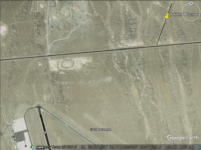
This should be obvious, but the bottom of the photo is the north edge of KTPH. The oval is the world famous Tonopah Speedway. The strip is at the top of the photo with a Google Earth marker on it.
coords 38.078013° -117.073000°
Length about 1900ft. It has no aviation markings, but maybe for testing that isn't an issue.
originally posted by: zipper104
a reply to: gariac
It is the road to Tonopah Shooting Range.
Thanks. I checked it out once. Just a few chairs as "infrastructure." Supposedly it dates backs to the Army days. At one time there was a Google Earth "community" marker there, which is how I learned about the range.
The "community" marker indicating KTPH is the TTR is still there. ;-)
originally posted by: FosterVS
originally posted by: gariac
I noticed Bald Mountain has new imagery.
I thought something was different, then realized it was just the angle the imagery was taken at.
Also, they missed the GLR guard shack by about 1500 ft. Darn.
Looking at that the area of the concrete pad just east of Bald Mountain using the history feature, there was just a road there at one time. Years ago we tried to box the camo dudes on the road by having someone hide on that road. Unfortunately the dudes must have noticed we were short one person and didn't fall for the trick. But this makes me wonder if that pad is in the forbidden zone.
I advise anyone investigating to first find the border poles rather than just head up to the pad. Those poles are far apart, making it hard to tell if you are crossing the border by accident. The best rule is not to just spot two poles, but rather three poles since you can be fooled when the border makes a 90 degree turn.
Those pads thus far seem to be a stalled project.
edit on 11-3-2017 by gariac because: grammar
originally posted by: FosterVS
originally posted by: NobodiesNormal
a reply to: FosterVS
"hey lets make a thread about new photos and not put any of them in it! makes total sense!"
-op probly...
new2.fjcdn.com...
Google Earth is free. I highly recommend it. Then you don't have to rely on others for photo's.
what you mean is, then i dont have to rely on thread authors to include actual content in their threads. right? ya great move there guy. good luck with that idea...
Odd pattern at the Tonopah Test Range. Perhaps the space aliens landed there and left the shape of their space craft.
www.lazygranch.com...
www.lazygranch.com...
new topics
-
The functionality of boldening and italics is clunky and no post char limit warning?
ATS Freshman's Forum: 2 minutes ago -
Meadows, Giuliani Among 11 Indicted in Arizona in Latest 2020 Election Subversion Case
Mainstream News: 37 minutes ago -
Massachusetts Drag Queen Leads Young Kids in Free Palestine Chant
Social Issues and Civil Unrest: 52 minutes ago -
Weinstein's conviction overturned
Mainstream News: 2 hours ago -
Supreme Court Oral Arguments 4.25.2024 - Are PRESIDENTS IMMUNE From Later Being Prosecuted.
Above Politics: 3 hours ago -
Krystalnacht on today's most elite Universities?
Social Issues and Civil Unrest: 3 hours ago -
Chris Christie Wishes Death Upon Trump and Ramaswamy
Politicians & People: 4 hours ago -
University of Texas Instantly Shuts Down Anti Israel Protests
Education and Media: 6 hours ago -
Any one suspicious of fever promotions events, major investor Goldman Sachs card only.
The Gray Area: 8 hours ago
top topics
-
VP's Secret Service agent brawls with other agents at Andrews
Mainstream News: 17 hours ago, 11 flags -
Krystalnacht on today's most elite Universities?
Social Issues and Civil Unrest: 3 hours ago, 7 flags -
Weinstein's conviction overturned
Mainstream News: 2 hours ago, 6 flags -
Supreme Court Oral Arguments 4.25.2024 - Are PRESIDENTS IMMUNE From Later Being Prosecuted.
Above Politics: 3 hours ago, 5 flags -
Electrical tricks for saving money
Education and Media: 16 hours ago, 5 flags -
University of Texas Instantly Shuts Down Anti Israel Protests
Education and Media: 6 hours ago, 3 flags -
Any one suspicious of fever promotions events, major investor Goldman Sachs card only.
The Gray Area: 8 hours ago, 2 flags -
Meadows, Giuliani Among 11 Indicted in Arizona in Latest 2020 Election Subversion Case
Mainstream News: 37 minutes ago, 2 flags -
Massachusetts Drag Queen Leads Young Kids in Free Palestine Chant
Social Issues and Civil Unrest: 52 minutes ago, 2 flags -
God's Righteousness is Greater than Our Wrath
Religion, Faith, And Theology: 13 hours ago, 1 flags
active topics
-
Biden--My Uncle Was Eaten By Cannibals
US Political Madness • 74 • : xuenchen -
University of Texas Instantly Shuts Down Anti Israel Protests
Education and Media • 144 • : CriticalStinker -
Weinstein's conviction overturned
Mainstream News • 17 • : 5thHead -
VP's Secret Service agent brawls with other agents at Andrews
Mainstream News • 52 • : WeMustCare -
The functionality of boldening and italics is clunky and no post char limit warning?
ATS Freshman's Forum • 0 • : JonnyC555 -
HORRIBLE !! Russian Soldier Drinking Own Urine To Survive In Battle
World War Three • 43 • : confuzedcitizen -
Chris Christie Wishes Death Upon Trump and Ramaswamy
Politicians & People • 15 • : diaclonethunder -
Massachusetts Drag Queen Leads Young Kids in Free Palestine Chant
Social Issues and Civil Unrest • 5 • : Texastruth2 -
Candidate TRUMP Now Has Crazy Judge JUAN MERCHAN After Him - The Stormy Daniels Hush-Money Case.
Political Conspiracies • 759 • : xuenchen -
New whistleblower Jason Sands speaks on Twitter Spaces last night.
Aliens and UFOs • 60 • : baablacksheep1
6