It looks like you're using an Ad Blocker.
Please white-list or disable AboveTopSecret.com in your ad-blocking tool.
Thank you.
Some features of ATS will be disabled while you continue to use an ad-blocker.

BREAKING: Fearing collapse of emergency spillway at Oroville Dam, Oroville evacuated
page: 15share:
originally posted by: Reverbs
Anoter reason I want people to focus on the wider area.
It's ALL connected.
That's exactly what I was thinking, too. It's hard to imagine all this connected, but it is. The storm series hit all of California, the northern half has the dam systems that generate electricity and provide for a water storage and delivery system, the waterways (natural and man made) are connected, and the area in the wide valley is flat, giving swollen waterways plenty of area to spread out. Waters entering into dams like Oroville flow in fast from their mountainous watersheds.
Oroville Dam's problems were indeed not with the dam itself but with the concrete main spillway and then the emergency overflow. Oroville highlights what could be future problems.
Most of the nation’s 84,000 dams were built between 1950 and 1980 and were not designed for the populations now surrounding them, or for today’s changing climate.
....
The dam was built in the 1960s when temperatures were cooler and more precipitation was stored in a greater snowpack in the mountains of the Feather River watershed, which drains into Lake Oroville. Today warming temperatures are bringing more rain as well as melting the Sierra Nevada snowpack earlier in the spring. As the counties’ attorneys predicted, among the results is a rush of downhill water much faster than in the past. “We anticipated that this crisis might come about,” says Tony Rossmann, special counsel to Butte County.
...
The hydrologic models DWR [California Department of Water Resources] used are based on the colder decades of the 1940s and 1950s—“a hypothetical future that DWR knows to be dangerously false,” the counties responded. Ironically, the counties based their challenge on climate change science developed by DWR’s own scientists, Rossmann says: “They’re among the world’s experts.” He called DWR’s “stubborn refusal to consider 21st century science” particularly surprising for a state agency where the governor repeatedly touts preparedness for climate change.
Scientific American article
This BTW is not a matter of "red dams" and "blue dams". One blog post last week questioned why a "blue dam" got $ for work but a "red dam" didn't.... the dam that got money for upgrades was a federal dam (older BTW), Oroville is a state dam! Different sources of money.
A wiki showing List of dams and reservoirs in California. Private, county, district, state, different types of federal ownership even. The town of Oroville dodged a bullet this year; now will be the hard, costly work of rebuilding damaged infrastructure to meet a changing climate. The odd thing is, we may even again have years of drought followed by heavy rain; we just have to be better prepared next time.
a lot of money is made off of disasters...maybe an index fund or an ETF for climate change related company stocks
a reply to: LadyGreenEyes
You had direct experience with evacuating for rising waters, and with a baby! I know what you mean about not being comfortable with these situations.
When the last big flood year hit 20 years ago, I was standing at a second story window of the house I lived in at the time, watching the river a quarter mile away overflow its banks. (lol What I call a river out here is what is labeled a creek in most other states.) That water had come from damn releases mixed in with heavy rain. Well, lo and behold, the next year a developer came in and put up a tract of homes there! Sure enough, some of the streets had to use sandbags the year after that.
The delta area of CA has levees, and a road we used to use as a shortcut home thirty years ago went through what was at the time a sparsely populated area. About 13 years ago we had occasion to drive the same road, only now there were tracts of homes right next to levees! Even though it looks silly at first, some people in the delta have built there homes atop a man made hill, flat land around it. And some houses are built with living areas above a first level, like what are built along ocean frontages, with the lower level capable of surviving being flooded with no or minimal damage.
Yeah, I think people forget that the New Orleans Katrina damage was not from the hurricane itself but from levee/wall failure. We're sometimes at the mercy of nature with our infrastructure. It's like any technology, when it works it's great, when it doesn't it's not so great.
edit on
21-2-2017 by desert because: grammar
a reply to: desert
I honestly stopped watching at this point. And there will be no more press conferences.
but for everyone else. This guy has been trustworthy the entire time. Well I found out about him on the 19th.
He flew his plane over a few days before that and had such good knowledge, that the news media gave him a press pass.
So now he's been on site.
See how high the water got after those 'monster' storms?
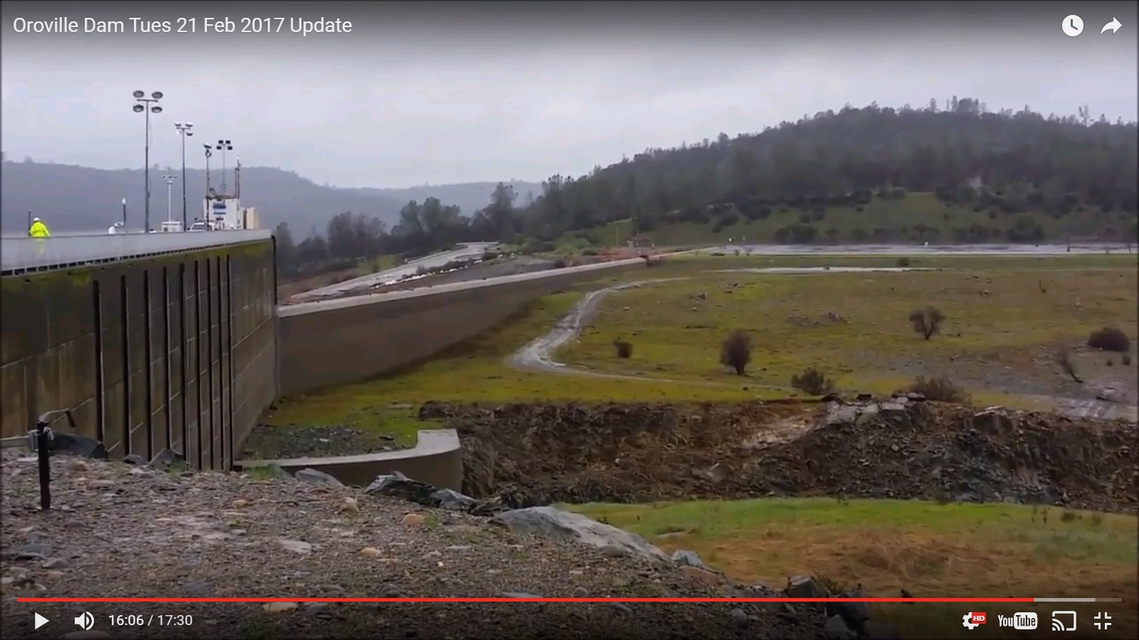
files.abovetopsecret.com...
So it rose about 3 feet.. So they will shut the water off very soon 2 days 3 days? somewhere in there I think. And that's when you guys can learn more about the damage to the main spillway and rock and dirt underneath the main spillway.
I honestly stopped watching at this point. And there will be no more press conferences.
but for everyone else. This guy has been trustworthy the entire time. Well I found out about him on the 19th.
He flew his plane over a few days before that and had such good knowledge, that the news media gave him a press pass.
So now he's been on site.
See how high the water got after those 'monster' storms?
files.abovetopsecret.com...
So it rose about 3 feet.. So they will shut the water off very soon 2 days 3 days? somewhere in there I think. And that's when you guys can learn more about the damage to the main spillway and rock and dirt underneath the main spillway.
edit on 21-2-2017 by Reverbs because: (no reason
given)
a reply to: Reverbs
Thanks for excellent video. (love his intro music) Hopefully, Spring and Summer releases and storage can be done without worry. Yeah, lots of work to be done for the main spillway. I wish the reason for the initial damage will be found, but maybe it never will be pinpointed, if any evidence washed away. Also, debris, re-start power plant, facing the emergency spillway.... lots of work to be done. $$$
Upstream, downstream... all connected. If increased precipitation is in the far weather future, that's better than the drought, but we'll have to be prepared next time.
End of Oroville story for now.
Doesn't look good next week. a good chunk of the countries agriculture south here the dam. a lot of mountain snow to melt soon
a reply to: Corruptedstructure
Yep, lots of water this year. Here's one way to use it, to replenish the underground aquifer.
How California farmers are using floods to feed soil
If the new normal will be periods of drought followed by deluges, then the new normal will have to be putting the extra water back into the ground. Otherwise, farmers and homes with wells will have either dry wells or pay much higher costs to pump water up from further down.
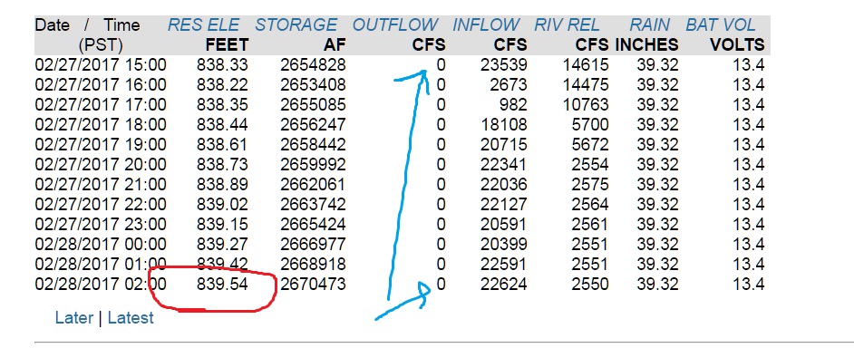
Since I said I'd keep it updated the main spillway has been cut off for at least 12 hours.
the lake level is below 840 so now they have 60 feet to work with.
the inflow is around 20,000 cfs, so the lake level is rising.
So now they get to try to get the power plant running. There is no rain in the forecast.
larger version
the lake level is below 840 so now they have 60 feet to work with.
the inflow is around 20,000 cfs, so the lake level is rising.
So now they get to try to get the power plant running. There is no rain in the forecast.
larger version
edit on 28-2-2017 by Reverbs because: (no reason
given)
a reply to: Reverbs
I have seen recent footage, showing all sorts of damage. I know how spillways work, too. Just because people disagree on whether or not the danger has passed does not mean they don't have all of the information.
The spillway was designed for a certain flow, too, and it failed at around 1/10 of that amount.
Still waiting, by the way, on your pics of the dam itself.
originally posted by: desert
a reply to: LadyGreenEyes
You had direct experience with evacuating for rising waters, and with a baby! I know what you mean about not being comfortable with these situations.
When the last big flood year hit 20 years ago, I was standing at a second story window of the house I lived in at the time, watching the river a quarter mile away overflow its banks. (lol What I call a river out here is what is labeled a creek in most other states.) That water had come from damn releases mixed in with heavy rain. Well, lo and behold, the next year a developer came in and put up a tract of homes there! Sure enough, some of the streets had to use sandbags the year after that.
That sounds so similar to what we saw after that flooding!! Some areas, that were underwater almost completely, they actually built apartment buildings, right by the river bank! Utter insanity, and you can bet no one renting was told about the danger.
The delta area of CA has levees, and a road we used to use as a shortcut home thirty years ago went through what was at the time a sparsely populated area. About 13 years ago we had occasion to drive the same road, only now there were tracts of homes right next to levees! Even though it looks silly at first, some people in the delta have built there homes atop a man made hill, flat land around it. And some houses are built with living areas above a first level, like what are built along ocean frontages, with the lower level capable of surviving being flooded with no or minimal damage.
Wow, I can't imagine building on the flood side of a levee like that!! How did they ever get approval??
Yeah, I think people forget that the New Orleans Katrina damage was not from the hurricane itself but from levee/wall failure. We're sometimes at the mercy of nature with our infrastructure. It's like any technology, when it works it's great, when it doesn't it's not so great.
I can see some areas, suh as beachfront, being built to handle flooding from a storm, but some places, it just makes no sense!! One catastrophe, and a lot more people are in danger. New Orleans, they had issues from building below sea level, pretending nothing would ever happen, and compounded those by most people being totally unprepared.
a reply to: LadyGreenEyes
Here are some photos of the Spillway. Amazing power, lots of work ahead.
Link
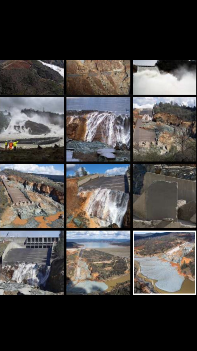
Here are some photos of the Spillway. Amazing power, lots of work ahead.
Link
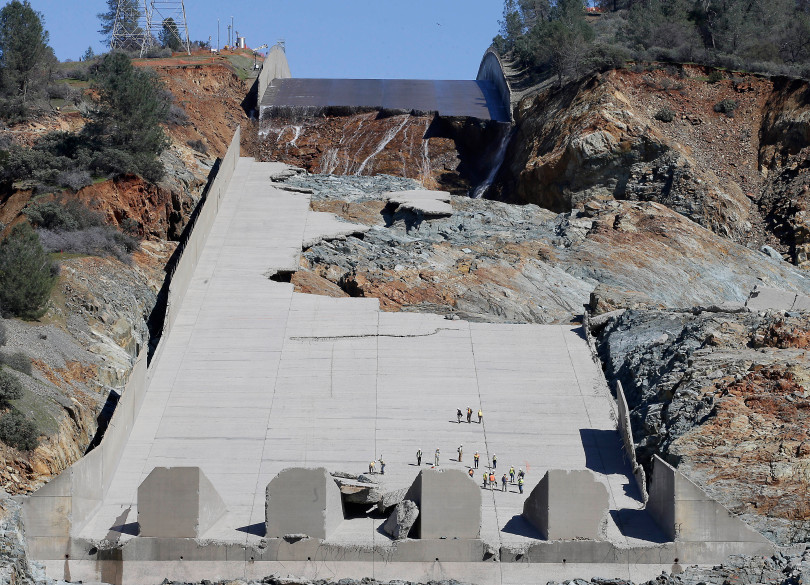
Wanted to add another pix of the main spillway, one that shows, with people in it, just how big it is and the enormity of the damage.
a reply to: desert
"They all look like little ants" (Bugs life quote)
Thanks for posting that, my phone was freaking out when I posted above. I couldn't get individual pics from the link to post.
Has there been any confirmation (official story) about what caused the spill way to break apart?
"They all look like little ants" (Bugs life quote)
Thanks for posting that, my phone was freaking out when I posted above. I couldn't get individual pics from the link to post.
Has there been any confirmation (official story) about what caused the spill way to break apart?
a reply to: Observationalist
The pix you posted gave a great overview of the Oroville story. It showed the cascade of events: the main spillway damage, the emergency spillway overflow and resulting damage, the buildup of water and debris in the pool at the base. All it took was all the rain we got to set things in motion.
As for any major catastrophic event, the investigation of this one will take the usual lengthy time to investigate and write up the report. Here is an article I found that is a good read; it deals with the breakup of the main spillway, which led to everything else happening.
Oroville Dam: What made the spillway collapse?
It could be we saw water work in both small (cavitation) and large (erosion) ways for this event. Add in any possible human negligence and disasters find a way to happen. Extremely costly disasters. A few months from now, I'll probably search to see if any report is out, if I don't catch it on any news.
Found this article this morning and thought I would just drop it here for anyone interested.
www.dailymail.co.uk...
www.dailymail.co.uk...
a reply to: Observationalist
Yeah, have seen video, too, of the massive amounts of water still going through the breaks, and the heights gained by the mists are wild. Much damage, and still a very real problem!
Yeah, have seen video, too, of the massive amounts of water still going through the breaks, and the heights gained by the mists are wild. Much damage, and still a very real problem!
Been meaning to get back here. Yes, the damaged spillway had to be used again.
From March 11
With snow melting, Oroville managers plan to use mangled spillway
but it is shutting down again...
Oroville Dam spillway releases to be halted
With anymore Spring rains and Summer snow melt, it's going to be interesting to see how they manage dam releases and main spillway repair. What a job to repair that spillway! The thought of a "very significant risk" for Fall is a scary thought, one I would hate to even think about if I lived up there.
From March 11
With snow melting, Oroville managers plan to use mangled spillway
but it is shutting down again...
Oroville Dam spillway releases to be halted
Safety experts say there is no time for delays in the state plan to restore the critical main spillway at the 770-foot Oroville Dam, and they warn that California would face a "very significant risk" if the spillway is not in working order by fall, the start of the next rainy season.
With anymore Spring rains and Summer snow melt, it's going to be interesting to see how they manage dam releases and main spillway repair. What a job to repair that spillway! The thought of a "very significant risk" for Fall is a scary thought, one I would hate to even think about if I lived up there.
new topics
-
Is the origin for the Eye of Horus the pineal gland?
General Conspiracies: 8 minutes ago -
Man sets himself on fire outside Donald Trump trial
Mainstream News: 19 minutes ago -
Biden says little kids flip him the bird all the time.
2024 Elections: 25 minutes ago -
The Democrats Take Control the House - Look what happened while you were sleeping
US Political Madness: 1 hours ago -
Sheetz facing racial discrimination lawsuit for considering criminal history in hiring
Social Issues and Civil Unrest: 1 hours ago -
In an Historic First, In N Out Burger Permanently Closes a Location
Mainstream News: 3 hours ago -
MH370 Again....
Disaster Conspiracies: 3 hours ago -
Are you ready for the return of Jesus Christ? Have you been cleansed by His blood?
Religion, Faith, And Theology: 5 hours ago -
Chronological time line of open source information
History: 7 hours ago -
A man of the people
Diseases and Pandemics: 8 hours ago
top topics
-
Israeli Missile Strikes in Iran, Explosions in Syria + Iraq
World War Three: 17 hours ago, 18 flags -
In an Historic First, In N Out Burger Permanently Closes a Location
Mainstream News: 3 hours ago, 14 flags -
Thousands Of Young Ukrainian Men Trying To Flee The Country To Avoid Conscription And The War
Other Current Events: 13 hours ago, 7 flags -
The Democrats Take Control the House - Look what happened while you were sleeping
US Political Madness: 1 hours ago, 7 flags -
Iran launches Retalliation Strike 4.18.24
World War Three: 16 hours ago, 6 flags -
12 jurors selected in Trump criminal trial
US Political Madness: 16 hours ago, 4 flags -
4 plans of US elites to defeat Russia
New World Order: 10 hours ago, 4 flags -
A man of the people
Diseases and Pandemics: 8 hours ago, 4 flags -
Sheetz facing racial discrimination lawsuit for considering criminal history in hiring
Social Issues and Civil Unrest: 1 hours ago, 2 flags -
Biden says little kids flip him the bird all the time.
2024 Elections: 25 minutes ago, 2 flags
active topics
-
Israeli Missile Strikes in Iran, Explosions in Syria + Iraq
World War Three • 95 • : DBCowboy -
12 jurors selected in Trump criminal trial
US Political Madness • 64 • : JadedGhost -
Sheetz facing racial discrimination lawsuit for considering criminal history in hiring
Social Issues and Civil Unrest • 5 • : Shoshanna -
Is the origin for the Eye of Horus the pineal gland?
General Conspiracies • 0 • : JoelSnape -
MH370 Again....
Disaster Conspiracies • 7 • : billxam1 -
ChatGPT Beatles songs about covid and masks
Science & Technology • 23 • : ArMaP -
Biden says little kids flip him the bird all the time.
2024 Elections • 2 • : xuenchen -
The Democrats Take Control the House - Look what happened while you were sleeping
US Political Madness • 12 • : ImagoDei -
Man sets himself on fire outside Donald Trump trial
Mainstream News • 0 • : Mantiss2021 -
Are you ready for the return of Jesus Christ? Have you been cleansed by His blood?
Religion, Faith, And Theology • 16 • : FlyersFan