It looks like you're using an Ad Blocker.
Please white-list or disable AboveTopSecret.com in your ad-blocking tool.
Thank you.
Some features of ATS will be disabled while you continue to use an ad-blocker.

Oroville dam within Quarter inch of overflowing over emergency spillway
page: 2share:
Jerry Brown Asks Donald Trump
For California Storm Disaster Declaration
Brown has already declared a state emergency in 49 counties.
Most of the damage has occurred to roads, bridges, dams and water control and filtration systems, according to Brown’s letter, which estimates damages of $162 million for the January storms. Bad weather is continuing to wallop California this month.
On Friday, the state’s second-largest reservoir was at 99 percent capacity and threatening to burst its banks after officials cut down use of the Oroville Dam’s seriously damaged concrete spillway, which is supposed to divert excess water. The eroded spillway continued to deteriorate under a chaotic rush of water that was washing away ground dangerously close to power lines and threatening to flood communities downstream, the Sacramento Bee reported.
originally posted by: Blaine91555
L A Times
Water started flowing down the spillway into the Feather River early Saturday, with officials continuing to emphasize there was no imminent threat to the public or to the integrity of the dam.
"Relatively speaking, it's a small spill," See said, noting that the flow over the emergency spillway is expected to end in the next 38-56 hours.
"The lake will actually drop and the spill will cease," he said.
The dam is not threatened by these conditions,” said Bill Croyle, acting director of the Department of Water Resources. “These kinds of flows are typical for this kind of runoff period.”
That article is from 45 minutes ago at time of posting. Sounds like there is no threat?
Let's hope not, but I don't think that spillway's gonna recover in our lifetimes. Did you see the video above ... www.abovetopsecret.com...? If you didn't, look at it at the 4 minute mark.
edit on 1122017 by Snarl because: Link back to page 1
a reply to: burntheships
I'm in Northern cal. We have about 4 days of dry weather before it rains again. January and February are typically the wettest month with one or two system like we have seen. But this has been a relentless pattern of rain and high winds. Atmospheric rivers they call them.
The scary thing to me is the deep and wet snowpack in the Sierras. I'm sure this pattern will slowdown and we can dry out a bit, but if we get anything similar in late March early April when all that snow melts, look out, That dam will have a bunch of pressure build up.
I read that he hydro power station at the base of the dam may shut down too. Which would stop its flow of water from the dam.
I'm down stream from Lake Oroville quite a ways in Sacramento but still watching as the American River rises, trusting the Folsom Dam is working fine.
Weather like this is common there, happens in cycles.
I'm in Northern cal. We have about 4 days of dry weather before it rains again. January and February are typically the wettest month with one or two system like we have seen. But this has been a relentless pattern of rain and high winds. Atmospheric rivers they call them.
The scary thing to me is the deep and wet snowpack in the Sierras. I'm sure this pattern will slowdown and we can dry out a bit, but if we get anything similar in late March early April when all that snow melts, look out, That dam will have a bunch of pressure build up.
I read that he hydro power station at the base of the dam may shut down too. Which would stop its flow of water from the dam.
I'm down stream from Lake Oroville quite a ways in Sacramento but still watching as the American River rises, trusting the Folsom Dam is working fine.
I'm in Northern Cali too. Hopefully there is bedrock not too far below the spillway and the emergency spillway. That's an awfully big hole. That will
take some time to patch. Oroville is a very large reservoir, and I'd hate to see that dam break. There are levees and rivers all around my city, and
they are pretty full already.
a reply to: Blaine91555
That sounds like response from a government that does not want to alarm anyone that you see in the movies.
Government: "It's all going to be all right." *crosses fingers and prays
That sounds like response from a government that does not want to alarm anyone that you see in the movies.
Government: "It's all going to be all right." *crosses fingers and prays
I lived in that area for 10 years and am quite familiar with Lake Oroville. I think it would help to understand the construction and the one basic
flaw I see in its design:
en.wikipedia.org...
However, note the following in which it is admitted that this, the tallest and second largest dam in California sits directly on a fault line:
ibid
Let's hope this calms down, but I have doubts about the structural integrity of something that has been rattling around for 50 years. If it talked back, the authorities didn't share what it said.
Please also see: www.linkedin.com...
Groundbreaking on the dam site occurred in May 1957 with the relocation of the Western Pacific Railroad tracks that ran through the Feather River canyon. The Burns-Porter Act, which authorized the SWP, was not passed until November 8, 1960 – and only by a slim margin.[10][11] Engineer Donald Thayer of the DWR was commissioned to design and head construction of Oroville Dam, and the primary work contract was awarded to Oro Dam Constructors Inc., a joint venture led by Oman Construction Co.[12] Two concrete-lined diversion tunnels, each 4,400 feet (1,300 m) long and 35 feet (11 m) in diameter, were excavated to channel the Feather River around the dam site. One of the tunnels was located at river level and would carry normal water flows, while the second one would only be used during floods.[13] In May 1963, workers poured the last of 252,000 cubic yards (193,000 m3) of concrete that comprised the 128-foot (39 m) high cofferdam, which would protect the construction site from floods. This structure would later serve as an impervious core for the completed dam. With the cofferdam in place, an 11-mile (18 km) rail line was constructed to move earth and rock to the dam site. An average of 120 train cars ran along the line each hour, transporting fill that was mainly excavated from enormous piles of hydraulic mining debris that were washed down by the Feather River after the California Gold Rush.
en.wikipedia.org...
However, note the following in which it is admitted that this, the tallest and second largest dam in California sits directly on a fault line:
Oroville Dam was designed to withstand the strongest possible earthquake for the region, and was fitted with hundreds of instruments that serve to measure water pressure and settlement of the earth fill used in its construction, earning it the nickname "the dam that talks back".[18] (It is believed that a MW 5.7 earthquake in the Oroville area in 1975 was caused by induced seismicity from the weight of the Oroville Dam and reservoir itself on a local fault line.[19]) The embankment was finally topped out on October 6, 1967, with the last of 155 million tons (140.6 million t) of material that took over 40,000 train trips to transport.
ibid
Let's hope this calms down, but I have doubts about the structural integrity of something that has been rattling around for 50 years. If it talked back, the authorities didn't share what it said.
Please also see: www.linkedin.com...
This is what happens when the state would rather fund illegal aliens than repair a dam.
originally posted by: Blaine91555
That article is from 45 minutes ago at time of posting. Sounds like there is no threat?
Eep, that sounds like engineer talk. Yep, the dam itself is probably not threatened. Yep, when the water falls below the level of damage, it'll quit flowing. These things are what we call 'the trivial solution', it's like saying I can prevent all further plane crashes. And I can. All by myself. All I have to do is destroy all airplanes. No more crashes.
The dam per se is probably safe. You can't quite say the same for the control structures and main spillway. It could cut through all the way to the bottom and dump the lake contents out the rupture 'in an prompt, uncontrolled manner', a phrase which means 'the dam busted'. And like they say, when the lake falls below the damage level, it'll quit flowing. Duh. But that might be most of the contents of the lake.
They ought not to have let the emergency spillway and runoff zone become wooded. But I've seen lake management authorities let people build subdivisions in the runoff zones of other dams, right where the water will go when you use the dump plug.
Most dams like this have a sacrificial area in the emergency spillway that can be blown, dumping most of the dam contents into a runoff zone and generally into the original river bed at some point. Sounds like this one is all overgrown and won't work or they can't blow it or they didn't design that way.
Glad I don't live downstream.
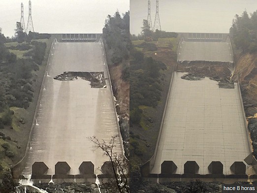
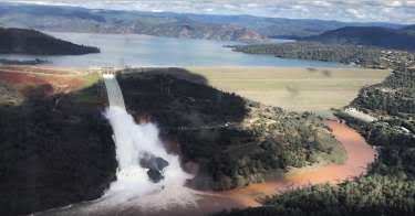
Just so it's clear - the photos in the OP are the primary spillway for this dam, not the emergency spillway. The roaring cascades of white water in
videos are the open and damaged primary spillway dropping into the Feather River.
The emergency "spillway" consists of a low part of the dam. Water is now cascading over that into a basin between the dam and an access road. They expect that to fill but not overtop the roadway. Out of caution, crews did remove a lot of debris between that catch basin and the Feather River below so if the catch basin fills there will be less junk swept downstream.
Engineers noticed the hole earlier this week and temporarily halted flows on the primary to inspect. They determined that the risk of increased damage (as shown in the two OP photos) was worth the risk of needing to rely on the emergency spillway only. That spillway is pretty well destroyed now, but there is still controlled release between the primary gates and the power plant diversion.
The overtopping is expected to trickle off over the next 2-3 days and once lake levels drop to a comfortable point they can shut down the primary and start spending money.
a reply to: Tripnman
ca is a BIG state and I live in it.., I was pretty sure it is in northern ca, but wasn't exactly sure so I had to look up where this is....very much north...it is about an hour (60 miles) north of sacamento
ca is a BIG state and I live in it.., I was pretty sure it is in northern ca, but wasn't exactly sure so I had to look up where this is....very much north...it is about an hour (60 miles) north of sacamento
edit on 11-2-2017 by research100 because: added a space between 2
words
edit on 11-2-2017 by research100 because: dang spelling
originally posted by: Observationalist
The scary thing to me is the deep and wet snowpack in the Sierras. I'm sure this pattern will slowdown and we can dry out a bit, but if we get anything similar in late March early April when all that snow melts, look out, That dam will have a bunch of pressure build up.
Donner Summit snow pack
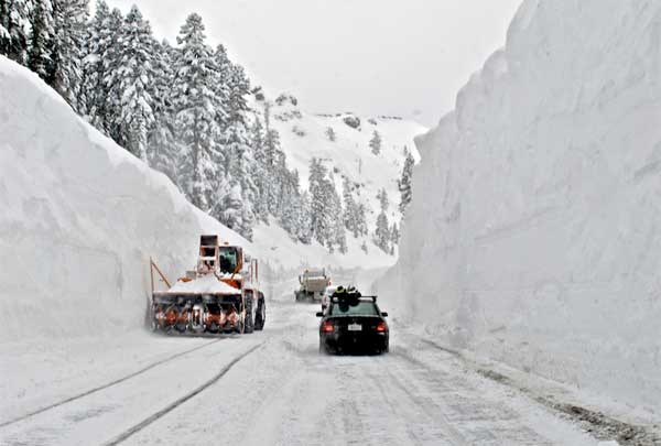
2011
Think it was 2013-2014 driest years on record for 50 years?
This year it is 20+ feet of snow, crazy.
When it melts ...whooosh.
It will all most likely be ok though!
Here is a vid from local KCRA copter this morning,
it is an excellent one, things look under control.
Shows the emergency spillway overflowing into
the (dirt) catch basin. Mind you this was very early
today so not sure but that basin probably filled
and started down the hill next to the dam spillway.
a reply to: burntheships
Here are some current stats on the snowpack water equivalent link
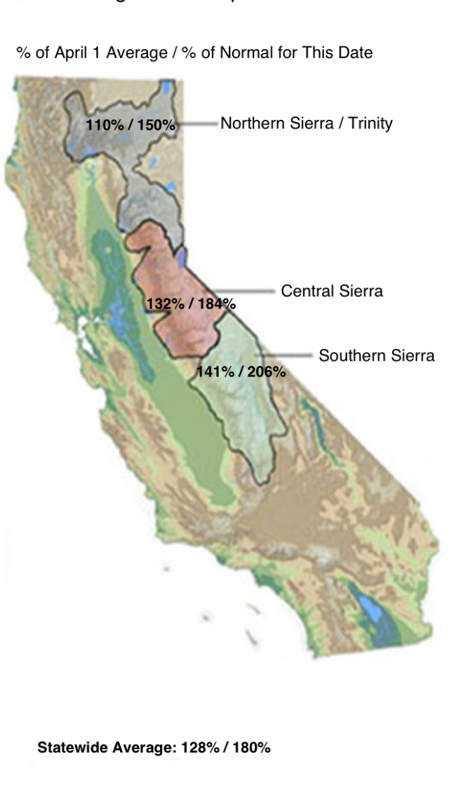
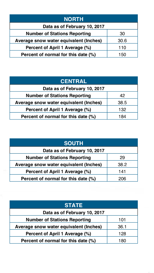
It's not the total amount that worries me its the potential for rapid movement of water, rapid erosion and the increase pressure on poorly maintained dams.
After a month of huge blizzards and “atmospheric river” storms, the Sierra Nevada snowpack — source of a third of California’s drinking water — is 177 percent of the historic average, the biggest in more than two decades.
Here are some current stats on the snowpack water equivalent link
It's not the total amount that worries me its the potential for rapid movement of water, rapid erosion and the increase pressure on poorly maintained dams.
edit on 12-2-2017 by Observationalist because: Remove redundancy
a reply to: Observationalist
Great info thanks!
Snowpack is far above normal! I agree when they get
a warm rain much of it will melt in a short time
and will put pressure on the (poorly maintained) existing systems.
Great info thanks!
Snowpack is far above normal! I agree when they get
a warm rain much of it will melt in a short time
and will put pressure on the (poorly maintained) existing systems.
a reply to: FissionSurplus
Uh huh. Structures are built to last for centuries...
...until they fail.
Uh huh. Structures are built to last for centuries...
...until they fail.
a reply to: corblimeyguvnor
I'm sure the Army Corp of engineers had their hands in it,another one of their many failures,they use bandaids
I'm sure the Army Corp of engineers had their hands in it,another one of their many failures,they use bandaids
originally posted by: corblimeyguvnor
Anyone near here? I have heard the emergency spillway is in serious danger of collapse, and the collapse is going UP, not down, probably due to turbulence in the water.
I heard this an hour ago, melt water is imminent to overtop ....... anyone able to give an update
Thanks
This has been tracked as an issue for a few days now. Another forum had members camped out livestreaming it, seeing as the local reporters were useless.
The dam has only recently hit levels that allowed them to test the spillway - at which point a large hole suddenly appeared. It seems most likely that the lower part/right hand side sits mostly on dirt, while the upper part/left hand side sits on bedrock. For whatever reason the dirt has shifted and allowed the spillway to crack open.
The practical upshot of this, is that they need to limit the amount of water going down the spillway. Too much, and it risks making the hole worse and the water might redirect closer to the dam, causing a more serious erosion risk. They want to keep the water moving as directly as possible into the stream.
The turbine rooms were flooded when the outlet was blocked and water started to back up. This means they can't push water through the lower outlets.
The emergency spillway (the massive weir on the left of the spillway in the photo) is now in use, with excess water stripping a boatload of soil and dumping it into the river. Saying "in use" makes it sound like they have a choice in the matter. Mother Nature and the laws of physics have decided to use it.
All of this is NOT a problem. The emergency spillway is acting exactly as planned.
The problem will come in a few days. The dam is already at limit, the inflow is still slightly higher than the outflow so it's not going to drop significantly any time soon... and then there's projected to be a massive influx of water from incoming weather. When a dam hits overflow, it stops being a flood prevention device - water in will equal water out. So, even if the dam holds perfectly well, there is still the risk of flooding that can overwhelm the two or three dams downstream.
There is also a risk that the breached spillway might allow water to start eroding dirt in areas where they really don't want it eroded, raising the faint possibility of a more serious compromise of the system.
I live in oroville there is no danger to anything or anyone downstream from the spillway, except for erosion. They're just going to let it do its
thing for now and fix it later during the summer
.
.
edit on 12-2-2017 by TheLotLizard because: (no reason given)
edit on 12-2-2017 by TheLotLizard because: (no reason
given)
new topics
-
HORRIBLE !! Russian Soldier Drinking Own Urine To Survive In Battle
World War Three: 1 hours ago -
Bobiverse
Fantasy & Science Fiction: 4 hours ago -
Florida man's trip overseas ends in shock over $143,000 T-Mobile phone bill
Social Issues and Civil Unrest: 4 hours ago -
Former Labour minister Frank Field dies aged 81
People: 6 hours ago -
SETI chief says US has no evidence for alien technology. 'And we never have'
Aliens and UFOs: 8 hours ago -
This is our Story
General Entertainment: 10 hours ago
top topics
-
President BIDEN Vows to Make Americans Pay More Federal Taxes in 2025 - Political Suicide.
2024 Elections: 13 hours ago, 16 flags -
One Flame Throwing Robot Dog for Christmas Please!
Weaponry: 17 hours ago, 6 flags -
Florida man's trip overseas ends in shock over $143,000 T-Mobile phone bill
Social Issues and Civil Unrest: 4 hours ago, 6 flags -
SETI chief says US has no evidence for alien technology. 'And we never have'
Aliens and UFOs: 8 hours ago, 6 flags -
Don't take advantage of people just because it seems easy it will backfire
Rant: 17 hours ago, 4 flags -
Ditching physical money
History: 17 hours ago, 4 flags -
Former Labour minister Frank Field dies aged 81
People: 6 hours ago, 4 flags -
Bobiverse
Fantasy & Science Fiction: 4 hours ago, 3 flags -
This is our Story
General Entertainment: 10 hours ago, 3 flags -
Ode to Artemis
General Chit Chat: 13 hours ago, 3 flags
active topics
-
Breaking Baltimore, ship brings down bridge, mass casualties
Other Current Events • 478 • : IndieA -
Russia Ukraine Update Thread - part 3
World War Three • 5726 • : stu119 -
Thousands Of Young Ukrainian Men Trying To Flee The Country To Avoid Conscription And The War
Other Current Events • 129 • : yuppa -
One Flame Throwing Robot Dog for Christmas Please!
Weaponry • 10 • : ATruGod -
-@TH3WH17ERABB17- -Q- ---TIME TO SHOW THE WORLD--- -Part- --44--
Dissecting Disinformation • 644 • : cherokeetroy -
HORRIBLE !! Russian Soldier Drinking Own Urine To Survive In Battle
World War Three • 8 • : Astyanax -
New whistleblower Jason Sands speaks on Twitter Spaces last night.
Aliens and UFOs • 51 • : Ophiuchus1 -
The Reality of the Laser
Military Projects • 40 • : Zaphod58 -
President BIDEN Vows to Make Americans Pay More Federal Taxes in 2025 - Political Suicide.
2024 Elections • 67 • : UnderAether -
Windows tracking links to WEF and more:
New World Order • 21 • : milaganenogan