It looks like you're using an Ad Blocker.
Please white-list or disable AboveTopSecret.com in your ad-blocking tool.
Thank you.
Some features of ATS will be disabled while you continue to use an ad-blocker.

What's Going On With These Weird Ripply Clouds?
page: 18
share:
What's Going On With These Weird Ripply Clouds?
www.iflscience.com...
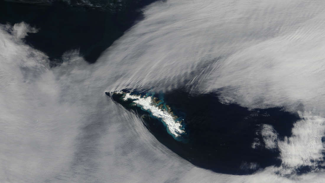
NASA’s Terra satellite acquired this natural-color image on February 2, 2017
Now this is something pretty cool! Imagine seeing this cloud formation above your head and wonder WTH is going on in the sky? You may think HAARP or alien witchcraft, but if you were a scientific observer you may take notes down and explore weather patterns.
So skywatchers, sky gaze away!
www.iflscience.com...
NASA’s Terra satellite acquired this natural-color image on February 2, 2017
This time, the agency snapped a photograph of some dramatically parting clouds between the South Georgia and the South Sandwich Islands. A British overseas territory in the Atlantic Ocean, they’re extremely remote and prone to volcanic eruptions and penguin occupation.
But what is the ripple-like witchcraft happening with the clouds, we hear you ask. Well that, dear readers, is due to a fluid dynamics phenomenon known as a “gravity wave”.
Say you’ve got two fluids, two materials that are mobile and compressible, but with different densities. When the two are in a state of equilibrium of balance, they are motionless.
However, when the system is upset – perhaps due to the chaotic nature of how they are moving against each other or due to local density changes – things fall out of equilibrium and inertial forces attempt to restore the balance...
The motion of the wind on the sea, for example, creates surface waves. This, of course, is the image we normally associate with the word “wave”, which is the sloshing about of the water as the air above tries to reach equilibrium. Water isn’t the only place you get waves, though – any fluid can feature them.
In the case of NASA’s latest satellite image, we have the cloud and the air around it as the two fluids. As the air flowed over the islands, it bunches up and stretches out, causing crests and troughs in the local atmosphere.
As the clouds were present, these crests and troughs became visible to NASA’s satellite peering down from above. So there you have it!
Now this is something pretty cool! Imagine seeing this cloud formation above your head and wonder WTH is going on in the sky? You may think HAARP or alien witchcraft, but if you were a scientific observer you may take notes down and explore weather patterns.
So skywatchers, sky gaze away!
You say gravity waves...others might say its Trump's fault
Not to be picky but those clouds arent "dramatically parting" in my opinion. I call fake news on this one.
Not to be picky but those clouds arent "dramatically parting" in my opinion. I call fake news on this one.
a reply to: Skywatcher2011
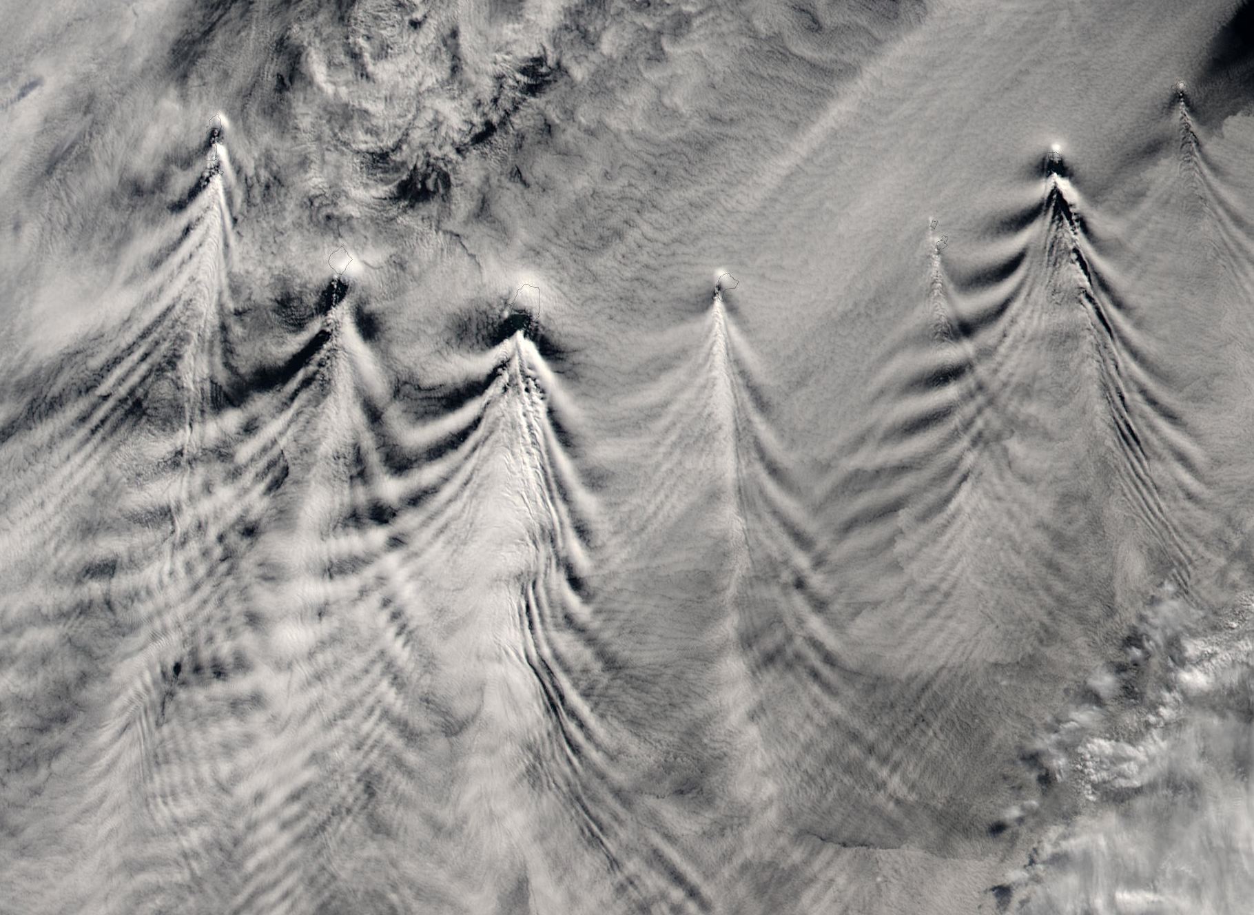
Here's a more dramatic example:
www.atmos.washington.edu...
What they look like from the ground varies. But they are usually dramatic.
www.google.com...
Sailplane pilots like to get up close and personal with them.
www.google.com...
Here's a more dramatic example:
www.atmos.washington.edu...
Imagine seeing this cloud formation above your head and wonder WTH is going on in the sky?
What they look like from the ground varies. But they are usually dramatic.
www.google.com...
Sailplane pilots like to get up close and personal with them.
www.google.com...
edit on 2/7/2017 by Phage because: (no reason given)
The clouds parting around an Island mountain, like a boat makes a wake on water or...
a bullet in flight parting the air: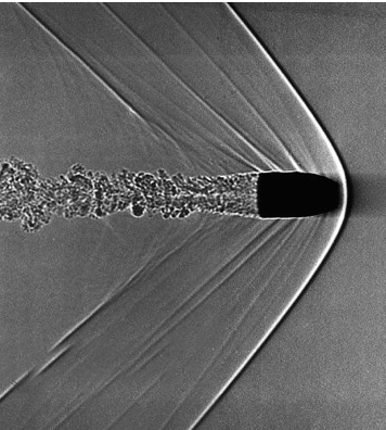
and the earths magnetic field parting the solar wind:
a bullet in flight parting the air:
and the earths magnetic field parting the solar wind:
edit on 7-2-2017 by intrptr because: spelling
originally posted by: ausername
a reply to: six67seven
Wow, even a thread about clouds isn't safe from politics.
thats the kind of climate ATS cultivates and profits from.
---
nice clouds...
From Phage's first link - Christmas Clouds!!
Thank you for the thread, and to all contributors so far - very cool stuff.
No thanks to the political trolling thread derailer though. Why try to ruin a good thing? Just have to be "that guy" who feels the need to infect even the most unrelated thread with politics?
Thank you for the thread, and to all contributors so far - very cool stuff.
No thanks to the political trolling thread derailer though. Why try to ruin a good thing? Just have to be "that guy" who feels the need to infect even the most unrelated thread with politics?
edit on 2/8/2017 by dogstar23 because: Formatting
edit on 2/8/2017 by dogstar23
because: (no reason given)
new topics
-
Ditching physical money
History: 2 hours ago -
One Flame Throwing Robot Dog for Christmas Please!
Weaponry: 2 hours ago -
Don't take advantage of people just because it seems easy it will backfire
Rant: 3 hours ago -
VirginOfGrand says hello
Introductions: 3 hours ago -
Should Biden Replace Harris With AOC On the 2024 Democrat Ticket?
2024 Elections: 4 hours ago -
University student disciplined after saying veganism is wrong and gender fluidity is stupid
Education and Media: 7 hours ago -
Geddy Lee in Conversation with Alex Lifeson - My Effin’ Life
People: 8 hours ago -
God lived as a Devil Dog.
Short Stories: 8 hours ago -
Police clash with St George’s Day protesters at central London rally
Social Issues and Civil Unrest: 9 hours ago -
TLDR post about ATS and why I love it and hope we all stay together somewhere
General Chit Chat: 10 hours ago
top topics
-
Hate makes for strange bedfellows
US Political Madness: 12 hours ago, 20 flags -
Who guards the guards
US Political Madness: 15 hours ago, 13 flags -
University student disciplined after saying veganism is wrong and gender fluidity is stupid
Education and Media: 7 hours ago, 12 flags -
Police clash with St George’s Day protesters at central London rally
Social Issues and Civil Unrest: 9 hours ago, 9 flags -
TLDR post about ATS and why I love it and hope we all stay together somewhere
General Chit Chat: 10 hours ago, 7 flags -
Should Biden Replace Harris With AOC On the 2024 Democrat Ticket?
2024 Elections: 4 hours ago, 5 flags -
Has Tesla manipulated data logs to cover up auto pilot crash?
Automotive Discussion: 17 hours ago, 3 flags -
One Flame Throwing Robot Dog for Christmas Please!
Weaponry: 2 hours ago, 3 flags -
God lived as a Devil Dog.
Short Stories: 8 hours ago, 3 flags -
Don't take advantage of people just because it seems easy it will backfire
Rant: 3 hours ago, 3 flags
active topics
-
Breaking Baltimore, ship brings down bridge, mass casualties
Other Current Events • 470 • : IndieA -
Should Biden Replace Harris With AOC On the 2024 Democrat Ticket?
2024 Elections • 38 • : Lumenari -
One Flame Throwing Robot Dog for Christmas Please!
Weaponry • 5 • : nugget1 -
Hate makes for strange bedfellows
US Political Madness • 37 • : YourFaceAgain -
Candidate TRUMP Now Has Crazy Judge JUAN MERCHAN After Him - The Stormy Daniels Hush-Money Case.
Political Conspiracies • 742 • : Annee -
Ditching physical money
History • 11 • : BernnieJGato -
1980s Arcade
General Chit Chat • 24 • : 5thHead -
Don't take advantage of people just because it seems easy it will backfire
Rant • 4 • : VirginOfGrand -
The Superstition of Full Moons Filling Hospitals Turns Out To Be True!
Medical Issues & Conspiracies • 21 • : VirginOfGrand -
-@TH3WH17ERABB17- -Q- ---TIME TO SHOW THE WORLD--- -Part- --44--
Dissecting Disinformation • 633 • : Justoneman
8