It looks like you're using an Ad Blocker.
Please white-list or disable AboveTopSecret.com in your ad-blocking tool.
Thank you.
Some features of ATS will be disabled while you continue to use an ad-blocker.

Fantastic "bird's eye" views of Mars
page: 1share:
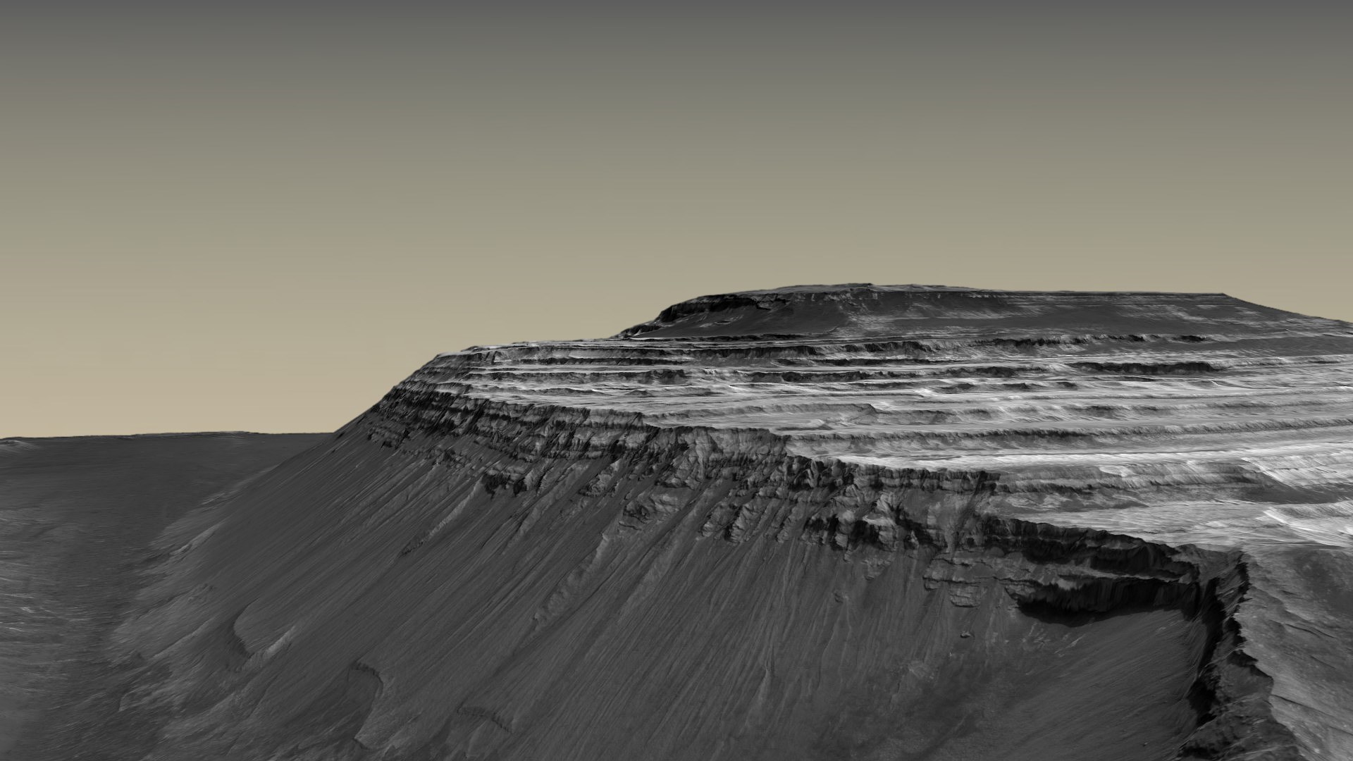
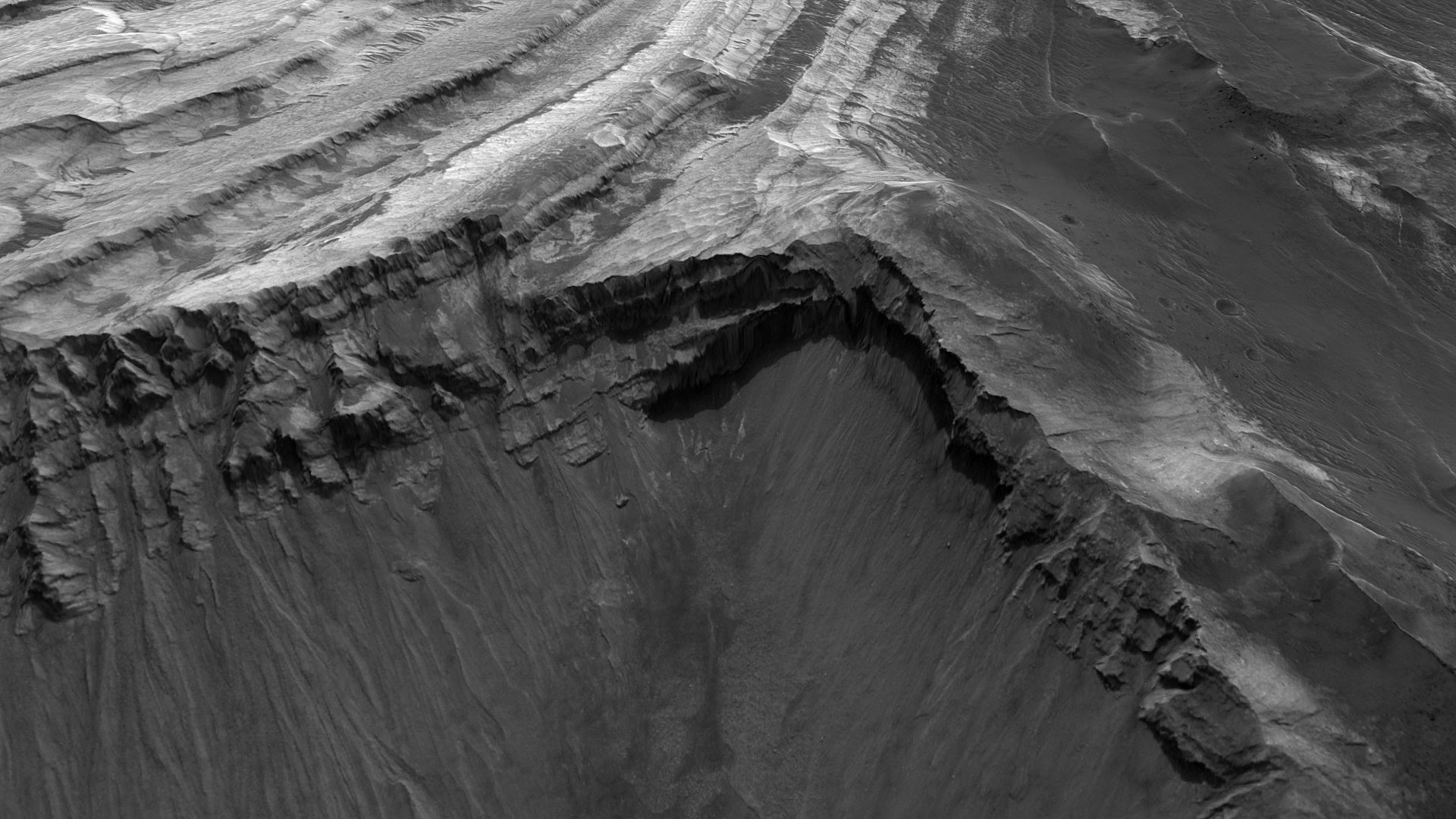
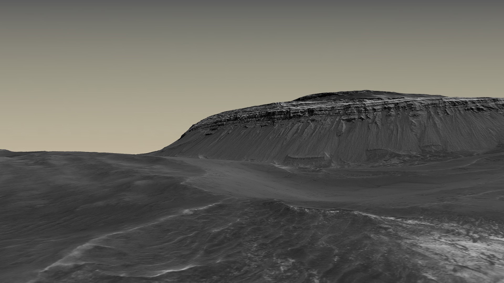
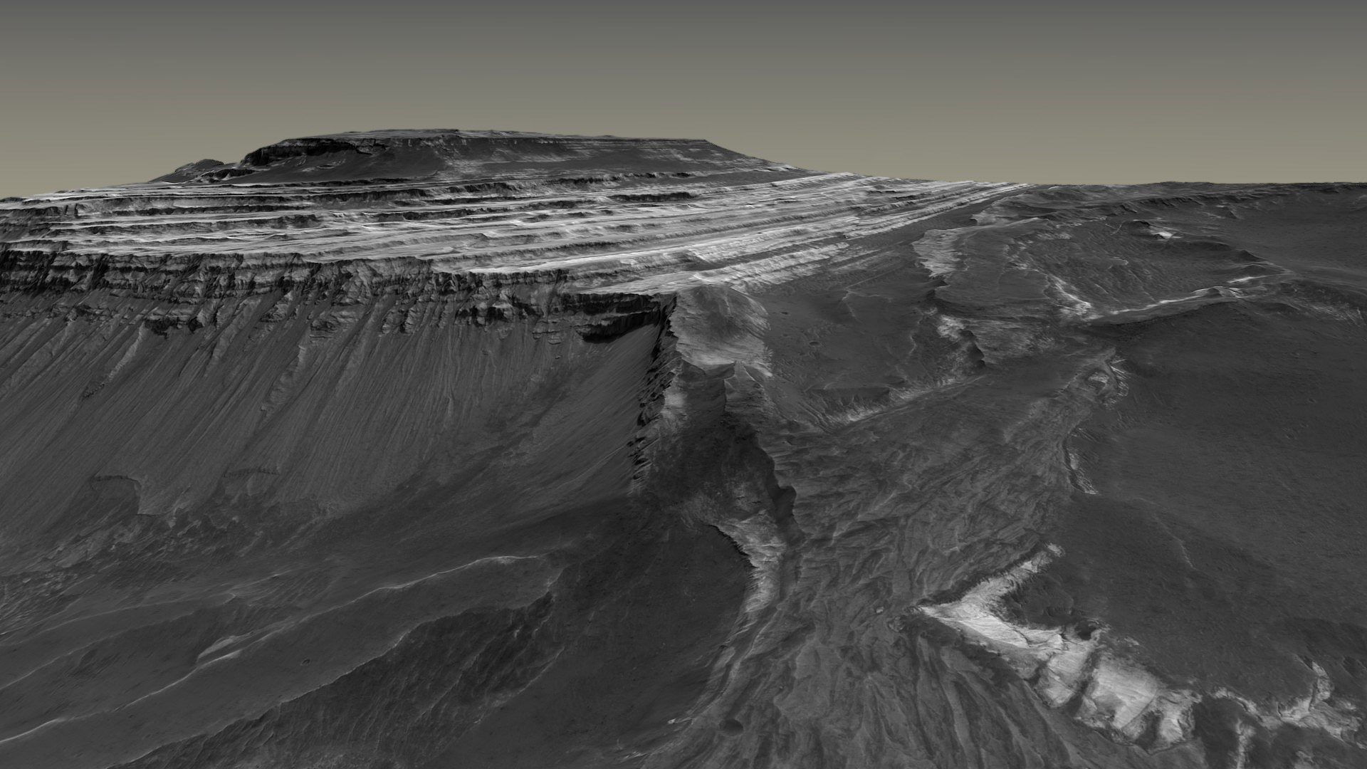
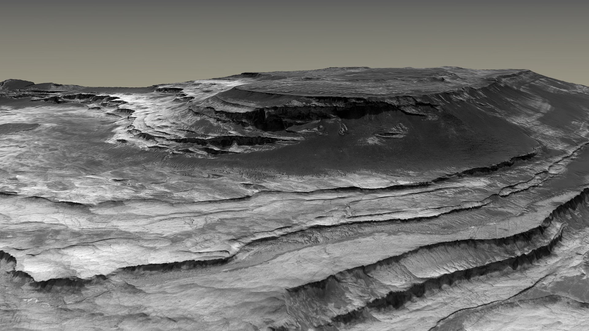
Most of you here already know about Mars Reconnaissance Orbiter (MRO) which orbits Mars and takes very
high-resolution images of its surface. But this orbiter also measures the elevation of the terrain, also at high resolution, giving us the 3D model of
the terrain.
Some space enthusiasts have taken the MRO imagery, overlayed it on the terrain model, and the result is some great simulated "bird's eye" views of Mars, as if you were on a plane or a helicopter and took some photos yourself.
Here are some of such images:
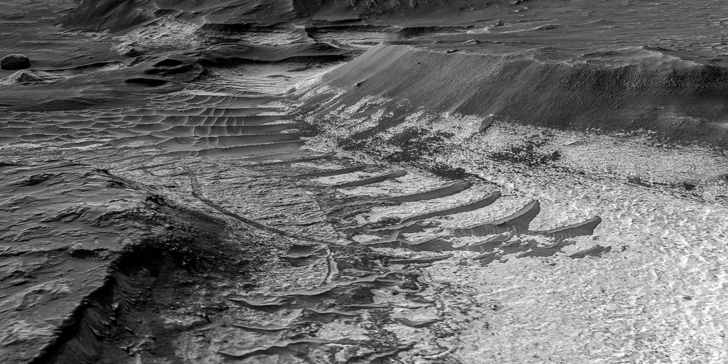
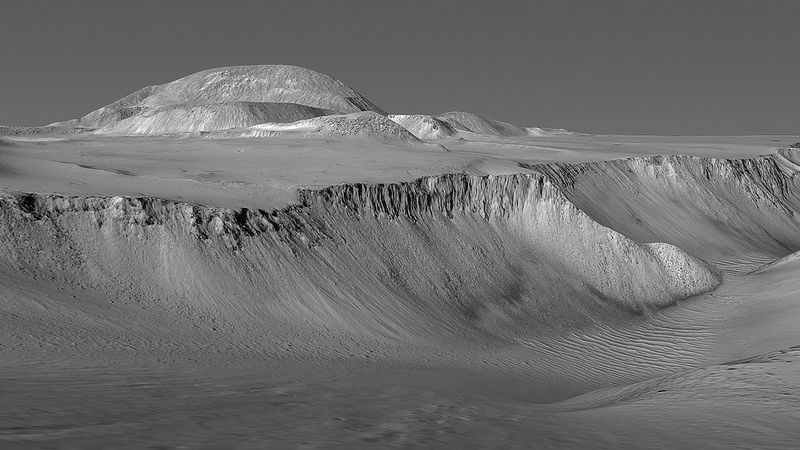
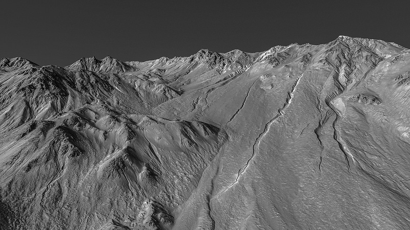
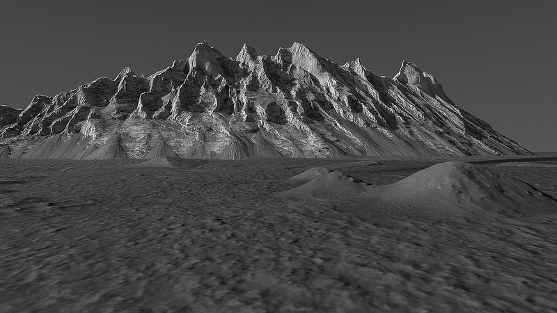
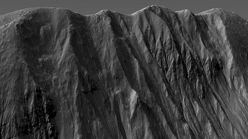
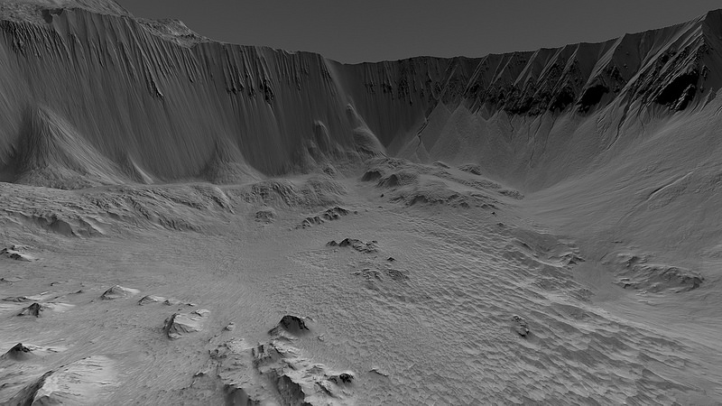
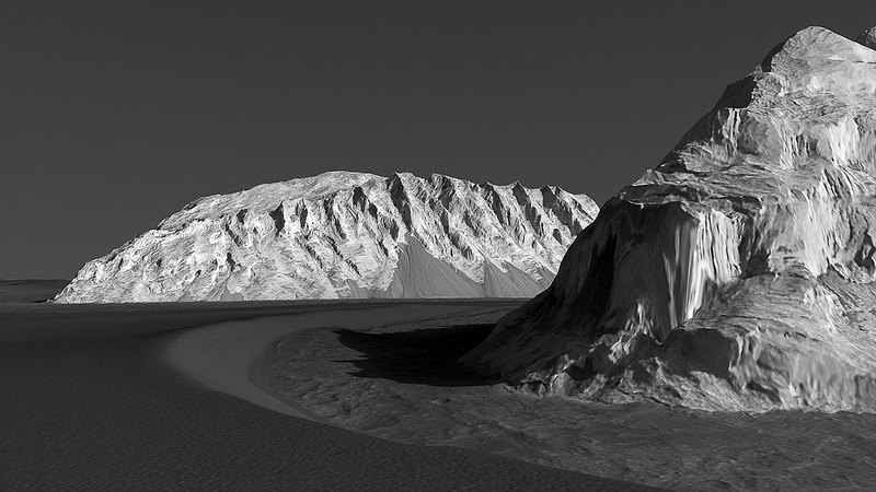
No vertical exagerration was used. Mars is really that craggy and mountainous.
You can find more images and "flyover" videos at the Unmanned Spaceflight Forum and this Flickr album.
I hope you like them as much as I do.
Some space enthusiasts have taken the MRO imagery, overlayed it on the terrain model, and the result is some great simulated "bird's eye" views of Mars, as if you were on a plane or a helicopter and took some photos yourself.
Here are some of such images:
No vertical exagerration was used. Mars is really that craggy and mountainous.
You can find more images and "flyover" videos at the Unmanned Spaceflight Forum and this Flickr album.
I hope you like them as much as I do.
Amazing.
No need to dust it with ridiculous claims about artifacts or fake alien ruins, Mars is fantastic enough as it is.
No need to dust it with ridiculous claims about artifacts or fake alien ruins, Mars is fantastic enough as it is.
a reply to: wildespace
Awesome work.
The elevation layers in those images seem to be much more detailed than those available in Google Mars for some of the HiRISE strips. I knew about the availability of stereo pairs, but I wasn't aware that they offer processed DTMs:
www.uahirise.org...
Implementing them using Blender/Photoshop is a fantastic idea and the results are incredible. S&F!
edit on 8-1-2017 by jeep3r because: text
a reply to: jeep3r
What's incredible is that those DTMs are created from stereo images, not from radar or altimeter data. I didn't realise how much time and work goes into creating them.
Would love to see them and HiRISE imagery used in a sci-fi movie like Martian.
P.S. Anyone know a good free DTM viewing software? I'd like to have a go at those DTMs myself. Mars has some very interesting land features: h irise
edit on 8-1-2017 by wildespace because: (no reason given)
edit on Mon Aug 7 2017 by Jbird because: fix bb code
a reply to: wildespace
I create DTM's daily from drone imagery.
Download Virtual Surveyor.
It is the easiest to use. You literally upload 2 items - your DTM and the sterio ortho.
Bada bing, you have a 3d model
I create DTM's daily from drone imagery.
Download Virtual Surveyor.
It is the easiest to use. You literally upload 2 items - your DTM and the sterio ortho.
Bada bing, you have a 3d model

Great post as always mate. Stunning pics.
So amazing when it dawn on you that this is another planet
So amazing when it dawn on you that this is another planet
a reply to: wildespace
Beautiful, thanks for sharing. The erosion process on Mars look similar to earth, pic 4 reminds me of the Grand Tetons.
Plate tectonics and Water obviously played a huge role in the shaping of those channels.
There must have been an atmosphere at some point to create that weathering.
I assume the wind and and extremely hot and cold cycles continue to erode this vast landscape.
edit on 8-1-2017 by Observationalist because:
Block of text
edit on 8-1-2017 by Observationalist because: (no reason given)
originally posted by: Observationalist
a reply to: wildespace
The erosion process on Mars look similar to earth.
I agree, but interestingly devoid of glacial erosion - as to be expected.
The Martian atmosphere (for the last 2 billion years or so) has been so rarefied that these processes operate at 'glacial' speed. I suspect it's been essentially unchanged in that timeframe, meaning we're looking at Mars as it (mostly) was 2 billion years ago. It's a geological history lesson within our own solar system!
The fact that we still observe briny outflows, landslides, methane releases and dust devils shows that Mars is not a dead place (at least geologically). A truly fascinating place.
a reply to: OneBigMonkeyToo
indeed my friend
im probaly the only ufologist in the world that thinks so!
indeed my friend
im probaly the only ufologist in the world that thinks so!
originally posted by: wildespace
Anyone know a good free DTM viewing software? I'd like to have a go at those DTMs myself. Mars has some very interesting land features: hirise-pds.lpl.arizona.edu...
As far as I know, there's no direct viewing software available. But I managed to convert the HiRISE maps you linked above into some renders using Blender (click thumbnails below for fullsize HD images):


The renders are based on the original DTM files from the HiRISE page incl. a JP2 image overlay. The cool thing about Blender is that it's a free 3D modeling tool and compiling the HiRISE maps yourself isn't too hard (although some basic Blender knowledge is required). An excellent YouTube tutorial on how to import the data into blender is available here.
edit on 10-1-2017 by jeep3r
because: formatting
a reply to: wildespace
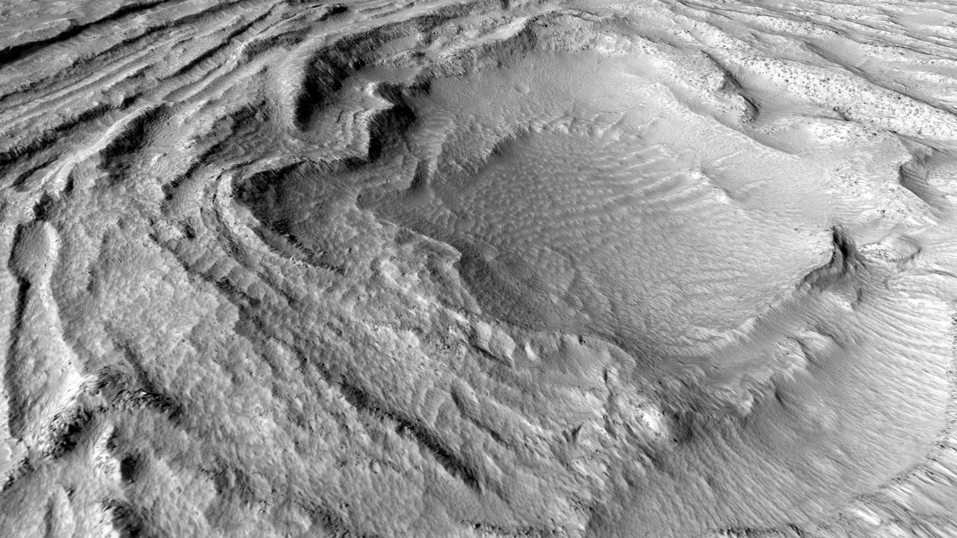
Here's a small tour featuring landforms at Terby crater:
Click below for fullsize versions:
Image 1 | Image 2 | Image 3 | Image 4 | Image 5
Derived from digital terrain model available here: www.uahirise.org...
Here's a small tour featuring landforms at Terby crater:
Click below for fullsize versions:
Image 1 | Image 2 | Image 3 | Image 4 | Image 5
Derived from digital terrain model available here: www.uahirise.org...
edit on 12-1-2017 by
jeep3r because: formatting
originally posted by: jeep3r
a reply to: wildespace
Here's a small tour featuring landforms at Terby crater:
Click below for fullsize versions:
Image 1 | Image 2 | Image 3 | Image 4 | Image 5
Derived from digital terrain model available here: www.uahirise.org...
Nice work mate.
By the way, you guys might want to look into QGIS. Free and amazing
new topics
-
Hurt my hip; should I go see a Doctor
General Chit Chat: 43 minutes ago -
Israel attacking Iran again.
Middle East Issues: 1 hours ago -
Michigan school district cancels lesson on gender identity and pronouns after backlash
Education and Media: 1 hours ago -
When an Angel gets his or her wings
Religion, Faith, And Theology: 2 hours ago -
Comparing the theology of Paul and Hebrews
Religion, Faith, And Theology: 3 hours ago -
Pentagon acknowledges secret UFO project, the Kona Blue program | Vargas Reports
Aliens and UFOs: 4 hours ago -
Boston Dynamics say Farewell to Atlas
Science & Technology: 4 hours ago -
I hate dreaming
Rant: 5 hours ago -
Man sets himself on fire outside Donald Trump trial
Mainstream News: 7 hours ago -
Biden says little kids flip him the bird all the time.
Politicians & People: 7 hours ago
top topics
-
The Democrats Take Control the House - Look what happened while you were sleeping
US Political Madness: 8 hours ago, 17 flags -
In an Historic First, In N Out Burger Permanently Closes a Location
Mainstream News: 10 hours ago, 16 flags -
A man of the people
Medical Issues & Conspiracies: 15 hours ago, 10 flags -
Biden says little kids flip him the bird all the time.
Politicians & People: 7 hours ago, 8 flags -
Man sets himself on fire outside Donald Trump trial
Mainstream News: 7 hours ago, 7 flags -
Pentagon acknowledges secret UFO project, the Kona Blue program | Vargas Reports
Aliens and UFOs: 4 hours ago, 6 flags -
Israel attacking Iran again.
Middle East Issues: 1 hours ago, 5 flags -
Michigan school district cancels lesson on gender identity and pronouns after backlash
Education and Media: 1 hours ago, 4 flags -
Boston Dynamics say Farewell to Atlas
Science & Technology: 4 hours ago, 4 flags -
4 plans of US elites to defeat Russia
New World Order: 17 hours ago, 4 flags
active topics
-
MULTIPLE SKYMASTER MESSAGES GOING OUT
World War Three • 51 • : Zaphod58 -
Israel attacking Iran again.
Middle East Issues • 19 • : stelth2 -
Hurt my hip; should I go see a Doctor
General Chit Chat • 5 • : Caver78 -
Pentagon acknowledges secret UFO project, the Kona Blue program | Vargas Reports
Aliens and UFOs • 7 • : Ophiuchus1 -
-@TH3WH17ERABB17- -Q- ---TIME TO SHOW THE WORLD--- -Part- --44--
Dissecting Disinformation • 549 • : cherokeetroy -
In an Historic First, In N Out Burger Permanently Closes a Location
Mainstream News • 9 • : VariedcodeSole -
When an Angel gets his or her wings
Religion, Faith, And Theology • 1 • : lilzazz -
A man of the people
Medical Issues & Conspiracies • 14 • : chr0naut -
British TV Presenter Refuses To Use Guest's Preferred Pronouns
Education and Media • 68 • : ToneD -
MH370 Again....
Disaster Conspiracies • 9 • : WakeUpBeer