It looks like you're using an Ad Blocker.
Please white-list or disable AboveTopSecret.com in your ad-blocking tool.
Thank you.
Some features of ATS will be disabled while you continue to use an ad-blocker.

Quake Watch 2017
page: 8share:
I made a Tsunami gif animation into a utube vid, 75MB !!! and its only 44 seconds long!!
not very clear is it? play around with the settings a bit, it looks better in Theatre Mode and 1080p
waste of time IMO
here is the original animation 3.5MB
significanteqtsunamis.blogspot.co.nz...
edit on 01000000282817 by muzzy because: (no reason given)
not very clear is it? play around with the settings a bit, it looks better in Theatre Mode and 1080p
waste of time IMO
here is the original animation 3.5MB
significanteqtsunamis.blogspot.co.nz...
edit on 01000000282817 by muzzy because: (no reason given)
F-E Region: Vanuatu Islands
Time: 2017-01-30 23:35:26.3 UTC
Magnitude: 5.8
Epicenter: 167.06°E 14.81°S
Depth: 99 km
Status: A - automatic
geofon.gfz-potsdam.de...
not on USGS yet
edit: here it is now 5.9mb
earthquake.usgs.gov...
slow, at least 1/4hr after I seen it on GFZ, who knows how long it was on GFZ before I noticed.
Unfortunately GFZ don't have a seismo station nearby, Port Moresby is the nearest. It was showing it
geofon.gfz-potsdam.de...
IRIS have a closer station at Honiara Solomon Islands, but not showing yet.
edit on 01000000292917 by muzzy because: (no reason given)
I did another Tsunami Animation from 2015, from the Santa Cruz/Solomon Islands pingpong series
6.9Mww, 2015/5/22 21:45, Solomon Islands
in addition to the one I did the other day6.8Mww, 2015/5/20, Santa Cruz Islands Region
Now I have two done I started to compare.
On both I have done a second animation just of San Cristobal Island.
I picked 2 locations Santa Ana Is, at the tip of San Cristobal, and Naana a bit further up the East Coast.
The M6.9 quake was closer, so the times were shorter (obviously)
but for some reason the M6.8 quake, further away, got bigger heights on San Cristobal Is than the 6.9.
I decided to check the possible speed of the Tsunami.
20/5/2015 6.8 (-10.8886,164.1581)
@ 183.3 km from Santa Ana Is (-10.84162.48) took 18 minutes
@ 216.5km from Naana (-10.66162.19) took 28 minutes
6.8 quake San Cristobal animation
22/5/2015 6.9 (-11.0723,163.6837)
@ 133.9 km Santa Ana Is took 8 minutes
@ 169.4 km from Naana took 15 minutes
6.9 quake San Cristobal animation
If you open both animations in separate windows you can compare the different arrivals, but it is hard to match up the times, as the first one (M6.8) starts at 0.08 minutes and the second one (M6.9) starts at 00:16 minutes. To do it perfectly I would have to run through 72 images per animation to tag each minute, the file would be huge and I would be mentally exhausted.
So calculation speed from that
Quake, Arrival, km/Minutes, Speed,=Conversion,
6.9, Santa Ana Is, 133.9/8, 16.74km/minute=(1004km/hr)
6.9, Naana, 169.4/15, 11.29km/minute=(677.4km/hr)
6.8, Santa Ana Is, 183.3/18, 10.18km/minute=(610.8km/hr)
6.8, Naana, 216.5/28, 7.73km/minute=(463.8km/hr)
Holy Cowabunga! thats FAST, about the speed of a commercial airplane, an F-16 in one case!!!!!
Is there any mathamatician readers who can check this out?
are my calculations right?.
From watching the Japan tsunami videos I always thought they came in slowly, but powerfully, not like a freight train with a jet engine.
There are 3 more quakes in the southern part of this series to do yet, a 6.8 two and a quarter hours later same day as the 6.9, a 6.6 on 15/8 and the big daddy a 7.0 on 18/7
then 4 more in the northern part (NW of Guadacanal) in the months following
I already did the trigger quake, the 7.2 off Bougainville Is. 7/5/2015
a reply to: muzzy
It appears these figures are correct
news.nationalgeographic.com...
and
ptwc.weather.gov...
Wow
It appears these figures are correct
news.nationalgeographic.com...
and
ptwc.weather.gov...
Wow
Biggest one for a while down there, should have felt it here but was asleep
Public ID 2017p084950
Intensity strong
Universal Time February 1 2017, 10:21:29
NZ Daylight Time Wed, Feb 1 2017, 11:21:29 pm
Depth 16 km
Magnitude 5.1
Location 10 km north-east of Kaikoura
Latitude, Longitude -42.31, 173.76
www.geonet.org.nz...
2089 felt reports, mostly Kaikoura, Blenhiem and Wellington
589.94TTNT energy released
edit on 02000000313117 by muzzy because: (no reason given)
Another couple in Australia
Date and Time
UTC: 31 January 2017 @ 19:40:15
Location SW of Boolarra, VIC. (Reported felt).
Coordinates: -38.455, 146.225
Depth: 10 km
Magnitude
ML: 3.5
Solution status
Last updated: 01 February 2017 @ 10:10:22 (AEDT)
Solution reviewed: Yes
Source: AUST
Date and Time
UTC: 01 February 2017 @ 13:37:56
Location 9km SW of Murray Bridge, SA (reported felt).
Coordinates: -35.152, 139.155
Depth: 8 km
Magnitude
ML: 3.7
Solution status
Last updated: 02 February 2017 @ 01:47:22 (AEDT)
Solution reviewed: No
www.ga.gov.au...
Date and Time
UTC: 31 January 2017 @ 19:40:15
Location SW of Boolarra, VIC. (Reported felt).
Coordinates: -38.455, 146.225
Depth: 10 km
Magnitude
ML: 3.5
Solution status
Last updated: 01 February 2017 @ 10:10:22 (AEDT)
Solution reviewed: Yes
Source: AUST
Date and Time
UTC: 01 February 2017 @ 13:37:56
Location 9km SW of Murray Bridge, SA (reported felt).
Coordinates: -35.152, 139.155
Depth: 8 km
Magnitude
ML: 3.7
Solution status
Last updated: 02 February 2017 @ 01:47:22 (AEDT)
Solution reviewed: No
www.ga.gov.au...
edit on 1-2-2017 by Leanansidhe because: (no reason
given)
a reply to: Leanansidhe
I felt that one. It was cool as.
Woke me up with the windows rattling and the bed shaking. Awesome.
The last one I felt was back in the sixties.
We don't get many
P
Date and Time UTC: 01 February 2017 @ 13:37:56 Location 9km SW of Murray Bridge, SA (reported felt). Coordinates: -35.152, 139.155 Depth: 8 km Magnitude ML: 3.7 Solution status Last updated: 02 February 2017 @ 01:47:22 (AEDT) Solution reviewed: No
I felt that one. It was cool as.
Woke me up with the windows rattling and the bed shaking. Awesome.
The last one I felt was back in the sixties.
We don't get many
P
a reply to: Leanansidhe
After I had a look at the link to the Muray Bridge quake I went back to the GeoAu main page and seen this
www.ga.gov.au...
UTC: 02 February 2017 @ 05:05:33
Location Off East Coast of North Island, NZ.
Coordinates: -38.143, 178.431
Depth: 38 km
Magnitude
Mb: 5.3
eh?
didn't see that one on Geonet?
a bit of searching using the time 05:05:39 brought up a 4.8 on the other side of East Cape
Missed by 87km (54 miles)!
www.geonet.org.nz...
a reply to: muzzy
Had a look on USGS this morning, they have it at 5.2 and half way between Geonet and GeoAu
earthquake.usgs.gov...
and GFZ 4.9 near USGS
geofon.gfz-potsdam.de...
all a bit vague regarding location eh
based on the felt reports on Geonet I'd say it was on the western side of East Cape
as far as the magnitudes go Geonet is ML, the others are mb, so the difference there is understandable.
Not an accurate analysis of this quake at all by the Networks.
One would expect better for a quake this size.
further to: muzzy
Na the other guys got it wrong, why would there be 8 aftershocks right around Geonets location if the quake was on the East Cape Peninsula or to the East of Tokomaru Bay?
have a look yourself
nzeq2017.blogspot.co.nz...
That is why I tend to go with the locals for location, whether it be NZ, Chile, Japan, Italy etc
a reply to: wasobservingquietly
was along day, took me 3 hours to get home 50km, Long weekend holiday traffic, I was a bit tired by the time I did the page, didn't even notice I had added 8 months to the year!
thanks I will fix it this morning.
edit: fixed it just now, but due to the quirks of Blogger, the address remains nzeq2017.blogspot.co.nz/2017/02/02202017dothtml
edit on
02000000333317 by muzzy because: (no reason given)
3 x mag 4s Central Italy on GFZ
geofon.gfz-potsdam.de...
*I don't have INGV on my phone
edit later:
To the north of Norcia, opposite end of the aftershock series from those 5's in Jan.
INGV had the last one at 3.8 (not GFZ's 4.2)
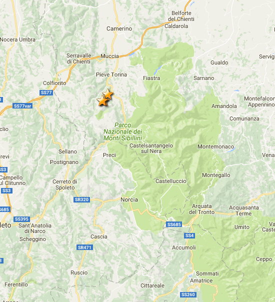
location amongst the last 8310 events I downloaded on 23.01.2017
geofon.gfz-potsdam.de...
*I don't have INGV on my phone
edit later:
To the north of Norcia, opposite end of the aftershock series from those 5's in Jan.
INGV had the last one at 3.8 (not GFZ's 4.2)
location amongst the last 8310 events I downloaded on 23.01.2017
edit on 02000000333317 by muzzy because: (no reason given)
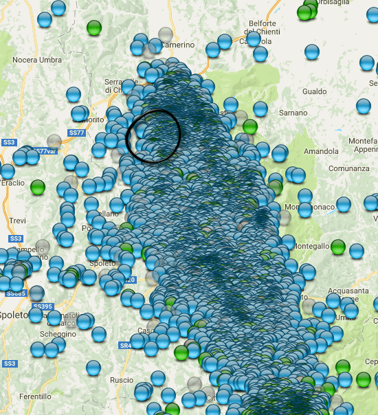
further to: muzzy
Just did a download of ISIDe/INGV Italy, 70km radius from Norcia since 22.01.2017, which was 4 days after those M5s
4719 aftershocks!!!
holy macaroni!
this is the biggest earthquake series in at least a decade, Mexicali 2010 is the only other one that comes close which at the 2 month mark was 3000 events behind Norcia, and that was a 7.1
Accumoli/Norcia combined is now well over the 50,000 count.
52,282 to be precise.
But it might be more than that, as when I started archiving the aftershocks I only went 50km radius from Visso, so might have missed some of the more southern events towards L'Aquilla. That was all of the 2016 period.
At some point I will start from scratch at the 70km distance.
Yeah, just did another download from 24.08.2016, the day of the Accumoli M6.0
#Terremoti totali: 53,310
I will need to trim that down though, as 70km radius going west and east from Norcia takes in a huge area which is probably not related directly to this series (background activity along the coasts)
because the maps can only take 10,000 icons each and I was already on the 6th map for the page, I am going to split that last 10,000 map and start a new one from the 18th with the multiple 5's. Hopefully more maps with less icons will load quicker. I'm calling this latest map the "Montereale Series", that is the nearest town, pop 2600, and this part of the whole series has already had 6498 aftershocks since 18.01.2017.
Monterealehas a an earthquake history, destroyed in the the L'Aquila earthquake of 1703.
I haven't got time right now to process the data into maps right now, the best way to see what has been happening the last few weeks is the
timeline graph
Just did a download of ISIDe/INGV Italy, 70km radius from Norcia since 22.01.2017, which was 4 days after those M5s
4719 aftershocks!!!
holy macaroni!
this is the biggest earthquake series in at least a decade, Mexicali 2010 is the only other one that comes close which at the 2 month mark was 3000 events behind Norcia, and that was a 7.1
Accumoli/Norcia combined is now well over the 50,000 count.
edit on 02000000343417 by muzzy because: (no reason given)
52,282 to be precise.
But it might be more than that, as when I started archiving the aftershocks I only went 50km radius from Visso, so might have missed some of the more southern events towards L'Aquilla. That was all of the 2016 period.
At some point I will start from scratch at the 70km distance.
edit on 02000000343417 by muzzy because: (no reason given)
Yeah, just did another download from 24.08.2016, the day of the Accumoli M6.0
#Terremoti totali: 53,310
I will need to trim that down though, as 70km radius going west and east from Norcia takes in a huge area which is probably not related directly to this series (background activity along the coasts)
edit on 02000000343417 by muzzy because: (no reason given)
because the maps can only take 10,000 icons each and I was already on the 6th map for the page, I am going to split that last 10,000 map and start a new one from the 18th with the multiple 5's. Hopefully more maps with less icons will load quicker. I'm calling this latest map the "Montereale Series", that is the nearest town, pop 2600, and this part of the whole series has already had 6498 aftershocks since 18.01.2017.
Monterealehas a an earthquake history, destroyed in the the L'Aquila earthquake of 1703.
I haven't got time right now to process the data into maps right now, the best way to see what has been happening the last few weeks is the
timeline graph
edit on 02000000343417 by muzzy
because: (no reason given)
a reply to: muzzy
Yeah I'm just comparing the older data for Accumoli/Visso/Norcia with what I downloaded this morning,
there are significant differences,
take the first line/event after the Accumoli M6.0
UTC, Lat, Long, Depth, Mag
old
24/08/2016 01:37:26 , 42.72,13.253, 6.9km, 1.9ML
new
24/08/2016 01:37:27, 42.712,13.253, 9km, 4.5ML
If this is just one example, it will likely change the TTNT count throughout the whole series
M6.1 >> M 5.9 - Fiji Islands Region Downgraded
Location in IRIS Earthquake Browser
- Date-Time: Saturday, January 14, 2017 @ 06:11:40 UTC
- Earthquake location: 18.621°S, 176.236°E,
- Earthquake depth: 3.9 km
- Event ID: us10007t8x
Derived from Event Data Source: USGS
Powered by QVSData
a reply to: PuterMan
I'm confused. (I just woke up)
EMSC has it as a 6.0
www.emsc-csem.org...
IRIS still has it as a 6.1
ds.iris.edu... me-desc&limit=10&maxlat=-12.66&minlat=-24.47&maxlon=-171.40&minlon=163.64&pbl=1&caller=qvs&zm=6&mt=ter
USGS has it as a 5.9
earthquake.usgs.gov...-info
I have been working alot and not able to play.
Did USGS just downgrade it?
I'm confused. (I just woke up)
EMSC has it as a 6.0
www.emsc-csem.org...
IRIS still has it as a 6.1
ds.iris.edu... me-desc&limit=10&maxlat=-12.66&minlat=-24.47&maxlon=-171.40&minlon=163.64&pbl=1&caller=qvs&zm=6&mt=ter
edit on 5-2-2017 by crappiekat because: to add link
USGS has it as a 5.9
earthquake.usgs.gov...-info
edit on 5-2-2017 by crappiekat because: to add link
I have been working alot and not able to play.
Did USGS just downgrade it?
edit on 5-2-2017 by crappiekat because: to add
new topics
-
Electrical tricks for saving money
Education and Media: 3 hours ago -
VP's Secret Service agent brawls with other agents at Andrews
Mainstream News: 4 hours ago -
Sunak spinning the sickness figures
Other Current Events: 5 hours ago -
Nearly 70% Of Americans Want Talks To End War In Ukraine
Political Issues: 5 hours ago -
Late Night with the Devil - a really good unusual modern horror film.
Movies: 7 hours ago -
Cats Used as Live Bait to Train Ferocious Pitbulls in Illegal NYC Dogfighting
Social Issues and Civil Unrest: 8 hours ago -
The Good News According to Jesus - Episode 1
Religion, Faith, And Theology: 10 hours ago
top topics
-
Cats Used as Live Bait to Train Ferocious Pitbulls in Illegal NYC Dogfighting
Social Issues and Civil Unrest: 8 hours ago, 8 flags -
Florida man's trip overseas ends in shock over $143,000 T-Mobile phone bill
Social Issues and Civil Unrest: 15 hours ago, 8 flags -
VP's Secret Service agent brawls with other agents at Andrews
Mainstream News: 4 hours ago, 8 flags -
Former Labour minister Frank Field dies aged 81
People: 17 hours ago, 4 flags -
HORRIBLE !! Russian Soldier Drinking Own Urine To Survive In Battle
World War Three: 12 hours ago, 3 flags -
Nearly 70% Of Americans Want Talks To End War In Ukraine
Political Issues: 5 hours ago, 3 flags -
Sunak spinning the sickness figures
Other Current Events: 5 hours ago, 3 flags -
Bobiverse
Fantasy & Science Fiction: 15 hours ago, 3 flags -
Electrical tricks for saving money
Education and Media: 3 hours ago, 3 flags -
Late Night with the Devil - a really good unusual modern horror film.
Movies: 7 hours ago, 2 flags
active topics
-
President BIDEN Vows to Make Americans Pay More Federal Taxes in 2025 - Political Suicide.
2024 Elections • 136 • : ImagoDei -
Electrical tricks for saving money
Education and Media • 3 • : Mike72 -
TLDR post about ATS and why I love it and hope we all stay together somewhere
General Chit Chat • 10 • : theshadowknows -
VP's Secret Service agent brawls with other agents at Andrews
Mainstream News • 31 • : WeMustCare -
Why to avoid TikTok
Education and Media • 20 • : 5thHead -
How ageing is" immune deficiency"
Medical Issues & Conspiracies • 32 • : annonentity -
-@TH3WH17ERABB17- -Q- ---TIME TO SHOW THE WORLD--- -Part- --44--
Dissecting Disinformation • 657 • : daskakik -
HORRIBLE !! Russian Soldier Drinking Own Urine To Survive In Battle
World War Three • 30 • : DaRAGE -
Spectrophilia - Women Who Have Had Affairs With Ghosts Say Spooks Are Better Lovers Than Real Men
Paranormal Studies • 32 • : burritocat -
Cats Used as Live Bait to Train Ferocious Pitbulls in Illegal NYC Dogfighting
Social Issues and Civil Unrest • 18 • : Xtrozero