It looks like you're using an Ad Blocker.
Please white-list or disable AboveTopSecret.com in your ad-blocking tool.
Thank you.
Some features of ATS will be disabled while you continue to use an ad-blocker.

Quake Watch 2017
page: 13share:
update on Kaharua Swarm posted by: muzzy
Went over 500 events yesterday at noon.
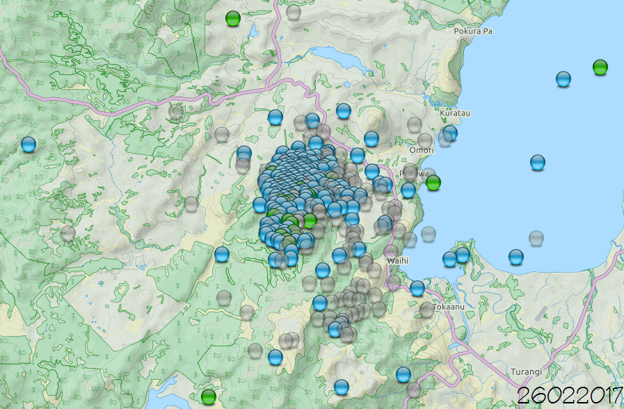
I made a couple of animations to see where it was headed
slightly to the south side of the Cone, but also scattered all over the area
Kaharua Swarm page
This is north of the massive June/July 2009 850 event Swarm when the Waihi Village had to be evacuated.
2009 Swarm
And south of the smaller 115 events Swarm at
Poukura Pa in Nov 2016
Went over 500 events yesterday at noon.
I made a couple of animations to see where it was headed
slightly to the south side of the Cone, but also scattered all over the area
Kaharua Swarm page
This is north of the massive June/July 2009 850 event Swarm when the Waihi Village had to be evacuated.
2009 Swarm
And south of the smaller 115 events Swarm at
Poukura Pa in Nov 2016
edit on 02000000575717 by
muzzy because: (no reason given)
Well, It's that time of year again in the PNW.
Earthquake Season (Slow Slip)
We have had some great conversations here in Quake Watch about this. One of our members Olivine has posted some very informative articles here. If you go into the archives and look there is more information.
This article dated February 27, 2017 talks about the risk of a major earthquake in the Pacific Northwest caused by a phenomenon that causes tectonic plates to move.
It's not a long article.
weather.com...
a reply to: crappiekat
The last slow slip event was in Dec 2015 so I don't see how it is "seasonal"
Seasons happen every year at the same time.
It is currently Feb.
weather.com...
24 months is not a season.
The last slow slip event was in Dec 2015 so I don't see how it is "seasonal"
Seasons happen every year at the same time.
It is currently Feb.
Every 24 months, the Cascadia subduction zone, which runs from northern Vancouver Island down to northern California, undergoes what seismologists call a "slow slip."
weather.com...
24 months is not a season.
edit on 02000000585817 by muzzy because: (no reason given)
Here it indicates that it's every 14 months, which is what I have seen from a number of sources, and that's give or take.
www.cbc.ca...
www.cbc.ca...
edit on 28-2-2017 by AlexanderM because: (no reason given)
a reply to: crappiekat
Yes indeed, there has been some moderate action there lately.
I have been slack, 10 days since I last did a download from NIED
and 15 days since I updated E off Fukushima where most of these have been
Will get onto it today.
Last 10 days Summary to 27/02/2017 14:59:29 UTC
mag~1= 3811
mag1= 2153
mag2= 503
mag3= 104
mag4= 28
mag5= 3
mag6= 0
mag7= 0
total= 6602
So thats not counting the 5.6 yesterday UTC
www.jma.go.jp...
a reply to: AlexanderM
Well I quoted what CBC said on the linked text " increases the odds of a major earthquake event in British Columbia" off crappiekats weatherdotcom link when I opened it on my phone, it said 24 months.
That is why I mentioned it.
The original link weatherdotcom story still says 24 months.
I haven't got time right now, but someone could look through these and confirm or not whether this is fake news. I see 4 seasons on the list, so there is no "season" for these tremors.
Tremor log index:
ETS event of Winter 2003
ETS event of Spring 2004
ETS event of Summer 2005
ETS event of Fall-winter 2006
ETS event of Winter 2008
ETS event of Summer 2009
ETS event of Summer 2010
ETS event of Summer 2011
ETS event of Summer-Fall 2012
ETS event of Fall 2013
ETS event of Winter 2014
ETS event of Winter 2015 - 2016
ETS Event of Winter 2017
www.pnsn.org...
I'm not saying that the tremors are not happening, I'm saying the CBC needs to get the story straight, and report the facts correctly, not make something that is pretty random in time seem like it happens the same time every year (or watever period).
So this has been recorded since 2003 by PNSN? hardly a long enough period of time to come out predicting the M9 is imminent.
What about prior to 2003? surely it didn't just suddenly start 14 years ago?
Probably been going on since 1700 when the last big one hit.
Well I quoted what CBC said on the linked text " increases the odds of a major earthquake event in British Columbia" off crappiekats weatherdotcom link when I opened it on my phone, it said 24 months.
That is why I mentioned it.
The original link weatherdotcom story still says 24 months.
I haven't got time right now, but someone could look through these and confirm or not whether this is fake news. I see 4 seasons on the list, so there is no "season" for these tremors.
Tremor log index:
ETS event of Winter 2003
ETS event of Spring 2004
ETS event of Summer 2005
ETS event of Fall-winter 2006
ETS event of Winter 2008
ETS event of Summer 2009
ETS event of Summer 2010
ETS event of Summer 2011
ETS event of Summer-Fall 2012
ETS event of Fall 2013
ETS event of Winter 2014
ETS event of Winter 2015 - 2016
ETS Event of Winter 2017
www.pnsn.org...
edit on 02000000585817 by muzzy because: (no reason given)
I'm not saying that the tremors are not happening, I'm saying the CBC needs to get the story straight, and report the facts correctly, not make something that is pretty random in time seem like it happens the same time every year (or watever period).
So this has been recorded since 2003 by PNSN? hardly a long enough period of time to come out predicting the M9 is imminent.
What about prior to 2003? surely it didn't just suddenly start 14 years ago?
Probably been going on since 1700 when the last big one hit.
edit on 02000000585817 by muzzy because: (no reason given)
Just google and watch the show "Monster Quake, Are We There Yet," which was made after the Japan quake and tsunami, there is information in the
program about the 14 month interval, which may include background information such as when it was first noticed, etc.
a reply to: crappiekat
Nope, no puter yet. On Saturday the repair shop said they would order the motherboard in the next 20 minutes (having discussed which one with me) Monday I get a call to say the job will take a little long and the new motherboard had blownand the power supply was gone. (It was fine whan I last spoke to them)mSo I wnet in and spoke to the man doing the work. He said not the motherbaord had not come in as he had only ordered it that morning. And yes the power supply and everthing else was OK.
How I managed to walk out whilst still keeping my cool I don't know. Must be mellowing in my old age. A few years ago I would have shredded them.
Sigh! Never again will I be lazy and take a computer in for repair.
a reply to: crappiekat
What you need is QVSData!
Prov,EQ ID,Net Src,Date/Time UTC,Latitude,Longitude,Magnitude,Depth(Km),Location,Status
aust,3937958, AUST, 2017-02-28 00:30:15, -31.792, 138.618, 2.5, 10.0, NE Of Hawker. Sa., F
aust,3937480, AUST, 2017-02-27 19:55:08, -19.891, 148.784, 3.0, 10.0, Offshore NE Of Bowen. Qld., F
aust,3937467, AUST, 2017-02-26 17:41:15, -24.785, 112.877, 3.2, 10.0, Offshore W Of Carnarvon. Wa., F
aust,3937240, AUST, 2017-02-26 00:31:05, -36.281, 148.755, 1.7, 10.0, Nr. Berridale. Nsw., F
aust,3937133, AUST, 2017-02-24 03:14:36, -32.500, 122.264, 2.8, 10.0, SE Of Norseman. Wa., F
aust,3935793, AUST, 2017-02-22 14:45:53, -25.528, 129.864, 3.4, 10.0, Petermann Ranges. Nt., F
aust,3935787, AUST, 2017-02-22 13:18:54, -30.672, 118.437, 2.3, 10.0, SE Of Bonnie Rock. Wa., F
What you need is QVSData!
Date and Time
UTC: 26 February 2017 @ 17:41:15
Location Offshore W of Carnarvon, WA.
Coordinates: -24.785, 112.877
Depth: 10 km
Magnitude
ML: 3.2
Solution status
Last updated: 28 February 2017 @ 09:27:42 (AEDT)
Solution reviewed: Yes
Source: AUST
www.ga.gov.au...
UTC: 26 February 2017 @ 17:41:15
Location Offshore W of Carnarvon, WA.
Coordinates: -24.785, 112.877
Depth: 10 km
Magnitude
ML: 3.2
Solution status
Last updated: 28 February 2017 @ 09:27:42 (AEDT)
Solution reviewed: Yes
Source: AUST
www.ga.gov.au...
a reply to: muzzy
Its all very well living in the future, but you do have to pay attention!
One advantage of using Blogger to post the daily maps for japan is that when I get behind and then do a big update I can still set the posting date for back on the day in question, and the posts still come out in the correct order.
Only problem is that NZ is half a day ahead of UTC, so when you don't pay attention and the month flips over you can, as I did yesterday, the 1st March NZDT, post a whole load of daily maps that you can't see on the published site
The reason being that I "backdated" the date to March 18,19,20, and so on by mistake, instead of February.
Took me a while to realize why I couldn't see the dates in question Doh
All fixed this morning.
Seasonal. Ha. Stupid weather has messed up my observations. However, there is an earthquake in the mid-Altantic, and there's a storm atop the spot.
This year has been super slow and I'm blaming the weather. I'll make a brief comment and cut it short before I starting raving and ranting. Last
night, here in Southern Ontario, Canada, we had a thunder storm. Every couple of days we break a heat record. I remember being a kid, it was wasn't
like this then. I'll stop.
Now, for something completely different. And almost insignificant. Europe and Asia jiggle a little in a little cluster.
Alaska seems to be saying hello. They could have a big one anytime.
Also, one last thing. I'm going to call the swarm of Northern Nevada over. There's been almost nothing lately. Challis had a tiny one.
edit on
1-3-2017 by ericblair4891 because: (no reason given)
a reply to: ericblair4891
Yes that's that Northern Hemisphere Warming. (Not Global Warming)
We have had the crappiest Summer in 30+ years over Dec-middle of Feb
Its come on now end of Feb. , but it feels like a mix of Summer and Fall, warm during the day (22C+) then down to 10-12C at night, heavy dew every morning.
that's that Southern Hemisphere Cooling. (Not Global Warming)
I blame the 2011 Japan M9 earthquake, threw the Planet off balance
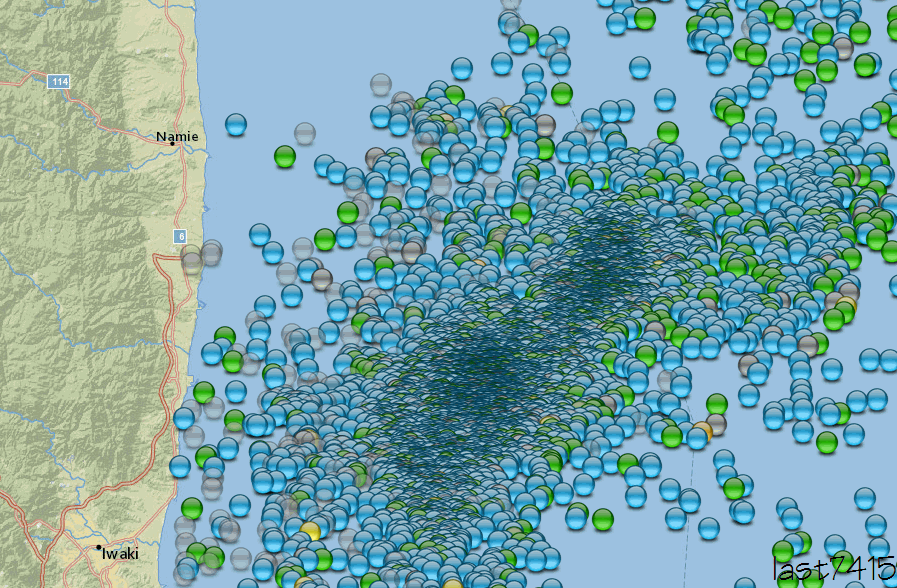
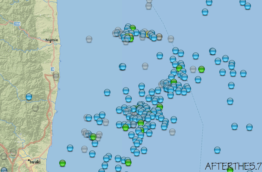
That 5.7 off Namie Japan may just be another aftershock of the Nov 2016 M7.4, not a new series, hard to say it is right on the edge of the big
aftershock group
I base this on the amount and location of aftershocks since the 5.7 2 days ago, and comparing with the previous aftershocks there.
NIED gave me 7 hours of data since the 5.7, will have to wait until tomorrow morning to get more
first image is the 7 hours of aftershocks since the 5.7

where it is in relation to the E off Fukushima series
where it is on the edge
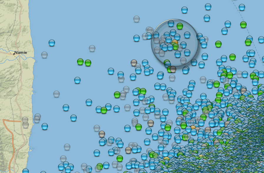
different fault?, same series? hard to say
I base this on the amount and location of aftershocks since the 5.7 2 days ago, and comparing with the previous aftershocks there.
NIED gave me 7 hours of data since the 5.7, will have to wait until tomorrow morning to get more
first image is the 7 hours of aftershocks since the 5.7
where it is in relation to the E off Fukushima series
where it is on the edge
different fault?, same series? hard to say
Public ID 2017p161601
Intensity severe
Universal Time March 1 2017, 19:01:02
NZ Daylight Time Thu, Mar 2 2017, 8:01:02 am
Depth 12 km
Magnitude 5.2226
Location 20 km south-west of Cheviot
Latitude, Longitude -42.96012 173.09491
www.geonet.org.nz...
1376 felt reports
there was an uptick in that southern part of the 7.8 aftershock series in the last few days.
As with Japan I hadn't logged them, too busy at work,up until today.
If the location is correct this is on a Fault that has previously been unaffected since the 7.8, only 3 quakes on the Blythe Fault since the 7.8
2.56-19/12/2016 14:35:28
2.65-25/01/2017 01:35:30
3.11-26/01/2017 19:59:41
this one about 12.33km south east of the the 5.69-22/11/2016 05:13:34
Intensity severe
Universal Time March 1 2017, 19:01:02
NZ Daylight Time Thu, Mar 2 2017, 8:01:02 am
Depth 12 km
Magnitude 5.2226
Location 20 km south-west of Cheviot
Latitude, Longitude -42.96012 173.09491
www.geonet.org.nz...
1376 felt reports
there was an uptick in that southern part of the 7.8 aftershock series in the last few days.
As with Japan I hadn't logged them, too busy at work,up until today.
edit on 03000000595917 by muzzy because: (no reason given)
If the location is correct this is on a Fault that has previously been unaffected since the 7.8, only 3 quakes on the Blythe Fault since the 7.8
2.56-19/12/2016 14:35:28
2.65-25/01/2017 01:35:30
3.11-26/01/2017 19:59:41
this one about 12.33km south east of the the 5.69-22/11/2016 05:13:34
edit on 03000000595917 by muzzy because: (no reason given)
further to: muzzy
where were the 15 x mag 5's and the Mainshock and the 6.2?
finger points to that last 5.7, one of the 3 x 5.7's
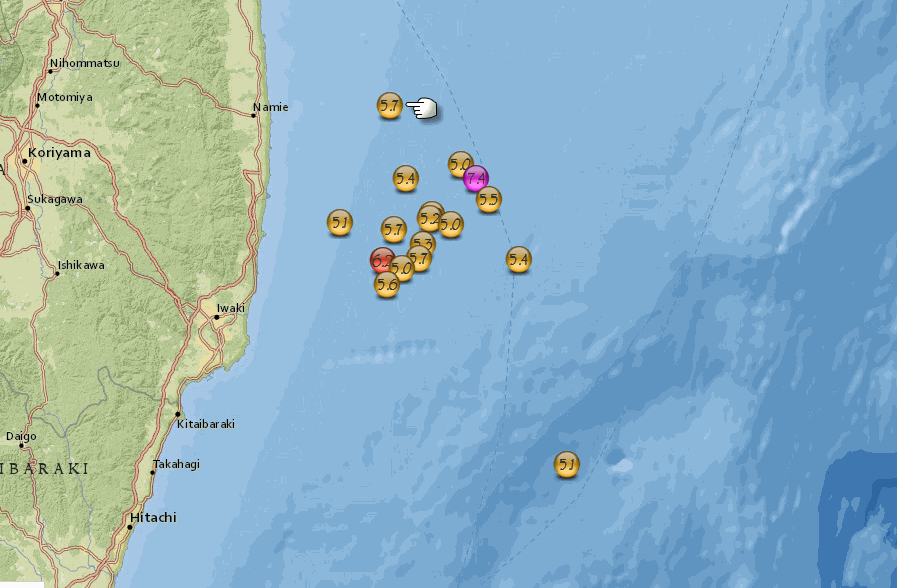
E off Fukushima page
where were the 15 x mag 5's and the Mainshock and the 6.2?
finger points to that last 5.7, one of the 3 x 5.7's
E off Fukushima page
edit on 03000000595917
by muzzy because: (no reason given)
new topics
-
University student disciplined after saying veganism is wrong and gender fluidity is stupid
Education and Media: 59 minutes ago -
Geddy Lee in Conversation with Alex Lifeson - My Effin’ Life
People: 2 hours ago -
God lived as a Devil Dog.
Short Stories: 2 hours ago -
Police clash with St George’s Day protesters at central London rally
Social Issues and Civil Unrest: 3 hours ago -
TLDR post about ATS and why I love it and hope we all stay together somewhere
General Chit Chat: 4 hours ago -
Hate makes for strange bedfellows
US Political Madness: 6 hours ago -
Who guards the guards
US Political Madness: 9 hours ago -
Has Tesla manipulated data logs to cover up auto pilot crash?
Automotive Discussion: 11 hours ago
top topics
-
Hate makes for strange bedfellows
US Political Madness: 6 hours ago, 14 flags -
Who guards the guards
US Political Madness: 9 hours ago, 13 flags -
whistleblower Captain Bill Uhouse on the Kingman UFO recovery
Aliens and UFOs: 16 hours ago, 11 flags -
Police clash with St George’s Day protesters at central London rally
Social Issues and Civil Unrest: 3 hours ago, 7 flags -
TLDR post about ATS and why I love it and hope we all stay together somewhere
General Chit Chat: 4 hours ago, 5 flags -
University student disciplined after saying veganism is wrong and gender fluidity is stupid
Education and Media: 59 minutes ago, 3 flags -
Has Tesla manipulated data logs to cover up auto pilot crash?
Automotive Discussion: 11 hours ago, 2 flags -
God lived as a Devil Dog.
Short Stories: 2 hours ago, 2 flags -
Geddy Lee in Conversation with Alex Lifeson - My Effin’ Life
People: 2 hours ago, 2 flags
active topics
-
Police clash with St George’s Day protesters at central London rally
Social Issues and Civil Unrest • 35 • : BedevereTheWise -
Thousands Of Young Ukrainian Men Trying To Flee The Country To Avoid Conscription And The War
Other Current Events • 119 • : FlyersFan -
Europe declares war on Russia?
World War Three • 65 • : Freeborn -
Candidate TRUMP Now Has Crazy Judge JUAN MERCHAN After Him - The Stormy Daniels Hush-Money Case.
Political Conspiracies • 731 • : Threadbarer -
"We're All Hamas" Heard at Columbia University Protests
Social Issues and Civil Unrest • 248 • : FlyersFan -
University student disciplined after saying veganism is wrong and gender fluidity is stupid
Education and Media • 4 • : chiefsmom -
-@TH3WH17ERABB17- -Q- ---TIME TO SHOW THE WORLD--- -Part- --44--
Dissecting Disinformation • 626 • : cherokeetroy -
The Superstition of Full Moons Filling Hospitals Turns Out To Be True!
Medical Issues & Conspiracies • 19 • : FloridaManMatty -
Iranian Regime Escalates Hiijab Mandate Through Sexual Violence and Beatings of Women
Mainstream News • 166 • : purplemer -
They Killed Dr. Who for Good
Rant • 67 • : grey580