It looks like you're using an Ad Blocker.
Please white-list or disable AboveTopSecret.com in your ad-blocking tool.
Thank you.
Some features of ATS will be disabled while you continue to use an ad-blocker.

Lesser Known Mysteries VI: The Enigmatic Dighton Rock — Evidence Of Pre-Columbian Contact?
page: 137
share:
I've decided to continue with the series of threads I started back in 2014 — Lesser Known Mysteries — a series of threads in which I
(hopefully) present folks with intriguing and unfamiliar subjects. As with earlier installments, I'd intended to write about three related subjects
but after starting to compose the OP, I decided it would be best to post this one by itself.
The Enigmatic Dighton Rock
In 1637, settlers from the Plymouth Colony purchased land from the Nemasket Indians in what is known as the Tetiquet Purchase — Tetiquet being the Nemaskets' name for the land. These settlers called their new home, Taunton, after the far away town in Somerset, England from which many of them had come.
Later, in 1672, a part of the purchase which would later become the town of Dighton, Massachusetts, was separated from Taunton and it was shortly after this that the earliest written record of the mysterious Dighton Rock would be recorded in 1680 by Rev. John Danforth.
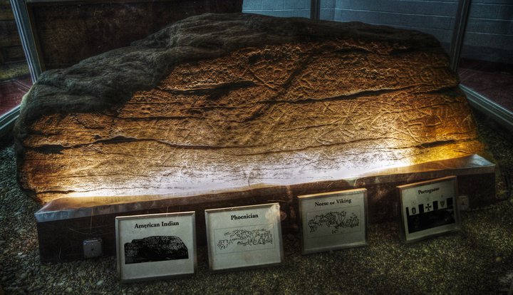
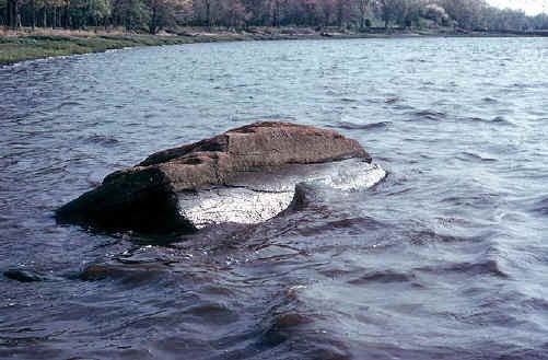
Until it was moved by the state in 1963 for preservation, the 11-foot long, 40-ton boulder sat in the shallows by the shores of the Taunton River where it narrowed near Dighton, its enigmatic inscriptions facing not toward the shore but rather the middle of the river where they would be conspicuous to passing boats. A description of the rock from Wikipedia:
Despite the description given by Cotton Mather in his 1690 book The Wonderful Works of God Commemorated — almost certainly based on second hand accounts and a healthy dose of imagination — regardless of their original characteristics, by the time of Danforth's drawing, the markings were relatively shallow with finer details discerned with some difficulty, possibly indicating a truly ancient date for the earliest carving. Further complicating matters, a few of the marks are the work of vandals. Along with the initials, there is one inscription noted in sources that appears to read, "Injun Trail to Spring in Swomp → yds. 167." (though it's not clear where these are on the rock from the sources).
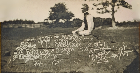
Unfortuately, as with many other petroglyphs popularized before the rise of modern archaeology, over the years the petroglyphs have been repeatedly painted or chalked to create contrast. While great for old photos, these sorts of alterations destroy valuable forensic information. Here we can see such treatment in a photograph of the eminent illustrator of Native American life and army officer, Seth Eastman, seated atop of the rock in 1853:
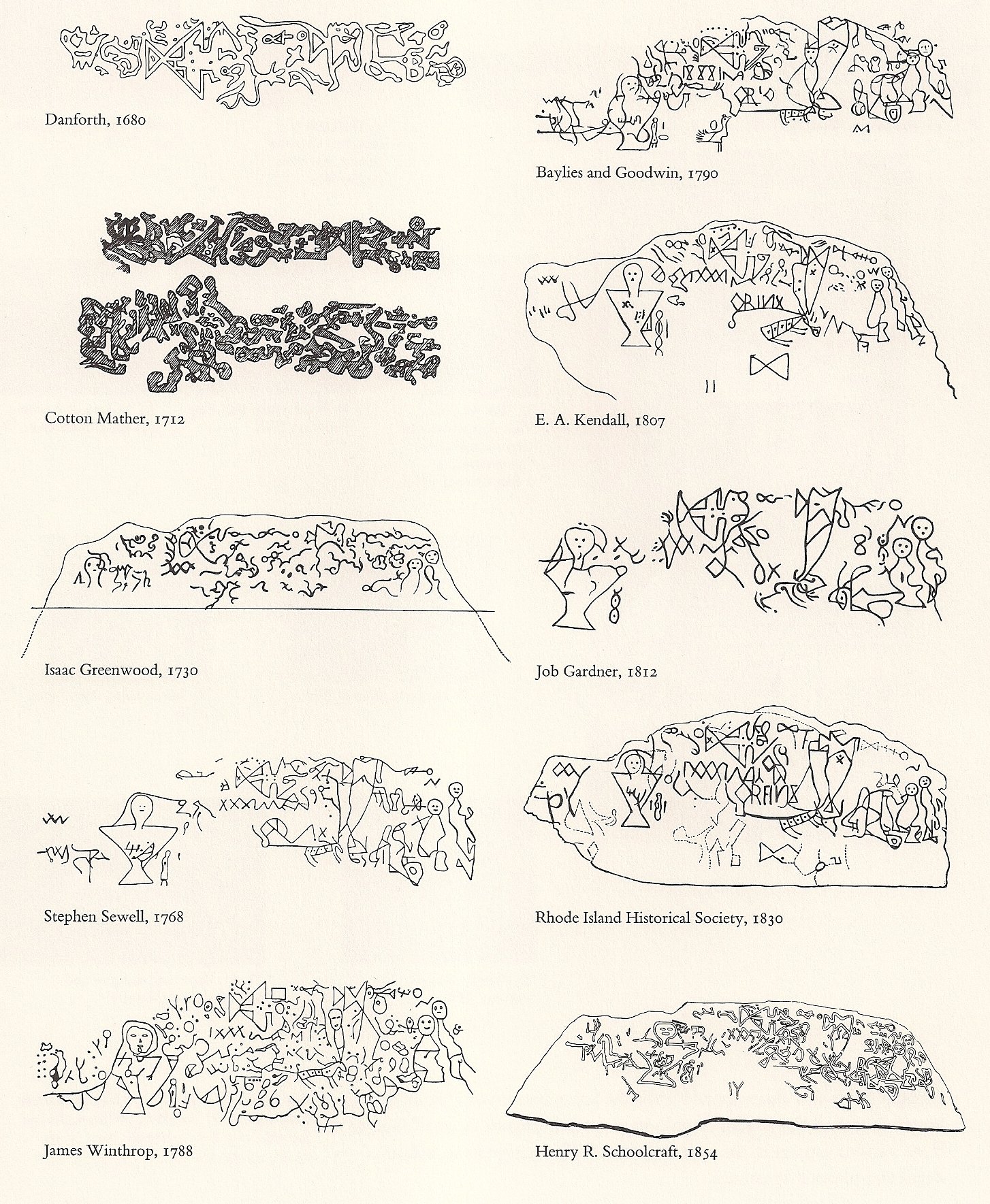
Along with the influences of confirmation bias in support of favored theories of origin, these factors explain the differing depictions of the petroglyps in the years since Danforth's. It also bears mention that Danforth appears to have only drawn those markings that were above the water line at the time he made his sketch. How much of the rock was visible at any point varied greatly with tide, season and year. The following is a collection of several depictions starting with Danforth's, which is preserved in the British Museum, and ending with one made in 1854. This image comes from Envisioning Information by Edward Tufte which draws from reproductions published in 1880 in the Annual report of the Bureau of Ethnology to the Secretary of the Smithsonian Institution (click here for the the image for the Smithsonian report):
 (fullsize image)
The rock now rests in a museum built for it in the 85-acre Dighton Rock State Park. Now that we've covered a bit of background, I'll go over some of the many theories that have been put forth over the years.
The Enigmatic Dighton Rock
In 1637, settlers from the Plymouth Colony purchased land from the Nemasket Indians in what is known as the Tetiquet Purchase — Tetiquet being the Nemaskets' name for the land. These settlers called their new home, Taunton, after the far away town in Somerset, England from which many of them had come.
Later, in 1672, a part of the purchase which would later become the town of Dighton, Massachusetts, was separated from Taunton and it was shortly after this that the earliest written record of the mysterious Dighton Rock would be recorded in 1680 by Rev. John Danforth.
Until it was moved by the state in 1963 for preservation, the 11-foot long, 40-ton boulder sat in the shallows by the shores of the Taunton River where it narrowed near Dighton, its enigmatic inscriptions facing not toward the shore but rather the middle of the river where they would be conspicuous to passing boats. A description of the rock from Wikipedia:
The boulder has the form of a slanted, six-sided block, approximately 5 feet (1.5 m) high, 9.5 feet (2.9 m) wide, and 11 feet (3.4 m) long. It is gray-brown crystalline sandstone of medium to coarse texture. The surface with the inscriptions has a trapezoidal face and is inclined 70 degrees to the northwest. It was found facing the water of the bay.
Despite the description given by Cotton Mather in his 1690 book The Wonderful Works of God Commemorated — almost certainly based on second hand accounts and a healthy dose of imagination — regardless of their original characteristics, by the time of Danforth's drawing, the markings were relatively shallow with finer details discerned with some difficulty, possibly indicating a truly ancient date for the earliest carving. Further complicating matters, a few of the marks are the work of vandals. Along with the initials, there is one inscription noted in sources that appears to read, "Injun Trail to Spring in Swomp → yds. 167." (though it's not clear where these are on the rock from the sources).
Unfortuately, as with many other petroglyphs popularized before the rise of modern archaeology, over the years the petroglyphs have been repeatedly painted or chalked to create contrast. While great for old photos, these sorts of alterations destroy valuable forensic information. Here we can see such treatment in a photograph of the eminent illustrator of Native American life and army officer, Seth Eastman, seated atop of the rock in 1853:
Along with the influences of confirmation bias in support of favored theories of origin, these factors explain the differing depictions of the petroglyps in the years since Danforth's. It also bears mention that Danforth appears to have only drawn those markings that were above the water line at the time he made his sketch. How much of the rock was visible at any point varied greatly with tide, season and year. The following is a collection of several depictions starting with Danforth's, which is preserved in the British Museum, and ending with one made in 1854. This image comes from Envisioning Information by Edward Tufte which draws from reproductions published in 1880 in the Annual report of the Bureau of Ethnology to the Secretary of the Smithsonian Institution (click here for the the image for the Smithsonian report):
The rock now rests in a museum built for it in the 85-acre Dighton Rock State Park. Now that we've covered a bit of background, I'll go over some of the many theories that have been put forth over the years.
edit on 2016-11-19 by theantediluvian because: (no reason given)
The Theories
When it comes to questions about the origins of the Dighton Rock petroglyphs, there are very nearly as many theories as individual glyphs. Danforth himself, in the brief description that accompanied his sketch, stated his opinion that Native Americans had been responsible for the carvings. This is the the most obvious and probable answer and one later echoed in 1789 by George Washington who found them reminiscent of Native American drawings he'd seen in Virginia.
Others have put forth far more sensational theories.
One of the earliest comes from a 1689 sermon from the Puritan minister Cotton Mather who posited that the carvings were possibly the work of a much earlier group of European settlers who'd been inspired by none other than Satan himself to cross the Atlantic, presumably dying horrible deaths thereafter.
A few others from an article by the New England Historical Society:
The Chalres Chrisitian Rafn theory or Norse origins is discussed in some detail in a 1958 article republished on the web by American Heritage. Other theories briefly described in the same:
Unfortunately for Rafn's theory, extensive work by Professor Edmund B. Delabarre, a professor of psychology at Brown University who'd purchased a home a mere mile from the rock and studied it for more than thirty years, greatly discredited Rafn's own research.
Delabarre's own theory, publshed in 1912, was that the petroglyphs had been made by Portugese explorer Miguel Corte-Real, who'd gone missing in 1501 and was presumed lost at sea. According to Delabarre, the Dighton Rock contains a rendition of the Portugese coat of arms and abbreviated Latin that translates to:
I, Miguel Cortereal, 1511. In this place, by the will of God, I became a chief of the Indians.
A more recent theory comes from retired British naval officer and submariner, Gavin Menzies, who posited a Chinese origin in his 2002 bestseller, 1421: The Year China Discovered America.
I for one am in the camp with Danforth, Washington and the preponderance of mainstream archaeological opinion on this one but the prospects of an alternative origin are always intriguing.
Image sources:
Dighton Rock in museum
Dighton Rock surrounded by waters of the Taunton River
Seth Eastman atop Dighton Rock
Inscriptions compiled for Edward Tufte's book
When it comes to questions about the origins of the Dighton Rock petroglyphs, there are very nearly as many theories as individual glyphs. Danforth himself, in the brief description that accompanied his sketch, stated his opinion that Native Americans had been responsible for the carvings. This is the the most obvious and probable answer and one later echoed in 1789 by George Washington who found them reminiscent of Native American drawings he'd seen in Virginia.
Others have put forth far more sensational theories.
One of the earliest comes from a 1689 sermon from the Puritan minister Cotton Mather who posited that the carvings were possibly the work of a much earlier group of European settlers who'd been inspired by none other than Satan himself to cross the Atlantic, presumably dying horrible deaths thereafter.
A few others from an article by the New England Historical Society:
In 1767, Ezra Stiles, then president of Yale, declared that the figures on the rock were Phoenician – theorizing that the Phoenicians – mainly known for their sea-faring trade in the Mediterranean – had managed a visit to North America and left the writing as a calling card.
That idea gained traction in Europe, as well, where Danforth’s drawing was receiving fresh attention among British and French historians. Others concluded the markings were from Armenians who made their way to America via Siberia. And another camp, which had been trying to connect the origins of Native American tribes with Asia, proposed that the characters were from explorers from Japan, China or other parts of Asia.
In 1837, the controversy was reignited when Danish writer Charles Christian Rafn published his Antiquities Americanae, which contained more than 40 pages of analysis of the Dighton Rock. Rafn concluded the markings on the rock were Norse, and found in the writing the inscription: “Thorfinn and his 151 companions took possession of this land.”
The Chalres Chrisitian Rafn theory or Norse origins is discussed in some detail in a 1958 article republished on the web by American Heritage. Other theories briefly described in the same:
In 1781 Count Antoine Court de Gebelin of Paris announced that he had fathomed the secret. Dighton Rock commemorated the visit to Massachusetts “in very ancient times” of a shipload of seamen from Carthage, who lived for a while on Mount Hope Bay and established friendly relations with the Indians there. The drawings on the rock, De Gebelin explained, portray the leaders of the expedition consulting an oracle in order to select an auspicious moment for the perilous voyage back to Carthage.
In 1807 Samuel Harris, Jr., a Harvard scholar, declared that he was able to decipher on the face of the rock three ancient Hebrew words in Phoenician letters: “king,” “priest,” and “idol.”
In 1831 Ira Hill, a Maryland schoolteacher, concluded that the rock was engraved in the second month of the tenth year of the reign of King Solomon by an expedition of Tyrians and Jews such as the one described in the Old Testament, I Kings 9:
And king Solomon made a navy of ships in Eziongeber… And Hiram sent in the navy his servants, shipmen that had knowledge of the sea, with the servants of Solomon. And they came to Ophir, and fetched from thence gold, four hundred and twenty talents, and brought it to king Solomon.
The drawings on the rock, Hill firmly believed, mapped in detail the voyage from the eastern Mediterranean through the Pillars of Hercules, past the Canary Islands, and on across the Atlantic to Assonet Neck.
Unfortunately for Rafn's theory, extensive work by Professor Edmund B. Delabarre, a professor of psychology at Brown University who'd purchased a home a mere mile from the rock and studied it for more than thirty years, greatly discredited Rafn's own research.
Delabarre's own theory, publshed in 1912, was that the petroglyphs had been made by Portugese explorer Miguel Corte-Real, who'd gone missing in 1501 and was presumed lost at sea. According to Delabarre, the Dighton Rock contains a rendition of the Portugese coat of arms and abbreviated Latin that translates to:
I, Miguel Cortereal, 1511. In this place, by the will of God, I became a chief of the Indians.
A more recent theory comes from retired British naval officer and submariner, Gavin Menzies, who posited a Chinese origin in his 2002 bestseller, 1421: The Year China Discovered America.
I for one am in the camp with Danforth, Washington and the preponderance of mainstream archaeological opinion on this one but the prospects of an alternative origin are always intriguing.
Image sources:
Dighton Rock in museum
Dighton Rock surrounded by waters of the Taunton River
Seth Eastman atop Dighton Rock
Inscriptions compiled for Edward Tufte's book
Other installments in this series:
Lesser Known Mysteries: Mysterious People
Lesser Known Mysteries: Enigmatic Inscriptions
Lesser Known Mysteries: Unexplained Artifacts
Lesser Known Mysteries IV: Strange Seas
Lesser Known Mysteries V: Disturbing Disappearances
Other threads you might find interesting:
When the Devil Came to Widecombe-in-the-Moor
Simon Magus, Mug Ruith, Tlachtga, a Flying Machine and the Earliest Samhain Bonfire?
Cappella Sansevero's Macabre and Mysterious Anatomical Machines
New OOPArts? Kaolin 'Grenade' Unearthed by Ground Hog in Eastern Pennsylvania
Recent threads:
The 200 Year-Old Mystery of the Grave of the Female Stranger
Medieval Cursed Well of Cult of Saint Anne Excavated
a reply to: theantediluvian
Really cool stuff.
Not sure what to make of it just yet. But I love these things.
Thanks for sharing
Really cool stuff.
Not sure what to make of it just yet. But I love these things.
Thanks for sharing
a reply to: theantediluvian
Starred and Flagged! Honestly, looking at the first drawing from 1600s, my first thought was that it looked more map like than glyphics. A quick satellite google search on the Taunton river confirmed my idea. It is amazing by zooming in and out one sees a very similar pictograph of the waterways and lakes further inland. Doesn't say who created this map, but I have to believe that the later drawings were added later.
Starred and Flagged! Honestly, looking at the first drawing from 1600s, my first thought was that it looked more map like than glyphics. A quick satellite google search on the Taunton river confirmed my idea. It is amazing by zooming in and out one sees a very similar pictograph of the waterways and lakes further inland. Doesn't say who created this map, but I have to believe that the later drawings were added later.
Im glad the old antideluvian is back!
That other guy was boring!!
It's remarkable, really... after the election was over, it's like a switch was flipped and you went back to normal again. I don't know at what point you "switched" into "mr. political", I just noticed it eventually. Anyway, glad to have you back!
Thanks for sharing bud!
That other guy was boring!!
It's remarkable, really... after the election was over, it's like a switch was flipped and you went back to normal again. I don't know at what point you "switched" into "mr. political", I just noticed it eventually. Anyway, glad to have you back!
Thanks for sharing bud!
Fantastic thread and story, I've saved the page to read later.
a reply to: theantediluvian
You are a Credit to ATS my friend.
I go thru Dighton many times on my surfing trips to RI and have always wanted to stop and see it. My girlfriend and I, many years ago made an attempt but I think it was closed at the time.
This is inside "The Bridgewater Triangle" an area in Massachusetts known for Paranormal Activity. I have spent some time around there, mostly on my dirt bike in the Freetown State Forest, more than a couple times I have felt un-easy. I met a strange toothless guy that told me he wanders the forest, and found a campfire still burning at a dilapidated shack miles from anywhere and nobody around.
I have also visited Antwan Rock is named for Chief Anawan and is the site where Chief Anawan surrendered to the colonists, ending "King Phillip's War". Legend says that the angry spirits of Chief Anawan's warriors continue to haunt the area, starting spectral fires and "ghost dancing".
wiki
a reply to: theantediluvian
So is it possible this rock was used as a mooring stone to anchor sailing vessels? I've seen some other stones like this with glyphs even. Imagine a sailing vessel tied up off shore. Its got an anchor but storms require stronger moorings. Being its an exploration vessel before regular harbors and docks, any heavy stone in the right position could be utilized. Some moorings were covered with glyphs, maybe they were blessings (or instructions).
Dunno... did an image search.
a reply to: CynConcepts
a reply to: intrptr
There's clear evidence of a tradition of petroglyphs being carved into large boulders or more often out West, rock panels, located by or in bodies of water, particularly rivers, in a variety of locations in the US.
Just a few out of dozens:
Indian God Rock - Allegheny River, PA
Big Indian Rock & Little Indian Rock - Susquehanna River, PA
Eel River petroglyphs - Trinity County, CA
Horsethief Lake petroglyphs - Horsethief Lake/next to Columbia River in Washington (right on border with Oregon)
There's probably 8-9 of them of various size in Pennsylvania alone. What makes Dighton Rock intriguing in my opinion is that most (but not all of course) other instances, the glyps are recognizable as animals/humans/humanoid hybrids/etc and then along side them are shapes like spirals, wheels, etc. I guess it's that the Dighton Rock glyphs look less like art and more like an attempt to convey some complex message. Of course, for all I know, they're prehistoric tags from rock carving taggers.
I think it's clear from the location from many of these that they are for public consumption and in that way, I see them as being more like billboards along the highway. Though it's interesting that in a number of cases that the local tribes attributed some religious significance even if the members couldn't/can't "decipher" the glyphs. This isn't purely a contemporary phenomenon, the Indian God Rock was described as early as 1749. Some of these sites are thought to predate European contact by hundreds of years though so the tribes living in the area may not have been the ones to originate them or their meanings could have simply been lost to time.
Of course just because they have things in common doesn't mean that there is a similar function among all these disparate groups that created them. After all, you can travel down the roads today and you'll see billboards, road signs, memorials, shrines, etc.
edit on 2016-11-19 by
theantediluvian because: (no reason given)
a reply to: 3n19m470
a reply to: Arnie123
Lol. I'm still the same snarky liberal progressive I've always been but the election is over and inauguration is two months away. Given the appointments thus far, I'm all the more certain there will be plenty to be said. Right now, I'm mulling things over and indulging some other interests.
a reply to: theantediluvian
Wow - great thread!
I've just spent hours reading (and further researching) your first 2 installments and am looking forward to reading reading installments IV & V.
Bravo!
Wow - great thread!
I've just spent hours reading (and further researching) your first 2 installments and am looking forward to reading reading installments IV & V.
Bravo!
As you point out, the one thing that discredits the indian hypothesis is that its the only example of text I have ever seen. The carvings are
symbolic, and totally unlike anything else on the continent, so far as I can tell.
Fantastic thread.
Fantastic thread.
new topics
-
University of Texas Instantly Shuts Down Anti Israel Protests
Education and Media: 56 minutes ago -
Any one suspicious of fever promotions events, major investor Goldman Sachs card only.
The Gray Area: 3 hours ago -
God's Righteousness is Greater than Our Wrath
Religion, Faith, And Theology: 7 hours ago -
Electrical tricks for saving money
Education and Media: 10 hours ago -
VP's Secret Service agent brawls with other agents at Andrews
Mainstream News: 11 hours ago
top topics
-
VP's Secret Service agent brawls with other agents at Andrews
Mainstream News: 11 hours ago, 10 flags -
Cats Used as Live Bait to Train Ferocious Pitbulls in Illegal NYC Dogfighting
Social Issues and Civil Unrest: 16 hours ago, 8 flags -
Nearly 70% Of Americans Want Talks To End War In Ukraine
Political Issues: 12 hours ago, 4 flags -
Electrical tricks for saving money
Education and Media: 10 hours ago, 4 flags -
Sunak spinning the sickness figures
Other Current Events: 12 hours ago, 3 flags -
Late Night with the Devil - a really good unusual modern horror film.
Movies: 14 hours ago, 2 flags -
Any one suspicious of fever promotions events, major investor Goldman Sachs card only.
The Gray Area: 3 hours ago, 2 flags -
The Good News According to Jesus - Episode 1
Religion, Faith, And Theology: 17 hours ago, 1 flags -
God's Righteousness is Greater than Our Wrath
Religion, Faith, And Theology: 7 hours ago, 0 flags -
University of Texas Instantly Shuts Down Anti Israel Protests
Education and Media: 56 minutes ago, 0 flags
active topics
-
Nearly 70% Of Americans Want Talks To End War In Ukraine
Political Issues • 32 • : andy06shake -
Any one suspicious of fever promotions events, major investor Goldman Sachs card only.
The Gray Area • 6 • : ImagoDei -
University of Texas Instantly Shuts Down Anti Israel Protests
Education and Media • 1 • : PorkChop96 -
Sunak spinning the sickness figures
Other Current Events • 10 • : crayzeed -
Reason of the Existence
The Gray Area • 20 • : belkide -
Black mirror, what happened.
Television • 20 • : seekshelter -
God's Righteousness is Greater than Our Wrath
Religion, Faith, And Theology • 25 • : andy06shake -
Russia Ukraine Update Thread - part 3
World War Three • 5730 • : Arbitrageur -
VP's Secret Service agent brawls with other agents at Andrews
Mainstream News • 43 • : Hakaiju -
Everest-sized ‘Devil comet’ Pons-Brooks Visible Now
Space Exploration • 17 • : Compendium
37