It looks like you're using an Ad Blocker.
Please white-list or disable AboveTopSecret.com in your ad-blocking tool.
Thank you.
Some features of ATS will be disabled while you continue to use an ad-blocker.

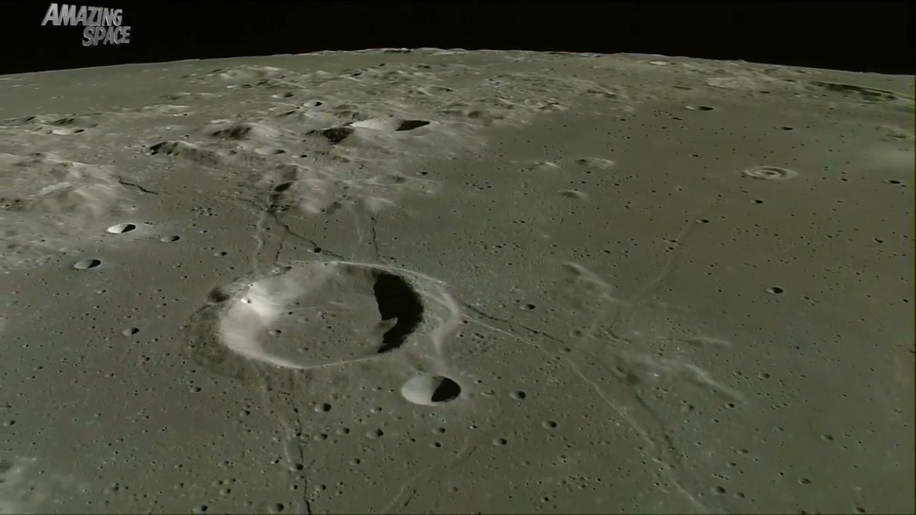
The Moon - Incredible Lunar Views From The Japanese SELENE Orbiter - Earthrise
page: 2share:


a reply to: Saint Exupery
Great to know, thank you as well. Heading there now to see what else I can create!
Great to know, thank you as well. Heading there now to see what else I can create!
a reply to: TheKnightofDoom
Bump map garbage.
ALL CGI.
I just don't believe "them".
Bump map garbage.
ALL CGI.
I just don't believe "them".
edit on 1-11-2016 by MagicCow because: Thank you for posting OP. One day maybe we'll see the real thing.
I can guarantee its already been done a thousand times by others, but if any of you want your own file of a certain lat and long on the moon let me
know and I can make a model for you.
I can even put it in a format so you can view it in VR.
I can even put it in a format so you can view it in VR.
a reply to: OneBigMonkeyToo
a reply to:Saint Exupery
Any idea where I can find photos with DEM data or EXIF data of the moon?
Then I can properly scale the model and have the actual coordinates,
a reply to:Saint Exupery
Any idea where I can find photos with DEM data or EXIF data of the moon?
Then I can properly scale the model and have the actual coordinates,
a reply to: OneBigMonkeyToo
Just went there and now downloading a 288 mb tif image that I can use the DEM and DSM data from!
Just went there and now downloading a 288 mb tif image that I can use the DEM and DSM data from!
a reply to: Crumbles
It most likely is.
They take hi res pictures, and do the same thing I did with the images - use Photogrammetry to make a 3d model.
Then afters its all compiled together they texturize it from the pictures and create a DTM - Digital Terrain Model.
Once thats been processed the software that generates the model can be used to make a fly through.
a reply to: MagicCow
What did the Japanese do?
Thing is, and I know this from years of looking at lunar images from every space agency that has been there, I have never found a single contradiction in any of them, be they the US, USSR, China, Japan, India, ESA, anyone with a decent astronomical telescope, you name it.
By saying "I don't trust 'them' ", you pretty much have to say "I don't trust any of them".
a reply to: OneBigMonkeyToo
Monkey.
I don't trust ANY OF THEM.
The lie is just too big.
That's why almost every space agency on this planet all use the vector symbol on their
space agency logos. Has nothing to do with creating the easiest representation of a plane or shuttle and aerospace vehicle.
It has everything to do with shared symbolism for shared groups of power within that sphere.
I don't trust ANY OF THEM.
a reply to: TheKnightofDoom
The full HD image data set may only have just been released, but lots of it has been on the web for a while. The Earthrise video in the OP, for example, has been out there since it was taken in 2008 eg
as have many other videos from them. You can also buy the book of the film:
www.amazon.co.uk...
which has been out since 2011.
I'd also point out that the HDTV images are nothing like as high resolution as the still images they took, and which have also been online since at least 2010.
edit on 1/11/2016 by OneBigMonkeyToo because: additional info
a reply to: OneBigMonkeyToo
I don't ignore the world of science.
I love science - even what little of it I truly understand.
They however lie to us about EVERYTHING.
I don't think we get a "pass" on this one.
I don't ignore the world of science.
I love science - even what little of it I truly understand.
They however lie to us about EVERYTHING.
I don't think we get a "pass" on this one.
a reply to: OneBigMonkeyToo
Thank you, is is amazing to see all the creators on the moon. Lucky for us we have a atmosphere to help burn up small pieces of space rock.
Thank you, is is amazing to see all the creators on the moon. Lucky for us we have a atmosphere to help burn up small pieces of space rock.
so here on earth satellites in similarly distance orbits can produce unimaginable details of earth in pictures taken from space, succesfully mapping
the entire earth for gps satellite. similarly, with a dslr 4k cam and a high powered telescope, we can produce the same details of the moon in images
from that probe here on earth, despite air and light pollution. we can now see the moon upclose from our back yard, and yet, a probe at close
proximity to the moon, with no air or light pollution or atmosphere and with a non fluctuating light source still can only give blurry images of the
moon its orbiting.
i find it strange that we have cameras which can see the rings of saturn or the eye of jupiter but this is on par to our best moon videography.... we have more high rez images of neptune and jupiter or saturn than the moon...
i find it strange that we have cameras which can see the rings of saturn or the eye of jupiter but this is on par to our best moon videography.... we have more high rez images of neptune and jupiter or saturn than the moon...
a reply to: odzeandennz
It is not the best imagery of the moon, it is from one of the imaging instruments carried by Kaguya, not the best one. If you follow the links I posted earlier you will find images of much higher resolution. Terrestrial satellites are better than the lunar ones because it is cheaper to get them in orbit around Earth but you are also being fooled by the lack of identifiable features like buildings to judge scale.
Based on my experience of looking at them a lot, the best images by far are the LRO images. Not far behind that are some of the Lunar Orbiter images. After that comes the Apollo Panoramic Camera images (taken with what was then the best spy satellite camera), then India, then Japan's still images, then China.
You will have to buy a very expensive telescope to get anywhere near the level of detail in any of those, and no, we do not have higher resolution images of the outer planets than we do our moon.
edit on 1/11/2016 by OneBigMonkeyToo because: (no reason given)
new topics
-
Food poisoning last night
Health & Wellness: 39 minutes ago -
hello from SurfsideT
Introductions: 42 minutes ago -
Glass of Time…Time2024 writer
Short Stories: 1 hours ago -
Democrats Introduce Bill That Will Take Away Donald Trumps Secret Service Protection
2024 Elections: 1 hours ago -
Planned Parenthood Targets Black Neighborhoods
Social Issues and Civil Unrest: 2 hours ago -
Who could it beeee now?
New World Order: 5 hours ago -
The Russian Vostok complex has been put into operation in Antarctica
Science & Technology: 6 hours ago -
Letitia James tells judge to Reject Trumps $175 Million Bond
2024 Elections: 6 hours ago -
Tucker Carlson UFOs are piloted by spiritual entities with bases under the ocean and the ground
Aliens and UFOs: 6 hours ago -
Hello from burritocat
Introductions: 8 hours ago
top topics
-
The Russian Vostok complex has been put into operation in Antarctica
Science & Technology: 6 hours ago, 13 flags -
Michigan school district cancels lesson on gender identity and pronouns after backlash
Education and Media: 16 hours ago, 11 flags -
Letitia James tells judge to Reject Trumps $175 Million Bond
2024 Elections: 6 hours ago, 11 flags -
Remember These Attacks When President Trump 2.0 Retribution-Justice Commences.
2024 Elections: 11 hours ago, 9 flags -
WF Killer Patents & Secret Science Vol. 1 | Free Energy & Anti-Gravity Cover-Ups
General Conspiracies: 14 hours ago, 8 flags -
Democrats Introduce Bill That Will Take Away Donald Trumps Secret Service Protection
2024 Elections: 1 hours ago, 6 flags -
Who could it beeee now?
New World Order: 5 hours ago, 6 flags -
Israel attacking Iran again.
Middle East Issues: 16 hours ago, 5 flags -
Hello from burritocat
Introductions: 8 hours ago, 4 flags -
Planned Parenthood Targets Black Neighborhoods
Social Issues and Civil Unrest: 2 hours ago, 4 flags
active topics
-
Letitia James tells judge to Reject Trumps $175 Million Bond
2024 Elections • 17 • : WeMustCare -
"We're All Hamas" Heard at Columbia University Protests
Social Issues and Civil Unrest • 139 • : marg6043 -
Candidate TRUMP Now Has Crazy Judge JUAN MERCHAN After Him - The Stormy Daniels Hush-Money Case.
Political Conspiracies • 415 • : Oldcarpy2 -
Democrats Introduce Bill That Will Take Away Donald Trumps Secret Service Protection
2024 Elections • 26 • : WeMustCare -
Food poisoning last night
Health & Wellness • 6 • : ScarletDarkness -
BUCKLE UP--Iranian Attack on Israel Imminent--US Officials Warn
Mainstream News • 208 • : WeMustCare -
Who could it beeee now?
New World Order • 23 • : xuenchen -
Man sets himself on fire outside Donald Trump trial
Mainstream News • 51 • : andy06shake -
A man of the people
Medical Issues & Conspiracies • 18 • : angelchemuel -
Truth Social goes public, be careful not to lose your money
Mainstream News • 121 • : matafuchs