It looks like you're using an Ad Blocker.
Please white-list or disable AboveTopSecret.com in your ad-blocking tool.
Thank you.
Some features of ATS will be disabled while you continue to use an ad-blocker.

Google Earth - Antarctica Oddities on New Layer? (bottom half reposted from New User forum)
page: 3share:
a reply to: IQPREREQUISITE
I guess it's not a very interesting thread? It's too bad, I was looking forward to learning more about mapping issues that continue.
Notice that antarctica has returned to pixillating virtually everything south of 80 degrees lattitude?
The newest Google Earth now has a time line feature but it doesn't work. Meaning, you cannot go back and find previous images that used to be there and are now gone. Though you can see where the old tiles were (frames around the area where the tiles used to be)- they just aren't there for us to view any longer.
Not sure what it is, but I remain puzzled and frustrated.
I took a low resolution snapshot of an old map of the anarctic circle (from the 2002 National Geographic Magazine).
This is what I got with my 4 year old Samsung Galaxy 4 crappy camera phone.
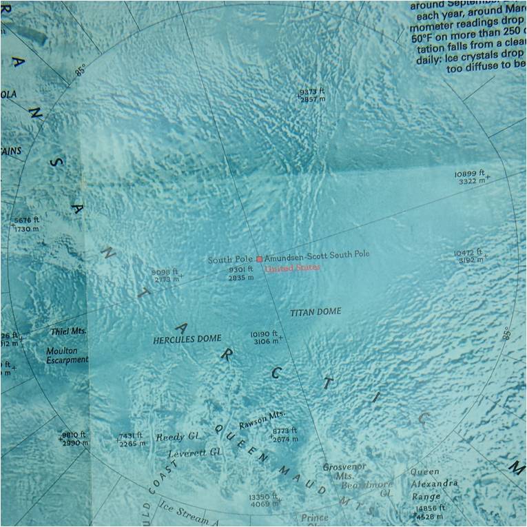
That's a picture of a picture from a 15 year old magazine I took on a 4 year old camera phone - LOL!
Compare that to google maps, who goes to the ends of the earth to make sure they get the highest quality images for their mapping software!
They will even use kites if they have to (they claim in their online adds)
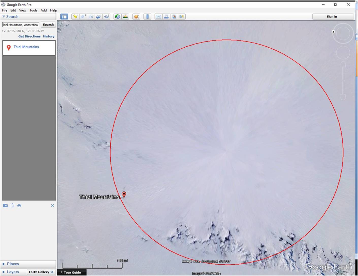
This is the enrapturing image captured by our multibillion dollar science projects on penguins and rocks that is currently up on google (Thiel Mountains label for reference).
Also, as I'm able to post again, here are my questions from the last post on this thread:
ANTARCTICA MAPPING QUESTIONS
1) Where have you found accurate data (current-day-technology, 50m DEM or better res) combining high resolution image overlay's with topographic data for Antarctica. Any time period. Any part of the continent?
2) What limitations (technological limitations or otherwise) would prevent us from accessing any of this information?
3) Do publicly available mapping/imaging tools (like google earth/google maps) contain pixilated or otherwise altered data sets of any part of the antarctic continent, over any time period?
4) Are data/images which were previously accessible over any time period ever removed, replaced, or altered?
5) Can the previously available images be retrieved? The Historical Imagery tool on Google Earth helps to maintain data integrity over time. Have you found anomalies in the data set over time?
6) Where else (coordinates on Antarctica or otherwise) have others seen oddities related to imaging issues crop up (like the google moon thread...)? I know there are endless videos of this stuff on youtube, I'm curious about the pixillation or smear techniques to compare to the way its done here to see similarities. I love patterns and puzzles!
7) What do you think of the stated strategy of the combat support agency (NGA)? Take a look at what they say about providing transparent mapping data within the public domain:
www.nga.mil...
Specifically, the statements:
“we will take calculated risk and learn and adapt as the realities of the world dictate.”
“We welcome and embrace (emerging information) sources as we continue to leverage exquisite and specialized classified sources. Our environment grows more transparent and more connected by the day. Our customers will access our geospatial service as seamlessly on the World Wide Web as on our classified networks. We will integrate geospatial intelligence within the context of all sources to resolve intelligence questions."
Specifically, consider the NGA’s position in light of the spirit that the Antarctic Treaty System (ATS) is written in?
Is the strategy of the NGA consistent with the ATS?
en.wikipedia.org...
Who are the military's "customers"?
Thank you!
I guess it's not a very interesting thread? It's too bad, I was looking forward to learning more about mapping issues that continue.
Notice that antarctica has returned to pixillating virtually everything south of 80 degrees lattitude?
The newest Google Earth now has a time line feature but it doesn't work. Meaning, you cannot go back and find previous images that used to be there and are now gone. Though you can see where the old tiles were (frames around the area where the tiles used to be)- they just aren't there for us to view any longer.
Not sure what it is, but I remain puzzled and frustrated.
I took a low resolution snapshot of an old map of the anarctic circle (from the 2002 National Geographic Magazine).
This is what I got with my 4 year old Samsung Galaxy 4 crappy camera phone.
That's a picture of a picture from a 15 year old magazine I took on a 4 year old camera phone - LOL!
Compare that to google maps, who goes to the ends of the earth to make sure they get the highest quality images for their mapping software!
They will even use kites if they have to (they claim in their online adds)
This is the enrapturing image captured by our multibillion dollar science projects on penguins and rocks that is currently up on google (Thiel Mountains label for reference).
Also, as I'm able to post again, here are my questions from the last post on this thread:
ANTARCTICA MAPPING QUESTIONS
1) Where have you found accurate data (current-day-technology, 50m DEM or better res) combining high resolution image overlay's with topographic data for Antarctica. Any time period. Any part of the continent?
2) What limitations (technological limitations or otherwise) would prevent us from accessing any of this information?
3) Do publicly available mapping/imaging tools (like google earth/google maps) contain pixilated or otherwise altered data sets of any part of the antarctic continent, over any time period?
4) Are data/images which were previously accessible over any time period ever removed, replaced, or altered?
5) Can the previously available images be retrieved? The Historical Imagery tool on Google Earth helps to maintain data integrity over time. Have you found anomalies in the data set over time?
6) Where else (coordinates on Antarctica or otherwise) have others seen oddities related to imaging issues crop up (like the google moon thread...)? I know there are endless videos of this stuff on youtube, I'm curious about the pixillation or smear techniques to compare to the way its done here to see similarities. I love patterns and puzzles!
7) What do you think of the stated strategy of the combat support agency (NGA)? Take a look at what they say about providing transparent mapping data within the public domain:
www.nga.mil...
Specifically, the statements:
“we will take calculated risk and learn and adapt as the realities of the world dictate.”
“We welcome and embrace (emerging information) sources as we continue to leverage exquisite and specialized classified sources. Our environment grows more transparent and more connected by the day. Our customers will access our geospatial service as seamlessly on the World Wide Web as on our classified networks. We will integrate geospatial intelligence within the context of all sources to resolve intelligence questions."
Specifically, consider the NGA’s position in light of the spirit that the Antarctic Treaty System (ATS) is written in?
Is the strategy of the NGA consistent with the ATS?
en.wikipedia.org...
Who are the military's "customers"?
Thank you!
edit on 17-10-2016 by androal because: (no reason given)
a reply to: androal
Actually you have an interesting thread and raised some very valid questions. I forget but there's another thread like this one where the OP is also questioning the clarity and accuracy of the images. And from what I gather from reading topics like this one it's either of two things:
1. It's classified. So they deliberately smear/smudge/censor/down res some of the images since some parts of the north and south are militarized.
2. Hardware and software anomalies. Apparently they are not high tech enough as most of us were led to believe or thought.
My own theory is that, they have an accurate and high resolution version of Google Earth...what we have is the consumer version hence we have "limited" access to the images.
a reply to: IQPREREQUISITE
Yeah, totally agree. The anomolies are software glitches. I think I kinda said that... but they're fun to play with!
The issue of making the public data accessible is the bug up my butt. And it sorta pisses me off that the military has a need to hide something in Antarctica. I saw a video with he NGA director Robert Cardillo talking about transparency of data to the public. He seems to be a decent guy. He doesn't come across as contrived.
www.youtube.com...
In the video he specifically mentions the transparency issue in Antarctica and also gives a plausable case for the reason why. Basically, it comes down to a culture issue with the old-timers hanging onto old ideas. I think Snowden freaked them out pretty good, and the stodgy old guys aren't going to be able to catch up. I suspect we'll have our data eventually... I'm impatient. And there is some spectacular stuff out there:
www.planet.com...
www.digitalglobe.com...
www.satimagingcorp.com...
I'm salivating to get the topo imagery. I'm going to Hawaii next year to summit Mauna Kea on a recumbent trike.
Those companies get to profit from our tax dollars. I'd rather they do it anyways because the govt seems to screw up anything they touch (embezzle it away...)
This is what I'm about: www.youtube.com... The ultimate expedition. Ride to the south pole!!!! She did it by the way!
www.whiteicecycle.com...
I want to be the first disabled person to do it. Just a dream... I need some maps man!!!
Maybe I can get the NGA to sponsor me!
edit on 18-10-2016 by androal because: (no reason given)
a reply to: androal
Above 12k the O2 situation can be a problem for some but the road is usually in pretty good shape. It's graded regularly.
The switchback pitch above Halepohaku is going to be the toughest part. It's steep and long.
magis.manoa.hawaii.edu...
I'm going to Hawaii next year to summit Mauna Kea on a recumbent trike.
Above 12k the O2 situation can be a problem for some but the road is usually in pretty good shape. It's graded regularly.
The switchback pitch above Halepohaku is going to be the toughest part. It's steep and long.
I gave you the link previously.
Just a dream... I need some maps man!!!
magis.manoa.hawaii.edu...
edit on 10/19/2016 by Phage because: (no reason given)
new topics
-
When an Angel gets his or her wings
Religion, Faith, And Theology: 25 minutes ago -
Comparing the theology of Paul and Hebrews
Religion, Faith, And Theology: 1 hours ago -
Pentagon acknowledges secret UFO project, the Kona Blue program | Vargas Reports
Aliens and UFOs: 2 hours ago -
Boston Dynamics say Farewell to Atlas
Science & Technology: 2 hours ago -
I hate dreaming
Rant: 3 hours ago -
Man sets himself on fire outside Donald Trump trial
Mainstream News: 4 hours ago -
Biden says little kids flip him the bird all the time.
2024 Elections: 5 hours ago -
The Democrats Take Control the House - Look what happened while you were sleeping
US Political Madness: 5 hours ago -
Sheetz facing racial discrimination lawsuit for considering criminal history in hiring
Social Issues and Civil Unrest: 5 hours ago -
In an Historic First, In N Out Burger Permanently Closes a Location
Mainstream News: 7 hours ago
top topics
-
In an Historic First, In N Out Burger Permanently Closes a Location
Mainstream News: 7 hours ago, 14 flags -
The Democrats Take Control the House - Look what happened while you were sleeping
US Political Madness: 5 hours ago, 13 flags -
A man of the people
Medical Issues & Conspiracies: 13 hours ago, 8 flags -
Biden says little kids flip him the bird all the time.
2024 Elections: 5 hours ago, 8 flags -
Man sets himself on fire outside Donald Trump trial
Mainstream News: 4 hours ago, 7 flags -
Pentagon acknowledges secret UFO project, the Kona Blue program | Vargas Reports
Aliens and UFOs: 2 hours ago, 4 flags -
4 plans of US elites to defeat Russia
New World Order: 14 hours ago, 4 flags -
Sheetz facing racial discrimination lawsuit for considering criminal history in hiring
Social Issues and Civil Unrest: 5 hours ago, 3 flags -
Are you ready for the return of Jesus Christ? Have you been cleansed by His blood?
Religion, Faith, And Theology: 10 hours ago, 3 flags -
MH370 Again....
Disaster Conspiracies: 8 hours ago, 2 flags