It looks like you're using an Ad Blocker.
Please white-list or disable AboveTopSecret.com in your ad-blocking tool.
Thank you.
Some features of ATS will be disabled while you continue to use an ad-blocker.

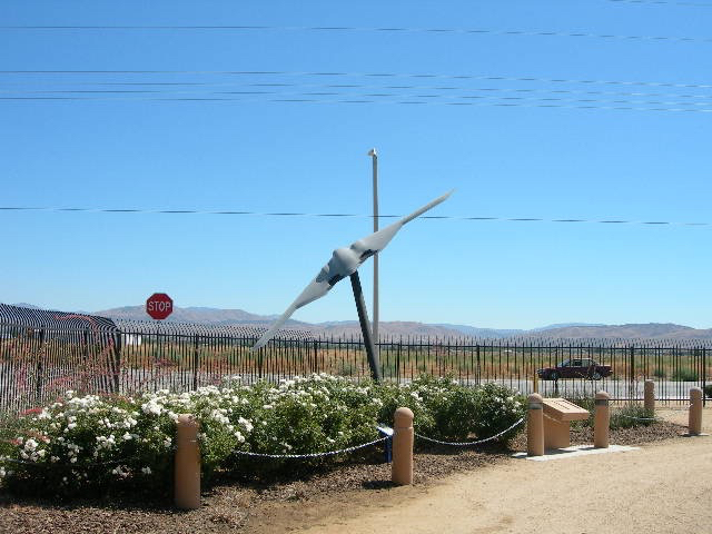
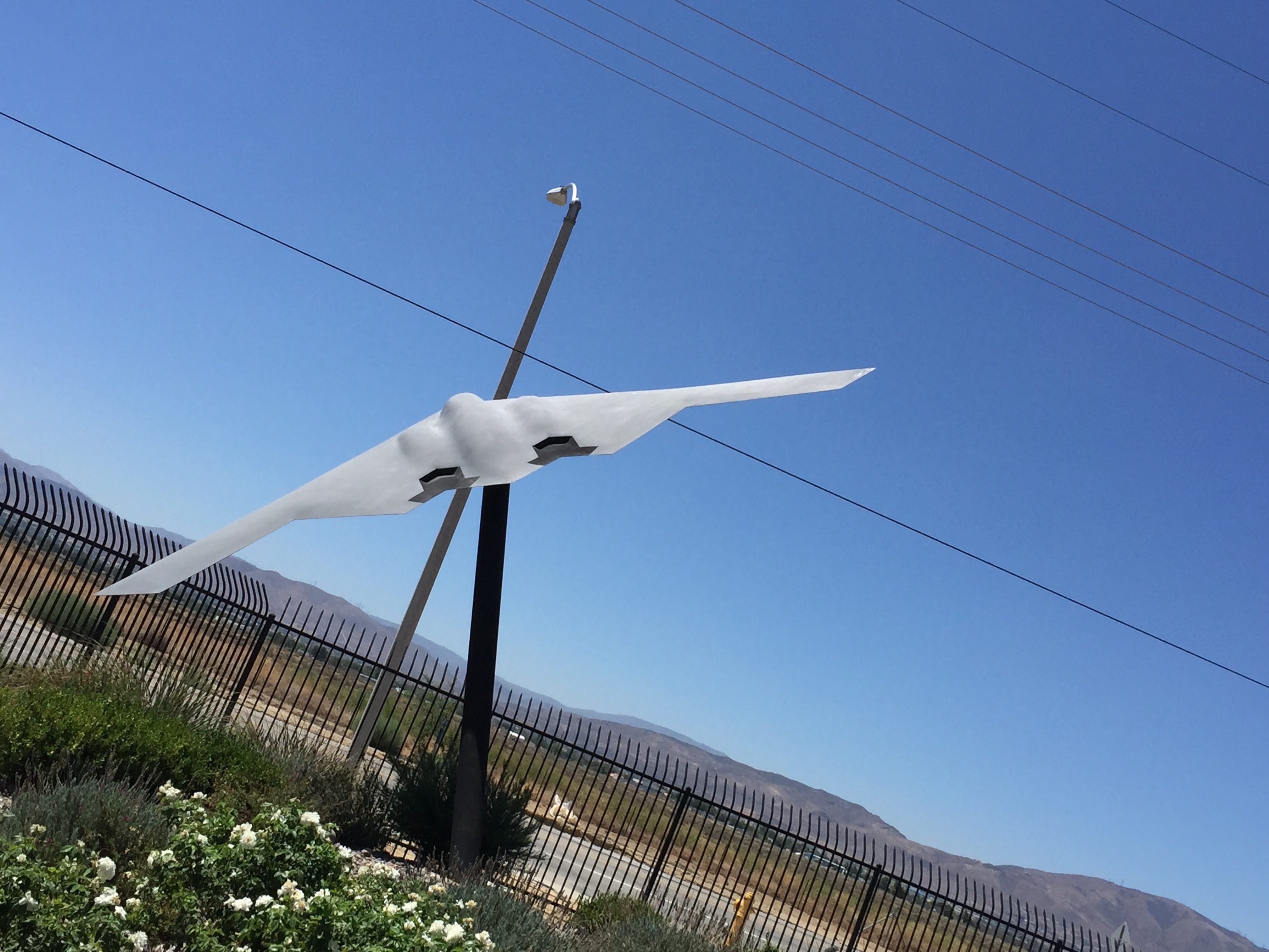
New Statue at South Base
page: 12
share:
Was exploring around the notorious Edwards AFB south base today on an app I use call US Topo Maps. If you don't have it, and like to explore maps
whilst you're bored on your mobile, I highly recommend it. It allows you to compare different satellite imagery databases alongside of one another
using an opacity filter, as well as Aeronautical & Nautical charts.
Anyways, I was exploring using the Google aerial filter, with Bing satellite at a lower opacity.
I was exploring the area around the B-2 shaped walkway, when I noticed something at these coordinates:
34°54'04.25"N 117°52'38.18"W
(34°54'04.25"N 117°52'38.18"W (WGS84))
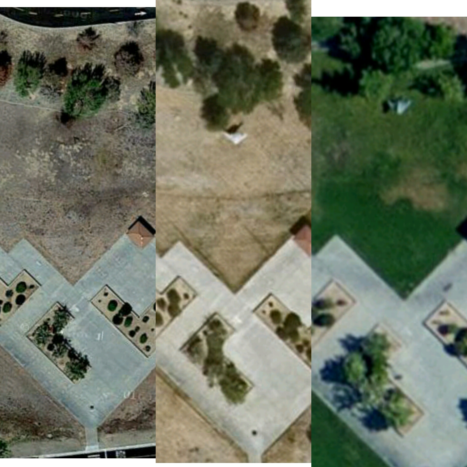
The image on the left is using the Google maps filter at 100%.
Center image is using the Bing aerial filter.
Right image is using the USGS Orthoimagery USGS EDC HRO filter.
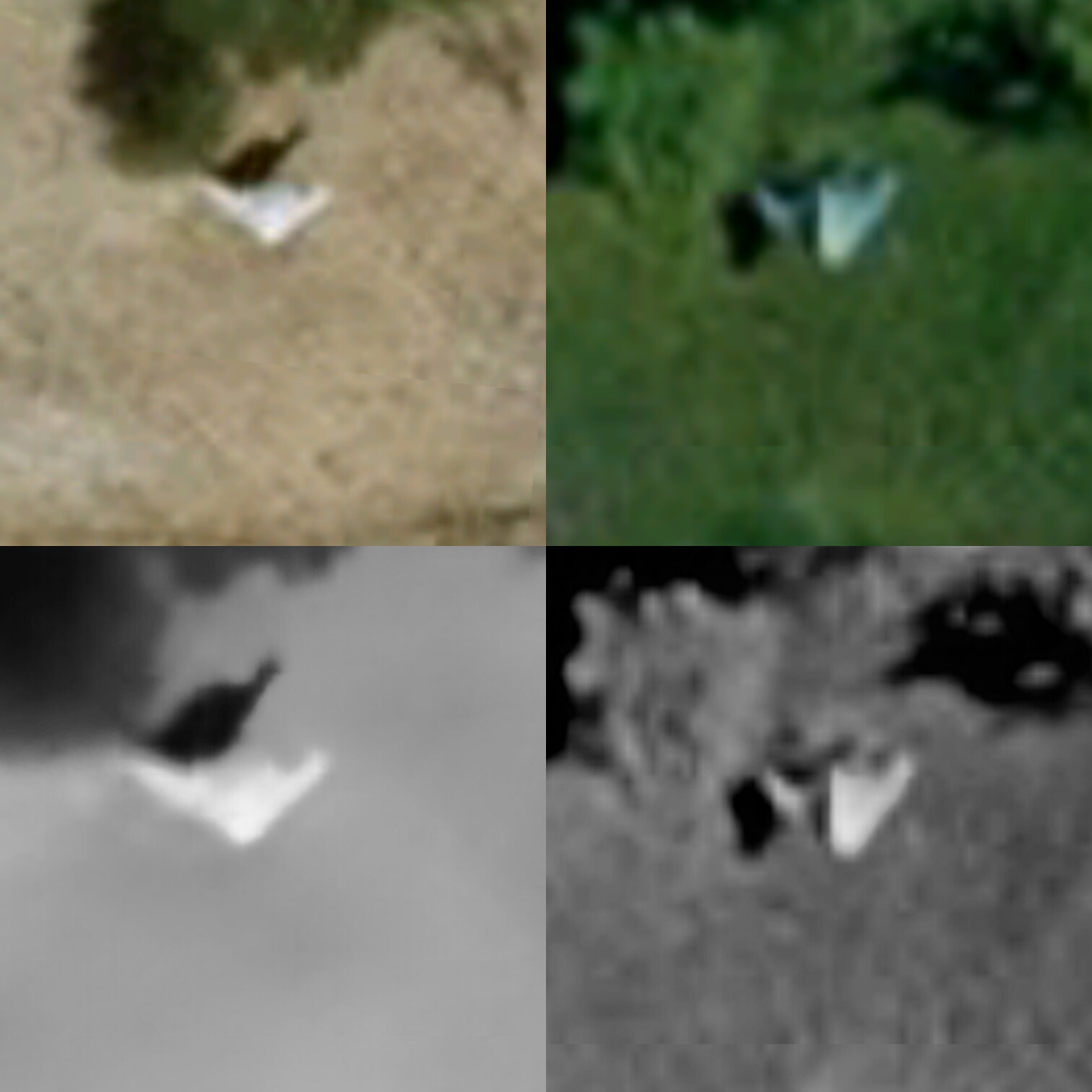
Second image is the center two images zoomed in much closer. Top images are without filter. Bottom images are using Snapseed to enhance/subtract certain distractions (enhancing shadows, lowering saturation, etc)
At first, this looked to me like an X-45, which was tested at South base or another one of it's variant, angled around 45° to present it in midflight.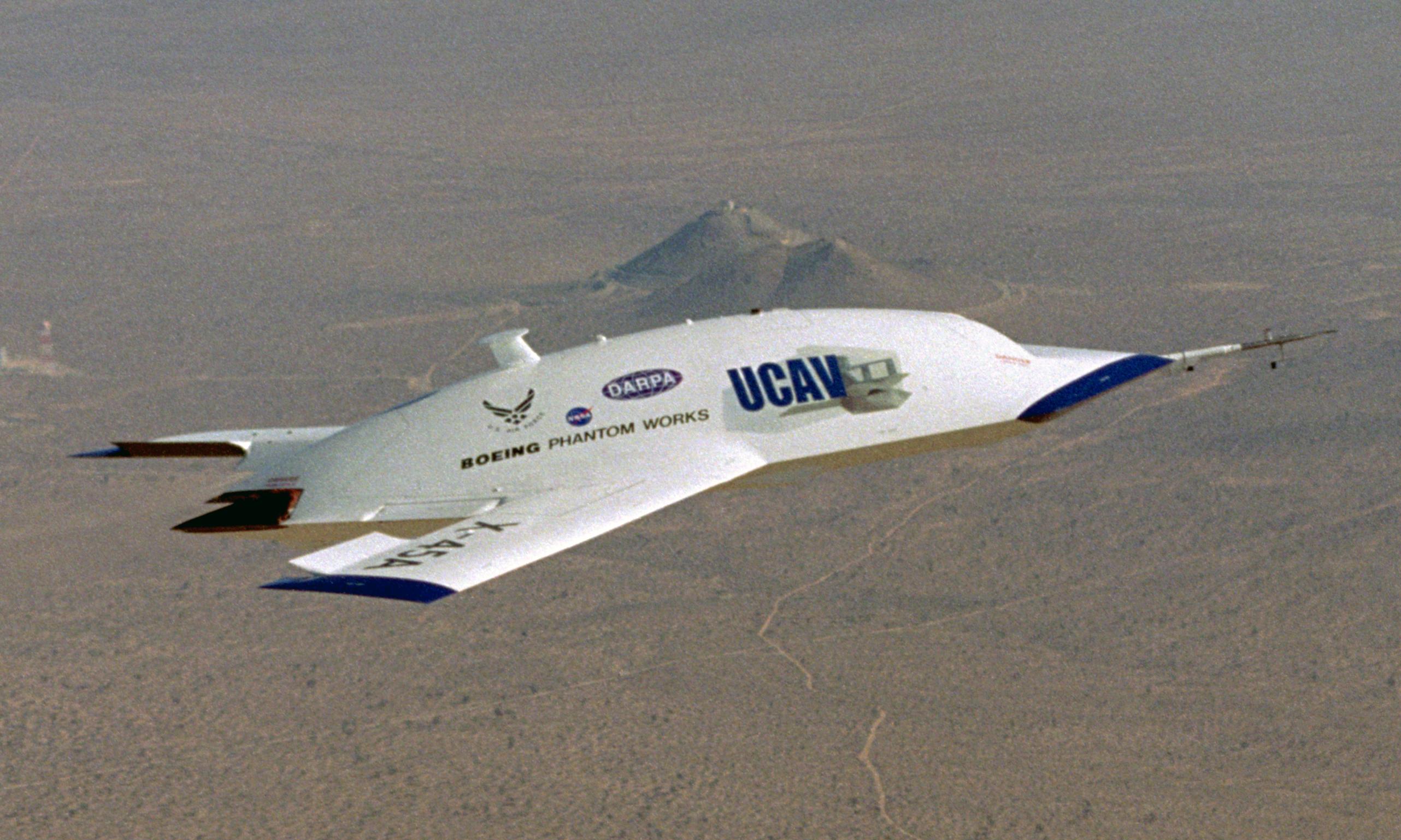 But doesn't it seem odd(and slightly offensive?) to put a statue of a Boeing project right on top of a Northrop
inspired walkway, no?
But doesn't it seem odd(and slightly offensive?) to put a statue of a Boeing project right on top of a Northrop
inspired walkway, no?
Then I remembered the air forces artist rendition of the B-21....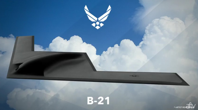
The shadows in the satellite images seem to show a difference than that of the B-2's aft section(there are, of course, many distortion effects that could alter the satellite image)
But very similar to the air forces B-21 rendition photo and X-45 wings.
What do you guys think?
Anyways, I was exploring using the Google aerial filter, with Bing satellite at a lower opacity.
I was exploring the area around the B-2 shaped walkway, when I noticed something at these coordinates:
34°54'04.25"N 117°52'38.18"W
(34°54'04.25"N 117°52'38.18"W (WGS84))
The image on the left is using the Google maps filter at 100%.
Center image is using the Bing aerial filter.
Right image is using the USGS Orthoimagery USGS EDC HRO filter.
Second image is the center two images zoomed in much closer. Top images are without filter. Bottom images are using Snapseed to enhance/subtract certain distractions (enhancing shadows, lowering saturation, etc)
At first, this looked to me like an X-45, which was tested at South base or another one of it's variant, angled around 45° to present it in midflight.
Then I remembered the air forces artist rendition of the B-21....
The shadows in the satellite images seem to show a difference than that of the B-2's aft section(there are, of course, many distortion effects that could alter the satellite image)
But very similar to the air forces B-21 rendition photo and X-45 wings.
What do you guys think?
edit on 9142016 by HomeyKXTA because: Repeat
a reply to: HomeyKXTA
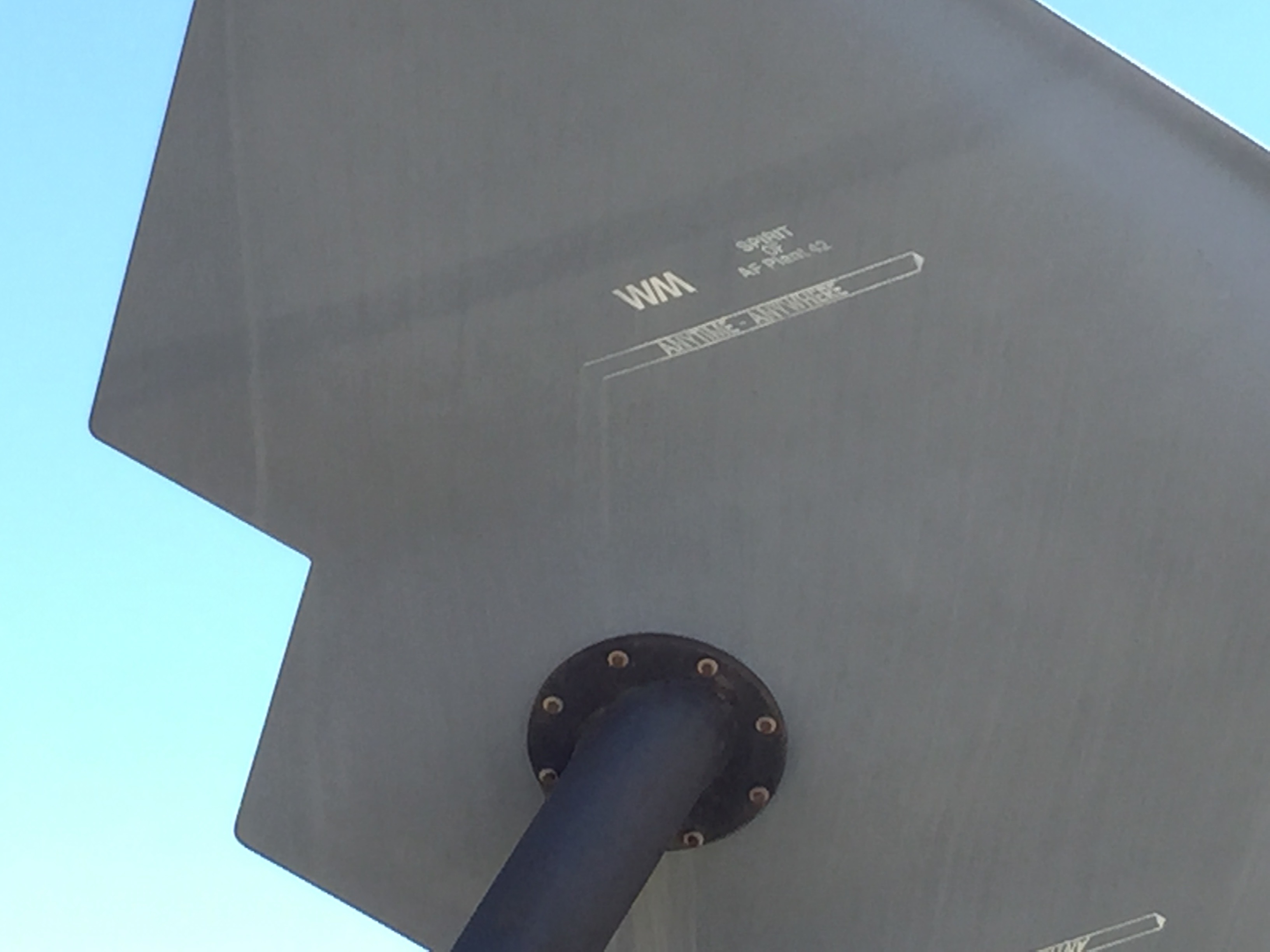
I have seen this in person, up close. It is a 1:8-scale model of the B-2. There are several identical models scattered around the Antelope Valley. Three that come immediately to mind are located at:
36.602512, -118.087243
34.671652, -118.112794
34.680698, -118.183917
I have seen this in person, up close. It is a 1:8-scale model of the B-2. There are several identical models scattered around the Antelope Valley. Three that come immediately to mind are located at:
36.602512, -118.087243
34.671652, -118.112794
34.680698, -118.183917
a reply to: Shadowhawk
Awesome! Thanks for the confirm!
I tried to search around to see if this had been discussed before, but could not.
Really appreciate the visual confirmation
Awesome! Thanks for the confirm!
I tried to search around to see if this had been discussed before, but could not.
Really appreciate the visual confirmation
originally posted by: Shadowhawk
a reply to: HomeyKXTA
I have seen this in person, up close. It is a 1:8-scale model of the B-2. There are several identical models scattered around the Antelope Valley. Three that come immediately to mind are located at:
Shadowhawk, I assume its like the one at Blackbird Park?
a reply to: FredT
It's exactly the same. Northrop Grumman must have donated a bunch of those things to local schools and parks. It is just a scale model (not any sort of radar or wind tunnel test article). They seem to have faded a bit over the years due to exposure to the weather.
It's exactly the same. Northrop Grumman must have donated a bunch of those things to local schools and parks. It is just a scale model (not any sort of radar or wind tunnel test article). They seem to have faded a bit over the years due to exposure to the weather.
new topics
-
Russia Flooding
Other Current Events: 1 hours ago -
MULTIPLE SKYMASTER MESSAGES GOING OUT
World War Three: 1 hours ago -
Two Serious Crimes Committed by President JOE BIDEN that are Easy to Impeach Him For.
US Political Madness: 2 hours ago -
911 emergency lines are DOWN across multiple states
Breaking Alternative News: 2 hours ago -
Former NYT Reporter Attacks Scientists For Misleading Him Over COVID Lab-Leak Theory
Education and Media: 4 hours ago -
Why did Phizer team with nanobot maker
Medical Issues & Conspiracies: 4 hours ago -
Pro Hamas protesters at Columbia claim hit with chemical spray
World War Three: 5 hours ago -
Elites disapearing
Political Conspiracies: 7 hours ago -
A Personal Cigar UFO/UAP Video footage I have held onto and will release it here and now.
Aliens and UFOs: 7 hours ago -
Go Woke, Go Broke--Forbes Confirms Disney Has Lost Money On Star Wars
Movies: 9 hours ago
top topics
-
British TV Presenter Refuses To Use Guest's Preferred Pronouns
Education and Media: 15 hours ago, 17 flags -
Go Woke, Go Broke--Forbes Confirms Disney Has Lost Money On Star Wars
Movies: 9 hours ago, 12 flags -
Pro Hamas protesters at Columbia claim hit with chemical spray
World War Three: 5 hours ago, 11 flags -
Trump To Hold Dinner with President of Poland At Trump Tower Tonight
2024 Elections: 17 hours ago, 8 flags -
Tucker Carlson interviews Christian pastor from Bethlehem.
Middle East Issues: 17 hours ago, 8 flags -
Elites disapearing
Political Conspiracies: 7 hours ago, 7 flags -
Freddie Mercury
Paranormal Studies: 9 hours ago, 7 flags -
A Personal Cigar UFO/UAP Video footage I have held onto and will release it here and now.
Aliens and UFOs: 7 hours ago, 5 flags -
Nirvana - Immigrant Song
Music: 14 hours ago, 5 flags -
Why did Phizer team with nanobot maker
Medical Issues & Conspiracies: 4 hours ago, 4 flags
active topics
-
MULTIPLE SKYMASTER MESSAGES GOING OUT
World War Three • 8 • : Zaphod58 -
Mood Music Part VI
Music • 3049 • : boozo -
Are the 'Abrahamic Religions' all Really the Worshipping the Same Abrahamic God?
Conspiracies in Religions • 191 • : ToneD -
Go Woke, Go Broke--Forbes Confirms Disney Has Lost Money On Star Wars
Movies • 16 • : GotterDameron23 -
Pro Hamas protesters at Columbia claim hit with chemical spray
World War Three • 12 • : GENERAL EYES -
Elites disapearing
Political Conspiracies • 17 • : AwakeNotWoke -
A family from Kansas with six children moved to the Moscow region
Other Current Events • 74 • : Freeborn -
The US Supreme Court Appears to Side With the January 6th 2021 Capitol Protestors.
Political Conspiracies • 43 • : GotterDameron23 -
Why did Phizer team with nanobot maker
Medical Issues & Conspiracies • 4 • : AwakeNotWoke -
Running Through Idiot Protestors Who Block The Road
Rant • 105 • : Astyanax
2