It looks like you're using an Ad Blocker.
Please white-list or disable AboveTopSecret.com in your ad-blocking tool.
Thank you.
Some features of ATS will be disabled while you continue to use an ad-blocker.

Desert National Wildlife Refuge Under Attack by USAF, East of Area 51
page: 1share:
This topic was discussed a while back. I recently asked the "Friends of Nevada Wilderness" on Facebook if there has been any updates.
This was their reply:
Thanks for checking! Here's a great recap of what's currently happening with the NDAA and the Desert National Wildlife Refuge:
Take Refuge: Desert National Wildlife Refuge Under Attack
It's a hurry up and wait scenario - the House version has the amendment to transfer the Refuge while the Senate does not. We are hopeful that when the versions are combined, the amendment will be stripped out.
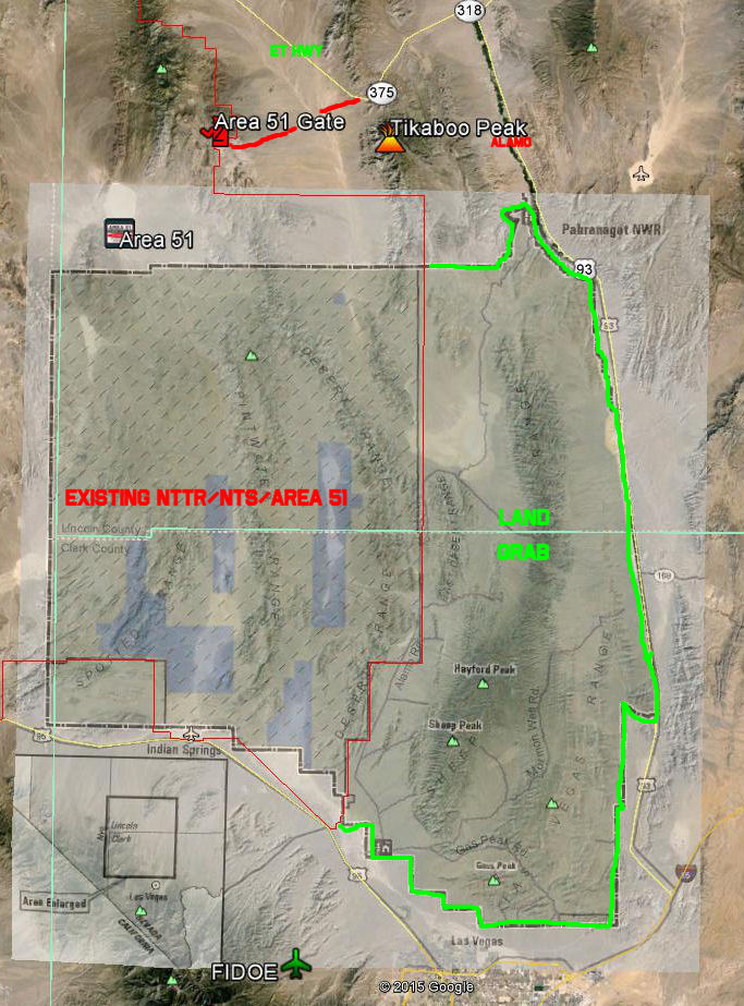
A reminder of what this encompasses - a huge section of a public wildlife refuge, east of the Nevada Test and Training Range and Area 51:
[SNIP]
This was their reply:
Thanks for checking! Here's a great recap of what's currently happening with the NDAA and the Desert National Wildlife Refuge:
Take Refuge: Desert National Wildlife Refuge Under Attack
It's a hurry up and wait scenario - the House version has the amendment to transfer the Refuge while the Senate does not. We are hopeful that when the versions are combined, the amendment will be stripped out.
A reminder of what this encompasses - a huge section of a public wildlife refuge, east of the Nevada Test and Training Range and Area 51:
[SNIP]
edit on 8/2/2016 by kosmicjack because: removed solicitation
hmmmm... lets see, a few thousand signatures at most, from civilians vs Area 51.
I wouldn't hold your breath.
I wouldn't hold your breath.
That Alamo Road drive is an exceptional off road experience. It hasn't been 100% passable for some time, but you can drive it half way from either
side.
I'm not sure you can legally grab land in the NDAA. The GOP has totally misappropriated the use of the bill, basically holding the DoD hostage with dubious amendments every time it comes up for a vote.
Also note that a land grab doesn't mean civilians can't use the land. Parts of the land around Stonewall Mountain are DoD owned, but civilians can travel on the DoD land. It is one of those deals where you aren't supposed to linger on the non-public land.
Gass Peak is a major telecom site. Hayford is a popular hiking destination.
I see RAND did a report on this land acquisition. I just found the link and it is 95 pages, so I'll get back to you all later. ;-)
www.rand.org...
If you don't follow RAND versus Brookings, RAND is the supposedly left leaning of the two think tanks.
www.rand.org...
If you don't follow RAND versus Brookings, RAND is the supposedly left leaning of the two think tanks.
originally posted by: gariac
That Alamo Road drive is an exceptional off road experience. It hasn't been 100% passable for some time, but you can drive it half way from either side.
I'm not sure you can legally grab land in the NDAA. The GOP has totally misappropriated the use of the bill, basically holding the DoD hostage with dubious amendments every time it comes up for a vote.
Also note that a land grab doesn't mean civilians can't use the land. Parts of the land around Stonewall Mountain are DoD owned, but civilians can travel on the DoD land. It is one of those deals where you aren't supposed to linger on the non-public land.
Gass Peak is a major telecom site. Hayford is a popular hiking destination.
That's part of my interest, I want to drive that Alamo Road next trip.
And the "Keeny Veach" disappearance, I want to try and check out that area.
originally posted by: gariac
I see RAND did a report on this land acquisition. I just found the link and it is 95 pages, so I'll get back to you all later. ;-)
www.rand.org...
If you don't follow RAND versus Brookings, RAND is the supposedly left leaning of the two think tanks.
"RAND Project AIR FORCE (PAF), a division of the RAND Corporation, is the U.S. Air Force’s federally funded research and development center for studies and analyses."
Yeah, I'm guessing how this report is gonna turn out.
originally posted by: gariac
I see RAND did a report on this land acquisition. I just found the link and it is 95 pages, so I'll get back to you all later. ;-)
www.rand.org...
If you don't follow RAND versus Brookings, RAND is the supposedly left leaning of the two think tanks.
Now I am getting confused - is the issue about National Wildlife Refuge FWS designated areas that are already within the "withdrawn lands" i.e. inside the NTTR border, or is this about trying to withdraw MORE land i.e. the land beneath the ALAMOA, ALAMOB, ALAMOC and SALLY MOA's? Guess I need to read more of this report.
edit on 3-8-2016 by FosterVS because: (no reason given)
a reply to: FosterVS
I need to reread it. The five possible plans are kind of confusing. Also I have a real problem if the area is actually designated wilderness since that means no mechanized machines, AKA SUVs, quads, etc. I see the quads violate the Wilderness Study Area (WSA) ti the east of Brainwash all the time.
Actually the "developer" (used loosely here) always pays for the studies. They probably picked RAND because the place has a reputation for being a bunch of Santa Monica neck beard beach bum hippies. Well at least according to Brookings, which we all know is a bunch of Washington elite!
At least this time the study is public, unlike the study for the new Yucca air facility or the study for the Tikaboo weather station. The fix was in on those studies.
My guess is if the USAF actually does want this land, it is for armed drones. They already have plenty of land to live bomb, but drones are slower and more likely to become lawn darts. They probably want more live bombing land near Creech, but again, there is plenty of nearby land to bomb.
a reply to: FosterVS
The spot in the middle that you aren't supposed to cross is very loose sand. There is a small dune nearby. Even when it wasn't closed, I decided to turn back. This was before I had satellite messaging.
You can see the back side of the Nellis range. There are those liter barrel markers.
Alamo Rd. meets up with the road to Tikaboo. If you fail to make one of the hairpin turns on the way to Tikaboo, you get on Alamo Rd. So you climb up a bit then down into this sand pit.
The ranchers maintain the Tikaboo road. (Or maybe the government does it for the ranchers.) The Alamo Rd. is not maintained. You would probably want to start early. It could take hours to drive the full stretch.
edit on 4-8-2016 by gariac because: typo
edit on 4-8-2016 by
gariac because: (no reason given)
edit on 4-8-2016 by gariac because: (no reason given)
I've digested this a bit. Here are my ramblings.
Abbreviations used in the RAND document:
DNWR Desert National Wildlife Refuge/Range
MRA Minimum Requirement Analysis
NTTR Nevada Test and Training Range
USFWS United States Fish and Wildlife Service
The land in question was designated the “Desert Game Range” in 1936 by Franklin D. Roosevelt by executive order.
www.presidency.ucsb.edu...
Map located here:
www.fws.gov...
The time line is such that this is the first designation of the land.
Referring to the RAND document:
The DNWR is land proposed to be a wildlife refuge, but has not been formally sanctioned to be one due to a lack of congressional action. However the fact that the land is proposed for a wildlife refuge means the land should be treated like one. The proposal dates back to 1974. The Las Vegas Bombing and Gunnery Range dates back to 1949. The range eventually became the NTTR. Thus the DoD activity on the land preceded the DNWR but was after the FDR executive order. How the DoD mucked up the game refuge could use some explaining! But quoting Admiral Grace Hopper : “It's easier to ask forgiveness than it is to get permission.”
Thus the bombing range overlapped the DNWR, creating two regions. One being DNWR land under what is now the NTTR, and the other being DNWR land adjacent to the NTTR.
From :
www.defendersblog.org...
“Unfortunately, a few in Congress want to give full control of the western half of the refuge to the Air Force, shutting out FWS from its duties to manage wildlife and their habitat on the refuge.”
Note they want to give the DoD full control of the western half, not the eastern half that is used by the public.
Now back to the RAND document.
The map on document page 34 (PDF page 48) presents the Venn diagram of land ownership. First concentrate on “withdrawn” land, which is highlighted in red. If the land is withdrawn from the public, it doesn't matter who owns it...you're not welcome. (Apparently there is some exception for bighorn sheep hunting on the DNWR land under the NTTR.)
Not shown on the RAND maps is Desert lake (AKA Thunderbird Lake), which is mostly under Alamo-Bravo, and Dog Bone Lake under 62A and 62B. Both are dry lakes. If you are going to drop live ordnance, dry lakes represent areas really hard to set on fire and also easy to clean up. This is probably why these areas were chosen for target practice in the first place.
Figure 2.2 on page 15 (PDF page 29) shows a helicopter route up the Sally corridor. These flights are commonly seen over route 93 way south of the NTTR. Further it indicates CSAR (combat search and rescue) on Range 61. Given the number of “civilian observers” around the front gate of Groom Lake, it is odd that no reports of CSAR activity or even the helicopters in the area, though the helicopters obviously enter the range somewhere. Not that this effects grabbing the remaining DNWR land since the helicopter activity is on the range (so they claim). I don't think this activity happens here but rather on the northern side of the NTTR based on scanner activity. Also the improvements to the Alamo airport make it less likely the USAF would want low level flights in the south east section of the NTTR. There is no tower at the Alamo airfield. Aircraft announce their intention on a CTAF (common traffic advisory frequency) and hope for the best.
Proposals:
1) “The USAF could try to get USFWS to withdraw the wilderness proposal for the DNWR lands that fall within the NTTR.”
This would involve congress and POTUS. The USAF would probably rather stay under the radar. If congress or POTUS gets in the game, anything can happen. Hint: land is useful if you want to name something after yourself. If a few critters get saved in the process, all the better!
2) “A second, more feasible, option is for the USAF to work with the USFWS to have the USFWS include more of the USAF operational considerations in the DNWR Complex CCP
implementation of the “revised proposal” for the DNWR proposed wilderness areas.”
Translation: get together, drink beer, make sure all parties have some skin in the game to ensure job security.
3) “A third option is for the USAF to work with USFWS to revise the 1997 USAF-USFWS
MOU regarding the DNWR.”
Translation: get together around a conference table, drink coffee, argue, write document, then drink beer.
4) “In a fourth option, the USAF could work with the USFWS to have USFWS conduct an MRA
for DNWR management activities, including USAF management considerations such as
allowing the building of a new dirt road.”
The MRA is a back door way to get things done. This won't require a land grab.
5) “A fifth option would involve the USAF trying to get the USFWS to conduct a wilderness
review process to see if NTTR’s DNWR lands still are suitable for the wilderness designation”
This means undo the wildlife designation, and would require the USFWS to give up turf if the USAF wins, or the USAF has to restore all the DNWR land they use now back to “nature”. This is the Dirty Harry “are you feeling lucky” plan. Not likely since everyone could lose.
a reply to: gariac
Ok, I've read most of that RAND report, and your post.
And as I understand it, per below:
"Thus the bombing range overlapped the DNWR, creating two regions. One being DNWR land under what is now the NTTR, and the other being DNWR land adjacent to the NTTR."
This ISN'T a proposed land grab of the "DNWR land adjacent to the NTTR".
More that they want to "undesignate" the wildlife designation of the DNWR area within the NTTR. So they can a) keep the wildlife officers out, and b) bomb the crap out of the whole area without any regard for wildlife
edit on 9-8-2016 by FosterVS because: (no reason given)
a reply to: FosterVS
Note the USAF doesn't want full control over the overlapping section, but rather the person or persons who included the rider on the NDAA.
I couldn't make much of reading the relevant section.
The NTTR has some wildlife issues even over the land that is not under the DNWR. Nellis has
to file environmental reports for the whole range periodically. Wild horse monitoring for one thing. But even details on how many generators they run for how many hours.
Groom Lake was the only location with carte blanche, and even that eventually changed.
www.lazygranch.com...
These old maps are interesting, though not 100% relevant.
NTTR Military Land Withdrawl Legislative Environmental Impact Statement Project Website
Nellis press release
Well so much for that story about the USAF not wanting the land. Full text in the link.
Nellis press release
Well so much for that story about the USAF not wanting the land. Full text in the link.
NELLIS AIR FORCE BASE, Nev. – The U.S. Air Force is preparing a Legislative Environmental Impact Statement, pursuant to the National Environmental Policy Act to evaluate potential environmental effects associated with the proposed land withdrawal by the United States of Air Force of the Nevada Test and Training Range.
The Air Force proposes to modernize the NTTR to improve the capacity and capability of the existing range. Modernization will support testing and training with more realistic and relevant capabilities to include advanced threat replication. Alternatives evaluated in the LEIS will include renewal of the current withdrawal and potential additional land withdrawal. The modernization is required to meet a rapidly changing battlespace which has outpaced the existing range capabilities and capacity in turn limiting realistic and relevant testing, tactics development, and training.
The Air Force’s proposed action includes renewal of the existing 2,949,603 acre public land withdrawal that expires November, 2021; the withdrawal and reservation for military use of up to 301,507 acres of additional adjacent public land and modification of range infrastructure to support the increased demand for testing and training. Requirements for training and testing at the NTTR have increased as a result of new test missions, F-35 training, Red Flag operations and increased irregular warfare training activities. The Bureau of Land Management, the United States Fish and Wildlife Service, Department of Energy, and Nevada Department of Wildlife will participate as cooperating agencies in the preparation of the LEIS. The Air Force has filed applications with BLM to extend the existing legislative withdrawal of public lands, and to withdraw additional land from all forms of appropriation under the public land laws, including the mining laws, mineral leasing laws and geothermal leasing laws.
originally posted by: gariac
NTTR Military Land Withdrawl Legislative Environmental Impact Statement Project Website
Nellis press release
Well so much for that story about the USAF not wanting the land. Full text in the link.
NELLIS AIR FORCE BASE, Nev. – The U.S. Air Force is preparing a Legislative Environmental Impact Statement, pursuant to the National Environmental Policy Act to evaluate potential environmental effects associated with the proposed land withdrawal by the United States of Air Force of the Nevada Test and Training Range.
The Air Force proposes to modernize the NTTR to improve the capacity and capability of the existing range. Modernization will support testing and training with more realistic and relevant capabilities to include advanced threat replication. Alternatives evaluated in the LEIS will include renewal of the current withdrawal and potential additional land withdrawal. The modernization is required to meet a rapidly changing battlespace which has outpaced the existing range capabilities and capacity in turn limiting realistic and relevant testing, tactics development, and training.
The Air Force’s proposed action includes renewal of the existing 2,949,603 acre public land withdrawal that expires November, 2021; the withdrawal and reservation for military use of up to 301,507 acres of additional adjacent public land and modification of range infrastructure to support the increased demand for testing and training. Requirements for training and testing at the NTTR have increased as a result of new test missions, F-35 training, Red Flag operations and increased irregular warfare training activities. The Bureau of Land Management, the United States Fish and Wildlife Service, Department of Energy, and Nevada Department of Wildlife will participate as cooperating agencies in the preparation of the LEIS. The Air Force has filed applications with BLM to extend the existing legislative withdrawal of public lands, and to withdraw additional land from all forms of appropriation under the public land laws, including the mining laws, mineral leasing laws and geothermal leasing laws.
Submit your concerns here. Not that it will likely do any good, and a mod here will likely snip this:
www.nttrleis.com...
I found this image as part of this document:
clearinghouse.nv.gov...
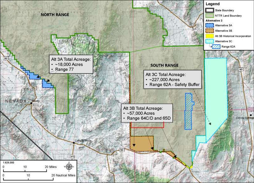
The land grab seems to encompass parts of land underneath MOA's ALAMO A, ALAMO B, ALAMO C, part of 63B, maybe part of 63B HIGH. If you look carefully (teal section noted as Alternative 3C), they are only grabbing the land north to the edge of the Desert National Wildlife Refuge. Which means the road in to Tikaboo Peak is safe.
Bigger version here:
www.topsecretbases.com...
clearinghouse.nv.gov...
The land grab seems to encompass parts of land underneath MOA's ALAMO A, ALAMO B, ALAMO C, part of 63B, maybe part of 63B HIGH. If you look carefully (teal section noted as Alternative 3C), they are only grabbing the land north to the edge of the Desert National Wildlife Refuge. Which means the road in to Tikaboo Peak is safe.
Bigger version here:
www.topsecretbases.com...
edit on 29-8-2016 by FosterVS because: teal section
The Air Force expansion would also overlap a designated energy transmission corridor (known as the 368 Energy Corridor) in two locations (Beatty and near Tule Springs National Monument), the current Vegas to Reno Off-Highway race course, and proposed mountain bike and hiking trails in the Beatty area.
news3lv.com... trainingtest-range-by-300k-acres
corridoreis.anl.gov...
bitd.com...
m.pvtimes.com... 2.html
These links should get you going.
originally posted by: gariac
The Air Force expansion would also overlap a designated energy transmission corridor (known as the 368 Energy Corridor) in two locations (Beatty and near Tule Springs National Monument), the current Vegas to Reno Off-Highway race course, and proposed mountain bike and hiking trails in the Beatty area.
news3lv.com... trainingtest-range-by-300k-acres
corridoreis.anl.gov...
bitd.com...
m.pvtimes.com... 2.html
These links should get you going.
Your links got butchered:
news3lv.com...
corridoreis.anl.gov...
m.pvtimes.com...
Nice of the BLM to segregate the land in question for 2 years, such that someone can't, say, file a mining claim to try and slow down or stop the withdrawal.
edit on 6-9-2016 by FosterVS because: (no reason given)
edit on 6-9-2016 by FosterVS because: (no reason
given)
One of the Air Force's proposed expansions would cover significant portions of Alamo Road, a 70-mile dirt road that traverses the refuge starting near the Corn Creek Visitor Center and ending near the town of Alamo and Pahranagat National Wildlife Refuge up north. The road offers a rugged, natural escape across beautiful desert wildlands. If the land is withdrawn, it is possible that public access will be restricted on this road, or prohibited entirely.
www.mojavedesertblog.com...
edit on 9-9-2016 by gariac because: (no reason given)
edit on 9-9-2016 by gariac because: (no reason given)
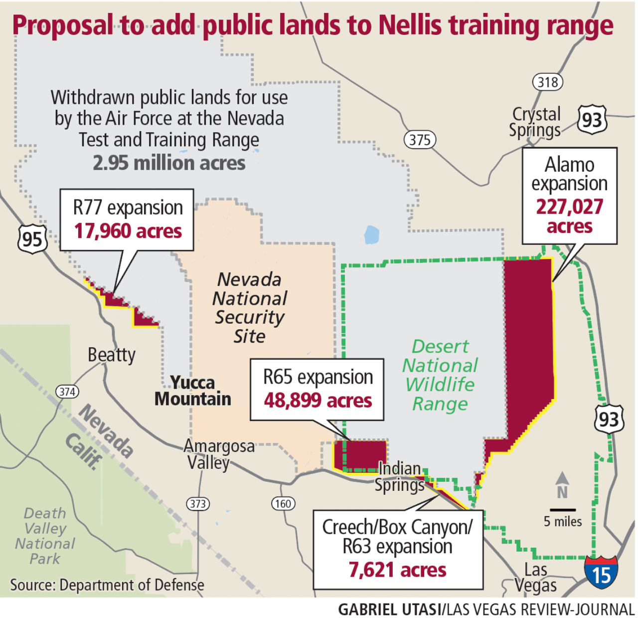
Another picture showing the territory the DoD wants to land-grab:
www.reviewjournal.com...
www.reviewjournal.com...
edit on 16-9-2016
by FosterVS because: (no reason given)
DNWR officials comment about the proposed DoD landgrab:
www.reviewjournal.com...
www.reviewjournal.com...
edit on
10-10-2016 by FosterVS because: (no reason given)
new topics
-
Hate makes for strange bedfellows
US Political Madness: 1 hours ago -
Who guards the guards
US Political Madness: 4 hours ago -
Has Tesla manipulated data logs to cover up auto pilot crash?
Automotive Discussion: 6 hours ago -
whistleblower Captain Bill Uhouse on the Kingman UFO recovery
Aliens and UFOs: 11 hours ago
top topics
-
CIA botched its handling of sexual assault allegations, House intel report says
Breaking Alternative News: 16 hours ago, 11 flags -
whistleblower Captain Bill Uhouse on the Kingman UFO recovery
Aliens and UFOs: 11 hours ago, 10 flags -
Who guards the guards
US Political Madness: 4 hours ago, 8 flags -
Hate makes for strange bedfellows
US Political Madness: 1 hours ago, 6 flags -
1980s Arcade
General Chit Chat: 13 hours ago, 5 flags -
Teenager makes chess history becoming the youngest challenger for the world championship crown
Other Current Events: 15 hours ago, 4 flags -
Deadpool and Wolverine
Movies: 14 hours ago, 4 flags -
Has Tesla manipulated data logs to cover up auto pilot crash?
Automotive Discussion: 6 hours ago, 2 flags
active topics
-
IDF Intel Chief Resigns Over Hamas attack
Middle East Issues • 42 • : TheWoker -
Candidate TRUMP Now Has Crazy Judge JUAN MERCHAN After Him - The Stormy Daniels Hush-Money Case.
Political Conspiracies • 682 • : network dude -
Hate makes for strange bedfellows
US Political Madness • 11 • : Terpene -
Deadpool and Wolverine
Movies • 4 • : FlyersFan -
British TV Presenter Refuses To Use Guest's Preferred Pronouns
Education and Media • 113 • : Consvoli -
"We're All Hamas" Heard at Columbia University Protests
Social Issues and Civil Unrest • 231 • : FlyersFan -
Fast Moving Disc Shaped UFO Captured on Camera During Flight from Florida to New York City
Aliens and UFOs • 20 • : MaximusNewmanus -
1980s Arcade
General Chit Chat • 14 • : ATruGod -
MULTIPLE SKYMASTER MESSAGES GOING OUT
World War Three • 94 • : Irishhaf -
Teenager makes chess history becoming the youngest challenger for the world championship crown
Other Current Events • 4 • : Consvoli