It looks like you're using an Ad Blocker.
Please white-list or disable AboveTopSecret.com in your ad-blocking tool.
Thank you.
Some features of ATS will be disabled while you continue to use an ad-blocker.

Two Ocean Floor Anomalies
page: 1share:
While browsing today, I came across a headline on one of those clickbait sites that read "Two Enormous Sunken Alien Bases Discovered on Google
Earth". (I won't link to the article, but a Google search of that headline will reveal several sites with a similar story.) My curiosity was
piqued and I went to the site to read the article. I don't believe for one second that they are alien bases, but the geometry of the "anomalies"
is interesting. I loaded up Google Earth and was able to find the locations:
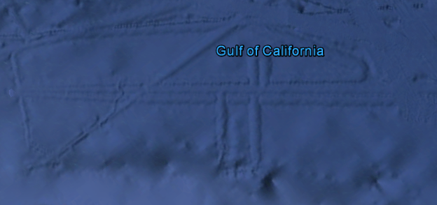
Anomaly One: "Gulf of California anomaly", 26°47'5.93"N, 110°36'49.53"W
Approximate dimensions: 80 miles x 30 miles. Virtually straight lines that intersect at 90° and 45° angles. Also a perfect "U" shaped ridge.
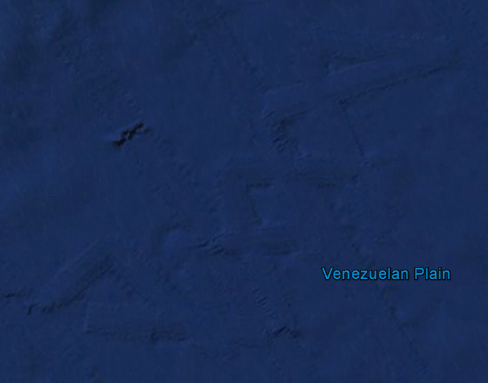
Anomaly Two: "Caribbean Sea anomaly", 14°18'18.83"N, 67°17'2.33"W
Approximate dimensions: 90 miles x 20 miles. Two intercepting zig-zag lines (double helix like)
I've tried to verify the images in the NASA World Wind app, but for some reason my version only shows low resolution images (not of just the ocean, but the entire planet). Maybe someone who has a working version can look them up.
Can anyone explain what these are or how they may have been formed?
Anomaly One: "Gulf of California anomaly", 26°47'5.93"N, 110°36'49.53"W
Approximate dimensions: 80 miles x 30 miles. Virtually straight lines that intersect at 90° and 45° angles. Also a perfect "U" shaped ridge.
Anomaly Two: "Caribbean Sea anomaly", 14°18'18.83"N, 67°17'2.33"W
Approximate dimensions: 90 miles x 20 miles. Two intercepting zig-zag lines (double helix like)
I've tried to verify the images in the NASA World Wind app, but for some reason my version only shows low resolution images (not of just the ocean, but the entire planet). Maybe someone who has a working version can look them up.
Can anyone explain what these are or how they may have been formed?
Those are ship sonar scanning lines, not some anomaly on the ocean floor. What they're looking for apart from shipwrecks and simple cataloging of the
seabed, I dunno.
still, as big as they are....it's a hail of an anomaly, huh!!!
like the underwater base there also.....from a thread ATS
like the underwater base there also.....from a thread ATS
originally posted by: SentientCentenarian
Those are ship sonar scanning lines, not some anomaly on the ocean floor. What they're looking for apart from shipwrecks and simple cataloging of the seabed, I dunno.
I second that
Sry no submerge alien base there
edit on 30-7-2016 by Spacespider because: (no reason given)
a reply to: Shadoefax
I definitely think I see something in these photos that is not of any kind of natural origin.
90% angles? Sorry, the probability of them not being natural but rather being man made is overwhelming.
I definitely think I see something in these photos that is not of any kind of natural origin.
90% angles? Sorry, the probability of them not being natural but rather being man made is overwhelming.
edit on 30-7-2016 by antiguaEstrella because: Iron hangars suck, mommy.
a reply to: SentientCentenarian
I've puzzled over these interesting markings, lines, and designs before on Google Earth. Very nice to finally have an explanation! Thank you.
I've puzzled over these interesting markings, lines, and designs before on Google Earth. Very nice to finally have an explanation! Thank you.
I made a thread about the two other really big ones off the coast of Peru..
People shrugged it off as a satellite picture issue, im still not so sure though as the perfect patterns seem really odd
www.abovetopsecret.com...
People shrugged it off as a satellite picture issue, im still not so sure though as the perfect patterns seem really odd
www.abovetopsecret.com...
originally posted by: SentientCentenarian
Those are ship sonar scanning lines, not some anomaly on the ocean floor.
It that is so, I wonder why Google Earth bothers to include them. If they do not portray physical properties of the ocean floor, what would be the purpose of aggregating the data and implementing it? It would be more honest to just show nothing but a flat, featureless surface.
a reply to: Shadoefax
Here is from today's stories on this "anomally" from DISCLOSETV.COM. The site itself and story are suspect...
www.disclose.tv...
Here is from today's stories on this "anomally" from DISCLOSETV.COM. The site itself and story are suspect...
www.disclose.tv...
originally posted by: antiguaEstrella
a reply to: Shadoefax
I definitely think I see something in these photos that is not of any kind of natural origin.
90% angles? Sorry, the probability of them not being natural but rather being man made is overwhelming.
They are man made. They are sonar scanning lines. It's basically where they have used sonar to scan the bottom of the ocean and so that particular area has more information/resolution. The ships go in straight lines. It's as if they had a blurry picture and made small portions unblurry.
originally posted by: Shadoefax
originally posted by: SentientCentenarian
Those are ship sonar scanning lines, not some anomaly on the ocean floor.
It that is so, I wonder why Google Earth bothers to include them. If they do not portray physical properties of the ocean floor, what would be the purpose of aggregating the data and implementing it? It would be more honest to just show nothing but a flat, featureless surface.
Why would you remove data? Over time more and more data will be available and the ocean floor will become more featureful. What would be the point of removing information?
I think I'm missing something here. Are these patterns physically on the ocean floor?
If the answer is "yes" and they were created by sonar (and sonar is the primary method used to determine ocean floor features), why don't similar patterns appear everywhere on Google Earth?
If the answer is "no" and they are only artifacts appearing on sonar images and don't represent true, physical features, then what is the point of including them in Google Earth? And again, why don't similar patterns appear everywhere on Google Earth?
a reply to: Shadoefax
There is no physical pattern, no alteration. It's basically a part of the ocean floor we have high rez images of because it was mapped with sonar. The ocean around it is the regular low resolution images.
oceanservice.noaa.gov...
There is no physical pattern, no alteration. It's basically a part of the ocean floor we have high rez images of because it was mapped with sonar. The ocean around it is the regular low resolution images.
The lines seen here show the paths taken by ships using sonar to map small sections of the ocean floor in greater detail.
While these formations are human-made, they are only made of data. In other words, there are no physical lines on the ocean floor. These lines are artifacts of the ocean floor mapping process.
oceanservice.noaa.gov...
edit on 31-7-2016 by OccamsRazor04 because: (no reason given)
originally posted by: antiguaEstrella
a reply to: Shadoefax
I definitely think I see something in these photos that is not of any kind of natural origin.
90% angles? Sorry, the probability of them not being natural but rather being man made is overwhelming.
I see that argument quite a bit, not sure where it originates but nature says otherwise-
www.abovetopsecret.com...
originally posted by: OccamsRazor04
There is no physical pattern, no alteration. It's basically a part of the ocean floor we have high rez images of because it was mapped with sonar. The ocean around it is the regular low resolution images.
The lines seen here show the paths taken by ships using sonar to map small sections of the ocean floor in greater detail.
Well, if the patterns are supposed to contain high-resolution images, they are not evident in Google Earth. I can zoom in on my backyard and see weeds in the flowerbed, but I can see no extra detail when zooming in the sonar images. In my opinion, it would be better just to leave these sonar created false images out completely. They do nothing but advance conspiracy theories and confuse Google Earth users.
a reply to: Shadoefax
It is perfectly evident. I don't know why you want less data. It's been explained why you want to keep arguing is beyond me.
www.gearthblog.com...
I will prefer more data every time. Anyone who sees conspiracy theories here and doesn't acknowledge the facts is someone who will see them no matter what you do.
originally posted by: OccamsRazor04
a reply to:
It is perfectly evident.
With all due respect, no ... it is not evident at all. If you zoom in to any spot that is supposed to show high-resolution imagery, all you see is a featureless blue screen.
I don't know why you want less data.
I want to see any data that represents a true image of the ocean floor, not arbitrary boundary lines of areas that are supposed to contain high-resolution imagery but actually don't.
originally posted by: OccamsRazor04
a reply to: Shadoefax
There is no physical pattern, no alteration. It's basically a part of the ocean floor we have high rez images of because it was mapped with sonar. The ocean around it is the regular low resolution images.
The lines seen here show the paths taken by ships using sonar to map small sections of the ocean floor in greater detail.
While these formations are human-made, they are only made of data. In other words, there are no physical lines on the ocean floor. These lines are artifacts of the ocean floor mapping process.
oceanservice.noaa.gov...
Right.
Sonar anomalies are to underwater bases as drones and ball lightning are to UFOs.
To me it's plausible that these are all just convenient fake excuses.
Totally unverifiable and thus beyond suspicion?
new topics
-
12 jurors selected in Trump criminal trial
US Political Madness: 1 hours ago -
Iran launches Retalliation Strike 4.18.24
World War Three: 2 hours ago -
Israeli Missile Strikes in Iran, Explosions in Syria + Iraq
World War Three: 2 hours ago -
George Knapp AMA on DI
Area 51 and other Facilities: 8 hours ago -
Not Aliens but a Nazi Occult Inspired and then Science Rendered Design.
Aliens and UFOs: 8 hours ago -
Louisiana Lawmakers Seek to Limit Public Access to Government Records
Political Issues: 10 hours ago -
The Tories may be wiped out after the Election - Serves them Right
Regional Politics: 11 hours ago
top topics
-
BREAKING: O’Keefe Media Uncovers who is really running the White House
US Political Madness: 15 hours ago, 25 flags -
George Knapp AMA on DI
Area 51 and other Facilities: 8 hours ago, 23 flags -
Biden--My Uncle Was Eaten By Cannibals
US Political Madness: 16 hours ago, 18 flags -
Israeli Missile Strikes in Iran, Explosions in Syria + Iraq
World War Three: 2 hours ago, 12 flags -
"We're All Hamas" Heard at Columbia University Protests
Social Issues and Civil Unrest: 16 hours ago, 7 flags -
Louisiana Lawmakers Seek to Limit Public Access to Government Records
Political Issues: 10 hours ago, 7 flags -
So I saw about 30 UFOs in formation last night.
Aliens and UFOs: 13 hours ago, 5 flags -
Not Aliens but a Nazi Occult Inspired and then Science Rendered Design.
Aliens and UFOs: 8 hours ago, 4 flags -
Iran launches Retalliation Strike 4.18.24
World War Three: 2 hours ago, 4 flags -
The Tories may be wiped out after the Election - Serves them Right
Regional Politics: 11 hours ago, 3 flags
active topics
-
12 jurors selected in Trump criminal trial
US Political Madness • 19 • : JadedGhost -
Pfizer is 'deeply sorry'
Diseases and Pandemics • 23 • : VoiceofReality -
Israeli Missile Strikes in Iran, Explosions in Syria + Iraq
World War Three • 47 • : YourFaceAgain -
It has begun... Iran begins attack on Israel, launches tons of drones towards the country
World War Three • 887 • : 5thHead -
The Tories may be wiped out after the Election - Serves them Right
Regional Politics • 20 • : ScarletDarkness -
Terrifying Encounters With The Black Eyed Kids
Paranormal Studies • 44 • : Consvoli -
George Knapp AMA on DI
Area 51 and other Facilities • 20 • : theshadowknows -
BREAKING: O’Keefe Media Uncovers who is really running the White House
US Political Madness • 14 • : pianopraze -
British TV Presenter Refuses To Use Guest's Preferred Pronouns
Education and Media • 63 • : Consvoli -
Russia Ukraine Update Thread - part 3
World War Three • 5695 • : Arbitrageur