It looks like you're using an Ad Blocker.
Please white-list or disable AboveTopSecret.com in your ad-blocking tool.
Thank you.
Some features of ATS will be disabled while you continue to use an ad-blocker.

Lake Balkhash, Kazakhstan. What is That?!
page: 19
share:
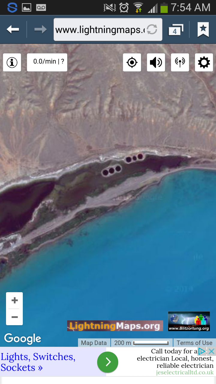
I took some screen shots earlier on of google earth and noticed on the far eastern side of lake balkhash, there is this pair of things (could be
holes).... anyone know what they are?! I cant seem to upload the pics atm but will keep trying... when you find the area... zoom in.
Anyone??!!!
edit on 31-5-2016 by jellybeansunex7 because: additional info
Anyone??!!!
edit on 31-5-2016 by jellybeansunex7 because: extra
Sounds like an awesome lake,
www.mnn.com...
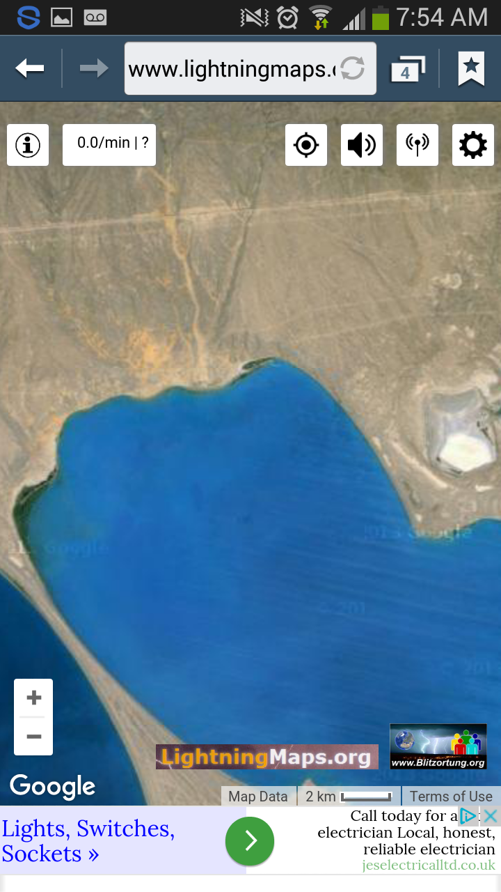
Located in Kazakhstan, Lake Balkhash is the 12th (google claims 15th) largest lake in the world, but that characteristic is hardly what makes it interesting. This lake is bizarre because half of the lake consists of freshwater and the other half is saltwater.
Balkhash maintains this unlikely balance in part because the two halves are joined by a narrow straight that is 3.5 kilometers wide and six meters deep.
There is some concern that Lake Balkhash could dry up like the Aral Sea, since many of its source waters are being diverted.
www.mnn.com...
a reply to: jellybeansunex7
How about giving us the Latitude and Longitude of those holes so we can see for our-self.
Thanks
How about giving us the Latitude and Longitude of those holes so we can see for our-self.
Thanks
It was on lightningmaps.org .... I dont longitude and latutude for them. If you look along the top right hand eastern corner of the lake close up,
you'll see them. Zoom in toward the eastern side and look for the little green area by the spit.....
a reply to: MinangATS
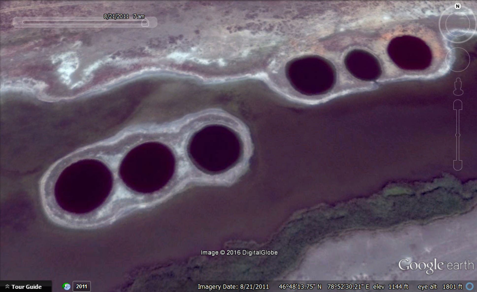
N46.80 E78.87
Very interesting site. Too regular to be natural, ca 300 m diameters. But not seen some big infrastructures nearby, only few 4x4 tracks.
Something maybe at Soviet Era and Balkhas dries up novadays, so 20-40-60 years ago there was much more deep water.
N46.80 E78.87
Very interesting site. Too regular to be natural, ca 300 m diameters. But not seen some big infrastructures nearby, only few 4x4 tracks.
Something maybe at Soviet Era and Balkhas dries up novadays, so 20-40-60 years ago there was much more deep water.
a reply to: jellybeansunex7
Cool spot but i would think they are related to the Soviet military (rather than Russian military).
The Lake Baikal area was home to several ICBM silos and also used for testing missiles (so to Reldra i would say that i don't advise swimming!). Even Russian Military divers don't like going into it, which should should show you how bad it actually is!
It is a very cool ancient Lake though. Huge historical interest in the area (postulated as possible resting place of Genghis Khan, amongst other very cool facts). And because it is a rift lake, it has had some fairly dramatic shorelines over the years (as in changes to height of the water, both up and down). There are submerged ruins there, including an old monastery. The surrounding area is covered in petroglyphs.
Anyhoo, back to the Lake itself........this is one of those areas where locals walked off with nuclear material post fall of Communism.......
Semipalatinsk Nunclear Testing Facility is near by, among with Kurchatov facility was there with my father right after USSR collapsed. Lake Balkhash
indeed a beautiful place, some of the areas are still virgin, others not so much.
originally posted by: Kandinsky
a reply to: MinangATS
They look like water treatment features. Instead of seeing 'holes,' they're more likely to be basins of water. Desalination works?? Sewage treatment??
Just spit-balling.
Maybe it's a method of extracting salt from seawater. There seems to be a lot of white material lying about the roads there.
a reply to: smurfy
No, locals not extracting salt here, but yea, these whiteish regions are salined soil because water level and -volume shrinks constantly about last 50 years. This is because chinese used up more and more riverwater. If there anything mined, then copper, but i never heard any underwater copper mines yet.
And btw. Balkhas is a LAKE, not a sea. However and very strange, eastern part of lake is salty, but western part is drinkable. This because western part got a lot of more freshwater income.
***
Still searching solution for this mystery, i really like that kind of tasks, tnx OP. No clue for internet searches yet, but 6 km (3,7 miles) NNW there is one strange railwaystation middle of nowhere... why they hold this up? Last google imagery past 2011, need lookin' some other mapping sources too.
originally posted by: SaddledMummy
...but 6 km (3,7 miles) NNW there is one strange railwaystation middle of nowhere... why they hold this up?
I cannot see the station, can you post a picture? Forget it, I found it.
Looks like a work site as there are two sidings there as well.
edit on 31-5-2016 by AugustusMasonicus because: Ph'nglui mglw'nafh Cthulhu R'lyeh wgah'nagl fhtagn
a reply to: Kandinsky
I was thinking the same thing, there is no obvious road to them though so maybe old and abandoned, the soviet's had all kind's of wasted project's and it may be just another of those.
Salt extraction is the best suggestion made by yourself and several other's or perhaps failed fishery's of some kind though the water in them look's very dark compared to the lake itself?.
I thought maybe deep but the middle upper right one seem's to have a damaged bank on it's lower side and to have lost some of the water from within it, so that make it appear smaller than the other five which are of more or less uniform size and if that is the reason then they seem to be basin like rather than sink hole like features, so yes some form of water treatment or fisheries of some kind.
There has also been a lot of climate change there over the past several thousand years so just maybe they are not so knew either.
Apparently there are copper deposites nearby as well so maybe to do whith that.
www.lakepedia.com...
new topics
-
Electrical tricks for saving money
Education and Media: 2 hours ago -
VP's Secret Service agent brawls with other agents at Andrews
Mainstream News: 4 hours ago -
Sunak spinning the sickness figures
Other Current Events: 4 hours ago -
Nearly 70% Of Americans Want Talks To End War In Ukraine
Political Issues: 5 hours ago -
Late Night with the Devil - a really good unusual modern horror film.
Movies: 6 hours ago -
Cats Used as Live Bait to Train Ferocious Pitbulls in Illegal NYC Dogfighting
Social Issues and Civil Unrest: 8 hours ago -
The Good News According to Jesus - Episode 1
Religion, Faith, And Theology: 10 hours ago
top topics
-
Cats Used as Live Bait to Train Ferocious Pitbulls in Illegal NYC Dogfighting
Social Issues and Civil Unrest: 8 hours ago, 8 flags -
Florida man's trip overseas ends in shock over $143,000 T-Mobile phone bill
Social Issues and Civil Unrest: 15 hours ago, 8 flags -
VP's Secret Service agent brawls with other agents at Andrews
Mainstream News: 4 hours ago, 8 flags -
Former Labour minister Frank Field dies aged 81
People: 17 hours ago, 4 flags -
HORRIBLE !! Russian Soldier Drinking Own Urine To Survive In Battle
World War Three: 12 hours ago, 3 flags -
Nearly 70% Of Americans Want Talks To End War In Ukraine
Political Issues: 5 hours ago, 3 flags -
Sunak spinning the sickness figures
Other Current Events: 4 hours ago, 3 flags -
Bobiverse
Fantasy & Science Fiction: 15 hours ago, 3 flags -
Electrical tricks for saving money
Education and Media: 2 hours ago, 3 flags -
Late Night with the Devil - a really good unusual modern horror film.
Movies: 6 hours ago, 2 flags
active topics
-
TLDR post about ATS and why I love it and hope we all stay together somewhere
General Chit Chat • 10 • : theshadowknows -
VP's Secret Service agent brawls with other agents at Andrews
Mainstream News • 31 • : WeMustCare -
Why to avoid TikTok
Education and Media • 20 • : 5thHead -
How ageing is" immune deficiency"
Medical Issues & Conspiracies • 32 • : annonentity -
-@TH3WH17ERABB17- -Q- ---TIME TO SHOW THE WORLD--- -Part- --44--
Dissecting Disinformation • 657 • : daskakik -
President BIDEN Vows to Make Americans Pay More Federal Taxes in 2025 - Political Suicide.
2024 Elections • 135 • : WeMustCare -
HORRIBLE !! Russian Soldier Drinking Own Urine To Survive In Battle
World War Three • 30 • : DaRAGE -
Spectrophilia - Women Who Have Had Affairs With Ghosts Say Spooks Are Better Lovers Than Real Men
Paranormal Studies • 32 • : burritocat -
Electrical tricks for saving money
Education and Media • 2 • : rickymouse -
Cats Used as Live Bait to Train Ferocious Pitbulls in Illegal NYC Dogfighting
Social Issues and Civil Unrest • 18 • : Xtrozero
9