It looks like you're using an Ad Blocker.
Please white-list or disable AboveTopSecret.com in your ad-blocking tool.
Thank you.
Some features of ATS will be disabled while you continue to use an ad-blocker.

Climate Change Denial, Anyone?
page: 19share:
originally posted by: TiredofControlFreaks
a reply to: bigyin
Bigyin
No matter how you slice it or dice it, we need to understand that the ocean comprises about 78 % of the earth's crust. Heat from the sun penetrates the water to a much greater extent than land. Ocean's accumulate heat over period of time.
Correct, which is why ocean heat content is a better measure of global warming than surface temperatures (land or sea), and this dataset shows unremitting increase for decades, as we would expect from global warming.
Then the heat is discharged through the Pacific Decadal Oscilliation of which El Nino and La Nino are to cyclic normal occurrences.
Tired of Control Freaks
And the amount of heat is continuing to increase because of increased radiative forcing from the increased greenhouse effects.
The observations are oscillations on an upward trend, as all climate physics predicts.
edit on 21-6-2016 by mbkennel because: (no reason
given)
a reply to: mbkennel
Actually check again...the oceans are quite cool at the moment and expected to get cooler
public.wmo.int...
Tired of Control Freaks
Actually check again...the oceans are quite cool at the moment and expected to get cooler
public.wmo.int...
he 3-month mean sea surface temperature in the central tropical Pacific of well over 2 degrees Celsius above average during the peak of the 2015-16 El Niño indicates that it was comparable in strength to the previous very strong events of 1982-83 and 1997-98. While the peak ocean temperatures were approximately as strong as those of the 1997-98 event, other aspects of the 2015-16 El Niño were weaker, such as the sea surface temperature and subsurface temperature in the eastern one-third of the tropical Pacific, and the eastward extent of enhanced cloudiness and rainfall along the equator.
Tired of Control Freaks
a reply to: TiredofControlFreaks
Your source does not say that. It's talking about surface temperatures in the eastern and central pacific (not "the oceans") and it does not say they are "quite cool."
Actually check again...the oceans are quite cool at the moment and expected to get cooler
edit on 6/23/2016 by Phage because: (no reason given)
originally posted by: TiredofControlFreaks
a reply to: mbkennel
Actually check again...the oceans are quite cool at the moment and expected to get cooler
public.wmo.int...
he 3-month mean sea surface temperature in the central tropical Pacific
There you go: sea-surface temperature in central tropical Pacific. My entire point was contrasting surface temperatures (subject to substantial fluctuation and low heat capacity on land) with ocean heat content.
Sea surface temperature is not ocean heat content over a wide range of depths.
And global warming is global, not central tropical Pacific.
edit on 23-6-2016 by mbkennel because: (no reason given)
edit on
23-6-2016 by mbkennel because: (no reason given)
a reply to: mbkennel
Actually, global warming is NOT global. There is a huge hemispheric difference between the northern and southern hemispheres (just like the medieval warming period, which for some reason is NOT considered global while the current warming IS considered global
As for the sea surface temperature, point well taken however....
The BLOB of heat as dissappated
earthobservatory.nasa.gov...
Tired of Control Freaks
Actually, global warming is NOT global. There is a huge hemispheric difference between the northern and southern hemispheres (just like the medieval warming period, which for some reason is NOT considered global while the current warming IS considered global
As for the sea surface temperature, point well taken however....
The BLOB of heat as dissappated
earthobservatory.nasa.gov...
In July 2015, temperatures were unusually warm across a large swath from the Gulf of Alaska to the California coast. By January 2016, more seasonable temperatures had returned. The development came as no surprise to weather watchers. In September 2015, Clifford Mass, a University of Washington atmospheric scientist, explained in his blog that El Niño generally brings lower-than-normal sea surface pressures to the eastern Pacific—the opposite of the systems that sustained the blob. By mid-December 2015, Mass declared that the blob was dead. Remnants of the warm water patch still persist. “There are significant temperature anomalies extending down to a depth of about 300 meters. So while the weather patterns the past few months have not been that favorable to warming, it will take a while for all of the accumulated heat to go away,” explained Bond. That means impacts on marine life and on weather in the Pacific Northwest could linger, though Bond does not think the blob will return in the near term.
Tired of Control Freaks
a reply to: TiredofControlFreaks
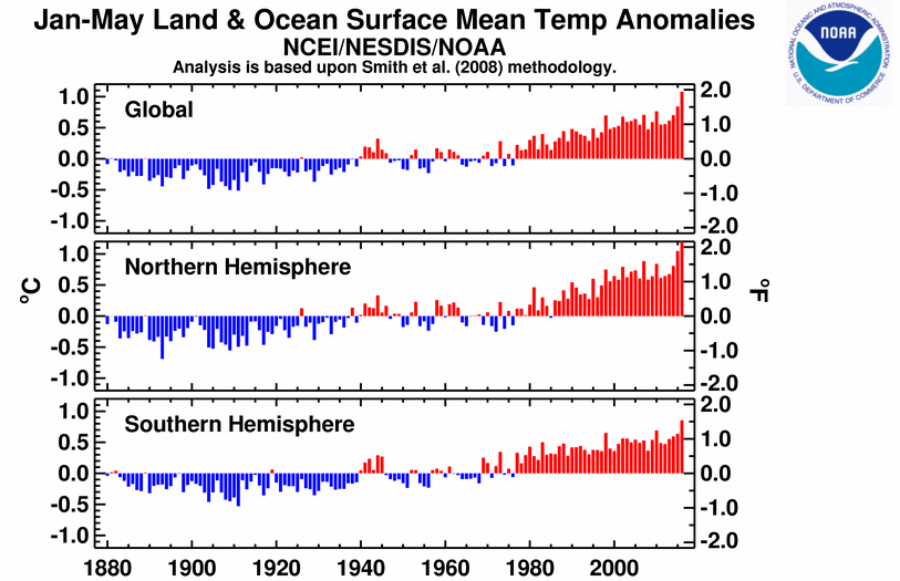
Not really. While the southern hemisphere is not warming as quickly as the northern hemisphere, it is indeed warming.
There is a huge hemispheric difference between the northern and southern hemispheres
Not really. While the southern hemisphere is not warming as quickly as the northern hemisphere, it is indeed warming.
a reply to: Phage
so when the southern hemisphere did not warm as much as the northern hemisphere during the MWP, the MWP was considered only a "regional" phenomena but now under the exact same conditions its a global phenomena?
Would you care to explain this dichotomy?
Further, just because half the global is warming above the 20th century "average", what does that signify? Average means average. Sometimes it will be warmer and sometimes it will be colder.
Tired of Control Freaks
a reply to: TiredofControlFreaks
So, there isn't a "huge difference?"
so when the southern hemisphere did not warm as much as the northern hemisphere
Please provide evidence that the conditions are exactly the same.
but now under the exact same conditions its a global phenomena?
And when it is warmer and warmer than an historical average, it is a trend. When was the last time it was colder, btw?
Average means average. Sometimes it will be warmer and sometimes it will be colder.
edit on 6/24/2016 by Phage because: (no reason given)
a reply to: Phage
From about 1945 to about 1975, the northern hemisphere was cooler than the 20 century average (I belive that is 11.1 degrees celcius) in the northern hemisphere.
southern hemisphere longer than that!
Therefore, within our lifetimes! not that long at all.
BTW - can you explain why carbon dioxide is affecting global temperatures now but did not do so for the first 95 years of the industrial revolutionÉ
If you don't consider the difference in temperature between north and south hemispheres to be significant, why do you consider current global temperatures to be significant.
Still shying away from the MWP question, I see. The MWP only disappeared because of data provided by "hide the decline" micheal Mann. So much credibility here!
Tired of Control Freaks
Tired of Control Freaks
a reply to: TiredofControlFreaks
No, part of that time it was warmer. That would be because that was the period of transition from below the average to above the average. But it no longer is. It is consistently higher than that average. There has been a warming trend. Or are you saying there isn't?
From about 1945 to about 1975, the northern hemisphere was cooler than the 20 century average (I belive that is 11.1 degrees celcius) in the northern hemisphere
It did. But I would think that since the rate of increase of atmospheric CO2 concentrations was significantly lower, temperatures did not rise at the same rate as they are more recently. Do you think the rate of production of CO2 in 1920 was the same as it is today?
BTW - can you explain why carbon dioxide is affecting global temperatures now but did not do so for the first 95 years of the industrial revolutionÉ
I thought we were talking about a change in temperatures. Both hemispheres are showing increasing temperatures. That is significant.
If you don't consider the difference in temperature between north and south hemispheres to be significant, why do you consider current global temperatures to be significant.
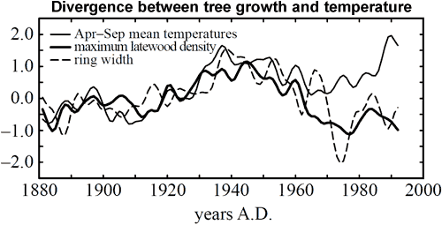
Who said the MWP disappeared? It still is quite apparent in other proxies. The "hide the decline" you are talking about only concerned tree ring data from high latitudes after 1960. It had no effect on proxies for prior periods. The problem was that there was decline in the correlation between that data and data obtained directly from instrumentation. Prior to that it was fairly consistent. After that, something happened. The high latitude tree growth did not reflect the actual temperatures which were known to be occurring. The tree proxies went wonky.
The MWP only disappeared because of data provided by "hide the decline" micheal Mann.
edit on 6/25/2016 by Phage because: (no reason given)
a reply to: Phage
So I should just accept that tree data went wonky only in the 1960s but it wasn't wonky in the first place? Really????
You are really trying to tell me that tree data was accurate for a thousand years before it went wonky - how stupid do you think I am!
The tree data didn't match up during the only time period when it could be compared to actual data - the logical conclusion is that the tree data was NEVER accurate.
As for differences between the north and south hemispheres - I am very tired of hearing spin. We are not observing global warming. We are seeing hemispheric warming.
Tired of Control Freaks
a reply to: TiredofControlFreaks
Ok.
It correlated quite well with other proxies. You know, the ones that show the MWP?
You are really trying to tell me that tree data was accurate for a thousand years before it went wonky - how stupid do you think I am!
The tree data didn't match up during the only time period when it could be compared to actual data - the logical conclusion is that the tree data was NEVER accurate.
Ok.
We are not observing global warming. We are seeing hemispheric warming.
edit on 6/25/2016 by Phage because: (no reason given)
a reply to: Phage
Am i to conclude that the MWP existed, and that it was, at least, as global as current warming
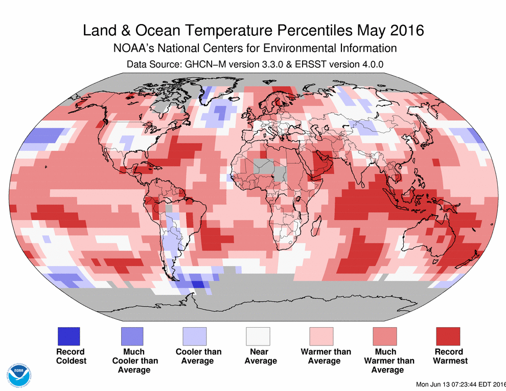
as for the graphs you have provided, they are from May 2015, and temperatures are being deeply affected by El Nino. The graphs are the result of a weather event, not climate.
Tired of Control Freaks
Am i to conclude that the MWP existed, and that it was, at least, as global as current warming
as for the graphs you have provided, they are from May 2015, and temperatures are being deeply affected by El Nino. The graphs are the result of a weather event, not climate.
Tired of Control Freaks
a reply to: TiredofControlFreaks
As far as sea surface temperatures go, El Nino is an eastern (mostly central) Pacific phenomenon but choose any period you wish. Annual, monthly, quarterly. Are you claiming that global, and hemispheric temperatures are not increasing?
www.ncdc.noaa.gov...
You can conclude whatever you will. I did ask for evidence showing that conditions were exactly the same during the MWP as they are now, as you claimed. Still waiting.
Am i to conclude that the MWP existed, and that it was, at least, as global as current warming
as for the graphs you have provided, they are from May 2015, and temperatures are being deeply affected by El Nino. The graphs are the result of a weather event, not climate.
As far as sea surface temperatures go, El Nino is an eastern (mostly central) Pacific phenomenon but choose any period you wish. Annual, monthly, quarterly. Are you claiming that global, and hemispheric temperatures are not increasing?
www.ncdc.noaa.gov...
edit on 6/25/2016 by Phage because: (no reason given)
edit on 6/25/2016 by Phage because: (no reason given)
More climate change for you deniers to deny
Apparently the region just received half its annual rainfall in a single day. Oh Shenandoah, I love to hear you... But not so much right now, I’ll bet.
Apparently the region just received half its annual rainfall in a single day. Oh Shenandoah, I love to hear you... But not so much right now, I’ll bet.
edit on 25/6/16 by Astyanax because: of floodwater.
a reply to: Astyanax
My sympathies to the people of West Virginia and their suffering
However, this is an example of weather, not global warming
West Virginia occasionally floods and has a history of doing so.
www.floodsafety.noaa.gov...
November 1985
February 1957
August 1943
abc7.com...
Weather is still not climate change (as devotees of climate change love to point out to deniers of climate change
Tired of Control Freaks
My sympathies to the people of West Virginia and their suffering
However, this is an example of weather, not global warming
West Virginia occasionally floods and has a history of doing so.
www.floodsafety.noaa.gov...
November 1985
he Cheat and Greenbrier rivers crested at record levels. Record water heights were also seen on portions of the Tygart Valley, Little Kanawha, and West Fork rivers, and on the north and south Branches of the Potomac. At Parsons, the Cheat River crested 10 feet above flood stage and 4 feet higher than the previous record from July 1888. At Glenville, the Little Kanawha River crested 13 feet above flood stage and about 2 feet higher than the March 1967 flood. At Philippi, the Tygart Valley River crested nearly 15 feet above flood stage, around 4 feet higher than the previous record stage. At Moorefield, the South Branch of the Potomac River crested about 10 feet above flood stage and nearly 4 feet higher than June 1949, the previous record. There were 47 deaths in West Virginia from the flood of 1985. Pendleton and Grant counties had the most fatalities. Towns such as Parsons, Rowlesburg, Philippi, Marlinton, Glenville, Petersburg, and Moorefield were severely damaged. The 1985 flood caused an estimated $570 million in damages. More than 3,500 homes and 180 businesses were destroyed.
February 1957
In February of 1957, heavy rains caused disastrous floods in southwest Virginia, eastern Kentucky and southern West Virginia. A dozen people died in the region, and thousands lost their homes. President Dwight Eisenhower declared 28 Appalachian counties disaster areas, and the National Guard was called in to help. Einsenhower called the 1957 flood the worst in almost 100 years.
August 1943
A notable flood of short duration and high intensity occurred during the night of August 4-5, 1943, in central West Virginia. The affected area was about 50 miles long and 10 miles wide in the diamond-shaped Kanawha River Basin, with elevations generally ranging from about EL 600 to EL 1500 (Figure below). Point rainfall amounted to as much as 15 inches in 2 hours. According to the U.S. Weather Bureau (1943), the record-breaking rains were accompanied by “one of the worst, if not the worst, electrical storms of record.” There were 23 deaths due to the flood, all of whom lived along relatively small tributaries. Six precipitation gages in the area recorded rainfall depths of only 0.31 inches to 5.0 inches, failing to provide a complete picture of the scattered intense rainfall pockets in the area. Representatives of the Corps of Engineers, the Weather Bureau, and the West Penn Power Company thoroughly investigated the storm, interviewing local residents and obtaining an additional 118 data points from the amount of water collected in pails, tubs, jars and other containers that were uncovered and open during the storm.
abc7.com...
Weather is still not climate change (as devotees of climate change love to point out to deniers of climate change
Tired of Control Freaks
a reply to: TiredofControlFreaks
Thank you for your contribution to this thread. I think you have done more to convince others of the reality of climate change than I could possibly have done. The more you thrash about, the more you reveal the truth.
Thank you for your contribution to this thread. I think you have done more to convince others of the reality of climate change than I could possibly have done. The more you thrash about, the more you reveal the truth.
a reply to: Astyanax
thanks for trying to insult me. When people can't refute the message, they try to insult the messenger instead.
hot in India during the spring - must be climate change. happens every year but now its different
flooding in texas and west virginia - proof of climate change. happened before but now its different
forest fires in Canada - proof of climate change. happened before but now its different
drought in California - proof of climate change. happened before but its different.
MWP as hot or hotter than current temperatures - that's different!
hemispheric warming - no its really global because now its different
30 years of warming is significant - but not when its the MWP because now its different
Don't use weather as proof of climate - unless you are trying to prove its climate change, then its ok because now its different.
You people argue out of both sides of your mouth and hate getting called out on it!
Tired of Control Freaks
new topics
-
Remember These Attacks When President Trump 2.0 Vengeance-Retribution Commences.
2024 Elections: 34 minutes ago -
Predicting The Future: The Satanic Temple v. Florida
Conspiracies in Religions: 42 minutes ago -
WF Killer Patents & Secret Science Vol. 1 | Free Energy & Anti-Gravity Cover-Ups
General Conspiracies: 2 hours ago -
Hurt my hip; should I go see a Doctor
General Chit Chat: 3 hours ago -
Israel attacking Iran again.
Middle East Issues: 4 hours ago -
Michigan school district cancels lesson on gender identity and pronouns after backlash
Education and Media: 4 hours ago -
When an Angel gets his or her wings
Religion, Faith, And Theology: 5 hours ago -
Comparing the theology of Paul and Hebrews
Religion, Faith, And Theology: 6 hours ago -
Pentagon acknowledges secret UFO project, the Kona Blue program | Vargas Reports
Aliens and UFOs: 7 hours ago -
Boston Dynamics say Farewell to Atlas
Science & Technology: 7 hours ago
top topics
-
The Democrats Take Control the House - Look what happened while you were sleeping
US Political Madness: 10 hours ago, 18 flags -
In an Historic First, In N Out Burger Permanently Closes a Location
Mainstream News: 12 hours ago, 16 flags -
Biden says little kids flip him the bird all the time.
Politicians & People: 10 hours ago, 9 flags -
Man sets himself on fire outside Donald Trump trial
Mainstream News: 10 hours ago, 9 flags -
Michigan school district cancels lesson on gender identity and pronouns after backlash
Education and Media: 4 hours ago, 7 flags -
WF Killer Patents & Secret Science Vol. 1 | Free Energy & Anti-Gravity Cover-Ups
General Conspiracies: 2 hours ago, 6 flags -
Pentagon acknowledges secret UFO project, the Kona Blue program | Vargas Reports
Aliens and UFOs: 7 hours ago, 6 flags -
Israel attacking Iran again.
Middle East Issues: 4 hours ago, 5 flags -
Boston Dynamics say Farewell to Atlas
Science & Technology: 7 hours ago, 4 flags -
Remember These Attacks When President Trump 2.0 Vengeance-Retribution Commences.
2024 Elections: 34 minutes ago, 3 flags
active topics
-
Remember These Attacks When President Trump 2.0 Vengeance-Retribution Commences.
2024 Elections • 5 • : budzprime69 -
MULTIPLE SKYMASTER MESSAGES GOING OUT
World War Three • 55 • : annonentity -
Predicting The Future: The Satanic Temple v. Florida
Conspiracies in Religions • 5 • : Degradation33 -
Israel attacking Iran again.
Middle East Issues • 28 • : KrustyKrab -
In an Historic First, In N Out Burger Permanently Closes a Location
Mainstream News • 11 • : TheMisguidedAngel -
Michigan school district cancels lesson on gender identity and pronouns after backlash
Education and Media • 9 • : TheMisguidedAngel -
Mood Music Part VI
Music • 3064 • : MRTrismegistus -
Man sets himself on fire outside Donald Trump trial
Mainstream News • 41 • : TheMisguidedAngel -
The New, New ATS Members Photos thread. Part 3.
Members • 1653 • : zosimov -
A man of the people
Medical Issues & Conspiracies • 15 • : PrivateAngel