It looks like you're using an Ad Blocker.
Please white-list or disable AboveTopSecret.com in your ad-blocking tool.
Thank you.
Some features of ATS will be disabled while you continue to use an ad-blocker.

Major severe weather outbreak in the southern plains - 04/26/2016 - 04/29/2016
page: 10share:
a reply to: SonOfThor
My apologies...It must've been an error because they showed it again and it was back to orange. But if it upgrades to red then I will post with a link! (I originally saw it on Fox4 news with Evan the meteorologist)
The timeline is supposed to be between and 5 and 6pm but, of course, it could change.
a reply to: texasgirl
It may very well move to a moderate risk, within the next thirty mins... The model data is fairly wide spread showing rotating supercells, these will not congeal into a squall so the individual cells will have more instability to work with.. When I get more time I will do a write up. Today may just be the day when the threat of this weeks volatility are realized.
It may very well move to a moderate risk, within the next thirty mins... The model data is fairly wide spread showing rotating supercells, these will not congeal into a squall so the individual cells will have more instability to work with.. When I get more time I will do a write up. Today may just be the day when the threat of this weeks volatility are realized.
Tornado watch issued all of north Texas...
Tornado Watch TORNADO WATCH OUTLINE UPDATE FOR WT 124 NWS STORM PREDICTION CENTER NORMAN OK 105 PM CDT FRI APR 29 2016 TORNADO WATCH 124 IS IN EFFECT UNTIL 1000 PM CDT FOR THE FOLLOWING LOCATIONS TXC001-027-035-085-093-097-099-113-119-121-139-143-145-147-161- 181-193-213-217-221-223-231-251-257-277-281-289-293-309-331-333- 337-349-367-379-395-397-425-439-467-497-300300- /O.NEW.KWNS.TO.A.0124.160429T1805Z-160430T0300Z/ TX . TEXAS COUNTIES INCLUDED ARE ANDERSON BELL BOSQUE COLLIN COMANCHE COOKE CORYELL DALLAS DELTA DENTON ELLIS ERATH FALLS FANNIN FREESTONE GRAYSON HAMILTON HENDERSON HILL HOOD HOPKINS HUNT JOHNSON KAUFMAN LAMAR LAMPASAS LEON LIMESTONE MCLENNAN MILAM MILLS MONTAGUE NAVARRO PARKER RAINS ROBERTSON ROCKWALL SOMERVELL TARRANT VAN ZANDT WISE $$ ATTN...WFO...FWD...
originally posted by: TechniXcality
a reply to: texasgirl
It may very well move to a moderate risk, within the next thirty mins... The model data is fairly wide spread showing rotating supercells, these will not congeal into a squall so the individual cells will have more instability to work with.. When I get more time I will do a write up. Today may just be the day when the threat of this weeks volatility are realized.
I wonder how many people are going to write today's forecast off since Tuesday didn't really measure up to all the hype.
a reply to: texasgirl
Good point...
While I could see the models showing a very volatile week this week, it is always difficult to nail down the mescoscale features but i believe today is the day to be on the watch..
and they should NOT take this any lighter than Tuesday, here's a discussion just issues by NWS here in the Dallas area emphasis mine..
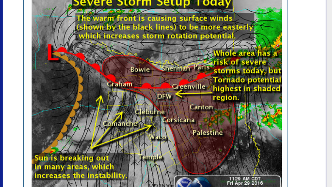
A VERY MOIST AND UNSTABLE ENVIRONMENT WILL COINCIDE WITH STRONGAFTERNOON HEATING TO PRODUCE A VERY UNSTABLE ENVIRONMENT ACROSS THE WARM SECTOR THIS MORNING. IN ADDITION...LARGE SCALE ASCENT WILL INCREASE BY 2 PM CDT AND AFTER FOR THE RAPID DEVELOPMENT OF SEVERE STORMS ALONG OR JUST WEST OF I-35 IN AN AREA OF ENHANCED ISENTROPIC ASCENT. INITIALLY...DISCRETE SUPERCELL THUNDERSTORMS WITH LOW LCL/S WILL BE POSSIBLE...AS SURFACE DEW PT TEMPERATURES ARE HIGH AND IN THE LOWER-MID 70S WITHIN THE WARM SECTOR. ALL MODES OF SEVERE WEATHER WILL BE POSSIBLE. THE BIG WILD CARD LATER IN THE AFTERNOON AND EVENING WILL BE HOW LONG DISCRETE STORMS WILL OCCUR...AS LARGE-SCALE ASCENT OCCURS QUICKLY AT CONVECTIVE TEMPERATURE AND MAY RESULT IN INFLOW INTERRUPTION WITH IF STORMS BECOME MORE WIDESPREAD SOONER. IF ACTIVITY BECOMES TOO WIDESPREAD TOO FAST...THEN DISCRETE SUPERCELLS WILL BE LESS LIKELY. HOWEVER...BOWING LINE SEGMENTS OR LEWPS WITH TORNADOES WILL BE POSSIBLE INTO THE EVENING HOURS DUE TO VERY STRONG LOW LEVEL WINDS AND DEEP LAYER SHEAR ACROSS THE AREA WITH CURVED LOW LEVEL HODOGRAPHS NOTED ON FORCAST SOUNDSING. VERY LARGE HAIL WILL ALSO BE POSSIBLE...ESPECIALLY WITH DISCRETE CELLS AS INSTABILITY WILL BE PUSHING BETWEEN 3000-4000 J/KG WITH PLENTY OF LOW LEVEL CAPE BELOW CLOUD BASE FOR POTENTIAL TORNADOGENESIS. SEVERAL OFFICES INCLUDING OURS ARE SENDING UP SPECIAL MIDDAY SOUNDINGS TO ASSESS OUR ENVIRONMENT AND POTENTIAL AND THE FEELING IS THIS COULD BE A BIG SEVERE WEATHER DAY.
edit on 29-4-2016 by TechniXcality because: (no reason given)
a reply to: TechniXcality
I just got home from Plano and thought the sky was rather dark there. The heat was oppressive!!
Sure enough, there's a small pocket of storms going through there. I also see a long line forming around Stephenville, southwest of Dallas.
I just got home from Plano and thought the sky was rather dark there. The heat was oppressive!!
Sure enough, there's a small pocket of storms going through there. I also see a long line forming around Stephenville, southwest of Dallas.
NWS discussion
000 FXUS64 KFWD 291822 AAD AFDFWD AREA FORECAST DISCUSSION...UPDATED NATIONAL WEATHER SERVICE FORT WORTH TX 122 PM CDT FRI APR 29 2016 .UPDATE... TORNADO WATCH 124 HAS BEEN ISSUED FOR ALL BUT JACK...PALO PINTO... EASTLAND...STEPHENS AND YOUNG COUNTIES THROUGH 03Z/10 PM CDT THIS EVENING. AS NOTED ON MY EARLIER DISCUSSION...THE ENVIRONMENT IS RIPE WITH MOISTURE/SHEAR/AND INSTABILITY FOR ALL MODES OF SEVERE WEATHER...INCLUDING A FEW TORNADOES. ALL INTERESTS WITHIN THE WATCH AREA SHOULD BE PREPARED FOR SEVERE WEATHER FROM NOW THROUGH MID EVENING. STORMS MAY BE INITIALLY DISCRETE IN NATURE AS LARGE-SCALE ASCENT APPROACHES DURING PRIME AFTERNOON HEATING AND IN THE FORM OF SUPERCELLS. BY EARLY EVENING...STORMS SHOULD MORPH INTO BOWING LINE SEGMENTS OR A BROKEN SQUALL LINE MOVING THROUGH AREAS EAST OF I-35/35E. EVEN SO...MESO-LOW TYPE TORNADOES WILL STILL BE POSSIBLE GIVEN THE HIGH SURFACE DEW PTS AND LOW LCL/S. IN ADDITION...LARGE HAIL AND DAMAGING WINDS WILL BE THREATS. LOCALIZED FLASH FLOODING WILL BE POSSIBLE ALONG AND EAST OF A BONHAM...ROCKWALL...CORSICANA TO HEARNE LINE WHERE 1-2 INCHES WITH ISOLATED 3 INCH AMOUNTS WILL BE POSSIBLE THROUGH THIS EVENING. IT/S A LITTLE LATE IN THE GAME FOR ANY FLASH FLOOD WATCHES...BUT THESE AREAS WILL NEED TO WATCHED FOR HYDROLOGIC WARNINGS IN ADDITION TO SEVERE WEATHER WARNINGS...INCLUDING TORNADOES.
a reply to: TechniXcality
Is this type of environment conducive to long track / extremely large tornadoes, or is that something that is still difficult to predict?
FYI FOR ANYONE TRAVELING ON I-20 Westbound, right around 360 the entire west bound lanes were totally closed down (all lanes) from a tractor trailer wreck earlier. Please be aware the traffic is still bad there for your commutes home / with these pending storms...
Stay safe! I'll keep everyone posted on what I see on my drive home (high overpasses so good vantage points).
a reply to: SonOfThor
tornadoes are likely however long track tornadoes do not appear likely at this time two things, first if these clusters of storm continue to fire and become very numerous and wide spread it will diminish some of the threat because the instability will be used up, also it now appears after these storms firing this evening will form into a squall line west of Ft Worth and move through the area, however tornadoes do appear likely.
tornadoes are likely however long track tornadoes do not appear likely at this time two things, first if these clusters of storm continue to fire and become very numerous and wide spread it will diminish some of the threat because the instability will be used up, also it now appears after these storms firing this evening will form into a squall line west of Ft Worth and move through the area, however tornadoes do appear likely.
edit on 29-4-2016 by TechniXcality because: (no reason given)
Tornado warning near Sherman and a little north of Howe. This is almost same place as Tuesday's tornado. Yikes!
This is actually along Interstate 75. Good grief, people are leaving work now!
This is actually along Interstate 75. Good grief, people are leaving work now!
edit on 29-4-2016 by texasgirl because: (no reason
given)
a reply to: texasgirl
Drove home along 287 N, and just off to my west was some seriously dark and low clouds heading up toward Ft. Worth. Didn't see any rotation though, just lots of rain.
For those meteorological types - on my whole drive home the air just looked hazy underneath the thick overcast. Does that have something to do with why the cell hitting Ft. Worth doesn't have any real indication for tornadic activity?
Tornado Warning
TORNADO WARNING
TXC035-292345-
/O.NEW.KFWD.TO.W.0028.160429T2308Z-160429T2345Z/
BULLETIN - EAS ACTIVATION REQUESTED
TORNADO WARNING
NATIONAL WEATHER SERVICE FORT WORTH TX
608 PM CDT FRI APR 29 2016
THE NATIONAL WEATHER SERVICE IN FORT WORTH HAS ISSUED A
* TORNADO WARNING FOR...
CENTRAL BOSQUE COUNTY IN CENTRAL TEXAS...
* UNTIL 645 PM CDT
* AT 608 PM CDT...A SEVERE THUNDERSTORM CAPABLE OF PRODUCING A TORNADO
WAS LOCATED NEAR MERIDIAN STATE PARK...OR 16 MILES NORTHWEST OF
CLIFTON...MOVING NORTHEAST AT 25 MPH.
HAZARD...TORNADO AND HAIL UP TO TWO INCHES IN DIAMETER.
SOURCE...RADAR INDICATED ROTATION.
IMPACT...FLYING DEBRIS WILL BE DANGEROUS TO THOSE CAUGHT WITHOUT
SHELTER. MOBILE HOMES WILL BE DAMAGED OR DESTROYED.
DAMAGE TO ROOFS...WINDOWS...AND VEHICLES WILL OCCUR. TREE
DAMAGE IS LIKELY.
* THIS DANGEROUS STORM WILL BE NEAR...
MERIDIAN AROUND 620 PM CDT.
OTHER LOCATIONS IMPACTED BY THIS TORNADIC THUNDERSTORM INCLUDE WALNUT
SPRINGS AND MORGAN.
PRECAUTIONARY/PREPAREDNESS ACTIONS...
TAKE COVER NOW! MOVE TO A BASEMENT OR AN INTERIOR ROOM ON THE LOWEST
FLOOR OF A STURDY BUILDING. AVOID WINDOWS. IF YOU ARE OUTDOORS...IN A
MOBILE HOME...OR IN A VEHICLE...MOVE TO THE CLOSEST SUBSTANTIAL SHELTER
AND PROTECT YOURSELF FROM FLYING DEBRIS.
&&
LAT...LON 3193 9794 3220 9760 3217 9760 3218 9757
3215 9757 3213 9752 3216 9751 3214 9748
3213 9750 3210 9747 3206 9749 3202 9749
3201 9747 3203 9743 3199 9741 3198 9738
3193 9744 3192 9743 3180 9785
TIME...MOT...LOC 2308Z 234DEG 21KT 3195 9778
TORNADO...RADAR INDICATED
HAIL...2.00IN
$$
TORNADO WARNING
TXC035-292345-
/O.NEW.KFWD.TO.W.0028.160429T2308Z-160429T2345Z/
BULLETIN - EAS ACTIVATION REQUESTED
TORNADO WARNING
NATIONAL WEATHER SERVICE FORT WORTH TX
608 PM CDT FRI APR 29 2016
THE NATIONAL WEATHER SERVICE IN FORT WORTH HAS ISSUED A
* TORNADO WARNING FOR...
CENTRAL BOSQUE COUNTY IN CENTRAL TEXAS...
* UNTIL 645 PM CDT
* AT 608 PM CDT...A SEVERE THUNDERSTORM CAPABLE OF PRODUCING A TORNADO
WAS LOCATED NEAR MERIDIAN STATE PARK...OR 16 MILES NORTHWEST OF
CLIFTON...MOVING NORTHEAST AT 25 MPH.
HAZARD...TORNADO AND HAIL UP TO TWO INCHES IN DIAMETER.
SOURCE...RADAR INDICATED ROTATION.
IMPACT...FLYING DEBRIS WILL BE DANGEROUS TO THOSE CAUGHT WITHOUT
SHELTER. MOBILE HOMES WILL BE DAMAGED OR DESTROYED.
DAMAGE TO ROOFS...WINDOWS...AND VEHICLES WILL OCCUR. TREE
DAMAGE IS LIKELY.
* THIS DANGEROUS STORM WILL BE NEAR...
MERIDIAN AROUND 620 PM CDT.
OTHER LOCATIONS IMPACTED BY THIS TORNADIC THUNDERSTORM INCLUDE WALNUT
SPRINGS AND MORGAN.
PRECAUTIONARY/PREPAREDNESS ACTIONS...
TAKE COVER NOW! MOVE TO A BASEMENT OR AN INTERIOR ROOM ON THE LOWEST
FLOOR OF A STURDY BUILDING. AVOID WINDOWS. IF YOU ARE OUTDOORS...IN A
MOBILE HOME...OR IN A VEHICLE...MOVE TO THE CLOSEST SUBSTANTIAL SHELTER
AND PROTECT YOURSELF FROM FLYING DEBRIS.
&&
LAT...LON 3193 9794 3220 9760 3217 9760 3218 9757
3215 9757 3213 9752 3216 9751 3214 9748
3213 9750 3210 9747 3206 9749 3202 9749
3201 9747 3203 9743 3199 9741 3198 9738
3193 9744 3192 9743 3180 9785
TIME...MOT...LOC 2308Z 234DEG 21KT 3195 9778
TORNADO...RADAR INDICATED
HAIL...2.00IN
$$
a reply to: TechniXcality
I'm watching this cell on the radar, where do we think it's headed in terms of DFW area? Kind of looks like between Waxahachie / Lancaster / DeSoto at the moment.
Is this still capable of tornadoes? Good friends live in Lancaster I need to give them a heads up
I'm watching this cell on the radar, where do we think it's headed in terms of DFW area? Kind of looks like between Waxahachie / Lancaster / DeSoto at the moment.
Is this still capable of tornadoes? Good friends live in Lancaster I need to give them a heads up
new topics
-
TLDR post about ATS and why I love it and hope we all stay together somewhere
General Chit Chat: 7 minutes ago -
Hate makes for strange bedfellows
US Political Madness: 2 hours ago -
Who guards the guards
US Political Madness: 4 hours ago -
Has Tesla manipulated data logs to cover up auto pilot crash?
Automotive Discussion: 6 hours ago -
whistleblower Captain Bill Uhouse on the Kingman UFO recovery
Aliens and UFOs: 11 hours ago
top topics
-
CIA botched its handling of sexual assault allegations, House intel report says
Breaking Alternative News: 16 hours ago, 11 flags -
whistleblower Captain Bill Uhouse on the Kingman UFO recovery
Aliens and UFOs: 11 hours ago, 10 flags -
Hate makes for strange bedfellows
US Political Madness: 2 hours ago, 9 flags -
Who guards the guards
US Political Madness: 4 hours ago, 8 flags -
1980s Arcade
General Chit Chat: 13 hours ago, 5 flags -
Teenager makes chess history becoming the youngest challenger for the world championship crown
Other Current Events: 15 hours ago, 4 flags -
Deadpool and Wolverine
Movies: 14 hours ago, 4 flags -
Has Tesla manipulated data logs to cover up auto pilot crash?
Automotive Discussion: 6 hours ago, 2 flags -
TLDR post about ATS and why I love it and hope we all stay together somewhere
General Chit Chat: 7 minutes ago, 0 flags
active topics
-
Candidate TRUMP Now Has Crazy Judge JUAN MERCHAN After Him - The Stormy Daniels Hush-Money Case.
Political Conspiracies • 689 • : matafuchs -
Hate makes for strange bedfellows
US Political Madness • 17 • : ImagoDei -
SC Jack Smith is Using Subterfuge Tricks with Donald Trumps Upcoming Documents Trial.
Dissecting Disinformation • 102 • : Threadbarer -
Russia Ukraine Update Thread - part 3
World War Three • 5714 • : stu119 -
TLDR post about ATS and why I love it and hope we all stay together somewhere
General Chit Chat • 0 • : SideEyeEverything1 -
How ageing is" immune deficiency"
Medical Issues & Conspiracies • 27 • : RookQueen2 -
whistleblower Captain Bill Uhouse on the Kingman UFO recovery
Aliens and UFOs • 14 • : alldaylong -
"We're All Hamas" Heard at Columbia University Protests
Social Issues and Civil Unrest • 234 • : KrustyKrab -
IDF Intel Chief Resigns Over Hamas attack
Middle East Issues • 42 • : TheWoker -
Deadpool and Wolverine
Movies • 4 • : FlyersFan