It looks like you're using an Ad Blocker.
Please white-list or disable AboveTopSecret.com in your ad-blocking tool.
Thank you.
Some features of ATS will be disabled while you continue to use an ad-blocker.

Major severe weather outbreak in the southern plains - 04/26/2016 - 04/29/2016
page: 7share:
In lawton ok, wind is a mix of cool and warm with some gusts strong enough to blow the trees gentley. Lots of cloud cover, so I guess we'll see what
happens with that.
It feels electric. I remember this from the late 90s. Going to go fishing and eat some beans.
It feels electric. I remember this from the late 90s. Going to go fishing and eat some beans.
Weather Underground
The strongest storms are expected in two zones:
one near a warm front that will be moving slowly north across northeast Kansas and northern Missouri toward southern Nebraska,
and the other along and ahead of a dry line that should be located roughly 50-100 miles west of the Dallas-Fort Worth, Oklahoma City, and Wichita areas by late afternoon.
--The vertical wind structure of the atmosphere is not ideal for a widespread tornado outbreak. Although winds do strengthen with height, and upper-level winds are somewhat stronger than expected, the upper-level storm moving into the Plains has dug far enough south that winds will have a strong southerly component at all levels.
This reduces the amount of directional shear (variation of wind direction with height) that can help enhance storm rotation.
In addition, storms that are moving parallel to the dry line will tend to coalesce more quickly over time, rather than being more scattered or isolated supercell storms. Still, there will be local variations in the wind profile, so tornadic supercells are a distinct possibility, including the potential for strong tornadoes.
a reply to: TechniXcality
Wichita has shifted the long-track threat south more back down into your neck of the woods. Any long -track tornado threat for Kansas now exists if discrete super cells come up in the later evening hours from Oklahoma.
Current severe threats in Kansas are more short-term and straight line, but still very real and high.
Tornado watch north Texas
Until midnight..
Until midnight..
TORNADO WATCH OUTLINE UPDATE FOR WT 109 NWS STORM PREDICTION CENTER NORMAN OK 230 PM CDT TUE APR 26 2016 TORNADO WATCH 109 IS IN EFFECT UNTIL 1200 AM CDT FOR THE FOLLOWING LOCATIONS TXC009-023-035-049-059-077-081-083-085-093-095-097-113-121-133- 139-143-147-151-181-193-207-217-221-231-237-251-253-257-275-307- 333-337-353-363-367-397-399-411-417-425-429-439-441-447-451-485- 487-497-503-270500- /O.NEW.KWNS.TO.A.0109.160426T1930Z-160427T0500Z/ TX . TEXAS COUNTIES INCLUDED ARE ARCHER BAYLOR BOSQUE BROWN CALLAHAN CLAY COKE COLEMAN COLLIN COMANCHE CONCHO COOKE DALLAS DENTON EASTLAND ELLIS ERATH FANNIN FISHER GRAYSON HAMILTON HASKELL HILL HOOD HUNT JACK JOHNSON JONES KAUFMAN KNOX MCCULLOCH MILLS MONTAGUE NOLAN PALO PINTO PARKER ROCKWALL RUNNELS SAN SABA SHACKELFORD SOMERVELL STEPHENS TARRANT TAYLOR THROCKMORTON TOM GREEN WICHITA WILBARGER WISE YOUNG $$ ATTN...WFO...OUN...FWD...SJT...TSA...
edit on 26-4-2016 by TechniXcality because: (no reason given)
a reply to: TechniXcality
PDS watch as anticipated...
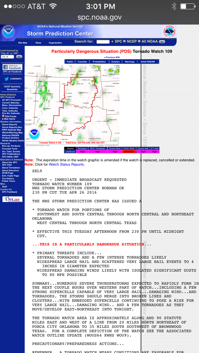
PDS watch as anticipated...
* EFFECTIVE THIS TUESDAY AFTERNOON FROM 230 PM UNTIL MIDNIGHT CDT. ...THIS IS A PARTICULARLY DANGEROUS SITUATION... * PRIMARY THREATS INCLUDE... SEVERAL TORNADOES AND A FEW INTENSE TORNADOES LIKELY WIDESPREAD LARGE HAIL AND SCATTERED VERY LARGE HAIL EVENTS TO 4 INCHES IN DIAMETER EXPECTED WIDESPREAD DAMAGING WINDS LIKELY WITH ISOLATED SIGNIFICANT GUSTS TO 80 MPH POSSIBLE
edit on 26-4-2016 by TechniXcality because: (no reason given)
Good information here guys. Thanks for the continued posting. I just received an email from the boss telling us to head out early to help minimize
any impacts to the drive home. I have a Hurst-to-Mansfield route that usually takes us right along any fronts that are moving through. Fun times
School & event closings in north Texas so far
LINK
LINK
The looming severe weather has forced several North Texas cities and school districts to cancel events or close off areas. See our list below: Carroll ISD: After-school events canceled Tuesday. Duncanville ISD: After-school activities canceled on Tuesday. Fort Worth ISD: Some baseball games are canceled and will be moved to Wednesday. The following games will still be played Tuesday and should be done by 7 p.m.: Lake Dallas plays at Dunbar High School at 3:45 p.m. Alvarado will play at Diamond Hill-Jarvis High School at 5 p.m. (originally 7 p.m.) Trimble Tech High School still travels to Arlington Heights High School – 5 p.m. (originally 7 p.m.) South Hills will face Southwest High School – 5 p.m. (originally 7 p.m.) Frisco ISD: All after-school and evening activities are canceled. AlphaBest and YMCA will continue as scheduled. Grand Prairie ISD: All middle school soccer games scheduled for Tuesday have been canceled due to the inclement weather forecast. Lewisville ISD: After-school and evening events and practices are canceled. District facilities and programs are still on schedule until 6:30 p.m. Lovejoy ISD: Middle school soccer games canceled and moved to Wednesday, April 27. Mansfield ISD: After-school and athletic activities canceled. After-school child care programs will go on as scheduled. The MISD school board meeting will be held at 6 p.m. at the MISD Center for Performing Arts. Northwest ISD: All evening activities have been canceled, including the Northwest ISD Art Show at the Administration Building. You can attend the show on April 28 at 6 p.m. Richardson ISD: Junior high soccer games canceled for Tuesday. City of Stephenville: City Park gates will close at 3 p.m. The Weatherford ISD posted the following policy for severe weat
a reply to: TechniXcality
Tornado warning near Wellington Kansas... First one of today...
Tornado warning near Wellington Kansas... First one of today...
TORNADO WARNING KSC191-262100- /O.NEW.KICT.TO.W.0006.160426T2013Z-160426T2100Z/ BULLETIN - EAS ACTIVATION REQUESTED TORNADO WARNING NATIONAL WEATHER SERVICE WICHITA KS 313 PM CDT TUE APR 26 2016 THE NATIONAL WEATHER SERVICE IN WICHITA HAS ISSUED A * TORNADO WARNING FOR... SOUTHWESTERN SUMNER COUNTY IN SOUTH CENTRAL KANSAS... * UNTIL 400 PM CDT * AT 313 PM CDT...A SEVERE THUNDERSTORM CAPABLE OF PRODUCING A TORNADO WAS LOCATED 8 MILES WEST OF CALDWELL...MOVING NORTHEAST AT 30 MPH. HAZARD...TORNADO AND HAIL UP TO TWO INCHES IN DIAMETER. SOURCE...RADAR INDICATED ROTATION. IMPACT...FLYING DEBRIS WILL BE DANGEROUS TO THOSE CAUGHT WITHOUT SHELTER. MOBILE HOMES WILL BE DAMAGED OR DESTROYED. DAMAGE TO ROOFS...WINDOWS...AND VEHICLES WILL OCCUR. TREE DAMAGE IS LIKELY. * THIS DANGEROUS STORM WILL BE NEAR... ARGONIA AROUND 340 PM CDT. OTHER LOCATIONS IMPACTED BY THIS TORNADIC THUNDERSTORM INCLUDE MAYFIELD...WELLINGTON AIRPORT...MILAN AND PERTH. # PRECAUTIONARY/PREPAREDNESS ACTIONS... TAKE COVER NOW! MOVE TO A BASEMENT OR AN INTERIOR ROOM ON THE LOWEST FLOOR OF A STURDY BUILDING. AVOID WINDOWS. IF YOU ARE OUTDOORS...IN A MOBILE HOME...OR IN A VEHICLE...MOVE TO THE CLOSEST SUBSTANTIAL SHELTER AND PROTECT YOURSELF FROM FLYING DEBRIS. && LAT...LON 3700 9780 3737 9780 3734 9735 3700 9765 TIME...MOT...LOC 2013Z 209DEG 26KT 3706 9775
Individual severe storms starting to fire up along the boundary created/pushed by the earlier round of severe weather that came through Kansas City.
They're wide enough apart they could be separate cells for a while.
edit on 26-4-2016 by ketsuko because: (no reason given)
Just to give everyone the link again here is the live stream storm chasers you can watch, I'm sure they will be getting busy very soon..
Live stream storm chasers
Live stream storm chasers

One of those north central KS storms is now warned.
This would be north of Emporia (I-35 runs through Emporia) right on highway 56.
edit on 26-4-2016 by ketsuko because: (no reason
given)
a reply to: TechniXcality
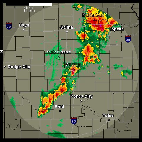
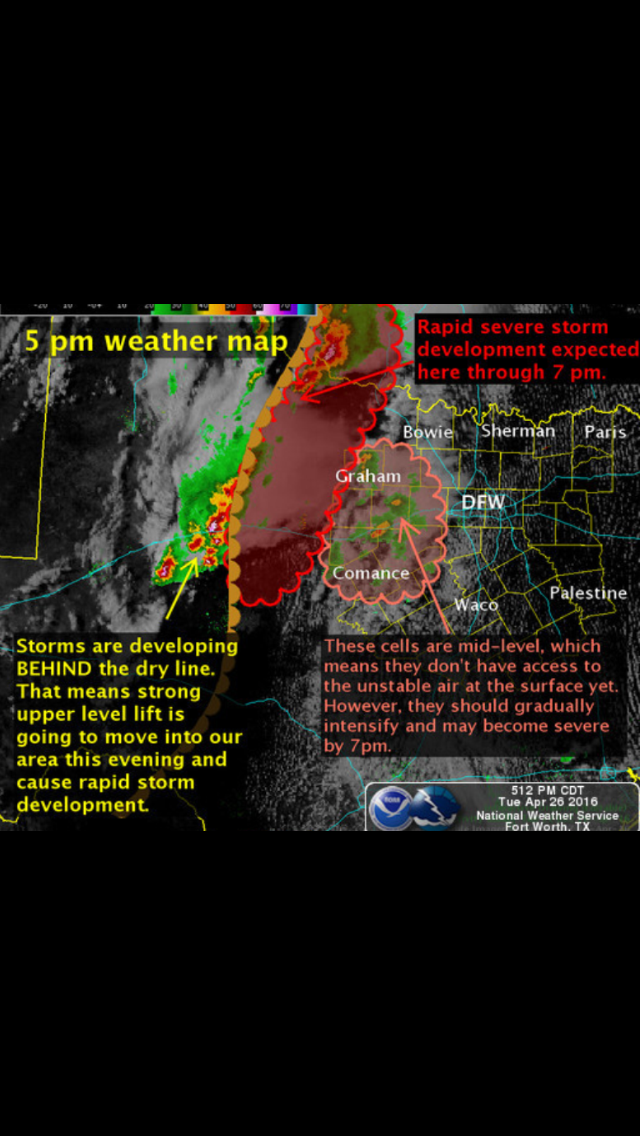
Graphic from 4:50 cst. showing the 1st tornado ob and extensions of severe wx into north Texas as well as the eastern progression.
Graphic from 4:50 cst. showing the 1st tornado ob and extensions of severe wx into north Texas as well as the eastern progression.
Radar indicated tornado in Shawnee County.
That's the east side of Topeka, KS, as the I-35 turnpike comes up along the city from the south.
Also looks like the storms are really starting to get busy in Oklahoma and Texas now.
That's the east side of Topeka, KS, as the I-35 turnpike comes up along the city from the south.
Also looks like the storms are really starting to get busy in Oklahoma and Texas now.
edit on 26-4-2016 by ketsuko because: west/east ... who's
counting?
new topics
-
Ditching physical money
History: 1 hours ago -
One Flame Throwing Robot Dog for Christmas Please!
Weaponry: 1 hours ago -
Don't take advantage of people just because it seems easy it will backfire
Rant: 1 hours ago -
VirginOfGrand says hello
Introductions: 2 hours ago -
Should Biden Replace Harris With AOC On the 2024 Democrat Ticket?
2024 Elections: 3 hours ago -
University student disciplined after saying veganism is wrong and gender fluidity is stupid
Education and Media: 5 hours ago -
Geddy Lee in Conversation with Alex Lifeson - My Effin’ Life
People: 6 hours ago -
God lived as a Devil Dog.
Short Stories: 6 hours ago -
Police clash with St George’s Day protesters at central London rally
Social Issues and Civil Unrest: 8 hours ago -
TLDR post about ATS and why I love it and hope we all stay together somewhere
General Chit Chat: 9 hours ago
top topics
-
Hate makes for strange bedfellows
US Political Madness: 11 hours ago, 18 flags -
Who guards the guards
US Political Madness: 14 hours ago, 13 flags -
University student disciplined after saying veganism is wrong and gender fluidity is stupid
Education and Media: 5 hours ago, 10 flags -
Police clash with St George’s Day protesters at central London rally
Social Issues and Civil Unrest: 8 hours ago, 8 flags -
TLDR post about ATS and why I love it and hope we all stay together somewhere
General Chit Chat: 9 hours ago, 7 flags -
Should Biden Replace Harris With AOC On the 2024 Democrat Ticket?
2024 Elections: 3 hours ago, 4 flags -
Has Tesla manipulated data logs to cover up auto pilot crash?
Automotive Discussion: 16 hours ago, 3 flags -
One Flame Throwing Robot Dog for Christmas Please!
Weaponry: 1 hours ago, 2 flags -
Don't take advantage of people just because it seems easy it will backfire
Rant: 1 hours ago, 2 flags -
Geddy Lee in Conversation with Alex Lifeson - My Effin’ Life
People: 6 hours ago, 2 flags
active topics
-
Ditching physical money
History • 7 • : TheMisguidedAngel -
BREAKING! Another Bridge Hit by a barge #3 this week.
Mainstream News • 110 • : RookQueen2 -
One Flame Throwing Robot Dog for Christmas Please!
Weaponry • 4 • : Dalamax -
15 Unhealthiest Sodas On The Market
Health & Wellness • 40 • : Freeborn -
Remember These Attacks When President Trump 2.0 Retribution-Justice Commences.
2024 Elections • 47 • : Zanti Misfit -
Breaking Baltimore, ship brings down bridge, mass casualties
Other Current Events • 469 • : firerescue -
Terrifying Encounters With The Black Eyed Kids
Paranormal Studies • 69 • : AlongCameaSpider -
Should Biden Replace Harris With AOC On the 2024 Democrat Ticket?
2024 Elections • 32 • : YourFaceAgain -
Candidate TRUMP Now Has Crazy Judge JUAN MERCHAN After Him - The Stormy Daniels Hush-Money Case.
Political Conspiracies • 739 • : WeMustCare -
My wife just had a very powerful prophetic dream - massive war in Israel...
The Gray Area • 16 • : AlongCameaSpider