It looks like you're using an Ad Blocker.
Please white-list or disable AboveTopSecret.com in your ad-blocking tool.
Thank you.
Some features of ATS will be disabled while you continue to use an ad-blocker.

Major severe weather outbreak in the southern plains - 04/26/2016 - 04/29/2016
page: 4share:
a reply to: ketsuko
No. Not really. Or maybe you should define "massive." 1011 mb does not really fit most definitions. Pretty mild actually. Notice the lack of isobars?
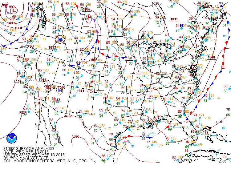
but there was a massive low sitting just north of us across the middle of the country.
No. Not really. Or maybe you should define "massive." 1011 mb does not really fit most definitions. Pretty mild actually. Notice the lack of isobars?
edit on 4/23/2016 by Phage because: (no reason given)
originally posted by: Phage
a reply to: TechniXcality
Why would anyone live there?
(Says a guy who lives in hurricane country)
Because... And you have a point my heart is set to the mountains in Colorado, (though obviously still not devoid of any severe weather) I lived in Texas most my life, cow tipping is fun ... The good thing about Texas for an avid weather enthusiast like myself is there's always something to watch.
a reply to: Phage
www.healthcentral.com...
Massive as in size of storm and length of time it took to crawl in and out of the area.
Honestly, I would never have pegged you for a science denier.
Now, it's possible both my neurologist and I are mistaken as to the correlation in my journals, but if so, aside from providing you a handy reason to scoff like the curmudgeon you are, it doesn't make any difference that I can see in your life, and I don't do anything to change my life except make sure I don't leave the house without my meds.
www.healthcentral.com...
Massive as in size of storm and length of time it took to crawl in and out of the area.
Ironically, we found the one constant in weather-triggered Migraines was change. For instance, even though the heat, high humidity or a storm can cause the headaches in some people, it's usually the change in temperature, humidity or barometric pressure that brings Migraines on in most sufferers."
Honestly, I would never have pegged you for a science denier.
Now, it's possible both my neurologist and I are mistaken as to the correlation in my journals, but if so, aside from providing you a handy reason to scoff like the curmudgeon you are, it doesn't make any difference that I can see in your life, and I don't do anything to change my life except make sure I don't leave the house without my meds.
a reply to: ketsuko
It wasn't a storm.
Massive as in size of storm and length of time it took to crawl in and out of the area.
I'm not. Your source:
Honestly, I would never have pegged you for a science denier.
Thus, more than 1 in 10 people in the study wrongly believed weather triggered their Migraines.
I've heard enough people mention their migraine
before a storm rolls in that I'm open to there being some
sort of correlation between weather, pressure changes, electrical storms
and migraines.
Have enough studies or a large enough sample
of the afflicted been done to put that to bed already ?
before a storm rolls in that I'm open to there being some
sort of correlation between weather, pressure changes, electrical storms
and migraines.
Have enough studies or a large enough sample
of the afflicted been done to put that to bed already ?
edit on 23-4-2016 by UnderKingsPeak because: grammar
a reply to: Phage
It was a low pressure area.
Yes, I don't think that any particular thunderstorm causes me to have a headache. It is the change in atmospheric pressure coupled with other things like humidity. Anytime we go from relatively high pressure to low pressure. The article also says that.
Now you are playing semantics, and I'm done arguing this in a thread not designed for it. If you want to continue calling me and my migraine specialists morons, start a thread in which you can do so and I'll come over there.
A graphic for you all regarding the Upper level disturbance position on Tuesday, which will come in as a "negative tilt" the most powerful storm
position, which will help create lift, and a severe weather outbreak across the plains. This is the European models forecast position.
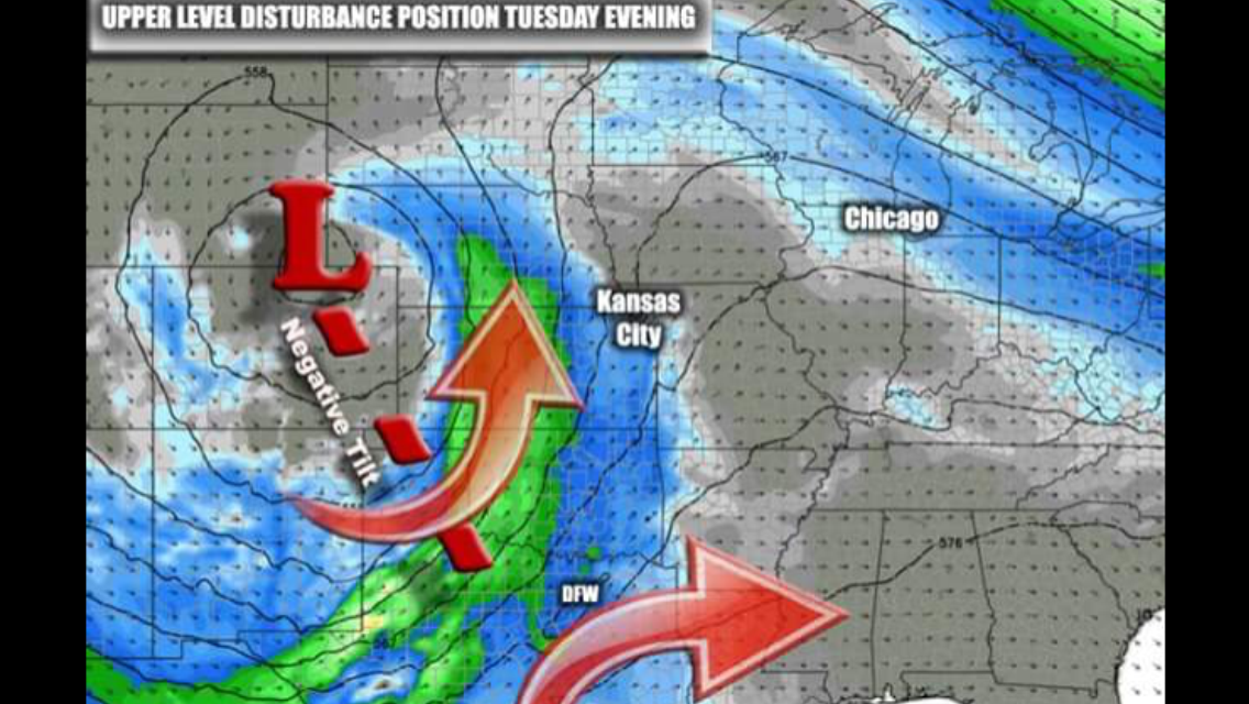
So models are trending towards agreement that Tuesday will in fact be the day to keep your eyes to the sky, of course this could change but this is the latest information.
So models are trending towards agreement that Tuesday will in fact be the day to keep your eyes to the sky, of course this could change but this is the latest information.
Local weather blog. This time they are talking
severe weather.
Still putting us in the late night hours which is typically wind and hail here, not tornados. They are advocating wait and see for us here since the data continues to change.
The main weather stories over the next 5 days will be 1) a weakening cold front that will slowly move through the KC region on Monday then quickly retreat northwards on Tuesday. 2) a potential upper level storm (and the reason for the quick retreat of the front) moving into the central Rockies Tuesday into the northern Plains on Wednesday 3) a BIG jump in surface dew points and eventual instability through the Plains. Strong surface moisture advection will be taking place sending dew points well into the 60s in the region later Tuesday into Wednesday AM 4) and outbreak of severe storms…timing of which is still a question for the KC area and elsewhere. The data today is already subtly different than yesterday and that will continue to be a trend through Monday at least. It appears the severe risk in KC is later Tuesday not earlier…and may even be pushed till later Tuesday night into early Wednesday. 5) there is still no way of telling how much severe weather will be an issue on the KC area…the timing changes already are showing up so there are more twists and turns coming I’m sure. Storms that fire well west of the area and get here after hours and in the middle of the night are typically wind/hail producers more than anything else…again let’s wait on this situation.
So with all the items above…wait and monitor approaches are the best. I’m already seeing some internet “chatter” about all sorts of terrible weather scenarios possible…and again how KC plays into that remains to be seen.
Still putting us in the late night hours which is typically wind and hail here, not tornados. They are advocating wait and see for us here since the data continues to change.
Saddle up! Here we go.
Tornado watches across central Kansas and northern Oklahoma.
Consider this the warm-up for the main event.

Tornado watches across central Kansas and northern Oklahoma.
NOAA's Storm Prediction Center has issued the following severe weather watches:
*A tornado watch is in effect until 11 p.m. CDT for central and eastern Kansas, as well as northern Oklahoma. The watch area includes Wichita, Kansas and Topeka, Kansas.
*A severe thunderstorm watch is valid until 10 p.m CDT for southeastern South Dakota, southwestern Minnesota, western Iowa, eastern Nebraska, north-central Kansas and far northwestern Missouri. The watch area includes Sioux Falls, South Dakota and Omaha, Nebraska.
Consider this the warm-up for the main event.
a reply to: ketsuko
Thank you for that... Today is just the beginning of a week of severe weather Tuesday appears to still be the most prominent wides spread threat... And then again Friday and Saturday, though Kansas will experience multiple rounds starting today, here is a radar depiction of Tuesday afternoon/evening over Texas, where supercells will explosively form and congeal into a squall line all modes of severe weather are possible, everyone stay safe we are in for s volatile ride over the next week.
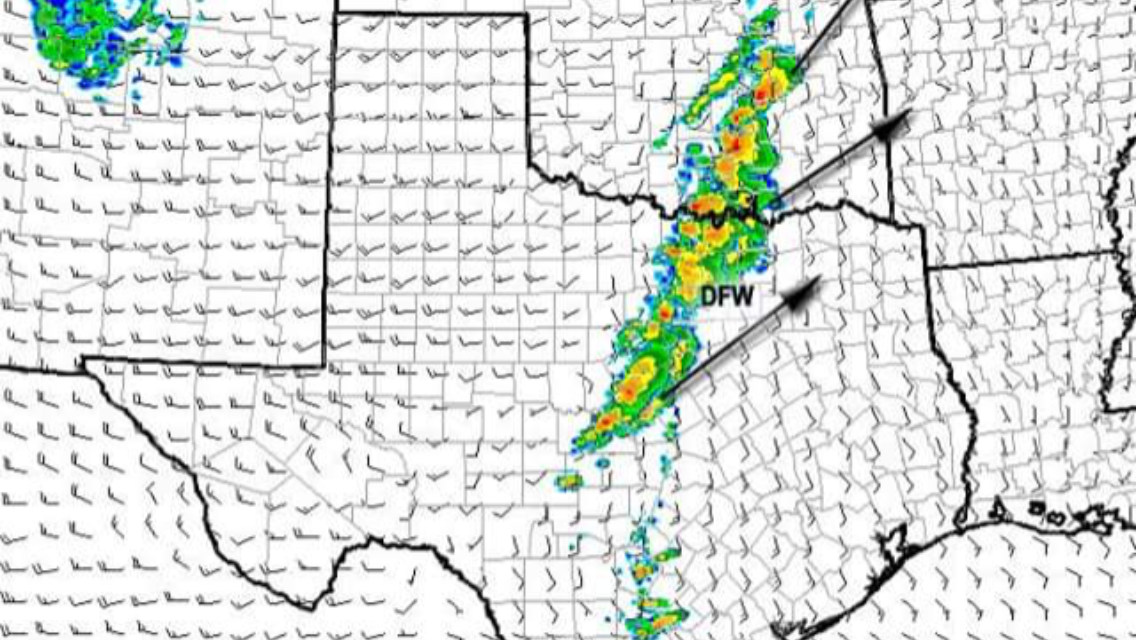
Thank you for that... Today is just the beginning of a week of severe weather Tuesday appears to still be the most prominent wides spread threat... And then again Friday and Saturday, though Kansas will experience multiple rounds starting today, here is a radar depiction of Tuesday afternoon/evening over Texas, where supercells will explosively form and congeal into a squall line all modes of severe weather are possible, everyone stay safe we are in for s volatile ride over the next week.
a reply to: TechniXcality
Even more concerning the NAM hi res has 3500 j/kg of CAPE and storms forming out ahead of the squall line, at around 11pm Tuesday night, this is looking like more and more of a dangerous situation as we get closer to Tuesdays event.
here the model depiction showing just that..
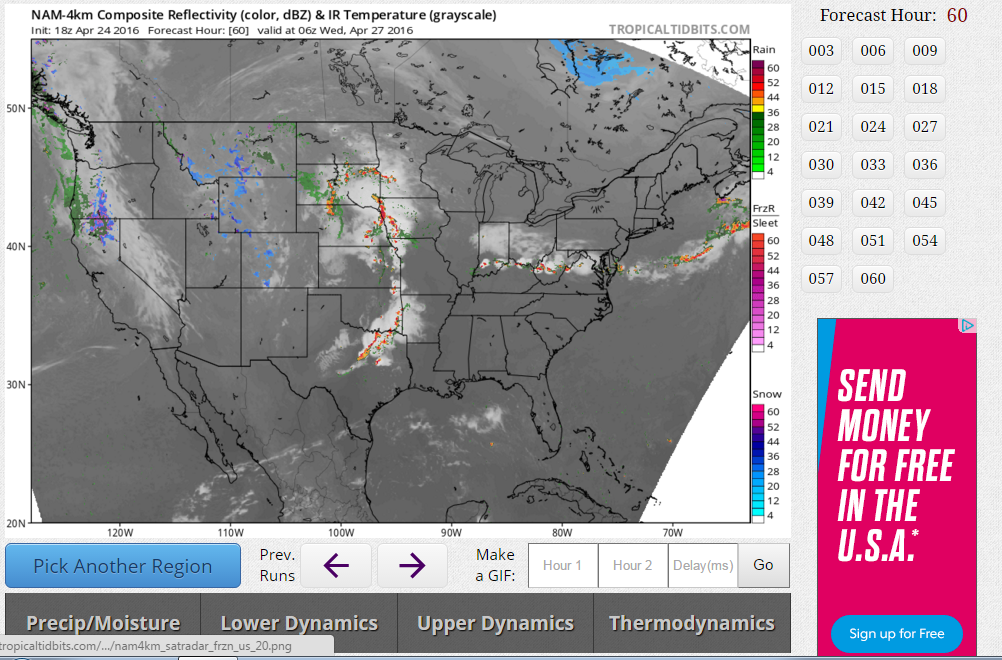
Even more concerning the NAM hi res has 3500 j/kg of CAPE and storms forming out ahead of the squall line, at around 11pm Tuesday night, this is looking like more and more of a dangerous situation as we get closer to Tuesdays event.
here the model depiction showing just that..
That big storm out in Kansas is right around my folks now, but it's not tornadic. When it was around Salina it was and my cousin is out in that area.
It was north of him though.
Here is a blog by profession MET Steve McCauley From his facebook page
LINK
LINK
New data coming in tonight seems to warrant our deep concern (though not fear) for Tuesday. Although according to this graphic the cap appears to be insurmountable on Tuesday morning, by late Tuesday afternoon it is altogether absent. These graphics depict a numerical value for cap strength. Without going into the boring details, a general rule of thumb is that when the cap strength exceeds a 100 points, it becomes very difficult to break. As you can see, our cap strength is between 250 and 400 points Tuesday morning across most of north Texas which is essentially unbreakable. But as daytime heating kicks in, and as our negative-tilt disturbance approaches, the cap will begin to rise, and the atmosphere will destabilize. You will recall that the cap is a layer of warm air aloft. When warm air is forced to rise, it must cool down (law of thermodynamics). Thus, when you force the cap to rise, it is forced to cool off. And when you cool the cap, you effectively get rid of it. This is why you see a large gaping open channel in the center of the cap from central Texas north into Kansas by Tuesday afternoon. It is through this breach in the cap that severe storms are expected to fire late in the day Tuesday and continuing into Tuesday evening. Note, there is no cap in west Texas. That is because the cap is irrelevant in areas that have no chance for storms. West Texas will be in the driest of desert air on Tuesday, so although technically there is "no cap," there can nevertheless be no storms, so cap strength is undefined in that area. Although Tuesday continues to be the big day to watch, tomorrow (Monday) will also need to be closely monitored for any unexpected weakness in the cap. The atmosphere will be very unstable on Monday, and a paper-thin cap may be the only thing that will stop supercell storms from popping. But it is hoped the cap will be just strong enough on Monday to prevent a "preview performance" of storms we will likely see late Tuesday
SPC is using very strong wording and has upgraded to moderate risk, would not be surprised if high risk is issued tomorrow..

SIGNIFICANT SEVERE THUNDERSTORMS WILL BE POSSIBLE ACROSS PARTS OF THE SOUTHERN AND CENTRAL GREAT PLAINS TUESDAY AFTERNOON INTO THE NIGHTTIME HOURS. TORNADOES...SOME STRONG...WILL BE POSSIBLE...IN ADDITION TO VERY LARGE HAIL AND DAMAGING WINDS. ADDITIONAL ISOLATED STRONG STORMS ARE POSSIBLE ACROSS PARTS OF THE OHIO VALLEY TO THE MIDDLE ATLANTIC COAST REGION. ...CENTRAL AND SOUTHERN PLAINS... ...FORECAST PARAMETERS CONTINUE CONSISTENT SIGNAL FOR POTENTIAL SEVERE WEATHER OUTBREAK ACROSS PORTIONS OF THE CENTRAL/SOUTHERN PLAINS ON TUESDAY AFTERNOON/EVENING... DETERMINISTIC AND ENSEMBLE GUIDANCE CONTINUES TO BE CONSISTENT WITH BRINGING A NEGATIVELY TILTED TROUGH INTO THE PLAINS DURING THE AFTERNOON/EVENING ON TUESDAY. A 60+ KT SOUTHWESTERLY MIDLEVEL JET WILL OVERSPREAD TX INTO OK/KS BY EARLY AFTERNOON WITH STRONG DCVA. THIS WILL BE ALIGNED WITH A SURFACE DRYLINE STRETCHING S/SW FROM ROUGHLY CNTRL KS...WRN OK AND W-CNTRL TX BY 00Z/WED. THERE IS STILL SOME VARIABILITY IN GUIDANCE WITH REGARDS TO THE SURFACE LOW POSITION...BUT EXPECT THIS TO BE SOMEWHERE NEAR THE KS/NEB BORDER WITH THE ATTENDANT WARM FRONT STRETCHING W-E NEAR/JUST NORTH OF THE KS BORDER AT 00Z. RICH BOUNDARY LAYER MOISTURE WILL RESIDE ACROSS THE WARM SECTOR WITH DEWPOINTS IN THE MID 60S TO NEAR 70 AS FAR NORTH AS S-CNTRL/SE NEB. STRONG INSTABILITY AND VERY STEEP MIDLEVEL LAPSE RATES WILL BE IN PLACE BY AFTERNOON...AND STRONG HEATING NEAR THE DRYLINE SHOULD RESULT IN CONVECTIVE INITIATION BY LATE AFTERNOON. CONCERNING CONVECTIVE COVERAGE...UNCERTAINTY INCREASES WITH SOUTHWARD EXTENT ACROSS OK INTO N TX. DEPENDING ON YOUR FAVORED MODEL DEPICTION...A BI-MODAL COVERAGE PATTERN IS POSSIBLE WITH THE INITIAL VORT MAX EJECTING NORTHEAST ACROSS N-CNTRL OK INTO KS AND S-CNTRL NEB. ANOTHER VORT MAX WILL EJECT FURTHER SOUTH ACROSS CNTRL/NRN TX LATER IN THE EVENING. THIS COULD LEAD TO A RELATIVE MIN SOMEWHERE...BUT WHERE THIS IS REMAINS UNCLEAR AT THIS TIME. REGARDLESS...AT LEAST ISOLATED TO WIDELY SCATTERED INTENSE SUPERCELLS ARE EXPECTED ALONG THE DRYLINE...WITH GREATER COVERAGE IN THE VICINITY OF THE TRIPLE POINT WHERE FORCING AND SHEAR WILL BE MAXIMIZED. STRONG /POTENTIALLY LONG-TRACK/ TORNADOES...VERY LARGE /PERHAPS GIANT/ HAIL AND DAMAGING WIND GUSTS WILL BE POSSIBLE WITH ANY STORM THAT DEVELOPS ACROSS THE WARM SECTOR. AFOREMENTIONED COVERAGE CONCERNS WILL PRECLUDE A HIGH RISK AT THIS TIME. DURING THE EVENING INTO THE OVERNIGHT...STORMS MAY GROW UPSCALE INTO AN MCS OR BOWING SEGMENTS ACROSS ERN KS INTO MO. WHILE A TORNADO THREAT WILL LINGER NEAR THE WARM FRONT...A TRANSITION TOWARD MAINLY A LARGE-HAIL AND DAMAGING-WIND THREAT IS EXPECTED WITH EASTWARD EXTENT OVERNIGHT. ACROSS NRN/CNTRL TX...STRONGER FORCING WILL ARRIVE DURING THE EVENING INTO THE OVERNIGHT HOURS AND SUPERCELLS MAY DEVELOP LATER THAN FURTHER NORTH. THIS COULD LEAD TO A NIGHTTIME TORNADO RISK BEFORE STORMS POTENTIALLY GROW UPSCALE AS THEY APPROACH NORTHEAST TX. ADDITIONALLY...VERY LARGE HAIL AND DAMAGING WINDS WILL BE POSSIBLE.
a reply to: TechniXcality
Happy Monday! How are the models looking today?
Any recommendations for those of us who don't have basements or storm shelters? I'm in SW Arlington right near 287 and 20 so I'm wondering if a long track tornado ends up heading our way what my best course of action would be...
Call me being a little more nervous now that I have a pregnant wife, but I am definitely much more aware of these types of dangers this year...
a reply to: SonOfThor
All the models are showing explosive supercell development right over the DFW metroplex tomorrow after 6pm, I will give more of an update later, but this is very concerning considering the extreme instability in the atmosphere at that time, we could be talking about giant hail, and surfaced based rotating supercells.. Of course, in terms of safety getting to an interior room preferably a bathroom or closet is the safest bet for a direct hit. We cannot say a tornado will be in any specific place, but the chances of a very dangerous severe weather outbreak occurring tomorrow appear to be increasing. Will continue to update and write a more detailed analysis this afternoon.
All the models are showing explosive supercell development right over the DFW metroplex tomorrow after 6pm, I will give more of an update later, but this is very concerning considering the extreme instability in the atmosphere at that time, we could be talking about giant hail, and surfaced based rotating supercells.. Of course, in terms of safety getting to an interior room preferably a bathroom or closet is the safest bet for a direct hit. We cannot say a tornado will be in any specific place, but the chances of a very dangerous severe weather outbreak occurring tomorrow appear to be increasing. Will continue to update and write a more detailed analysis this afternoon.
a reply to: TechniXcality
pfft always seems to be in the evening which sucks for watching from the UK as I'm usually asleep by then
Thanks for the updates
pfft always seems to be in the evening which sucks for watching from the UK as I'm usually asleep by then
Thanks for the updates
originally posted by: SonOfThor
a reply to: TechniXcality
Happy Monday! How are the models looking today?
Any recommendations for those of us who don't have basements or storm shelters? I'm in SW Arlington right near 287 and 20 so I'm wondering if a long track tornado ends up heading our way what my best course of action would be...
Call me being a little more nervous now that I have a pregnant wife, but I am definitely much more aware of these types of dangers this year...
I understand how you feel. I live in an apartment on the third floor out in the boonies (far north Frisco, on the Prosper border where hwy380 is)
No one really talks about what apartment residents should do but I usually go into my closet because it's located in my bathroom far from any windows. It's also in the back part of my apartment and central to the building.
Others suggest your bathroom tub. Either way, it's a scary situation when there aren't any basements or storm shelters.
I could get down to a lower floor and may do that if my friend is home.
new topics
-
Any one suspicious of fever promotions events, major investor Goldman Sachs card only.
The Gray Area: 24 minutes ago -
God's Righteousness is Greater than Our Wrath
Religion, Faith, And Theology: 4 hours ago -
Electrical tricks for saving money
Education and Media: 8 hours ago -
VP's Secret Service agent brawls with other agents at Andrews
Mainstream News: 9 hours ago -
Sunak spinning the sickness figures
Other Current Events: 10 hours ago -
Nearly 70% Of Americans Want Talks To End War In Ukraine
Political Issues: 10 hours ago
top topics
-
VP's Secret Service agent brawls with other agents at Andrews
Mainstream News: 9 hours ago, 9 flags -
Cats Used as Live Bait to Train Ferocious Pitbulls in Illegal NYC Dogfighting
Social Issues and Civil Unrest: 13 hours ago, 8 flags -
Electrical tricks for saving money
Education and Media: 8 hours ago, 4 flags -
HORRIBLE !! Russian Soldier Drinking Own Urine To Survive In Battle
World War Three: 17 hours ago, 3 flags -
Sunak spinning the sickness figures
Other Current Events: 10 hours ago, 3 flags -
Nearly 70% Of Americans Want Talks To End War In Ukraine
Political Issues: 10 hours ago, 3 flags -
Late Night with the Devil - a really good unusual modern horror film.
Movies: 12 hours ago, 2 flags -
The Good News According to Jesus - Episode 1
Religion, Faith, And Theology: 15 hours ago, 1 flags -
Any one suspicious of fever promotions events, major investor Goldman Sachs card only.
The Gray Area: 24 minutes ago, 1 flags -
God's Righteousness is Greater than Our Wrath
Religion, Faith, And Theology: 4 hours ago, 0 flags
active topics
-
SETI chief says US has no evidence for alien technology. 'And we never have'
Aliens and UFOs • 54 • : andy06shake -
Russia Ukraine Update Thread - part 3
World War Three • 5728 • : F2d5thCavv2 -
Electrical tricks for saving money
Education and Media • 5 • : BeyondKnowledge3 -
Nearly 70% Of Americans Want Talks To End War In Ukraine
Political Issues • 14 • : FlyersFan -
God's Righteousness is Greater than Our Wrath
Religion, Faith, And Theology • 2 • : randomuser2034 -
Terrifying Encounters With The Black Eyed Kids
Paranormal Studies • 74 • : Consvoli -
-@TH3WH17ERABB17- -Q- ---TIME TO SHOW THE WORLD--- -Part- --44--
Dissecting Disinformation • 658 • : F2d5thCavv2 -
Any one suspicious of fever promotions events, major investor Goldman Sachs card only.
The Gray Area • 0 • : Cavemannick -
Sunak spinning the sickness figures
Other Current Events • 7 • : xWorldxGonexMadx -
HORRIBLE !! Russian Soldier Drinking Own Urine To Survive In Battle
World War Three • 33 • : Degradation33