It looks like you're using an Ad Blocker.
Please white-list or disable AboveTopSecret.com in your ad-blocking tool.
Thank you.
Some features of ATS will be disabled while you continue to use an ad-blocker.

Lunar Reconnaissance Orbiter is giving you unprecedented views of the Moon
page: 2share:
originally posted by: masterp
How come some of the posted images of the moon show exceptional clarity and detail, but the Apollo landing site LROC images show a few pixels that we should believe are the mission left overs?
The LROC resolution as stated above is less than 1 m, so why we don't have clear images of the stuff left behind?
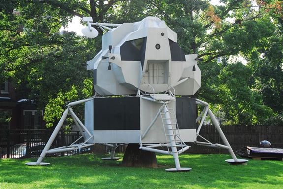
Here is a photograph of the Earth at approximately the same resolution.
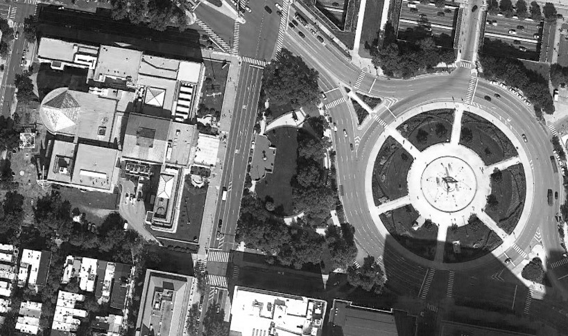
Unquestionably it shows "exceptional clarity and detail". If you blow up the image to see one of those rectangular things on the street, it will be quite pixellated. However, you know that those are cars, so you can, at a glance say, "Those are cars."
The Apollo equipment may look similarly grainy to you, but if you know what to look for, you can say, "That's a LM".
In the above photo, you can similarly identify cars, buses, pedestrians... and a full-size Apollo Lunar Module test article. Can you find it?
a reply to: masterp
At most of the Apollo sites, we can see the shadow of the USA flags that are still standing there. I'd call that exceptional clarity.
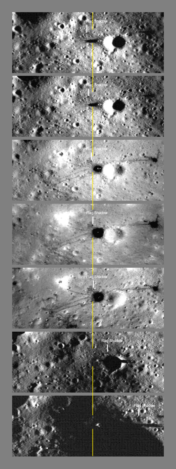
And while what you're looking at is indeed just some pixels across, I don't undestand how can someone look at this and not see that someone's been there, left stuff there, and trod all over the pristine lunar dust.
At most of the Apollo sites, we can see the shadow of the USA flags that are still standing there. I'd call that exceptional clarity.
And while what you're looking at is indeed just some pixels across, I don't undestand how can someone look at this and not see that someone's been there, left stuff there, and trod all over the pristine lunar dust.
originally posted by: wildespace
a reply to: masterp
I don't undestand how can someone look at this and not see that someone's been there, left stuff there, and trod all over the pristine lunar dust.
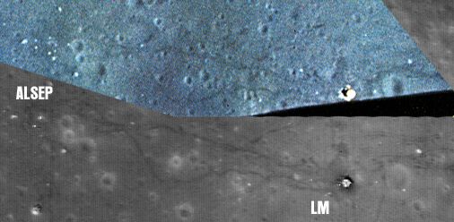
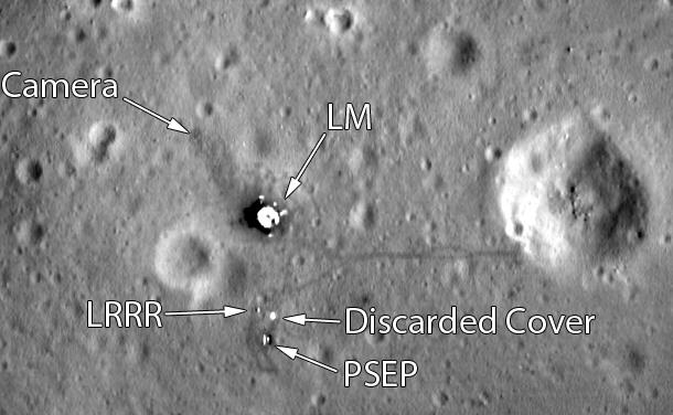
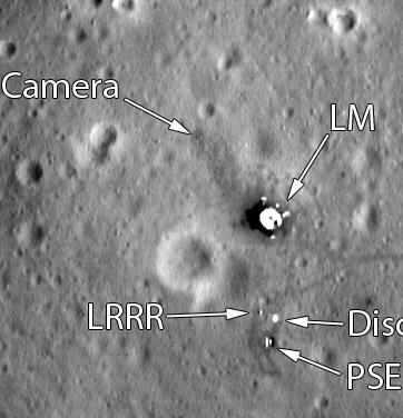
There's a good size correlation between the picture in your link and the image I posted above. The LM looks almost exactly the same size in both images. Also, you can see that the rover in your picture (on the right) is a bit smaller than the cars we see in the street view. The astronaut footpaths are, as expected, slightly wider than the pedestrians we see, since the disturbed lunar regolith as the astronauts lope along flies further in 1/6th G.
You can correlate the footpaths & rover tracks between the LM and the ALSEP experiments (on the upper left in your picture) with AS15-88-11947.
edit on 11-4-2016 by Saint Exupery because: Space - It's not just for astronauts.
a reply to: Saint Exupery
Sure they can be correlated, still it is no proof. I can take the picture you posted and draw, by hand, the tracks on a 2d surface and be fairly accurate.
Sure they can be correlated, still it is no proof. I can take the picture you posted and draw, by hand, the tracks on a 2d surface and be fairly accurate.
a reply to: masterp
So which one are you suggesting isn't genuine, the LRO view or the Apollo one?
You can also see those trails in the ascent footage taken by Apollo 15's LM as it returned to orbit, footage that also contains many features that can be confirmed not just by the LRO photographs but alo by Indian, Japanese and Chinese probes.
any graphic artist can make those images in photoshop. YOu can't believe any of them. They're just pictures. Who knows where they came from, what they
are, who made them in photoshop, etc etc.
originally posted by: masterp
a reply to: Saint Exupery
Sure they can be correlated, still it is no proof. I can take the picture you posted and draw, by hand, the tracks on a 2d surface and be fairly accurate.
Here is an image first posted by jra a member on here we both had the same idea he posted it first.
Top part still from DAC video taken as Apollo 17 left the Moon the bottom the LRO image.
People have matched small rocks & craters from Apollo images taken on the surface with the same rocks & craters on the LRO images not one or 2 but hundreds. Those items are so small you could only see them when on the surface or from the LRO images.
originally posted by: lavatrance
any graphic artist can make those images in photoshop. YOu can't believe any of them. They're just pictures. Who knows where they came from, what they are, who made them in photoshop, etc etc.
Then any GOOD graphic artist can spot fakes & manipulation.
originally posted by: lavatrance
any graphic artist can make those images in photoshop. YOu can't believe any of them. They're just pictures.
Impossible. There are probably hundreds of thousands of small craters, rocks, and other terrain features that can be correlated between Apollo and LRO images.
Who knows where they came from, what they are, who made them in photoshop, etc etc.
Apollo images posted on the Internet are typically scans of the 70mm Kodak film that was used in Hasselblad cameras. Direct, unedited scans can be found at the recently famous Flickr archive or at eol.jsc.nasa.gov...
LRO images come from Arizona State University. lroc.sese.asu.edu...
For example, here's an Apollo 15 photo taken using the panoramic camera onboard the Command Module: wms.lroc.asu.edu... It's incredibly high-rez, allowing you to zoom in on small craters and even boulders. You can then use LRO imagery of that area (for example, this one), and compare all the tiny craters, boulders, and folds of the terrain.
edit on 12-4-2016 by wildespace because: (no reason given)
The LM descent stages are 4 metres wide. The very best pixel resolution is 0.25m per pixel - how many pixels do you think a 4 metre wide object is going to have?
16 pixels (4 m / 0.25 m) is not 'clear images'. They are even less clear than a 8-bit video game of yesteryear.
On top of the descent stage you have the other experimental equipment and th trails to and from them, plus the other rocks and craters visible in Apollo TV, 16mm and video - all exactly where they should be.
They could be drawn exactly where they should be.
a reply to: masterp
'Could' is not the same as 'are', and given that any country or even private company can go look they would be stupid to even try.
Are the Japanese, Indians and Chinese also drawing in these details? Their probes also show them.
You can complain about the resolution all you like, it doesn't mean the features they are photographing aren't there.
Knee jerk denialism is not proof.
edit on 13/4/2016 by OneBigMonkeyToo because: (no reason given)
originally posted by: lavatrance
any graphic artist can make those images in photoshop. YOu can't believe any of them. They're just pictures. Who knows where they came from, what they are, who made them in photoshop, etc etc.
the same can be said of your ancestors.. they're just pictures afterall.. therefore it must mean that your ancestors were fake and you dont exist.. you are merely just a computer program typing out random words..
unless you can prove to me that you do exist?
How do you explain that this Apollo 11 LRO image
www.nasa.gov...
has much lower resolution than this drawing from 1978, where you can see things that are smaller than the footpads ?
www.hq.nasa.gov...
www.nasa.gov...
has much lower resolution than this drawing from 1978, where you can see things that are smaller than the footpads ?
www.hq.nasa.gov...
edit on 16-4-2016 by Ove38 because: text fix
a reply to: Ove38
Because the 1978 map is derived photogrammetrically from the Apollo 11 surface photographs and 16mm footage.
The only way that they can have those details is by having the photographs and video.
Because the 1978 map is derived photogrammetrically from the Apollo 11 surface photographs and 16mm footage.
The only way that they can have those details is by having the photographs and video.
edit on 17/4/2016 by OneBigMonkeyToo because:
clarity
In anticipation of other questions, here is the Apollo 11 LRO shot in comparison with the best Lunar Orbiter view of the same area:

These Moon Hoax people will never give up..even if they get there and touch it themselves, it will have been set up.
Move along please, this is a thread for those who want to see the moon and not get dragged into 'they could be fake'.
Move along please, this is a thread for those who want to see the moon and not get dragged into 'they could be fake'.
originally posted by: OneBigMonkeyToo
a reply to: Ove38
Because the 1978 map is derived photogrammetrically from the Apollo 11 surface photographs and 16mm footage.
The only way that they can have those details is by having the photographs and video.
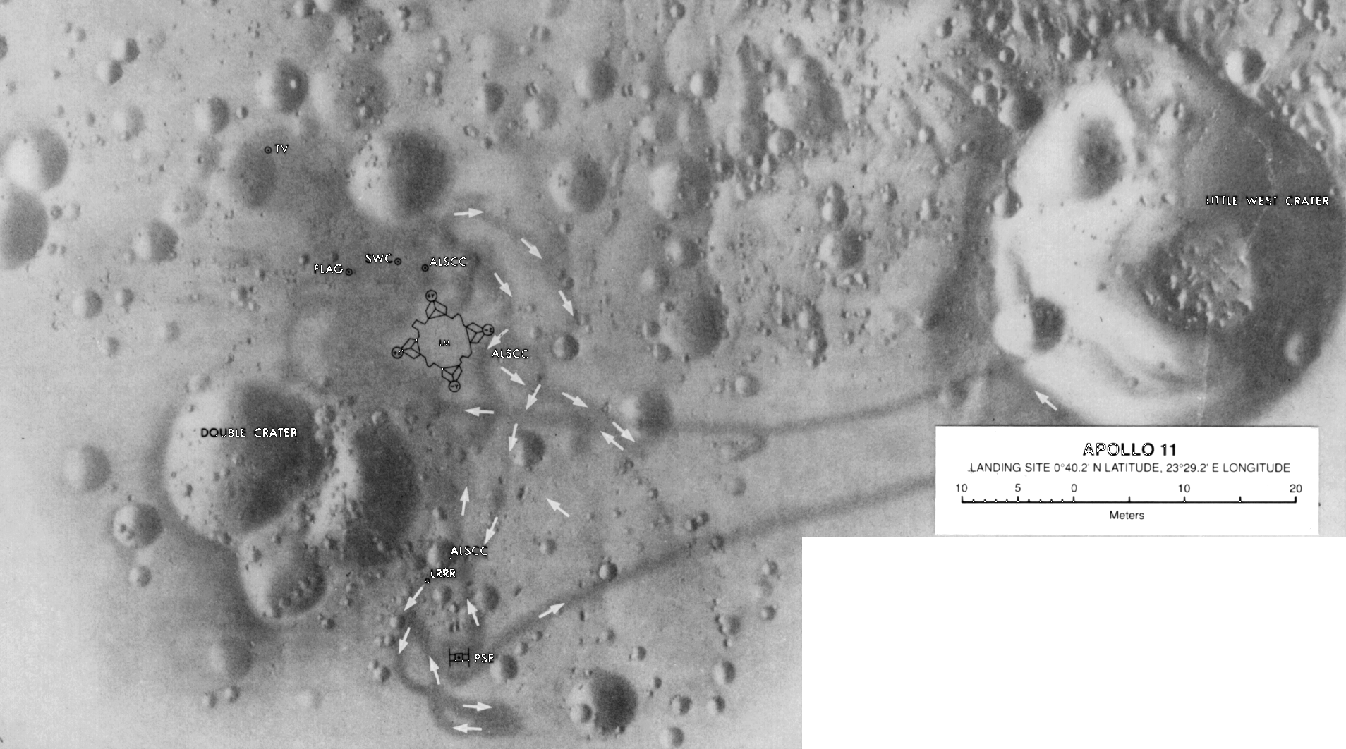
Ok, could you show me, a 1969 picture of the landing site, having all the details seen below ? Double crater is extremely detailed, show me a 1969 picture of the Double crater having the same details.
If not, how come they have better resolution 1978 then in 2013 ?
Made 1978
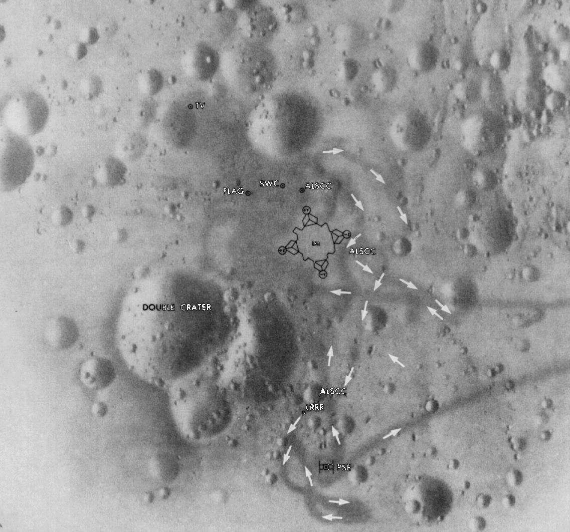
Made 2013
edit on 17-4-2016 by Ove38 because: text fix
originally posted by: Ove38
Ok, could you show me, a 1969 picture of the landing site, having all the details seen below ? Double crater is extremely detailed, show me a 1969 picture of the Double crater having the same details.
Ove, are you just completely incapable of doing any real research yourself? Apollo 11 only shot three rolls on the lunar surface: Magazines 37, 39 & 40. I found more than a dozen photos of the double crater at very high resolution. I found them on three different sites in less than a minute.
Look 'em up yourself or admit you're just trolling.
vvvvvvv See my sig line. vvvvvvv
edit on 17-4-2016 by Saint Exupery because: some people just gotta have their noses rubbed in it.
a reply to: Saint Exupery
Indeed - including the panoramas from the LM windows. Because we know how lazy moon hoaxers are and that he won't bother, and for the benefit of innocent bystanders, here's one:
www.hq.nasa.gov...
Doublet crater even featured in the TV broadcast from the surface.
These photographs (and 16mm footage) of the surface were published within days of their return, long before the LRO confirmed things.
new topics
-
whistleblower Captain Bill Uhouse on the Kingman UFO recovery
Aliens and UFOs: 2 hours ago -
1980s Arcade
General Chit Chat: 5 hours ago -
Deadpool and Wolverine
Movies: 5 hours ago -
Teenager makes chess history becoming the youngest challenger for the world championship crown
Other Current Events: 6 hours ago -
CIA botched its handling of sexual assault allegations, House intel report says
Breaking Alternative News: 7 hours ago -
Lawsuit Seeks to ‘Ban the Jab’ in Florida
Diseases and Pandemics: 10 hours ago
top topics
-
Lawsuit Seeks to ‘Ban the Jab’ in Florida
Diseases and Pandemics: 10 hours ago, 20 flags -
Starburst galaxy M82 - Webb Vs Hubble
Space Exploration: 12 hours ago, 11 flags -
CIA botched its handling of sexual assault allegations, House intel report says
Breaking Alternative News: 7 hours ago, 8 flags -
The Superstition of Full Moons Filling Hospitals Turns Out To Be True!
Medical Issues & Conspiracies: 14 hours ago, 8 flags -
IDF Intel Chief Resigns Over Hamas attack
Middle East Issues: 17 hours ago, 6 flags -
whistleblower Captain Bill Uhouse on the Kingman UFO recovery
Aliens and UFOs: 2 hours ago, 6 flags -
15 Unhealthiest Sodas On The Market
Health & Wellness: 12 hours ago, 5 flags -
Teenager makes chess history becoming the youngest challenger for the world championship crown
Other Current Events: 6 hours ago, 3 flags -
Deadpool and Wolverine
Movies: 5 hours ago, 3 flags -
1980s Arcade
General Chit Chat: 5 hours ago, 3 flags
active topics
-
New whistleblower Jason Sands speaks on Twitter Spaces last night.
Aliens and UFOs • 39 • : RookQueen2 -
23,000 Dead People Registered Within a Two Week Period In One State
US Political Madness • 39 • : Audreagassulke -
How ageing is" immune deficiency"
Medical Issues & Conspiracies • 25 • : Kenzo -
1980s Arcade
General Chit Chat • 7 • : Freeborn -
Europe declares war on Russia?
World War Three • 59 • : Freeborn -
George Knapp AMA on DI
Area 51 and other Facilities • 38 • : theshadowknows -
Candidate TRUMP Now Has Crazy Judge JUAN MERCHAN After Him - The Stormy Daniels Hush-Money Case.
Political Conspiracies • 618 • : WeMustCare -
-@TH3WH17ERABB17- -Q- ---TIME TO SHOW THE WORLD--- -Part- --44--
Dissecting Disinformation • 605 • : Ektar -
Teenager makes chess history becoming the youngest challenger for the world championship crown
Other Current Events • 3 • : Skinnerbot -
So you don't believe in the devil
Paranormal Studies • 143 • : burritocat