It looks like you're using an Ad Blocker.
Please white-list or disable AboveTopSecret.com in your ad-blocking tool.
Thank you.
Some features of ATS will be disabled while you continue to use an ad-blocker.

Advanced Watch Wednesday : Texas severe weather outbreak
page: 3share:
I was just making sure you are here to watch over us. Just saw a report of tennis ball size hair in Breckenridge.
Bad stuff has gone around me the last couple times...hoping...
Bad stuff has gone around me the last couple times...hoping...
a reply to: liveandlearn
I'm here and I will continue to update, we need to watch for breaks in the clouds which could add further instability to an already unstable atmosphere (as I watch the sun come out in wylie) this is concerning if we get up into the 80s as that dry line approaches storms could become particularly severe. I will continue to update.
I'm here and I will continue to update, we need to watch for breaks in the clouds which could add further instability to an already unstable atmosphere (as I watch the sun come out in wylie) this is concerning if we get up into the 80s as that dry line approaches storms could become particularly severe. I will continue to update.
Nothing much here in Dallas so far but Tyler, Tx area has a tornado warning.
a reply to: texasgirl
Indeed was just posting, also many storms are firing to our west and moving east towards us this has really just started to ramp up.
Indeed was just posting, also many storms are firing to our west and moving east towards us this has really just started to ramp up.
| Tornado Warning TORNADO WARNING TXC423-302045- /O.NEW.KSHV.TO.W.0018.160330T2006Z-160330T2045Z/ BULLETIN - EAS ACTIVATION REQUESTED TORNADO WARNING NATIONAL WEATHER SERVICE SHREVEPORT LA 306 PM CDT WED MAR 30 2016 THE NATIONAL WEATHER SERVICE IN SHREVEPORT HAS ISSUED A * TORNADO WARNING FOR... CENTRAL SMITH COUNTY IN NORTHEASTERN TEXAS... * UNTIL 345 PM CDT * AT 305 PM CDT...A SEVERE THUNDERSTORM CAPABLE OF PRODUCING A TORNADO WAS LOCATED NEAR EDOM...OR 16 MILES NORTHWEST OF TYLER...MOVING EAST AT 30 MPH. HAZARD...TORNADO. SOURCE...RADAR INDICATED ROTATION. IMPACT...FLYING DEBRIS WILL BE DANGEROUS TO THOSE CAUGHT WITHOUT SHELTER. MOBILE HOMES WILL BE DAMAGED OR DESTROYED. DAMAGE TO ROOFS...WINDOWS...AND VEHICLES WILL OCCUR. TREE DAMAGE IS LIKELY. * THIS DANGEROUS STORM WILL BE NEAR... LINDALE AROUND 325 PM CDT. TYLER AROUND 345 PM CDT. OTHER LOCATIONS IMPACTED BY THIS TORNADIC THUNDERSTORM INCLUDE RED SPRINGS...CARROLL AND WINONA...AND POSSIBLY MOTORISTS ALONG INTERSTATE 20 !! PRECAUTIONARY/PREPAREDNESS ACTIONS... TAKE COVER NOW! MOVE TO A BASEMENT OR AN INTERIOR ROOM ON THE LOWEST FLOOR OF A STURDY BUILDING. AVOID WINDOWS. IF YOU ARE OUTDOORS...IN A MOBILE HOME...OR IN A VEHICLE...MOVE TO THE CLOSEST SUBSTANTIAL SHELTER AND PROTECT YOURSELF FROM FLYING DEBRIS. MOTORISTS SHOULD NOT TAKE SHELTER UNDER HIGHWAY OVERPASSES. IF YOU CANNOT SAFELY DRIVE AWAY FROM THE TORNADO...AS A LAST RESORT...EITHER PARK YOUR VEHICLE AND STAY PUT...OR ABANDON YOUR VEHICLE AND LIE DOWN IN A LOW LYING AREA AND PROTECT YOURSELF FROM FLYING DEBRIS. TO REPORT SEVERE WEATHER CONTACT YOUR NEAREST LAW ENFORCEMENT AGENCY. THEY WILL SEND YOUR REPORT TO THE NATIONAL WEATHER SERVICE OFFICE IN SHREVEPORT. && LAT...LON 3258 9525 3256 9524 3257 9521 3254 9519 3255 9518 3255 9516 3257 9515 3254 9512 3256 9509 3254 9508 3254 9503 3255 9502 3235 9499 3230 9545 3237 9545 3237 9547 3242 9551 3248 9559 3257 9560 TIME...MOT...LOC 2005Z 262DEG 27KT 3243 9556 TORNADO...RADAR INDICATED HAIL...
a reply to: TechniXcality
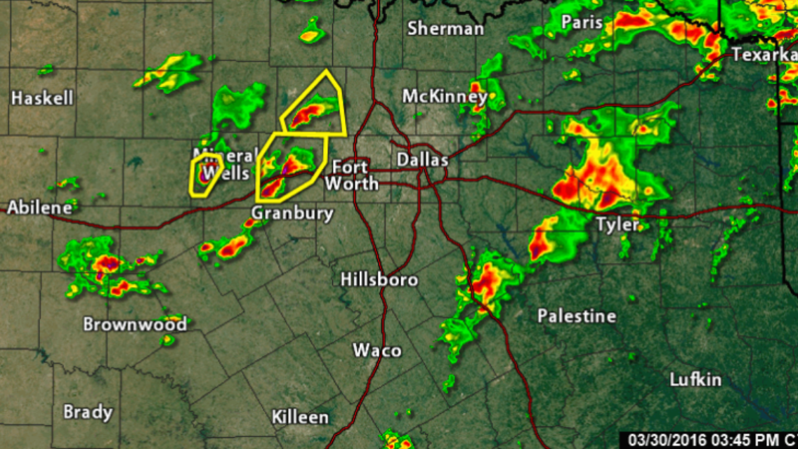
Also the storm in the yellow hatched square (Decatur) (severe thunderstorm warning) may be rotating it's showing the C signature in the southwest quadrant of the storm, wouldn't be surprised if this storm is tornado warned shortly.
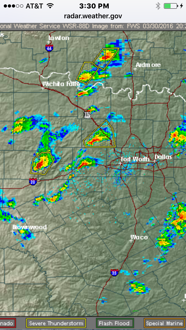
As you can see many storms are firing just west of the Dallas ft worth area moving our direction.
Also the storm in the yellow hatched square (Decatur) (severe thunderstorm warning) may be rotating it's showing the C signature in the southwest quadrant of the storm, wouldn't be surprised if this storm is tornado warned shortly.
As you can see many storms are firing just west of the Dallas ft worth area moving our direction.
edit on 30-3-2016 by TechniXcality because:
(no reason given)
a reply to: TechniXcality
Will keep everyone updated on what things are like just southeast of Ft Worth as this thing moves on.
Luckily my office let us work from home the rest of the day so I am able to ensure my dogs are safe inside.
Will keep everyone updated on what things are like just southeast of Ft Worth as this thing moves on.
Luckily my office let us work from home the rest of the day so I am able to ensure my dogs are safe inside.
a reply to: TechniXcality
Oh, my...I do see those storms just west of Ft. Worth forming into one long, nasty line.
Oh, my...I do see those storms just west of Ft. Worth forming into one long, nasty line.
TechX
Do you have a preferred station to watch weather? The did just report a wall cloud in Wise.
(for some reason this replied to Texasgirl and she was no where near)
Do you have a preferred station to watch weather? The did just report a wall cloud in Wise.
(for some reason this replied to Texasgirl and she was no where near)
edit on 30-3-2016 by liveandlearn because: (no reason given)
a reply to: liveandlearn
Wfaa, & Steve McCauley through his Facebook has very good updates, but typically I am glued to model analysis and radar, also I discuss among fellow storm chasers/weather watchers. But yes wfaa channel 8 is about as good as you will get via T.V meteriologists.
NWS forecast discussion for those interested
AREA FORECAST DISCUSSION NATIONAL WEATHER SERVICE FORT WORTH TX 243 PM CDT WED MAR 30 2016 .DISCUSSION... EARLY AFTERNOON SATELLITE IMAGERY CONTINUES TO SHOW SOME BREAKS IN THE CLOUD COVER MAINLY WEST OF INTERSTATE 35. TEMPERATURES HAVE WARMED INTO THE UPPER 70S AND LOWER 80S WITH THE DRYLINE MIXING EAST TOWARD WICHITA FALLS AND EXTENDING SOUTHWEST TOWARD SWEETWATER. LARGE SCALE FORCING FOR ASCENT CONTINUES TO SPREAD OVER THE AREA AND SHOULD HAVE NO PROBLEM LIFTING SURFACE BASED PARCELS ACROSS NORTH TEXAS THROUGH THIS EVENING. THE 18Z FWD SOUNDING DID INDICATE THE PRESENCE OF TWO WEAK CAPS...LIKELY THE RESULT OF SOME SUBSIDENCE IN THE WAKE OF EARLIER CONVECTION. OBJECTIVE ANALYSIS OF SEVERE PARAMETERS INDICATES THAT MOST OF NORTH TEXAS IS QUITE UNSTABLE WITH 1500-2000 J/KG CAPE WITH POCKETS OF HIGHER INSTABILITY IN AREAS WHERE THE SUN HAS PEAKED OUT. WIDESPREAD INHIBITION CONTINUES TO WEAKEN WHICH WILL SUPPORT MORE CONVECTIVE DEVELOPMENT OVER THE NEXT SEVERAL HOURS. THE DRYLINE WILL CONTINUE TO MOVE EAST THIS EVENING AND SCATTERED SEVERE THUNDERSTORMS WILL EVENTUALLY MOVE ACROSS NORTH TEXAS WITH THE BEST CHANCES ACROSS THE NORTHERN HALF OF THE CWA. STEEP LAPSE RATES WILL SUPPORT A VERY LARGE HAIL THREAT AND DAMAGING WIND THREAT. THE TORNADO THREAT WILL LIKELY BE LIMITED INITIALLY OWING TO GENERALLY WEAK DEEP LAYER SHEAR AND A BACKED MID LEVEL WIND PROFILE. THE WIND PROFILE IS EXPECTED TO BECOME A LITTLE MORE FAVORABLE LATER THIS EVENING AS THE STORMS CONTINUE EAST SO THIS POTENTIAL WILL CONTINUE TO BE MONITORED. CONCERNING THE FORECAST...WILL HAVE THE HIGHEST POPS SPREADING EAST INTO THE METROPLEX ALONG THE I-35 CORRIDOR AND NORTH TO THE RED RIVER THROUGH EARLY EVENING WITH A PROGRESSION RATHER QUICKLY INTO THE ARKLATEX BY MIDNIGHT. OVERNIGHT...AS THE MAIN TROUGH REMAINS TO THE WEST...WE WILL STILL BE IN A FAVORABLE AREA FOR ASCENT. MOST OF THE MODEL GUIDANCE BRING A SLUG OF MID LEVEL MOISTURE ACROSS NORTH TEXAS AFTER MIDNIGHT. IF THIS PANS OUT WITH STEEP LAPSE RATES STILL IN PLACE...ISOLATED ELEVATED CONVECTION MAY DEVELOP. HAIL WOULD BE THE MAIN THREAT WITH ANY STORMS LATE OVERNIGHT.
Down south central way it has just been light drizzle. Thankful.
Those of you in FT worth the storm is intensifying watch out
Severe Thunderstorm Warning SEVERE THUNDERSTORM WARNING TXC367-439-302230- /O.NEW.KFWD.SV.W.0088.160330T2143Z-160330T2230Z/ BULLETIN - IMMEDIATE BROADCAST REQUESTED SEVERE THUNDERSTORM WARNING NATIONAL WEATHER SERVICE FORT WORTH TX 443 PM CDT WED MAR 30 2016 THE NATIONAL WEATHER SERVICE IN FORT WORTH HAS ISSUED A * SEVERE THUNDERSTORM WARNING FOR... SOUTHEASTERN PARKER COUNTY IN NORTH CENTRAL TEXAS... TARRANT COUNTY IN NORTH CENTRAL TEXAS... * UNTIL 530 PM CDT * AT 443 PM CDT...SEVERE THUNDERSTORMS WERE LOCATED ALONG A LINE EXTENDING FROM RIVER OAKS TO 9 MILES NORTHWEST OF GODLEY...MOVING EAST AT 45 MPH. HAZARD...60 MPH WIND GUSTS AND NICKEL SIZE HAIL. SOURCE...RADAR INDICATED. IMPACT...EXPECT DAMAGE TO ROOFS...SIDING...AND TREES. * LOCATIONS IMPACTED INCLUDE... FORT WORTH...ARLINGTON...MANSFIELD...HALTOM CITY...HURST...BURLESON... WEATHERFORD...WATAUGA...BENBROOK...SAGINAW...WHITE SETTLEMENT...CROWLEY... FOREST HILL...AZLE...RICHLAND HILLS...RIVER OAKS...KENNEDALE...EVERMAN... SANSOM PARK AND LAKE WORTH. PRECAUTIONARY/PREPAREDNESS ACTIONS... FOR YOUR PROTECTION MOVE TO AN INTERIOR ROOM ON THE LOWEST FLOOR OF A BUILDING. && LAT...LON 3284 9721 3255 9709 3256 9782 3297 9756 TIME...MOT...LOC 2143Z 259DEG 38KT 3278 9741 3254 9764 HAIL...0.88IN WIND...60MPH $$ 92
a reply to: TechniXcality
My wife is driving up 287 and said looking west and north is a lot of lightning and "the big scary greenish clouds" lol.
She should be home soon then we will button down and hope the hail doesn't get too bad. Looks like a whole line is headed our way for the next couple hours...
Ironically I just got off the phone with our Nationwide insurance adjuster was going to check our roof today LOL from the hail damage from a couple weeks ago...
Also hearing rumbles of thunder.
News just mentioned mid to upper level rotation nw of FW...near saginaw if memory serves.
Thanks for the tip on 8...channel surfing less now.
Thanks for the tip on 8...channel surfing less now.
a reply to: liveandlearn
Tornado warning near Godley...radar only.
sirens going off now.
Tornado warning near Godley...radar only.
sirens going off now.
edit on 30-3-2016 by liveandlearn because: (no reason given)
a reply to: liveandlearn
Stay safe!! You are most certainly welcome check back in!
Stay safe!! You are most certainly welcome check back in!
| Tornado Warning TORNADO WARNING TXC251-302230- /O.NEW.KFWD.TO.W.0009.160330T2215Z-160330T2230Z/ BULLETIN - EAS ACTIVATION REQUESTED TORNADO WARNING NATIONAL WEATHER SERVICE FORT WORTH TX 515 PM CDT WED MAR 30 2016 THE NATIONAL WEATHER SERVICE IN FORT WORTH HAS ISSUED A * TORNADO WARNING FOR... NORTHWESTERN JOHNSON COUNTY IN NORTH CENTRAL TEXAS... * UNTIL 530 PM CDT * AT 514 PM CDT...SEVERE THUNDERSTORMS CAPABLE OF PRODUCING BOTH TORNADOES AND EXTENSIVE STRAIGHT LINE WIND DAMAGE WERE LOCATED OVER GODLEY...OR 11 MILES WEST OF JOSHUA...MOVING EAST AT 30 MPH. HAZARD...TORNADO AND QUARTER SIZE HAIL. SOURCE...RADAR INDICATED ROTATION. IMPACT...FLYING DEBRIS WILL BE DANGEROUS TO THOSE CAUGHT WITHOUT SHELTER. MOBILE HOMES WILL BE DAMAGED OR DESTROYED. DAMAGE TO ROOFS...WINDOWS...AND VEHICLES WILL OCCUR. TREE DAMAGE IS LIKELY. * THESE DANGEROUS STORMS WILL BE NEAR... GODLEY AROUND 520 PM CDT. CLEBURNE...KEENE...JOSHUA AND CROSS TIMBER AROUND 530 PM CDT. PRECAUTIONARY/PREPAREDNESS ACTIONS... TAKE COVER NOW! MOVE TO A BASEMENT OR AN INTERIOR ROOM ON THE LOWEST FLOOR OF A STURDY BUILDING. AVOID WINDOWS. IF YOU ARE OUTDOORS...IN A MOBILE HOME...OR IN A VEHICLE...MOVE TO THE CLOSEST SUBSTANTIAL SHELTER AND PROTECT YOURSELF FROM FLYING DEBRIS. && LAT...LON 3238 9761 3251 9761 3255 9739 3246 9730 3235 9736 TIME...MOT...LOC 2214Z 262DEG 25KT 3244 9757 TORNADO...RADAR INDICATED HAIL...1.00IN $$ 92
a reply to: TechniXcality
Keep us posted - my good bud is in Joshua and said he was out front of his place lookin west for a tornado and the sirens were going off...
I'm nervous cause he's in a pre-fab home... Any word on how strong this rotation might be?
Keep us posted - my good bud is in Joshua and said he was out front of his place lookin west for a tornado and the sirens were going off...
I'm nervous cause he's in a pre-fab home... Any word on how strong this rotation might be?
a reply to: SonOfThor
the rotation has died down a bit, but it could re-intensify at any moment. If hes got a good shot maybe he could take pictures of the wall cloud. It appears he should be seeing the brunt of it within the ten mins the storm is no longer tornado warned but straight line wind damage is possible and of course rotation as well. He should take cover ASAP to be on the safe side
the rotation has died down a bit, but it could re-intensify at any moment. If hes got a good shot maybe he could take pictures of the wall cloud. It appears he should be seeing the brunt of it within the ten mins the storm is no longer tornado warned but straight line wind damage is possible and of course rotation as well. He should take cover ASAP to be on the safe side
new topics
-
USO 10 miles west of caladesi island, Clearwater beach Florida
Aliens and UFOs: 3 hours ago
top topics
-
Anti-Israel Protesters in CHICAGO Chant 'Death to Israel and 'Death to America'
Social Issues and Civil Unrest: 15 hours ago, 15 flags -
Denver to Defund the Police 8.4 Million To Pay for Illegal Aliens
Social Issues and Civil Unrest: 17 hours ago, 14 flags -
Running Through Idiot Protestors Who Block The Road
Rant: 14 hours ago, 12 flags -
Fossils in Greece Suggest Human Ancestors Evolved in Europe, Not Africa
Origins and Creationism: 17 hours ago, 9 flags -
Report March 2024 - Underwater UFOs display capability that ‘jeopardizes US maritime security,’
Aliens and UFOs: 17 hours ago, 6 flags -
Tesla cutting 14,000 jobs
Global Meltdown: 12 hours ago, 6 flags -
USO 10 miles west of caladesi island, Clearwater beach Florida
Aliens and UFOs: 3 hours ago, 6 flags -
Israel ufo shoot down drones?
Aliens and UFOs: 12 hours ago, 5 flags -
Abortions in first 12 weeks should be legalised in Germany, commission says
Medical Issues & Conspiracies: 12 hours ago, 5 flags -
On this Day in History, April 15, 1865, Abraham Lincoln Passed Away.
General Chit Chat: 12 hours ago, 4 flags
active topics
-
Mandela Effect - It Happened to Me!
The Gray Area • 98 • : BeTheGoddess2 -
The Truth About Jesus
Conspiracies in Religions • 265 • : glend -
J Balvin Columbian Singer captured this Triangle UFO footage…….
Aliens and UFOs • 13 • : magicai -
Another whistleblower: Rear Admiral Tim Gallaudet
Aliens and UFOs • 27 • : Ophiuchus1 -
Terrifying Encounters With The Black Eyed Kids
Paranormal Studies • 36 • : Consvoli -
Abortions in first 12 weeks should be legalised in Germany, commission says
Medical Issues & Conspiracies • 9 • : Vermilion -
Running Through Idiot Protestors Who Block The Road
Rant • 45 • : glen200376 -
The Reality of the Laser
Military Projects • 27 • : Zaphod58 -
Israel ufo shoot down drones?
Aliens and UFOs • 17 • : Zaphod58 -
Tesla cutting 14,000 jobs
Global Meltdown • 43 • : Vermilion