It looks like you're using an Ad Blocker.
Please white-list or disable AboveTopSecret.com in your ad-blocking tool.
Thank you.
Some features of ATS will be disabled while you continue to use an ad-blocker.

Nice Nevada Desert shots from a drone
page: 2share:
originally posted by: FosterVS
originally posted by: Macenroe82
a reply to: FosterVS
What kind of drones do you have?
Not what you have. Wow, jealous.
www.youtube.com...
A bit OT, but the DJI video is impressive.
A few applications come to mind for drone use around the range. It would be fun to fly a grid over the F-4 crash site near Rachel and document all the debris. I would fly it over Texas Lake just to get a different perspective of the dry lake. You might be able to detect where aircraft have landed on it. You could photograph the craters near highway 6.
originally posted by: gariac
originally posted by: FosterVS
originally posted by: Macenroe82
a reply to: FosterVS
What kind of drones do you have?
Not what you have. Wow, jealous.
www.youtube.com...
A bit OT, but the DJI video is impressive.
A few applications come to mind for drone use around the range. It would be fun to fly a grid over the F-4 crash site near Rachel and document all the debris. I would fly it over Texas Lake just to get a different perspective of the dry lake. You might be able to detect where aircraft have landed on it. You could photograph the craters near highway 6.
I like your thinking. I might just try that at the F-4 crash site, and maybe the Weed crash site? Even a certain titanium craft, if I find the spot.
edit on 20-2-2016 by FosterVS because: (no reason given)
originally posted by: FosterVS
originally posted by: gariac
originally posted by: FosterVS
originally posted by: Macenroe82
a reply to: FosterVS
What kind of drones do you have?
Not what you have. Wow, jealous.
www.youtube.com...
A bit OT, but the DJI video is impressive.
A few applications come to mind for drone use around the range. It would be fun to fly a grid over the F-4 crash site near Rachel and document all the debris. I would fly it over Texas Lake just to get a different perspective of the dry lake. You might be able to detect where aircraft have landed on it. You could photograph the craters near highway 6.
I like your thinking. I might just try that at the F-4 crash site, and maybe the Weed crash site? Even a certain titanium craft, if I find the spot.
The funny thing about the Walt Ray crash is after countless people had found it, years later some guy finds huge pieces. You would have a hard time finding the bits and pieces I photographed.
As you know, these debris fields are huge. You need to search that Rachel site over a few small valleys. You might need to develop some technique where you use the sun to your advantage to see the glimmer of metal shards.
Now I wonder if it would be possible to detect metal from a drone. I'm thinking more of meteorites than crashes. Dry Lakes are a great place to find them.
originally posted by: FosterVS
originally posted by: gariac
a reply to: FosterVS
I'm calling that new Range 61 gate. ;-)
I thought THIS one was "new Range 61 Gate"?
37°17'19.68"N, 115°37'47.63"W
The one with the camera, located just over the border, to the right of the gate.
And this is "Wilson Gate"?
37°17'19.37"N, 115°26'34.59"W
I know for sure this one is the one with the camera up the hill to the left of the gate:
37°17'19.49"N, 115°35'27.89"W
I've got Bald Mountain gates 1-6 marked on my Google Earth, been to them all.
I think you and I should come up with official nomenclature for these border crossings.
Wilson Gate is fine.
How about Range 61 Camera gate for:
37°17'19.49"N, 115°35'27.89"W
Ditto on the camera. You can see it on Google Earth.
37°17'19.68"N, 115°37'47.63"W
I don't believe I have been to this gate. Looking at Google Earth, there seem to be two gates nearby. Maybe three depending on what you call a road.
I don't have a quad, so if the road looks dicey, I don't take it. Or I part and walk. You never know where a rancher might put a valve.
originally posted by: gariac
Wilson Gate is fine.
How about Range 61 Camera gate for:
37°17'19.49"N, 115°35'27.89"W
Ditto on the camera. You can see it on Google Earth.
37°17'19.68"N, 115°37'47.63"W
I don't believe I have been to this gate. Looking at Google Earth, there seem to be two gates nearby. Maybe three depending on what you call a road.
I don't have a quad, so if the road looks dicey, I don't take it. Or I part and walk. You never know where a rancher might put a valve.
"37°17'19.68"N, 115°37'47.63"W
I don't believe I have been to this gate. Looking at Google Earth, there seem to be two gates nearby. Maybe three depending on what you call a road."
I believe I was at that gate in 2014. There is a camera just on the other side of the fence, just out of reach, maybe 40 feet to the right?
originally posted by: FosterVS
originally posted by: gariac
Wilson Gate is fine.
How about Range 61 Camera gate for:
37°17'19.49"N, 115°35'27.89"W
Ditto on the camera. You can see it on Google Earth.
37°17'19.68"N, 115°37'47.63"W
I don't believe I have been to this gate. Looking at Google Earth, there seem to be two gates nearby. Maybe three depending on what you call a road.
I don't have a quad, so if the road looks dicey, I don't take it. Or I part and walk. You never know where a rancher might put a valve.
"37°17'19.68"N, 115°37'47.63"W
I don't believe I have been to this gate. Looking at Google Earth, there seem to be two gates nearby. Maybe three depending on what you call a road."
I believe I was at that gate in 2014. There is a camera just on the other side of the fence, just out of reach, maybe 40 feet to the right?
I know I haven't seen that camera setup. But I recall you said you found a camera near Roadblock Canyon. Is it possible you have the sites mixed ip?
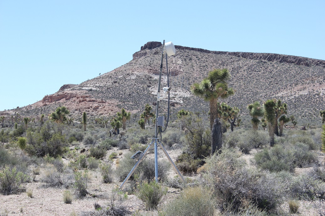
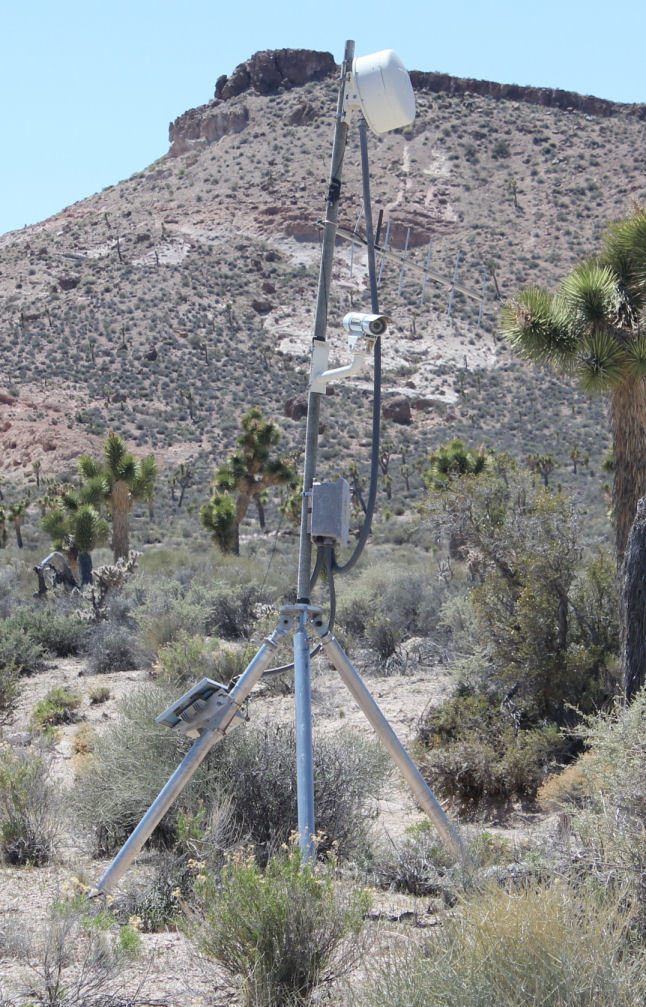
In any event, this photograph shows, perhaps verifies my hypothesis that the yagi antenna is for use by a person on the ground and the dish is for reaching Bald Mountain. (I used to call this a theory, but nitpickers gave me grief.)
The hypothesis:
1) Those solar cells are way too small for continuous video monitoring.
2) One possible surveillance scheme is the motion sensor way down the road goes off. It triggers the camera or the base sends a signal to the camera to turn on.
3) Assuming a base worker has approached the gate, they fire up a UHF commercial band radio. The yagi picks up the land mobile radio and relays the signal to the base over the microwave dish.
4) The dude at the base looks at the video and based on the communications deems the visitor to be kosher or sends the camo dudes.
5) An alternate version is the camera turns on when the land mobile radio is fired up.
The key here is the yagi pointing downward at the road.
6) I suppose a third alternative is the base vehicles have a sensor on them similar to the one that might be under the white bus. That would explain the use of a high gain yagi when a simple omni antenna would do for comms with a land mobile radio.
originally posted by: [post=20404324]gariacI know I haven't seen that camera setup. But I recall you said you found a camera near Roadblock Canyon. Is it possible you have the sites mixed ip?
In any event, this photograph shows, perhaps verifies my hypothesis that the yagi antenna is for use by a person on the ground and the dish is for reaching Bald Mountain. (I used to call this a theory, but nitpickers gave me grief.)
The hypothesis:
1) Those solar cells are way too small for continuous video monitoring.
2) One possible surveillance scheme is the motion sensor way down the road goes off. It triggers the camera or the base sends a signal to the camera to turn on.
3) Assuming a base worker has approached the gate, they fire up a UHF commercial band radio. The yagi picks up the land mobile radio and relays the signal to the base over the microwave dish.
4) The dude at the base looks at the video and based on the communications deems the visitor to be kosher or sends the camo dudes.
5) An alternate version is the camera turns on when the land mobile radio is fired up.
The key here is the yagi pointing downward at the road.
6) I suppose a third alternative is the base vehicles have a sensor on them similar to the one that might be under the white bus. That would explain the use of a high gain yagi when a simple omni antenna would do for comms with a land mobile radio.
I looked, 2014 and 2015, never saw a camera at or near Road Block canyon. Camo dudes never showed up either.
I am almost positive those coordinates I gave are correct. I should have taken a picture of the camera AND the fence line for directional reference.
I am fairly certain I was facing SW when I was taking that picture.As I recall, the camera isn't pointing right at the gate, but pointed down the trail leading to the gate.
The YAGI looks like it might be pointed towards either the shack or Bald Mountain.The dish appears almost pointed north! As you can see there is a ridge between here and Bald Mountain. Maybe there is a repeater or reflector north of Hwy 375 somewhere?
Next trip, I am gonna try and get a better perspective on where this stuff is pointed. I like your idea about a road sensor tripping the camera system.
edit on 23-2-2016 by FosterVS because: (no reason given)
The YouTube movies in question just returned to his YouTube channel.
originally posted by: SpeedFanatic
The YouTube movies in question just returned to his YouTube channel.
The long, 10 minutes video still isn't back.
I took a video snap of the returned Tikaboo clip and will work on digging up where it was actually shot. It is a long the road to Tikaboo but far from the parking area.
Many hills in that area have views of the base. You don't have to be on Tikaboo, but some parts of the base are not viewable unless you are on the peak. Possibly the lower Hills to the west have a better view into the newer hangars.
a reply to: gariac
That was harder than I thought, mostly because they used a road I don't use. I think they started here.
37°14'13.20"N 115°12'27.21"W
www inplanesight.org
Go to Nellis information. The "standard" route to Tikaboo is listed there. The road they used might be improved, but in the past it was so rough you might as well take the long route.
The drone takes off, then pans a bit to the left, showing the regular road to Tikaboo. Then it pans to the right, looking into the sun. That direction is opposite that of the base.
originally posted by: gariac
a reply to: gariac
That was harder than I thought, mostly because they used a road I don't use. I think they started here.
37°14'13.20"N 115°12'27.21"W
www inplanesight.org
Go to Nellis information. The "standard" route to Tikaboo is listed there. The road they used might be improved, but in the past it was so rough you might as well take the long route.
The drone takes off, then pans a bit to the left, showing the regular road to Tikaboo. Then it pans to the right, looking into the sun. That direction is opposite that of the base.
If that's where they flew from, I have no idea what the hell they were trying to accomplish. From my calculations, they would have had to fly to over 9000 ft. to see over the ranges in between that spot and Groom Lake. And it's 33 miles away. Me thinks they never did any homework, and thought Groom was just on the other side of the Pahranagat Mountain Range. And didn't realize there was another range in between. Jumbled Hills/Desert Range.
originally posted by: FosterVS
originally posted by: gariac
a reply to: gariac
That was harder than I thought, mostly because they used a road I don't use. I think they started here.
37°14'13.20"N 115°12'27.21"W
www inplanesight.org
Go to Nellis information. The "standard" route to Tikaboo is listed there. The road they used might be improved, but in the past it was so rough you might as well take the long route.
The drone takes off, then pans a bit to the left, showing the regular road to Tikaboo. Then it pans to the right, looking into the sun. That direction is opposite that of the base.
If that's where they flew from, I have no idea what the hell they were trying to accomplish. From my calculations, they would have had to fly to over 9000 ft. to see over the ranges in between that spot and Groom Lake. And it's 33 miles away. Me thinks they never did any homework, and thought Groom was just on the other side of the Pahranagat Mountain Range. And didn't realize there was another range in between. Jumbled Hills/Desert Range.
Well Tikaboo is 26 miles away, so your calculation is in the ballpark. I'm not sure they have to do 9000ft. They are starting at probably 6500ft. Tikaboo is a bit less than 8000ft. You can see the base from lower than 8000ft since we watch the base mostly from the camp site rather than the peak. For photography, you might as well climb the remaining few hundred feet from the camp to the peak, but otherwise the camp site is fine and you don't have a camera on your arse.
But your point is well taken. Why haul a drone out to Tikaboo if you can just launch it closer to the base.
I haven't mentioned this lately, but if you are going to photograph or shoot video through miles of atmosphere, you should color correct at the lens. I use a 400nm long pass filter in combination with a kr1.5. The 400nm long pass is way more useful for film than CCD, but I have it from the film days. The kr1.5 reduces a lot of the blue due to the haze, which in turn allows the CCD to set the exposure on the base rather than the atmosphere. This is the thing you can't fix in post because the "information" never made it to the sensor, or more correctly was lost in the noise.
I've never really found a good book on long distance photography. There are books on aerial photography, but generally nobody considers shooting from more than 3 miles away. Even satellites are effectively at the three miles limit if you consider that is the limit of breathable atmosphere. (Obvioisly the satellite itself is much higher, but most of the loss is in the first three miles.)
One idea is just to put on an amber or orange filter and convert to grayscale.
a reply to: gariac
Bummer there are few books on telephotography past 3 miles of atmosphere.
I believe this problem is dealt with by the EO/IR payload OEMs such as Goodrich ISR Systems (now UTC Aerospace Systems) out of Westford, MA.
One of their requirements is large slant ranges flying tens of miles off the coast of unfriendly countries, looking in (EO/IR/Multispectral) from tens of thousands of feet altitude.
They must have this problem figured out, otherwise I don't believe they'd bother flying those missions (other than ELINT/SIGINT collection more common today). That was one of the primary requirements for the RB-45Cs and the Canberras using K-30 cameras, and I don't believe they were out to collect RF signals - so to me that validates the capability of the optics at distance through atmosphere - even back in the 1950s.
You may have looked into that area for ideas, I suppose.
originally posted by: gariac
Well Tikaboo is 26 miles away, so your calculation is in the ballpark. I'm not sure they have to do 9000ft. They are starting at probably 6500ft. Tikaboo is a bit less than 8000ft. You can see the base from lower than 8000ft since we watch the base mostly from the camp site rather than the peak. For photography, you might as well climb the remaining few hundred feet from the camp to the peak, but otherwise the camp site is fine and you don't have a camera on your arse.
But your point is well taken. Why haul a drone out to Tikaboo if you can just launch it closer to the base.
I haven't mentioned this lately, but if you are going to photograph or shoot video through miles of atmosphere, you should color correct at the lens. I use a 400nm long pass filter in combination with a kr1.5. The 400nm long pass is way more useful for film than CCD, but I have it from the film days. The kr1.5 reduces a lot of the blue due to the haze, which in turn allows the CCD to set the exposure on the base rather than the atmosphere. This is the thing you can't fix in post because the "information" never made it to the sensor, or more correctly was lost in the noise.
I've never really found a good book on long distance photography. There are books on aerial photography, but generally nobody considers shooting from more than 3 miles away. Even satellites are effectively at the three miles limit if you consider that is the limit of breathable atmosphere. (Obvioisly the satellite itself is much higher, but most of the loss is in the first three miles.)
One idea is just to put on an amber or orange filter and convert to grayscale.
Going by GE, there's a 6100 ft. peak here (37.239047°, -115.578072°) 20 miles away. It's been a long time since trigonometry, I was just ball-parking it.
I've been trying to find info about filtering, etc. for long distance "landscape" shots. Most of what I have read is directed at "birders", or taking landscape shots and are not worried about fine details at 20+ miles. Never mind heat haze and dust.
I tried both a UV and polarizing filters, neither seemed to help.
a reply to: FosterVS
The deal with UV is film is very sensitive to it, hence they "Sky/UV" filters that everyone sells. The problem is few of those filters actually removes much UV. This is very easy to prove if you have a UV flashlight (rock hound gear) and anything that reacts to UV, generally a old phosphorus type display. If you own an old oscilloscope, that is perfect. Plop the Sky/UV filter on the scope screen, turn on the light, and the filter does nothing. I use a "scientific" grade filter from Andover
www.andovercorp.com...
www.schneideroptics.com...
Schneider Optics makes B+W filters and their UV blocking technology is similar to Andover. I use their kr1.5.
www.schneideroptics.com...
For CCD use, the B+W KR1.5 alone should be good enough since CCDs are not very sensitive to UV. They are very sensitive to IR, but your camera should have decent IR filtering. Well make that your DSLR. I have no idea about the cameras in drones.
Polarizers are only useful IMHO if you are trying to darken the sky. The sun needs to be behind you and you need to rotate the polarizer to get the optimal sky darkening. They can be useful in photographing aircraft in the sky if you don't mind the light loss.
Any image sensing device has a limited dynamic range. If your scene has a lot of bright blue sky in it, the exposure will be set not to "blow out" the blue pixels. If red levels in the scene are significantly less than blue, they will fall into the noise of the red pixels. By color correcting before the CCD, you can keep the green and red pixels from entering the noise by reducing the blue in the scene.
Assuming you have no sky in your scene, you still have haze from water vapor in the sky. You can do an internet search on "why is the sky blue" to get an explanation on the blue cast caused by water vapor. Suffice it to say just use the filters designed to reduce sky like the KR1.5 and you will improve the image. The color of the haze is inversely proportional to the 4th power of the wavelength, so a little filtering of blue through purple goes a long way.
I think the only drone technology that will be as good as shooting from Tikaboo with a telescope is an octocopter that can lift a DSLR with a 400mm lens and at least a 1.4 teleconverter. It would have to be at the 15 mile drone limit. Of course the USAF can extend the restricted airspace far easier than they can steal land. I'm really surprised they didn't do that as a solution to the drone issue.
edit on 28-2-2016 by gariac because: (no reason given)
edit on 28-2-2016 by gariac because: (no reason
given)
edit on 28-2-2016 by gariac because: (no reason given)
new topics
-
Massachusetts Drag Queen Leads Young Kids in Free Palestine Chant
Social Issues and Civil Unrest: 4 minutes ago -
Weinstein's conviction overturned
Mainstream News: 1 hours ago -
Supreme Court Oral Arguments 4.25.2024 - Are PRESIDENTS IMMUNE From Later Being Prosecuted.
Above Politics: 2 hours ago -
Krystalnacht on today's most elite Universities?
Social Issues and Civil Unrest: 3 hours ago -
Chris Christie Wishes Death Upon Trump and Ramaswamy
Politicians & People: 3 hours ago -
University of Texas Instantly Shuts Down Anti Israel Protests
Education and Media: 5 hours ago -
Any one suspicious of fever promotions events, major investor Goldman Sachs card only.
The Gray Area: 7 hours ago
top topics
-
VP's Secret Service agent brawls with other agents at Andrews
Mainstream News: 16 hours ago, 11 flags -
Krystalnacht on today's most elite Universities?
Social Issues and Civil Unrest: 3 hours ago, 7 flags -
Nearly 70% Of Americans Want Talks To End War In Ukraine
Political Issues: 17 hours ago, 6 flags -
Sunak spinning the sickness figures
Other Current Events: 17 hours ago, 5 flags -
Electrical tricks for saving money
Education and Media: 15 hours ago, 5 flags -
Weinstein's conviction overturned
Mainstream News: 1 hours ago, 5 flags -
Supreme Court Oral Arguments 4.25.2024 - Are PRESIDENTS IMMUNE From Later Being Prosecuted.
Above Politics: 2 hours ago, 5 flags -
University of Texas Instantly Shuts Down Anti Israel Protests
Education and Media: 5 hours ago, 3 flags -
Any one suspicious of fever promotions events, major investor Goldman Sachs card only.
The Gray Area: 7 hours ago, 2 flags -
Chris Christie Wishes Death Upon Trump and Ramaswamy
Politicians & People: 3 hours ago, 1 flags
active topics
-
VP's Secret Service agent brawls with other agents at Andrews
Mainstream News • 47 • : ByeByeAmericanPie -
"We're All Hamas" Heard at Columbia University Protests
Social Issues and Civil Unrest • 284 • : 5thHead -
University of Texas Instantly Shuts Down Anti Israel Protests
Education and Media • 110 • : DBCowboy -
Supreme Court Oral Arguments 4.25.2024 - Are PRESIDENTS IMMUNE From Later Being Prosecuted.
Above Politics • 41 • : xuenchen -
Chris Christie Wishes Death Upon Trump and Ramaswamy
Politicians & People • 14 • : underpass61 -
-@TH3WH17ERABB17- -Q- ---TIME TO SHOW THE WORLD--- -Part- --44--
Dissecting Disinformation • 672 • : Thoughtful3 -
Candidate TRUMP Now Has Crazy Judge JUAN MERCHAN After Him - The Stormy Daniels Hush-Money Case.
Political Conspiracies • 750 • : Justoneman -
Massachusetts Drag Queen Leads Young Kids in Free Palestine Chant
Social Issues and Civil Unrest • 0 • : FlyersFan -
British TV Presenter Refuses To Use Guest's Preferred Pronouns
Education and Media • 160 • : WakeUpBeer -
God's Righteousness is Greater than Our Wrath
Religion, Faith, And Theology • 26 • : CristianVictoria