It looks like you're using an Ad Blocker.
Please white-list or disable AboveTopSecret.com in your ad-blocking tool.
Thank you.
Some features of ATS will be disabled while you continue to use an ad-blocker.

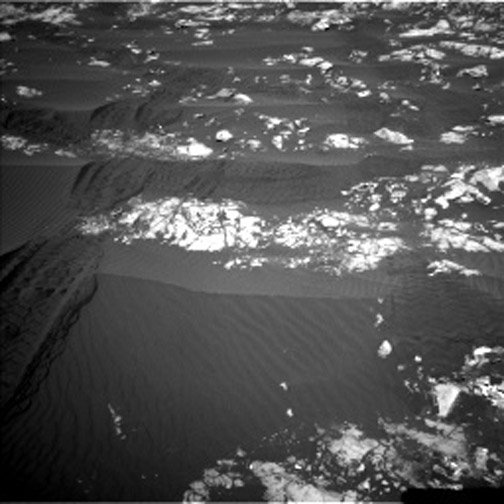
Curiosity Rover - Sol 1196 - Parallels and Cross-Rungs - MASTCAM
page: 12
share:
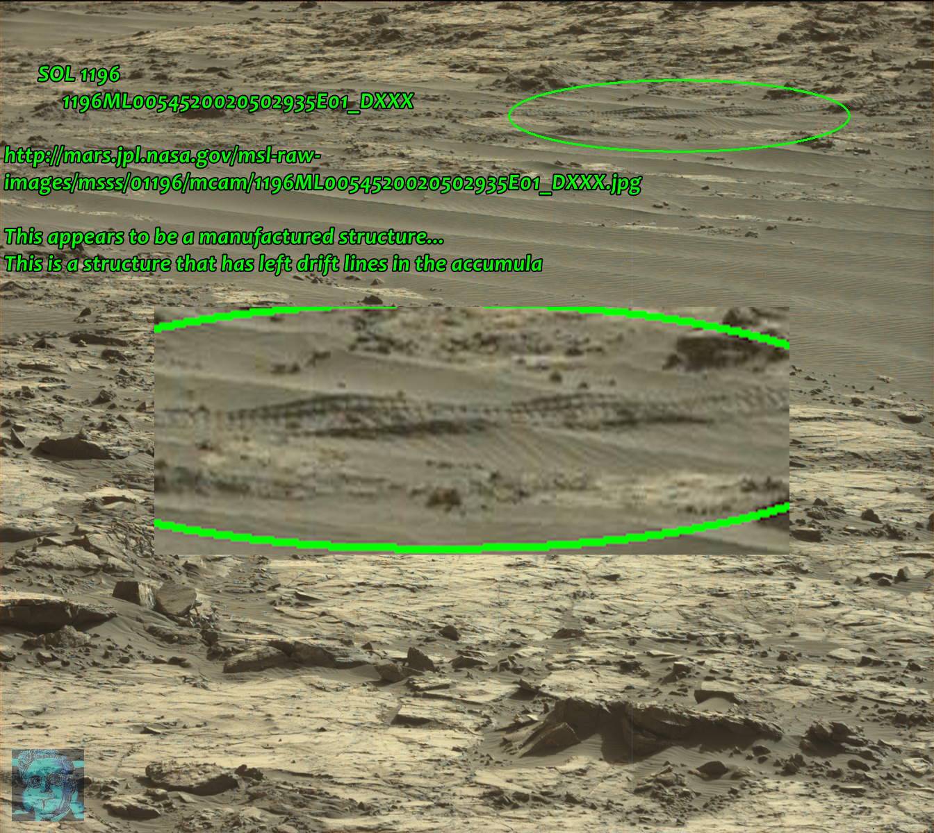
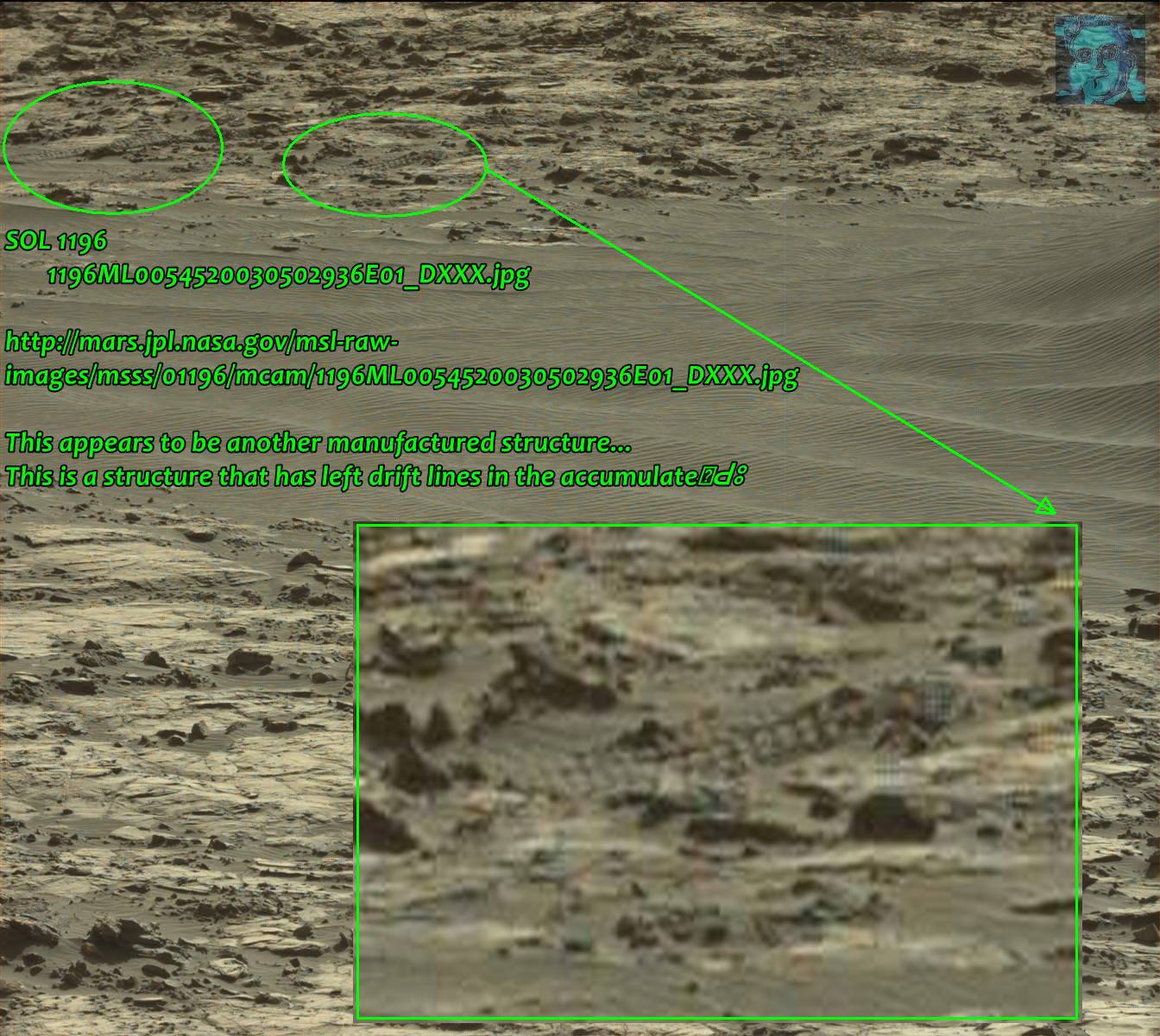
SOL 1196
1196ML0054520020502935E01_DXXX
mars.jpl.nasa.gov...
AND IN
mars.jpl.nasa.gov...
If one of the photog/Image experts could analyze this with better software than I have, it would be appreciated.
This appears to be a manufactured structure, some type of a "Ladder & Rung" assembly...
it reminds me of an overhead cable tray structure, in its form. (Annotated by the green oval....)
It has left drift lines over time in the accumulated micro-dunes downwind...
a reply to: BuzzDengue
They look like rover tracks to me, unless you're referring to something else.
They look like rover tracks to me, unless you're referring to something else.
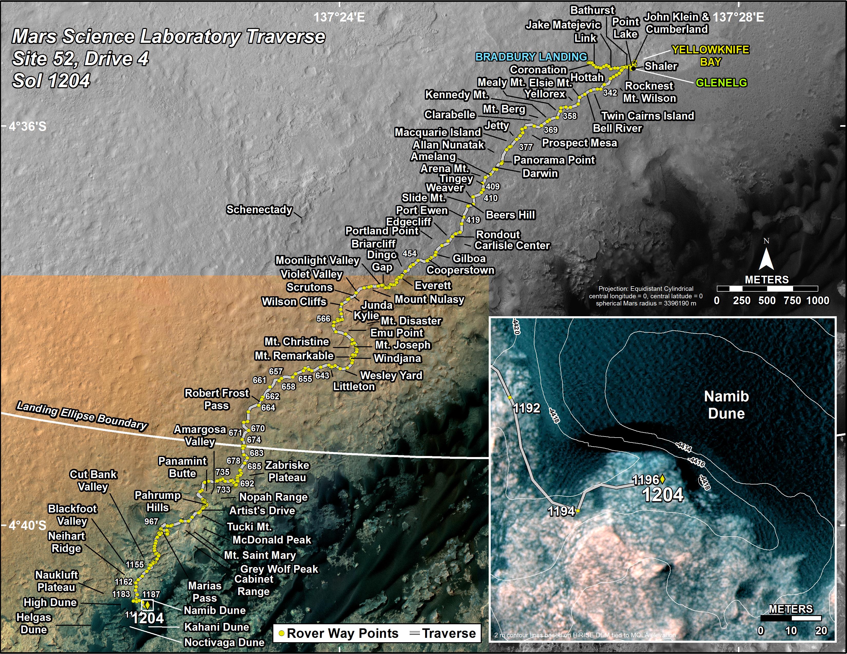
Curiosity's traverse map from Sol 1196 (the day the image was taken) shows that Curiosity's path curved around a bit, so that directly behind
Curiosity (maybe 40 meters away) would be the Rover's trail left between Sol 1192 and 1194.
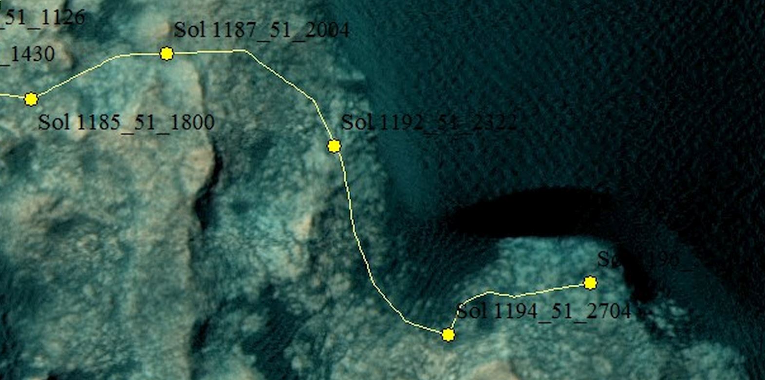
Link to Full-Sized Image
As you can see from the satellite image from above, between sol 1192 and 1194, the rover passed through some terrain where the sand from Namid Dune is spilling out over a more rocky area -- which is similar to the terrain in which we see that the "track-like lines" in question in the Rover image from Sol 1196 in the OP.
Therefore, maybe it's just the rover's wheel tracks.
edit on 1/14/2016 by Soylent Green Is People because: (no reason given)
In this picture, I see a few old car tyres buried in the mud. There's one which is less than half complete:
mars.jpl.nasa.gov...
mars.jpl.nasa.gov...
a reply to: Devino
If you use the original and a good zoom, they appear 3-D above the surface.
I thought MSL tracks at first also but the MSL doesn't leave intermittent tracks in the soil... notice either side are not showing the pattern in soft soil. Maybe take a second look?
If you use the original and a good zoom, they appear 3-D above the surface.
I thought MSL tracks at first also but the MSL doesn't leave intermittent tracks in the soil... notice either side are not showing the pattern in soft soil. Maybe take a second look?
a reply to: BuzzDengue
Sure does look like twisted metal to some noob like me ,But those pictures are taken on Mars so i must be wrong
Sure does look like twisted metal to some noob like me ,But those pictures are taken on Mars so i must be wrong
a reply to: Soylent Green Is People
At a range estimated at around 97 feet from the MSL, the object in question is not indicative of MSL tracks per the mission map.
If you employ zoom you can see it raised up above the surface. In addition, if it were tracks, they wouldn't be intermittent. Could you take a closer look?
At a range estimated at around 97 feet from the MSL, the object in question is not indicative of MSL tracks per the mission map.
If you employ zoom you can see it raised up above the surface. In addition, if it were tracks, they wouldn't be intermittent. Could you take a closer look?
originally posted by: BuzzDengue
a reply to: Soylent Green Is People
At a range estimated at around 97 feet from the MSL, the object in question is not indicative of MSL tracks per the mission map.
If you employ zoom you can see it raised up above the surface. In addition, if it were tracks, they wouldn't be intermittent. Could you take a closer look?
The tracks look to me like they are in the sand that is on the surface -- not elevated above the surface. And they might be intermittent depending on how sandy or rocky the area is that the rover is driving over.
Here are some images from the Navigation Cams (Navcams) taken on Sol 1215. On Sol 1215, the rover drove back over the same area that it drove over on sol 1192 (when it was driving over an area of mixed rocky and sandy terrain that I talked about in my other post above).

Link to Sol 1215 Left Navcam images
Link to Sol 1215 Right Navcam images
Traverse map Sol 1216:
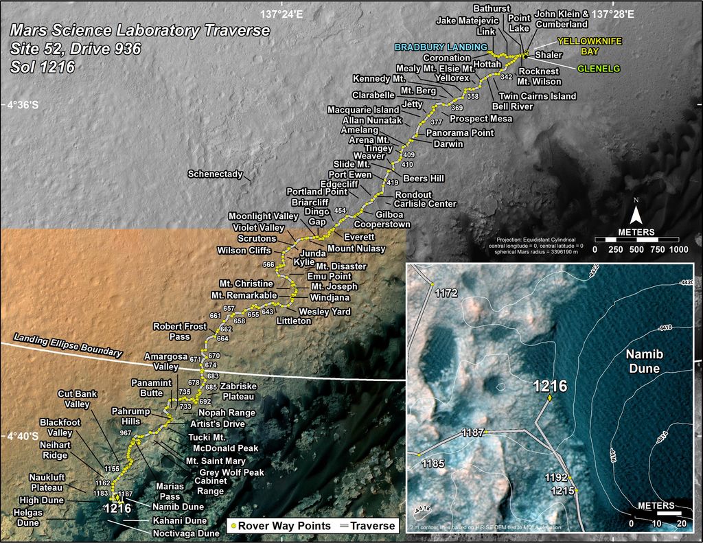
Link to Full-Size Traverse Map
It looks like the rover's tracks, in one of the photos we see that there are two marks side by side.
I have to look for more photos.
I have to look for more photos.
I took a look again yet I see the same thing. Be careful not to over zoom as you’ll start to get pixilation which creates false artifacts that could cause a track to look like a raised rail. I have been tricked many times in the past by over zooming Rover pictures that create all kinds of artificial looking objects.
originally posted by: BuzzDengue
a reply to: Devino
If you use the original and a good zoom, they appear 3-D above the surface.
I thought MSL tracks at first also but the MSL doesn't leave intermittent tracks in the soil... notice either side are not showing the pattern in soft soil. Maybe take a second look?
The intermittent tracks you see are probably due to different soil types, sand and more solid material like rock. I see tracks left in what looks like sand and not in areas that look more like solid ground. By the way, these features look like what I would expect rover tracks to look like. If research shows that the rover was there a few days ago then I think we have our answer.
edit on 1/14/2016 by Devino because: (no reason given)
new topics
-
HORRIBLE !! Russian Soldier Drinking Own Urine To Survive In Battle
World War Three: 1 hours ago -
Bobiverse
Fantasy & Science Fiction: 4 hours ago -
Florida man's trip overseas ends in shock over $143,000 T-Mobile phone bill
Social Issues and Civil Unrest: 4 hours ago -
Former Labour minister Frank Field dies aged 81
People: 6 hours ago -
SETI chief says US has no evidence for alien technology. 'And we never have'
Aliens and UFOs: 8 hours ago -
This is our Story
General Entertainment: 10 hours ago
top topics
-
President BIDEN Vows to Make Americans Pay More Federal Taxes in 2025 - Political Suicide.
2024 Elections: 13 hours ago, 16 flags -
One Flame Throwing Robot Dog for Christmas Please!
Weaponry: 17 hours ago, 6 flags -
Florida man's trip overseas ends in shock over $143,000 T-Mobile phone bill
Social Issues and Civil Unrest: 4 hours ago, 6 flags -
SETI chief says US has no evidence for alien technology. 'And we never have'
Aliens and UFOs: 8 hours ago, 6 flags -
Don't take advantage of people just because it seems easy it will backfire
Rant: 17 hours ago, 4 flags -
Ditching physical money
History: 17 hours ago, 4 flags -
Former Labour minister Frank Field dies aged 81
People: 6 hours ago, 4 flags -
Bobiverse
Fantasy & Science Fiction: 4 hours ago, 3 flags -
This is our Story
General Entertainment: 10 hours ago, 3 flags -
Ode to Artemis
General Chit Chat: 13 hours ago, 3 flags
active topics
-
American Government to Sanction Israel Defence Force in the West Bank
Middle East Issues • 54 • : yuppa -
-@TH3WH17ERABB17- -Q- ---TIME TO SHOW THE WORLD--- -Part- --44--
Dissecting Disinformation • 645 • : Thoughtful3 -
Florida man's trip overseas ends in shock over $143,000 T-Mobile phone bill
Social Issues and Civil Unrest • 5 • : Consvoli -
Breaking Baltimore, ship brings down bridge, mass casualties
Other Current Events • 478 • : IndieA -
Russia Ukraine Update Thread - part 3
World War Three • 5726 • : stu119 -
Thousands Of Young Ukrainian Men Trying To Flee The Country To Avoid Conscription And The War
Other Current Events • 129 • : yuppa -
One Flame Throwing Robot Dog for Christmas Please!
Weaponry • 10 • : ATruGod -
HORRIBLE !! Russian Soldier Drinking Own Urine To Survive In Battle
World War Three • 8 • : Astyanax -
New whistleblower Jason Sands speaks on Twitter Spaces last night.
Aliens and UFOs • 51 • : Ophiuchus1 -
The Reality of the Laser
Military Projects • 40 • : Zaphod58
2