It looks like you're using an Ad Blocker.
Please white-list or disable AboveTopSecret.com in your ad-blocking tool.
Thank you.
Some features of ATS will be disabled while you continue to use an ad-blocker.

Quake Watch 2016
page: 8share:
a reply to: Britguy
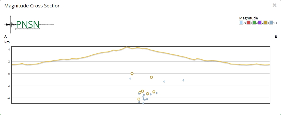
Some decent sized aftershocks;
UTC, Mag, Lat, Long, Depth, Where
25/01/2016 4:22, 6.3, 35.62°N, 3.72°W, 10, Strait of Gibraltar
25/01/2016 4:30, 4.8, 35.63°N, 3.90°W, 10, Strait of Gibraltar
25/01/2016 4:34, 4.9, 35.65°N, 3.80°W, 10, Strait of Gibraltar
25/01/2016 5:03, 4.3, 35.60°N, 3.84°W, 10, Strait of Gibraltar
25/01/2016 5:37, 4.4, 35.46°N, 3.78°W, 10, Strait of Gibraltar
25/01/2016 5:54, 5.1, 35.48°N, 3.84°W, 10, Strait of Gibraltar
25/01/2016 6:10, 4.9, 35.51°N, 3.89°W, 10, Strait of Gibraltar
25/01/2016 8:25, 4.3, 35.55°N, 3.82°W, 10, Strait of Gibraltar
25/01/2016 14:52, 4.6, 35.63°N, 3.69°W, 10, Strait of Gibraltar
geofon.gfz-potsdam.de...
Spanish Network IGN call the area ALBORÁN SUR
www.02.ign.es...
quite a few foreshocks it appears
Time (GMT)*, Lat, Long, Mag, Magnitude Type, Location
21/01/2016 13:47, 35.637, -3.7997, 5.1, Mw, ALBORÁN SUR
21/01/2016 13:57, 35.6529, -3.7838, 3.3, mbLg, ALBORÁN SUR
22/01/2016 3:14, 35.6347, -3.7835, 3.2, mbLg, ALBORÁN SUR
23/01/2016 13:18, 35.6211, -3.8058, 2.8, mbLg, ALBORÁN SUR
IGN show lower magnitudes, except for the main shock
25/01/2016 4:22, 35.6331, -3.8103, 6.3, Mw, ALBORÁN SUR
25/01/2016 4:34, 35.6178, -3.8118, 4.5, mbLg, ALBORÁN SUR
25/01/2016 5:54, 35.4762, -3.8392, 4.6, mbLg, ALBORÁN SUR
25/01/2016 14:52, 35.672, -3.7119, 4.4, mbLg, ALBORÁN SUR
a reply to: muzzy
You noticed the foreshock as well. I saw it pop up a few days ago and wondered about it. Spain has lots of eathquakes and the area has big faults, so earthquakes aren't rare, they're just not as active as other zones. Of course I continue on writing here, I think I'll bring up clustering again. The Eastern Mediterranean (OH MY GOD< I SPELLED IT RIGHT THE FIRST TIME_ MY 12 YEAR OLD SON WAS TEASING ME ABOUT MY TERRRRRIBLE SPELLING THIS WEEKEND_ WOOO I"M THE BEST)
As I was going to comment on, there were a few nice size quakes in and around Iran. China as well. It makes me think Asia Central, or Turkey. I still think Turkey is so overdue and when it happens it won't be a surprise. And given the geo-political mess there at the moment, if it were to happen, GOD HELP US.
Anyway, one other area I've been thinking about it Alaska. The 7M doesn't exactly interest me. Because I have recently heard two stories about zones in Alaska that are set to do some damage is the wake up. Off the top of my head, I can't remember which areas they were talking about, Alaska and the Island are an immense area. Maybe I'll look it up and post if I'm not lazy.
Popo Volcano is having a fuming fit...
Yellowstone is have the odd little one or three or seven, but nothing really exciting. The caldera is stalled and probably subsiding.
Also, I'm not going to suggest Alaska, and the other Idaho, and Northern Nevada are due to lunar influences, I'm not going to suggest it was the moon, I haven't checked the perigee/apogee calculator recently. But I did look out the window the other night and saw the big old thing on the horizon. I love it when I catch it on the rise and when it is at its biggest. Also, I think that big bad moon may have may the tides so large to helped the Jersey shore get its ass kicked- again.
The reason I'm suggesting the moon is, if the earthquakes in Idaho and Nevada are in the
a reply to: muzzy
Hey Muzzy, Do you know anything about Data Buoy's?
www.ndbc.noaa.gov...
I have been watching this buoy for the last 2 day's and it seems, the Height column seems to be rising.
We have had a few earthquakes in this area, so it has peaked my interest.
I would appreciate anyone who could help me out on this. I think, I may not be really understanding the numbers.
I just wanted to add... 2.5 meters = 8.20 feet ?
Hey Muzzy, Do you know anything about Data Buoy's?
www.ndbc.noaa.gov...
I have been watching this buoy for the last 2 day's and it seems, the Height column seems to be rising.
We have had a few earthquakes in this area, so it has peaked my interest.
I would appreciate anyone who could help me out on this. I think, I may not be really understanding the numbers.
edit on 25-1-2016 by
crappiekat because: (no reason given)
I just wanted to add... 2.5 meters = 8.20 feet ?
edit on 25-1-2016 by crappiekat because: to add
The last great earthquake on the Cascadia Subduction Zone was 316 years ago, today.
What will the next Mag 8+ earthquake bring?
WA state Dept of Natural Resources blog post
This video came out a few days ago, showing updated modeling of the Jan 26, 1700 tsunami.
FEMA is coordinating a 4-day functional exercise in June for emergency managers at levels (local, county, state, federal) to test and train for this coming emergency. Cascadia Rising
I'm really happy to see the governments take this threat seriously. Being prepared is the only option.
edit on 1/26/2016 by Olivine because:
fix link, i hope
a reply to: Olivine
Will you be participating in the 4 day exercise?
I don't want to sound morbid, but I think going thru an exercise like that would be fun, but yet scary.
One of the articles say's 600 years, and the other say's 500 hundred. I realize they do not have a precise answer, but I think that kind of "non consistancy" get the nay sayers going.
They need to be dotting every "i" and crossing every T, to get folks to really understand the absolute truth that this "IS" going to happen.
People can be stuborn.
Thanks for posting.
a reply to: crappiekat
I really think the only way to get all of the citizenry on board, is to go door-to-door and explain the probable scenarios to them.
When someone is at your dining room table detailing that there will not be any trucks coming to restock the grocery shelves, or that there may not be power for months, nor water from the tap; well, then you get their attention.
a reply to: crappiekat
Not a lot.
But as it happens there was a guy on the radio yesterday ( I listen at work) talking about undersea tsunamis. They exist out in the vast oceans and may be linked to ships that disappeared without a trace over history.
It has to do with water temperature, warm on top, cool down below, and the terrain of the ocean floor.
He gave an example of at the Kermadec Trench, warm water (to 500 metres) flowing over cold water ( 4km down) creates turbulance, and when the flow of water hits something like the Kermadec Ridge it flows over the peaks and creates a downdraught on the other side, eventually forming what he described as and underwater tsunami.
Very few of these end up hitting land.
You can listen to the interview here
www.radionz.co.nz...
I recall reading something about one recently that was heading up from the Micronesia area towards Japan and China, there was a satelitte image of it, it was HUGE, like 3000km across in an arc.
There is concern that there may be more of these now due to Climate Change (Global Warming).
I wish I had clicked on the listing and been a bit more curiouser. Then I'd have something other than my memory for proof. I saw an earthquake at
Nellis Airforce Base. Then, within ten minutes or so, it disappeared. Bomb, Plane crash. Or, was it just a blip on the radar that isn't a U.F.O. at
all, but just a phantom glitch in the machine. It may be nothing at all, I'm sure. But I'm also 100 % sure I saw a red dot and a listing for the
Airbase.
It was small. Around 2m I think. Maybe a little less or more but surely no more than 3M because I woulda looked harder at it. I was just scanning Nevada overall, and keep my eye on those mystery swarms. The Northern Nevada one almost stopped yesterday. For a tiny while, there wasn't one for a whole 24 hour period. And then Idaho chimed in at 1.8M, and so did Nevada. Now they're both bumping along a low levels, but none the less, still bumping along. Hmm, and as Muzzy was stating, and I thought he was overstating the case, Yellowstone has had a few knocks as well. Nothing really, but still not nothing.
And, I should be a little more precise when I'm suggesting something "whatever" just happened. Things lots pop off and on our lists that didn't exist. If I remember correctly, it was 11 km northish of the base directly. So, that not really on the base is it and on the maps it looks like the middle of nowhere, quite literally.
edit on 27-1-2016 by ericblair4891 because: (no reason given)
a reply to: muzzy
Thank you for your reply muzzy.
Just got done listening to the radio show. I found what he had to say very interesting.
His information kinda answered my question, so tomorrow I am planning to sit down and write this gentleman a a letter with my questions.
I will let you know if I get a reply.
Thank you for your reply muzzy.
Just got done listening to the radio show. I found what he had to say very interesting.
His information kinda answered my question, so tomorrow I am planning to sit down and write this gentleman a a letter with my questions.
I will let you know if I get a reply.
M0.0 Sonic Boom - Southern New Jersey
earthquake.usgs.gov...
Event Summary
Sonic boom. First of multiple over the following hours after this event. Reported from southern New Jersey along the Eastern Seaboard to Long Island, New York.
Probable sonic boom. First of multiple over the following hour after this event. Reported from southern New Jersey along the Eastern Seaboard to Long Island, New York.
WHAT?
I read the responses to a post on Facebook by the NWS in Philadelphia re: Sonic boom . Some people heard several booms and their homes shook . I don't
know if that fits with a sonic boom.
Same thing happened in Charleston ,SC two days ago . Something is going on ...
Sorry I don't know how to link.reply to: berkeleygale
Same thing happened in Charleston ,SC two days ago . Something is going on ...
Sorry I don't know how to link.reply to: berkeleygale
a reply to: Olivine
Thanks for posting this. I am curious that the 'authorities' should be looking seriously at the possibility of a major event in Cascadia considering the forecast of the likelihood as a 15% chance in the next 150 years. At the time this was promulgated I said on Quake Watch that this was nonsense and there was more like a 50% chance in the next 15 years.
Why has their tune changed?
I still believe this event to be imminent, i.e. within the next 50 years, even to the extent of trying to persuade my relatives in BC to move house to higher ground (which has fallen on deaf ears so far).
a reply to: PuterMan
Im gonna call it now. i hope im wrong though. im glad attention is being payed
www.abovetopsecret.com...
Im gonna call it now. i hope im wrong though. im glad attention is being payed
www.abovetopsecret.com...
edit on 29-1-2016 by GnosticMountain because: b
a reply to: crappiekat
Which one in particular? 55042 is currently showing activity. This is just off the south west coast od South Island New Zealand. (Station 55042 - Tasman Sea 2 - 1175km ESE of Hobart)
The pattern of rise is of course reflecting the tidal swell and thus should peak twice daily. 2.5 metres as a difference between high and low tide is not a great amount. There are many areas where this difference is much greater. In the open ocean it is probably about right.
Earthquake events can cause (often unseen) tsunamis and these can trigger a buoy, but the buoy readings can also be affected by solar flares and various other electromagnetic disturbances.
It should be relatively obvious that the water level probably did not change by that very small amount as an isolated event (about 41 mm or just under 2 inches) and that this is most likely an instrumental error that has triggered the alert.
It is also important to understand that these 'buoys' are NOT in fact buoys. The definition of a buoy is:-
Floating is the operative word. These DART buoys (the recording part) do NOT float. They operate not by difference in sea level but by difference in water pressure on the sea bottom which is then extrapolated to give a height above the instrument. The only 'buoy' part is the communications instrumentation.
Hope this helps.
ETA: The buoys can also be put into alert mode by proximity of large marine life and secret gubbermint vessels.
Which one in particular? 55042 is currently showing activity. This is just off the south west coast od South Island New Zealand. (Station 55042 - Tasman Sea 2 - 1175km ESE of Hobart)
The pattern of rise is of course reflecting the tidal swell and thus should peak twice daily. 2.5 metres as a difference between high and low tide is not a great amount. There are many areas where this difference is much greater. In the open ocean it is probably about right.
Earthquake events can cause (often unseen) tsunamis and these can trigger a buoy, but the buoy readings can also be affected by solar flares and various other electromagnetic disturbances.
It should be relatively obvious that the water level probably did not change by that very small amount as an isolated event (about 41 mm or just under 2 inches) and that this is most likely an instrumental error that has triggered the alert.
It is also important to understand that these 'buoys' are NOT in fact buoys. The definition of a buoy is:-
Definition source
A buoy is a floating marker that indicates the presence of underwater hazards, channels, or places for tying up boats.
Floating is the operative word. These DART buoys (the recording part) do NOT float. They operate not by difference in sea level but by difference in water pressure on the sea bottom which is then extrapolated to give a height above the instrument. The only 'buoy' part is the communications instrumentation.
The DART buoy system
System Overview
DART® systems consist of an anchored seafloor bottom pressure recorder (BPR) and a companion moored surface buoy for real-time communications (Gonzalez et al., 1998). An acoustic link transmits data from the BPR on the seafloor to the surface buoy.
The BPR collects temperature and pressure at 15-second intervals. The pressure values are corrected for temperature effects and the pressure converted to an estimated sea-surface height (height of the ocean surface above the seafloor) by using a constant 670 mm/psia. The system has two data reporting modes, standard and event. The system operates routinely in standard mode, in which four spot values (of the 15-s data) at 15-minute intervals of the estimated sea surface height are reported at scheduled transmission times. When the internal detection software (Mofjeld) identifies an event, the system ceases standard mode reporting and begins event mode transmissions. In event mode, 15-second values are transmitted during the initial few minutes, followed by 1-minute averages. Event mode messages also contain the time of the initial occurrence of the event. The system returns to standard transmission after 4 hours of 1-minute real-time transmissions if no further events are detected.
Hope this helps.
edit on 29/1/2016 by PuterMan because: speeling eras
ETA: The buoys can also be put into alert mode by proximity of large marine life and secret gubbermint vessels.
edit on 29/1/2016 by PuterMan because: (no reason given)
Within the next month or two the usual sources for earthquake data from the fdsnws-event service is being dropped. Replacement services will be in
place but many sites use this service, as does QVSData, so there will be an impact for many people. I am assessing what needs to be done to be ready
for the change.
a reply to: PuterMan
Thank you for replying.
One of my questions is regarding your last comment.
How do they determine "What" is the buoy alerting too.
Temperature and pressure, I understand that part. And the topography of the ocean floor, I believe I understand that too.
It just seems it would take alot of time to figure out if the event is caused by a Secret gubberment vessel or an actual displacement of the ocean floor.
I have been reading from this page also.
Sorry that was the wrong link.
Here we go.
www.ndbc.noaa.gov...
Thank you for replying.
One of my questions is regarding your last comment.
How do they determine "What" is the buoy alerting too.
Temperature and pressure, I understand that part. And the topography of the ocean floor, I believe I understand that too.
It just seems it would take alot of time to figure out if the event is caused by a Secret gubberment vessel or an actual displacement of the ocean floor.
I have been reading from this page also.
Sorry that was the wrong link.
edit on 29-1-2016 by crappiekat because: to add
Here we go.
www.ndbc.noaa.gov...
edit on 29-1-2016 by crappiekat because: to add
At this moment, there's an interesting cluster. All within a half hour, five average earthquakes. Up until this point, it hasn't been interesting. I
know they're not in the 6+M category, but there just in a window of time. I suppose it's the double tap, or couplet that occurred off California.
4.9M, and 5M.
Just more notes, small cluster near New Madrid and Tennessee. And, funny, Idaho is having a tiny fit, and the almost never stop Nevada has stopped for the last 24 hours. hmmmm curiouser and curiouser. but not yer more and more curiouser. The really smart guy in the back of my head thinks I'm being stupid for watching so closely, because, all the real action is going to happen next year.
Just more notes, small cluster near New Madrid and Tennessee. And, funny, Idaho is having a tiny fit, and the almost never stop Nevada has stopped for the last 24 hours. hmmmm curiouser and curiouser. but not yer more and more curiouser. The really smart guy in the back of my head thinks I'm being stupid for watching so closely, because, all the real action is going to happen next year.
edit on 29-1-2016 by ericblair4891 because: (no reason given)
new topics
-
WF Killer Patents & Secret Science Vol. 1 | Free Energy & Anti-Gravity Cover-Ups
General Conspiracies: 1 hours ago -
Hurt my hip; should I go see a Doctor
General Chit Chat: 2 hours ago -
Israel attacking Iran again.
Middle East Issues: 3 hours ago -
Michigan school district cancels lesson on gender identity and pronouns after backlash
Education and Media: 4 hours ago -
When an Angel gets his or her wings
Religion, Faith, And Theology: 4 hours ago -
Comparing the theology of Paul and Hebrews
Religion, Faith, And Theology: 5 hours ago -
Pentagon acknowledges secret UFO project, the Kona Blue program | Vargas Reports
Aliens and UFOs: 6 hours ago -
Boston Dynamics say Farewell to Atlas
Science & Technology: 6 hours ago -
I hate dreaming
Rant: 7 hours ago -
Man sets himself on fire outside Donald Trump trial
Mainstream News: 9 hours ago
top topics
-
The Democrats Take Control the House - Look what happened while you were sleeping
US Political Madness: 10 hours ago, 18 flags -
In an Historic First, In N Out Burger Permanently Closes a Location
Mainstream News: 12 hours ago, 16 flags -
A man of the people
Medical Issues & Conspiracies: 17 hours ago, 11 flags -
Man sets himself on fire outside Donald Trump trial
Mainstream News: 9 hours ago, 9 flags -
Biden says little kids flip him the bird all the time.
Politicians & People: 9 hours ago, 9 flags -
Michigan school district cancels lesson on gender identity and pronouns after backlash
Education and Media: 4 hours ago, 6 flags -
Pentagon acknowledges secret UFO project, the Kona Blue program | Vargas Reports
Aliens and UFOs: 6 hours ago, 6 flags -
WF Killer Patents & Secret Science Vol. 1 | Free Energy & Anti-Gravity Cover-Ups
General Conspiracies: 1 hours ago, 6 flags -
Israel attacking Iran again.
Middle East Issues: 3 hours ago, 5 flags -
Boston Dynamics say Farewell to Atlas
Science & Technology: 6 hours ago, 4 flags
active topics
-
Israel attacking Iran again.
Middle East Issues • 27 • : KrustyKrab -
I hate dreaming
Rant • 7 • : TheMichiganSwampBuck -
MULTIPLE SKYMASTER MESSAGES GOING OUT
World War Three • 53 • : Zaphod58 -
Michigan school district cancels lesson on gender identity and pronouns after backlash
Education and Media • 8 • : TheMichiganSwampBuck -
I Guess Cloud Seeding Works
Fragile Earth • 29 • : Justoneman -
Man sets himself on fire outside Donald Trump trial
Mainstream News • 40 • : Vermilion -
When an Angel gets his or her wings
Religion, Faith, And Theology • 5 • : randomuser2034 -
Anyone one else having Youtube problems
Computer Help • 11 • : charlyv -
The Democrats Take Control the House - Look what happened while you were sleeping
US Political Madness • 68 • : Mahogani -
Candidate TRUMP Now Has Crazy Judge JUAN MERCHAN After Him - The Stormy Daniels Hush-Money Case.
Political Conspiracies • 404 • : Zanti Misfit