It looks like you're using an Ad Blocker.
Please white-list or disable AboveTopSecret.com in your ad-blocking tool.
Thank you.
Some features of ATS will be disabled while you continue to use an ad-blocker.

Quake Watch 2016
page: 75share:
a reply to: ericblair4891
yeah I was going to look into that, there is a huge storm forecast to come through tonight, the front (edge) is exactly parallel with this earthquake's aftershock line for the next 7 hours, I wonder if that means more big ones?
www.metservice.com...
I wouldn't make too much of the WInd though, it is November and it is always windy here in Oct/Nov every year, it has been a bit late coming this year.
edit on 1100000031731716 by muzzy because: (no reason given)
a reply to: pheonix358
I need to start taking note of the times I feel these, we were sitting outside in the pitch dark (no power) having a cig for about an hour after the quake, during which time we went to my van to listen to the radio there, there were definitely two big aftershocks in the first hour.
My partner gave up smoking again just 2 weeks ago, she chain smoked 3 in an hour this morning!
One cat missing. He took off as the Airforce helicopter came over low at 5am. Poor bugger, he was already a nervous wreck after the fireworks at Guy Fawkes on Nov 5. His twin brother is lying on the back of the couch, nothing seems to bother him.
a reply to: muzzy
Muzzy,what if we considered this as two fault lines currently excited.
One has had its main EQ and is therefore decreasing.
The other may still be building?
This is the same fault that Christchurch is on, but it is now moving Northward.
I am very concerned. Not for right now, but if it keeps unzipping.....
P
ETA. That volcano is right in its path and that is very very bad!
edit on 13/11/2016 by pheonix358 because: (no reason given)
a reply to: pheonix358
Yes that is what I am thinking, as I tried to say in replying to TA that it is hard to tell when you feel one whether it is a 6.2 300km away or a 5.7 100km away, it seems to be determined in the length of sway. It was a bit different when we were having the aftershocks of the Cook Strait 2013 series on the first days of each 6.5 as they were all coming from approx. the same distance.
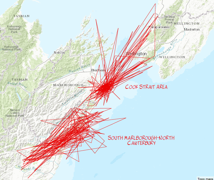
Check this out, instead of the usual icons I used "tracks"
you can see there are two distinct aftershock areas, Cook has 203 and South Marlborough-North Canterbury 183 events so far
The tracks are not in time sequence but I think it does show that there are 2 faults at play here
rightclickviewimageorwhateverittakestoseefullsize
Yes that is what I am thinking, as I tried to say in replying to TA that it is hard to tell when you feel one whether it is a 6.2 300km away or a 5.7 100km away, it seems to be determined in the length of sway. It was a bit different when we were having the aftershocks of the Cook Strait 2013 series on the first days of each 6.5 as they were all coming from approx. the same distance.
Check this out, instead of the usual icons I used "tracks"
you can see there are two distinct aftershock areas, Cook has 203 and South Marlborough-North Canterbury 183 events so far
The tracks are not in time sequence but I think it does show that there are 2 faults at play here
rightclickviewimageorwhateverittakestoseefullsize
If you are able be sure to check out the 6pm News on TVOne Live Stream in 1hr 20 minutes
www.tvnz.co.nz...
they are already previewing the incoming videos of helicopter flyovers and visits to some damaged areas
its a real mess, one house has shifted 10 metres off its foundations, the guy interviewed said the owner ran into the open field in his underwear, the one that has been showing in the pictures all day that pancaked and one person died is even worse from ground level. Wellington waterfront damaged, subsidence and the Stadium damaged somewhat.
The road between Picton and Christchurch will be closed for a long time, so many massive landslides.
I wonder if they are already preparing the Cook Strait Ferries to be able to sail direct to Lyttelton Port at Christchurch, there is a lot of freight goes between Wellington and Christchurch. In fact I ordered some roofing materials from ChCh just last week, I doubt I will see it for weeks now.
Breaking News, the Clarence River landslide blocking the river has given way
www.tvnz.co.nz...
www.tvnz.co.nz...
they are already previewing the incoming videos of helicopter flyovers and visits to some damaged areas
its a real mess, one house has shifted 10 metres off its foundations, the guy interviewed said the owner ran into the open field in his underwear, the one that has been showing in the pictures all day that pancaked and one person died is even worse from ground level. Wellington waterfront damaged, subsidence and the Stadium damaged somewhat.
The road between Picton and Christchurch will be closed for a long time, so many massive landslides.
I wonder if they are already preparing the Cook Strait Ferries to be able to sail direct to Lyttelton Port at Christchurch, there is a lot of freight goes between Wellington and Christchurch. In fact I ordered some roofing materials from ChCh just last week, I doubt I will see it for weeks now.
Breaking News, the Clarence River landslide blocking the river has given way
www.tvnz.co.nz...
edit on
1100000031731716 by muzzy because: (no reason given)
any idea how that tsunami happened muzzy? landslide, possibly? Or fault based?
a reply to: TrueAmerican
The only mention I have heard is that the shockwave came from under the land and it pushed a pulse of water out to sea.
I never really understood how land based quakes could produce a tsunami but I suppose if the land shifts enough.........
2 metres north and 1 metre down at Cape Campbell, which is the only GPS station nearby, could have been worse down by Kaikoura.
We had no sirens go off here on the west coast of the north island, apparently the 111 emergency phone system was down for the first hour. You have to get your own news under those circumstances, via cell phone if you can.
Gotta feel for the citizens of Kaikoura, they are cut off, only way in is by helicopter, no water or sewerage, not sure about power.
Raining now, that won't help things. 100km winds forecast, might blow out some highrise windows already loose.
Heres the GDACS animation and list of heights, scroll down to the bottom for the animation
link
edit on
1100000031731716 by muzzy because: (no reason given)
Full moon and at farthest apogee could have been an added trigger.
Hope it does not get worse for the people in the area.
Hope it does not get worse for the people in the area.
Woh just had another one, more typically felt like close by, waiting.........
edit: while I'm waiting for the location and mag from geonet, I just realised that I can use ATS posts to register events when I post them,
for future reference, at least within a minute or 2.
I just happened to sit down and opened the topic as that one hit.
5.7 reviewed, Cook Strait, closer than all the rest
www.geonet.org.nz...
This one felt more like a "normal" quake around here, a slight wobble, then shake like crazy for 10 seconds then wobble again for a while gradually reducing.
As it happens I was sitting in the porch on my cell phone on geonet watching the trend of more and more quakes at Seddon centred over the last hour, and came inside to the laptop to mention this, but I didn't make it.
I have a bad feeling we are going to get more up here.
edit: while I'm waiting for the location and mag from geonet, I just realised that I can use ATS posts to register events when I post them,
for future reference, at least within a minute or 2.
I just happened to sit down and opened the topic as that one hit.
edit on 1100000031831816 by muzzy because: (no reason given)
5.7 reviewed, Cook Strait, closer than all the rest
www.geonet.org.nz...
This one felt more like a "normal" quake around here, a slight wobble, then shake like crazy for 10 seconds then wobble again for a while gradually reducing.
As it happens I was sitting in the porch on my cell phone on geonet watching the trend of more and more quakes at Seddon centred over the last hour, and came inside to the laptop to mention this, but I didn't make it.
I have a bad feeling we are going to get more up here.
edit on 1100000031831816 by muzzy because: (no reason given)
further to: muzzy
2 more high 5s
Cook Strait again
2016p860287, 5.8
and
2016p860286, 5.8
one second apart!
impossible to tell they were two quakes here, but definitely felt them
starting to feel closer by the intensity of the shuddering (not swaying any more now)
www.geonet.org.nz...
or
www.geonet.org.nz...
(at the rate they are coming these will be off that page in an hour replaced with new ones)
I'm off to bed, been a long day
feel free to post any new ones
I'll only bother get up if they are over 5.7 (starting to sound like an old Californian! )
2 more high 5s
Cook Strait again
2016p860287, 5.8
and
2016p860286, 5.8
one second apart!
impossible to tell they were two quakes here, but definitely felt them
starting to feel closer by the intensity of the shuddering (not swaying any more now)
www.geonet.org.nz...
or
www.geonet.org.nz...
(at the rate they are coming these will be off that page in an hour replaced with new ones)
edit on 1100000031831816 by muzzy because: (no
reason given)
I'm off to bed, been a long day
feel free to post any new ones
I'll only bother get up if they are over 5.7 (starting to sound like an old Californian! )
edit on 1100000031831816 by muzzy because: (no
reason given)
Muzzy, after you take a break from keeping up with your earthquakes, take a look at this one...
earthquake.usgs.gov...
It just seems like it's in the middle of nowhere. Not usual. I haven't take a closer look, I'm a bit busy, but curious.
I had a quick look at the USGS page and there was some past epicenters near to the south east, but none in this exact location. I don't know how far back the map goes...
a reply to: muzzy
Hi Muzzy
After you take a look at that quake that Eric put up.
Please tell us what happened to those cows that were caught on that Island of land. Did someone rescue them.
www.abovetopsecret.com...
Those poor things must have been scared. Especially the little one.
Hi Muzzy
After you take a look at that quake that Eric put up.
Please tell us what happened to those cows that were caught on that Island of land. Did someone rescue them.
www.abovetopsecret.com...
Those poor things must have been scared. Especially the little one.
Pretty still overnight, no quakes over M5
edit: I should have said "didn't feel any ..."
data shows;
14/11/2016 10:49:57 PM NZDT, 5.01, off Kaikoura Peninsula
15/11/2016 12:16:42 AM NZDT, 5.07, Cape Campbell (Seddon)
and since I got up
15/11/2016 8:17:33 AM NZDT, 5.0, inland Kaikoura
estimated 1100 tourist stranded in Kaikoura. Kaikoura is still cut off from the rest of the country.
Reports are that they will be served crayfish that was on hand for the local restaurants.
Poor buggers. Kaikoura is the Crayfish Capital of NZ . Makes sense.
There is nothing better to eat than cooked crayfish and bread and butter.
Lobster to you Northern Hemi readers.
NZ Navy is sending HMNZS Canterbury there to evacuate those who want to leave. They might not get many who want to leave if crayfish is on the survival menu!
Local radio was on about out our water here in the NI this morning (i mentioned this yesterday) , seems widespread, dirty but not contaminated.
An inland route has opened over the Lewis and Murchison Passes, its an extra 2 hours drive. But at least it is drivable.
The Ferries won't be sailing for at least a week, the bridges at the terminals both ends have been damaged.
edit on 1100000031831816 by muzzy
because: (no reason given)
a reply to: ericblair4891
From memory there was a M6 around there a few years ago, surprised then too.
I can't recall that it led to anything on land or was prior to anything big.
From memory there was a M6 around there a few years ago, surprised then too.
I can't recall that it led to anything on land or was prior to anything big.
a reply to: crappiekat
haven't heard
I read a book about the 1848 Awatere Fault 7.5 earthquake a while back, mentioned "cattle tipped over"
FWIW there was a 7-7.3 on the Hope Fault in 1888, further west than this one was
REF:2178073
LAT/LONG: -42.6, 172.55
UTC: 1888/8/31 16:45:
tauhouanga.blogspot.co.nz...
I have a bit of updating to do on that file.
edit on 1100000031831816 by muzzy because: (no reason given)
new topics
-
Bobiverse
Fantasy & Science Fiction: 18 minutes ago -
Florida man's trip overseas ends in shock over $143,000 T-Mobile phone bill
Social Issues and Civil Unrest: 23 minutes ago -
Former Labour minister Frank Field dies aged 81
People: 2 hours ago -
SETI chief says US has no evidence for alien technology. 'And we never have'
Aliens and UFOs: 4 hours ago -
This is our Story
General Entertainment: 6 hours ago -
President BIDEN Vows to Make Americans Pay More Federal Taxes in 2025 - Political Suicide.
2024 Elections: 9 hours ago -
Ode to Artemis
General Chit Chat: 10 hours ago
top topics
-
University student disciplined after saying veganism is wrong and gender fluidity is stupid
Education and Media: 17 hours ago, 14 flags -
President BIDEN Vows to Make Americans Pay More Federal Taxes in 2025 - Political Suicide.
2024 Elections: 9 hours ago, 12 flags -
Should Biden Replace Harris With AOC On the 2024 Democrat Ticket?
2024 Elections: 15 hours ago, 6 flags -
One Flame Throwing Robot Dog for Christmas Please!
Weaponry: 13 hours ago, 6 flags -
Don't take advantage of people just because it seems easy it will backfire
Rant: 13 hours ago, 4 flags -
Ditching physical money
History: 13 hours ago, 4 flags -
SETI chief says US has no evidence for alien technology. 'And we never have'
Aliens and UFOs: 4 hours ago, 4 flags -
Former Labour minister Frank Field dies aged 81
People: 2 hours ago, 3 flags -
Ode to Artemis
General Chit Chat: 10 hours ago, 3 flags -
This is our Story
General Entertainment: 6 hours ago, 2 flags
active topics
-
President BIDEN Vows to Make Americans Pay More Federal Taxes in 2025 - Political Suicide.
2024 Elections • 26 • : network dude -
So this is what Hamas considers 'freedom fighting' ...
War On Terrorism • 249 • : Vermilion -
Russia Ukraine Update Thread - part 3
World War Three • 5725 • : BernnieJGato -
NASA Researchers Discover a Parallel Universe That Runs Backwards through Time - Alongside Us
Space Exploration • 70 • : seekshelter -
SETI chief says US has no evidence for alien technology. 'And we never have'
Aliens and UFOs • 21 • : network dude -
IDF Intel Chief Resigns Over Hamas attack
Middle East Issues • 43 • : TheWoker -
University student disciplined after saying veganism is wrong and gender fluidity is stupid
Education and Media • 44 • : confuzedcitizen -
Who guards the guards
US Political Madness • 6 • : covent -
Remember These Attacks When President Trump 2.0 Retribution-Justice Commences.
2024 Elections • 53 • : Justoneman -
Bobiverse
Fantasy & Science Fiction • 0 • : DAVID64