It looks like you're using an Ad Blocker.
Please white-list or disable AboveTopSecret.com in your ad-blocking tool.
Thank you.
Some features of ATS will be disabled while you continue to use an ad-blocker.

Quake Watch 2016
page: 53share:
a reply to: muzzy
While all that was going on NW KUMAMOTO PREF pooped another 5.2,
NIEDU20160831-1551
31/08/2016 19:46:03 JST
31/08/2016 10:46:03 UTC
32.722, 130.617
5.2 ML
951.4990TTNT
12.8km
NW KUMAMOTO PREF
that will alter the graphs a bit.
back to Japan for the day.
edit ;
first look, another 400 quakes since the end of 29/08JST, and thats just the NW Prefecture, not including the other 3 Pref. in the fault zone affected by the 7.3 there
edit on 0900000024524516 by muzzy because: (no reason given)
Scientists are investigating the possibility Friday's big shake off the East Cape may have been two earthquakes.
www.stuff.co.nz...
www.stuff.co.nz...
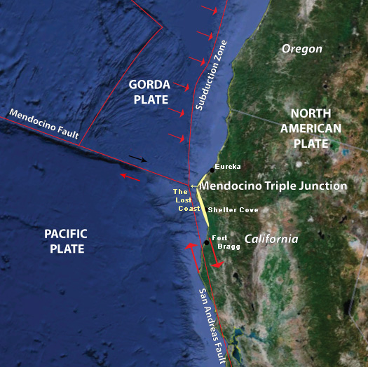
A 5.6 just struck West of Ferndale Cali..
That is really close to that main fault junction...
Only time will tell....Tick tock...Tick tock.
That is really close to that main fault junction...
Only time will tell....Tick tock...Tick tock.
Shallow
Time 2016-09-03 03:27:55 (UTC)
Location 40.421°N 125.651°W
Depth 2.2 km
On Mendocino Fault Zone
blog.mjfimages.com...
Time 2016-09-03 03:27:55 (UTC)
Location 40.421°N 125.651°W
Depth 2.2 km
On Mendocino Fault Zone
blog.mjfimages.com...
edit on 2-9-2016 by SeekingDepth because: Added Pic
I just felt the Yellowstone quake all the way from Dallas.....I'm 30 miles north anyway...
s waves wigglin' me east and west......7:06 am for 20 seconds
s waves wigglin' me east and west......7:06 am for 20 seconds
Central Oklahoma. Not on USGS yet a quake just slammed my house, still shaking (me). Giant jolt and then shaking. Everything on my dresser crashed to
the floor.
Just posted USGS
M 5.6 - 14km NW of Pawnee, Oklahoma
Time2016-09-03 12:02:44 (UTC)
Location36.429°N 96.923°W
Depth6.6 km
M 5.6 - 14km NW of Pawnee, Oklahoma
Time2016-09-03 12:02:44 (UTC)
Location36.429°N 96.923°W
Depth6.6 km
Watch Live Quake Coverage
www.news9.com...
Lots of reports of damage coming in. Felt by my sister clear up in Omaha, NE.
www.news9.com...
Lots of reports of damage coming in. Felt by my sister clear up in Omaha, NE.
On the command of Lord Muzzy of Kapitistan in the Territory of New Zealand, KCOGM (Knight Commander of the Royal and Ancient Order of Google Mappers),
KCOGW (Knight Commander of the Order of Graphing Wizards) a new version is released of the QVSData Pro program - Version 4.0.67.6.
This small change allows those who live on the underside of the world to output CSV lists of quakes in their own time zone whilst furiously applying super glue to the soles of their shoes in order to stay attached to the planet.
See my signature for the links IF the program does not automatically offer you the update.
a reply to: SeekingDepth
Seems like this one is the biggest on record for them. I believe not too far from Pawnee they had same mag a few years ago as well. I also think this fault is called the Nemaha Uplift? Need to do some research to confirm though.... can't remember.
Because of all the fracking in OK Im wondering if this takes the pressure and scare away from the New Madrid otherwise the pressure would build up and a BIG one happen along the New Madrid?
From this link.. www.zerohedge.com...
One of the comments is of question to me as well....
Seems like this one is the biggest on record for them. I believe not too far from Pawnee they had same mag a few years ago as well. I also think this fault is called the Nemaha Uplift? Need to do some research to confirm though.... can't remember.
Because of all the fracking in OK Im wondering if this takes the pressure and scare away from the New Madrid otherwise the pressure would build up and a BIG one happen along the New Madrid?
From this link.. www.zerohedge.com...
The USGS has said on its twitter account that it hopes the M5.6 quake is not a foreshock of a similar or larger quake.
One of the comments is of question to me as well....
900 miles north of the Oklahoma temblor zone is the Snake River Yellowstone formation, where there is an underground hot spot. These Oklahoma earthquakes can trigger currently unknown faultlines. About 5 days before the giant Indian Ocean earthquake and tsunami on Boxing Day in 2004, there was a much smaller earthquake off Tasmania on Thursday, December 23 that triggered the later more massive movement on the Indo-Austalian plate. If there is even a small chance that Oklahoma fracking can trigger a mantle plume in the Yellowstone caldera, the U.S. Geological Survey should recommend shutting down fracking in Oklahoma. But the empty suits at the USGS are paid off shills for the petroleum industry. So expect nothing from them.
edit on 3-9-2016 by MamaJ because: (no reason given)
USGS Retracted their 3.8 in Wyoming...??
www.emsc-csem.org...
You felt this earthquake. Tell us!
Magnitude ML 3.8
Region WYOMING
Date time 2016-09-03 12:05:27.8 UTC
Location 42.07 N ; 110.69 W
Depth 23 km
Distances 965 km N of Phoenix, United States / pop: 1,446,000 / local time: 05:05:27.8 2016-09-03
177 km NE of Salt Lake City, United States / pop: 187,000 / local time: 06:05:27.8 2016-09-03
33 km N of Kemmerer, United States / pop: 2,700 / local time: 06:05:27.8 2016-09-03
Briefly, I didn't see anything near Yellowstone that looked 3+M . California showed up on Yellowstone's squiggly lines. And, of course, there was a
mess due to Oklahoma.
Oklahoma, where the wind . no need to say much. The disaster will come if they don't stop....
NMSZ is still next door, it didn't move anywhere...
Did I write alternative lyrics with earthquakes inserted and such? I think I did.
Oh, fracking. I found out more about it's history.... It's was a mistake, the process was discover by a series of flukes mixed with greed and male testosterone.
nuff said...
The NMSZ has been active. Not spiky, but active...
edit on 3-9-2016 by ericblair4891 because: (no reason given)
a reply to: PuterMan
Yeah all info I read said 5.6 in 2011 miles away from Pawnee...but either way.... pretty big for this area. Luckily not a lot of damage and no deaths. Not sure which fault line either of them ( 2011 and todays quake) are on or if it's the same. I tried looking it u but got confused. lol
I heard Dutchinese predicted the quake in CA and in OK the night before for OK and two days prior for the CA 5.6
About 5 days before the giant Indian Ocean earthquake and tsunami on Boxing Day in 2004, there was a much smaller earthquake off Tasmania on Thursday, December 23 that triggered the later more massive movement on the Indo-Austalian plate.
I had a chuckle at that, where did you get the story?
The much smaller quake was a M8.0 !!! off Macquarie Is.
I have since 2006, when I started watching earthquakes on the internet, wondered if there was a trigger effect there, its a long way between, but sure enough they were on opposite sides of the Australian Plate.
edit on 0900000024624616 by muzzy because: (no reason given)
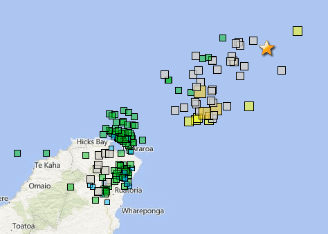
update on East Cape Ridge done a few hours ago.
here
Foreshocks: mag~1= 0 , mag1= 1 , mag2= 20 , mag3= 11 , mag4= 0, mag5= 1 , mag6= 0 , total= 33, total energy released= 5094.30 TTNT
Aftershocks of the 7.1: 0 , mag1= 35 , mag2= 270 , mag3= 193 , mag4= 64, mag5= 8 , mag6= 2 , mag7= 1, total= 573
total energy released= 703,947.437 TTNT
Quite interesting the aftershock pattern emerging in the last 138 aftershocks,
*(link edited out, Bing Maps didn't work as a link, despite being on my laptop open, see image below)
bulk of the bigger ones are the offshore ECR, as it has been for 48 hours since the 7.1
then there is a cluster "near" East Cape mostly M2's
and then a bunch of M3's on (under) land, and M2's
edit on 0900000024624616 by muzzy because: (no reason given)
a reply to: MamaJ
Hi!
I found this in SeekingDepth's news9 link:
www.news9.com...
About 37 injection wells within a 725 square mile radius of the epicenter,
were directed to start slowly shutting down!
Within 0-5 miles, by Sept.10.
Within 5-10 miles by Sept.13.
Within 10 days, because a large scale, immediate shutdown, could cause an earthquake!!!
Letter from OCC after the article.
"These instructions are mandatory & to be implemented immediately."
I hope it's not too little...too late!!!
Youngest son & his wife just moved to Texas in July.
First eq they ever felt!
He said it felt like they were on a boat!
Both of their pugs slept through it!
WOQ
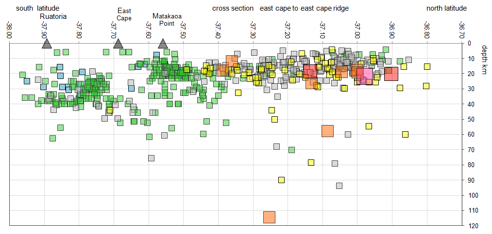
a reply to: muzzy
That map got me wondering about the depths an why it is split into 3 sections,
so I did a couple of cross section graphs, based on the ones I used back in 2014 for the Bardarbunga, Iceland eruption crisis.
I totally forgot how they were put together, took me about an hour to figure them out again. I must write up a code of instructions for myself, in case I need to do them again
I had first tried IRIS-IEB 3D Viewer but they don't have many of these earthquakes featured to make it look as good as my graphs.
heres one of the cross sections
rightclickviewimage for full size
edit on 0900000024624616 by muzzy because: (no reason given)
new topics
-
University of Texas Instantly Shuts Down Anti Israel Protests
Education and Media: 1 hours ago -
Any one suspicious of fever promotions events, major investor Goldman Sachs card only.
The Gray Area: 3 hours ago -
God's Righteousness is Greater than Our Wrath
Religion, Faith, And Theology: 7 hours ago -
Electrical tricks for saving money
Education and Media: 10 hours ago
top topics
-
VP's Secret Service agent brawls with other agents at Andrews
Mainstream News: 12 hours ago, 10 flags -
Cats Used as Live Bait to Train Ferocious Pitbulls in Illegal NYC Dogfighting
Social Issues and Civil Unrest: 16 hours ago, 8 flags -
Nearly 70% Of Americans Want Talks To End War In Ukraine
Political Issues: 13 hours ago, 4 flags -
Electrical tricks for saving money
Education and Media: 10 hours ago, 4 flags -
Sunak spinning the sickness figures
Other Current Events: 12 hours ago, 3 flags -
Late Night with the Devil - a really good unusual modern horror film.
Movies: 14 hours ago, 2 flags -
Any one suspicious of fever promotions events, major investor Goldman Sachs card only.
The Gray Area: 3 hours ago, 2 flags -
God's Righteousness is Greater than Our Wrath
Religion, Faith, And Theology: 7 hours ago, 0 flags -
University of Texas Instantly Shuts Down Anti Israel Protests
Education and Media: 1 hours ago, 0 flags
active topics
-
President BIDEN Vows to Make Americans Pay More Federal Taxes in 2025 - Political Suicide.
2024 Elections • 137 • : CriticalStinker -
I think this life means something.
Philosophy and Metaphysics • 59 • : seekshelter -
Late Night with the Devil - a really good unusual modern horror film.
Movies • 5 • : chiefsmom -
Nearly 70% Of Americans Want Talks To End War In Ukraine
Political Issues • 33 • : andy06shake -
Sunak spinning the sickness figures
Other Current Events • 11 • : McUrnsalso -
Any one suspicious of fever promotions events, major investor Goldman Sachs card only.
The Gray Area • 6 • : ImagoDei -
University of Texas Instantly Shuts Down Anti Israel Protests
Education and Media • 1 • : PorkChop96 -
Reason of the Existence
The Gray Area • 20 • : belkide -
Black mirror, what happened.
Television • 20 • : seekshelter -
God's Righteousness is Greater than Our Wrath
Religion, Faith, And Theology • 25 • : andy06shake