It looks like you're using an Ad Blocker.
Please white-list or disable AboveTopSecret.com in your ad-blocking tool.
Thank you.
Some features of ATS will be disabled while you continue to use an ad-blocker.

Quake Watch 2016
page: 5share:
Puterman, I think it's about time you wrote a scientific paper on the earthquakes that occur in the middle of the Atlantic Ocean. Those reoccurring
earthquakes associated with Reykjanes Ridge.
earthquake.usgs.gov...
Just to check our hypothesis, (the one where you and I agree the weather is responsible) I looked at he weather satellites and sure enough, a massive storm just passed over the area. Hmmm. And Iceleand was acting up a bit earlier. Maybe. No. Let's stick the obvious thing due to observation. When big storms pass over Reykjanes Ridge, the pressure change - or sumtin' like dat, stresses the faults and we get a reaction. Again I come back to my bigger idea, water is once again, the catalyst.
I only suggest the paper because you said at one time you were trying to match the weather to the earthquakes. I have watched and they follow the pattern. And, they are even seasonal as you once stated. I'd have enough evidence by now, but I am so very lazy.

Unusual location
Public ID 2016p041491
Intensity moderate
Universal Time January 16 2016, 8:26:41
NZ Daylight Time Sat, Jan 16 2016, 9:26:41 pm
Depth 3 km
Magnitude 3.7
Location 85 km south-east of Balclutha (off the Catlin Coast, SI, NZ)
Latitude, Longitude -46.97, 170.09
www.geonet.org.nz...
Do get some rare ones sometimes offshore further north near Dunedin
edit on 01000000151516 by muzzy because: (no reason given)
Cuba is wanting to get into the mix.
Here is the lastest one that happen around 2:45am CST.
earthquake.usgs.gov...
Here is the lastest one that happen around 2:45am CST.
earthquake.usgs.gov...
a reply to: crappiekat
earthquake.usgs.gov...
We have some interesting activity going on in Cuba area.
Here is some more Info from someone who Knows his stuff.
www.abovetopsecret.com...
earthquake.usgs.gov...
We have some interesting activity going on in Cuba area.
Here is some more Info from someone who Knows his stuff.
www.abovetopsecret.com...
edit on 17-1-2016 by crappiekat because: (no reason given)
edit on 17-1-2016 by crappiekat because: (no reason given)
a reply to: ericblair4891
I will get round to it one day, but just at the moment I have other things to take care of.
Scientific paper? Me? Mmm don't know about that, but I tell you what it would be published in the NCGT Journal possiblly.
I will get round to it one day, but just at the moment I have other things to take care of.
Scientific paper? Me? Mmm don't know about that, but I tell you what it would be published in the NCGT Journal possiblly.
2016-01-21 01:13:13.0 CST
37.7 101.6
10
Ms6.4
天然地震
青海海北州门源县
(Qinghai Haibei door Source County)
data.earthquake.cn...
GFZ say 5.9Mw geofon.gfz-potsdam.de...
37.7 101.6
10
Ms6.4
天然地震
青海海北州门源县
(Qinghai Haibei door Source County)
data.earthquake.cn...
GFZ say 5.9Mw geofon.gfz-potsdam.de...
further to: muzzy
I made an error of sorts in following the N Philippine Basin M5.6 earthquake aftershocks, missing 90 of them in the series, now causing the total number of to all but double.
It wasn't until I clicked on one of the icons on the daiy Japan map in the group that I realized SHIKOKU BASIN (another JMA region) is also part of the series, the border of the two regions must run through the center of the series, I had only been processing "N PHILIPPINE BASIN"
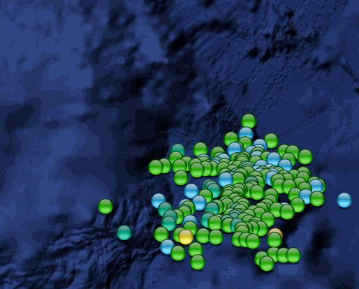
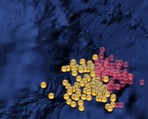
So I have updated the page with those and changed the name to N Philippine/Shikoku Basins M5.6 a/s 5-19Jan 2016
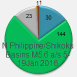
Energy wise the brunt is being bourne by the Philippine Basin in the west, the largest of the 90 quakes in the Shikoku Basin to the east so far are 3.5 and 3.3
the maps screenshots below show;
1 by magnitude (now including the Shikoku ones too)
2. the two regions (Orange is N Philippine Basin, Magenta is Shikoku Basin)
I made an error of sorts in following the N Philippine Basin M5.6 earthquake aftershocks, missing 90 of them in the series, now causing the total number of to all but double.
It wasn't until I clicked on one of the icons on the daiy Japan map in the group that I realized SHIKOKU BASIN (another JMA region) is also part of the series, the border of the two regions must run through the center of the series, I had only been processing "N PHILIPPINE BASIN"
So I have updated the page with those and changed the name to N Philippine/Shikoku Basins M5.6 a/s 5-19Jan 2016
Energy wise the brunt is being bourne by the Philippine Basin in the west, the largest of the 90 quakes in the Shikoku Basin to the east so far are 3.5 and 3.3
the maps screenshots below show;
1 by magnitude (now including the Shikoku ones too)
2. the two regions (Orange is N Philippine Basin, Magenta is Shikoku Basin)
further to: muzzy
another screenshot from that series, showing the latest aftershocks (3 days old!), trending towards the underlying Plate, Shikoku Basin side
light grey icons are all the aftershocks, the star 5.6 main shock, and the coloured ones are the latest data, coloured by magnitude
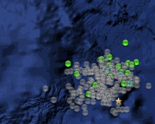
Also, IRIS WIlber3 for some reason still haven't done the energy readings for the main shock,
but GCMT have come out with 5.9Mw and NIEC at 5.8MB
ds.iris.edu...
another screenshot from that series, showing the latest aftershocks (3 days old!), trending towards the underlying Plate, Shikoku Basin side
light grey icons are all the aftershocks, the star 5.6 main shock, and the coloured ones are the latest data, coloured by magnitude
Also, IRIS WIlber3 for some reason still haven't done the energy readings for the main shock,
but GCMT have come out with 5.9Mw and NIEC at 5.8MB
ds.iris.edu...
edit on 01000000202016 by muzzy because: (no reason given)
a reply to: muzzy
I have also made some adjustments to the NR AMAMI-OSHIMA IS aftershock series parameters. The "NR AMAMI-OSHIMA IS" JMA area is huge and was starting to include micro quakes that were 280km+ away, and clearly not part of the M5.4 aftershock series. So I have trimmed the coverage area down to a 30km radius. Not doing so was skewing the numbers, making the 5.4 aftershocks look even more out of proportion when compared to the N Philippine Basin series, which had a bigger main shock.
This change has taken 44 events off the latest data list, incl. losing a M4.0 (near Kikai-shima Is) and and a M3.8
NR AMAMI-OSHIMA IS @10.4days
M6.9 - 235km SW of Tomatlan, Mexico
earthquake.usgs.gov...
Time
2016-01-21 18:07:00 (UTC)
2016-01-21 10:07:00 (UTC-08:00) in your timezone
Times in other timezones
Nearby Cities
235km (146mi) SW of Tomatlan, Mexico
265km (165mi) WSW of Cihuatlan, Mexico
286km (178mi) W of Manzanillo, Mexico
290km (180mi) SW of Puerto Vallarta, Mexico
833km (518mi) W of Mexico City, Mexico
a reply to: dreamfox1
Potsdam have it significantly lower.
2016-01-21 18:06:58, 18.800, -107.040, 6.1, 10.0 Off Coast Of Jalisco. Mexico
Potsdam have it significantly lower.
2016-01-21 18:06:58, 18.800, -107.040, 6.1, 10.0 Off Coast Of Jalisco. Mexico
Live Quakecam acting very strange now just after that large quake. Pressure must be extremely high.
abc7.com...
abc7.com...
M3.0 - 8km SSE of Yucca Valley, California
earthquake.usgs.gov...
Time
2016-01-21 18:13:41 (UTC)
2016-01-21 10:13:41 (UTC-08:00) in your timezone
Times in other timezones
Nearby Cities
8km (5mi) SSE of Yucca Valley, California
12km (7mi) SW of Joshua Tree, California
14km (9mi) NE of Desert Hot Springs, California
17km (11mi) E of Morongo Valley, California
28km (17mi) NNE of Palm Springs, California
a reply to: PuterMan
Just found this: Tsunami in Washington State. www.youtube.com...
thought it belonged here
Just found this: Tsunami in Washington State. www.youtube.com...
thought it belonged here
edit on 21-1-2016 by GrantedBail because: (no reason given)
edit on 21-1-2016 by GrantedBail because:
(no reason given)
edit on 21-1-2016 by GrantedBail because: (no reason given)
www.tsunami.gov...
There is no tsunami threat involved with the earthquake that happened off shore in Mexico.
This information has the earthquake magnitude at 6.9. It was downgraded to a 6.6.
earthquake.usgs.gov...
There is no tsunami threat involved with the earthquake that happened off shore in Mexico.
This information has the earthquake magnitude at 6.9. It was downgraded to a 6.6.
earthquake.usgs.gov...
edit on 21-1-2016 by crappiekat because: to
add
edit on 21-1-2016 by crappiekat because: (no reason given)
a reply to: GrantedBail
Hi Granted.
Did alittle more digging, and found this article. This event happened last weekend according to the article.
They say the tide was coming in, and a rogue wave came in too.
www.king5.com...
Hi Granted.
Did alittle more digging, and found this article. This event happened last weekend according to the article.
They say the tide was coming in, and a rogue wave came in too.
www.king5.com...
new topics
-
I hate dreaming
Rant: 9 minutes ago -
Is the origin for the Eye of Horus the pineal gland?
General Conspiracies: 1 hours ago -
Man sets himself on fire outside Donald Trump trial
Mainstream News: 2 hours ago -
Biden says little kids flip him the bird all the time.
2024 Elections: 2 hours ago -
The Democrats Take Control the House - Look what happened while you were sleeping
US Political Madness: 2 hours ago -
Sheetz facing racial discrimination lawsuit for considering criminal history in hiring
Social Issues and Civil Unrest: 2 hours ago -
In an Historic First, In N Out Burger Permanently Closes a Location
Mainstream News: 4 hours ago -
MH370 Again....
Disaster Conspiracies: 5 hours ago -
Are you ready for the return of Jesus Christ? Have you been cleansed by His blood?
Religion, Faith, And Theology: 7 hours ago -
Chronological time line of open source information
History: 8 hours ago
top topics
-
In an Historic First, In N Out Burger Permanently Closes a Location
Mainstream News: 4 hours ago, 14 flags -
The Democrats Take Control the House - Look what happened while you were sleeping
US Political Madness: 2 hours ago, 9 flags -
Thousands Of Young Ukrainian Men Trying To Flee The Country To Avoid Conscription And The War
Other Current Events: 15 hours ago, 8 flags -
A man of the people
Medical Issues & Conspiracies: 10 hours ago, 8 flags -
Man sets himself on fire outside Donald Trump trial
Mainstream News: 2 hours ago, 7 flags -
Biden says little kids flip him the bird all the time.
2024 Elections: 2 hours ago, 6 flags -
4 plans of US elites to defeat Russia
New World Order: 11 hours ago, 4 flags -
Are you ready for the return of Jesus Christ? Have you been cleansed by His blood?
Religion, Faith, And Theology: 7 hours ago, 3 flags -
Is the origin for the Eye of Horus the pineal gland?
General Conspiracies: 1 hours ago, 3 flags -
Sheetz facing racial discrimination lawsuit for considering criminal history in hiring
Social Issues and Civil Unrest: 2 hours ago, 3 flags
active topics
-
Is the origin for the Eye of Horus the pineal gland?
General Conspiracies • 4 • : JoelSnape -
Man sets himself on fire outside Donald Trump trial
Mainstream News • 18 • : nugget1 -
Biden says little kids flip him the bird all the time.
2024 Elections • 9 • : FlyersFan -
12 jurors selected in Trump criminal trial
US Political Madness • 87 • : ImagoDei -
Fossils in Greece Suggest Human Ancestors Evolved in Europe, Not Africa
Origins and Creationism • 72 • : Xtrozero -
I hate dreaming
Rant • 0 • : FlyersFan -
MH370 Again....
Disaster Conspiracies • 8 • : Lazy88 -
Do we live in a simulation similar to The Matrix 1999?
ATS Skunk Works • 27 • : purplemer -
Thousands Of Young Ukrainian Men Trying To Flee The Country To Avoid Conscription And The War
Other Current Events • 27 • : Xtrozero -
911 emergency lines are DOWN across multiple states
Breaking Alternative News • 8 • : nugget1