It looks like you're using an Ad Blocker.
Please white-list or disable AboveTopSecret.com in your ad-blocking tool.
Thank you.
Some features of ATS will be disabled while you continue to use an ad-blocker.

Quake Watch 2016
page: 13share:
I was just looking at these quakes.
For anyone interested, here is alittle history on this area.
en.wikipedia.org...
On March 26, 1872 an estimated mm7.4 to 7.9 earthquake that leveled the area.
52 of the 59 homes in the area were destroyed.
Sorry I am have computer problems.
For anyone interested, here is alittle history on this area.
en.wikipedia.org...
On March 26, 1872 an estimated mm7.4 to 7.9 earthquake that leveled the area.
edit on 16-2-2016 by crappiekat because: to add. Getting forgetful
52 of the 59 homes in the area were destroyed.
Sorry I am have computer problems.
edit on 16-2-2016 by crappiekat because: (no reason given)
edit on 16-2-2016 by crappiekat
because: (no reason given)
a reply to: crappiekat
That 1872 earthquake was a doosey. Thanks for linking that information.
Some great news out of Oklahoma.
The Oklahoma Corporation Commission has made the emergency decision to cut volumes of frack wastewater injection 40% over 5200 square miles in the NW area of the state. This will impact 245 wells, and will be phased in over 2 months. It comes in direct response to the Mag 5.1 quake Saturday, near Fairview, OK.
Link
Geofon (GFZ) are usually pretty reliable, but I wonder about this one
GFZ - 2016-02-16 23:48:36, 55.76°S, 125.10°W, 10, 5.0M, Southern East Pacific Rise
LDEO - 2016-2-16 23:48:40, -56.25, -124.75, 33.0, 6.1Ms, SOUTHERN EAST PACIFIC RISE
quite a big trace on SNZO, as well as the Antarctica stations, definitely more than a 5.0
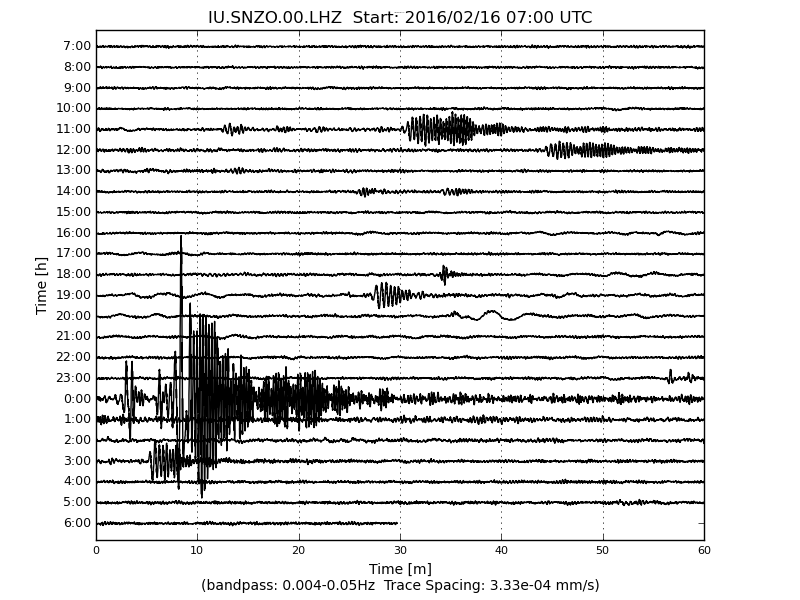
GFZ - 2016-02-16 23:48:36, 55.76°S, 125.10°W, 10, 5.0M, Southern East Pacific Rise
LDEO - 2016-2-16 23:48:40, -56.25, -124.75, 33.0, 6.1Ms, SOUTHERN EAST PACIFIC RISE
quite a big trace on SNZO, as well as the Antarctica stations, definitely more than a 5.0
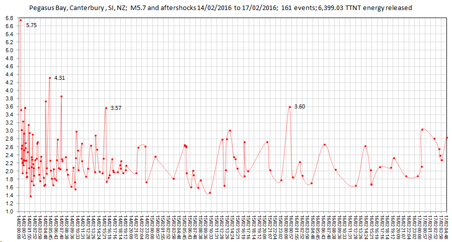
I did a Timeline Graph for Pegasus Bay 5.7, nothing startling
rightclickviewimageforfullsize
rightclickviewimageforfullsize
edit on 02000000474716 by muzzy because: (no reason given)
a reply to: muzzy
They fixed it
2016-02-16 23:48:35, 6.1Mw, 55.84°S, 124.41°W, 22, Southern East Pacific Rise
geofon.gfz-potsdam.de...
They fixed it
2016-02-16 23:48:35, 6.1Mw, 55.84°S, 124.41°W, 22, Southern East Pacific Rise
geofon.gfz-potsdam.de...
a reply to: muzzy
For those who weren't around or didn't follow it, this 5.7 is an aftershock of the Darfield M7.1 of 03/09/2010 NZST
It is number 52 in the 5+ aftershocks series, shown below as a gold star.
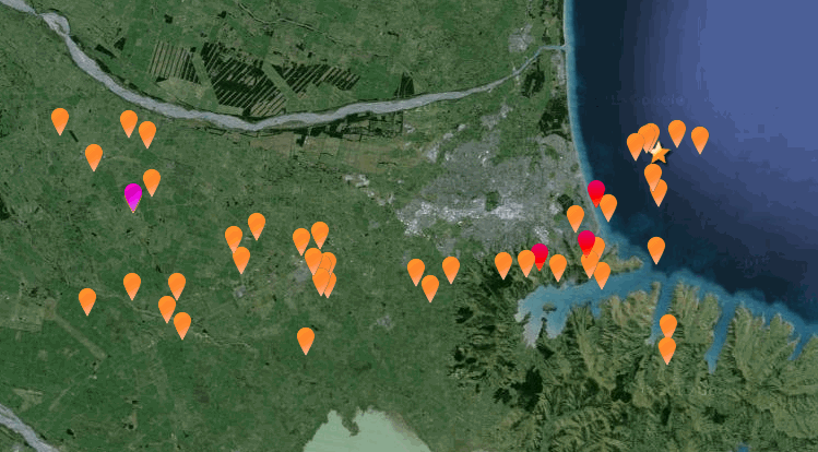
On the Bing map version (with the numbers in sequence) you can see how the 5+ aftershocks tracked to the East.
Darfield Canterbury 5+ interactive map
or NZ Topo version on nzeq2016.blogspot.co.nz...
I altered the original KMZ file on Google Earth to make those maps, as it appears I have deleted all the data that I created to do the Canterbury Series on Wordpress, I can't find the Excel CSV files anywhere. But I do have all the KMZ files stored on Dropbox. I think last year I decided to start from scratch (after Google dumped Classic Maps) with fresh updated data from Geonet and downloaded a file of all of 2011 and 2012 NZ quakes, as that is all I have in the 2011 folder now, yet to be processed.
For those who weren't around or didn't follow it, this 5.7 is an aftershock of the Darfield M7.1 of 03/09/2010 NZST
It is number 52 in the 5+ aftershocks series, shown below as a gold star.
On the Bing map version (with the numbers in sequence) you can see how the 5+ aftershocks tracked to the East.
Darfield Canterbury 5+ interactive map
or NZ Topo version on nzeq2016.blogspot.co.nz...
I altered the original KMZ file on Google Earth to make those maps, as it appears I have deleted all the data that I created to do the Canterbury Series on Wordpress, I can't find the Excel CSV files anywhere. But I do have all the KMZ files stored on Dropbox. I think last year I decided to start from scratch (after Google dumped Classic Maps) with fresh updated data from Geonet and downloaded a file of all of 2011 and 2012 NZ quakes, as that is all I have in the 2011 folder now, yet to be processed.
edit on 02000000474716 by muzzy because: (no reason given)
Taiwan again, east of that big one earlier in the month
Time(local), Mag, Depth, Lat, Long, Location
02/18 09:56, 3.6, 7.1 , 23.06N 120.88E, 43.6 km NW of Taitung County
02/18 09:32, 3.8, 6.5 , 23.04N 120.87E, 42.8 km NW of Taitung County
02/18 09:20, 3.9, 7.0 , 23.02N 120.87E, 41.1 km NW of Taitung County
02/18 09:18, 4.7, 5.0 , 23.02N 120.90E, 38.9 km NW of Taitung County
02/18 09:12, 3.9, 4.4 , 23.02N 120.88E, 40.4 km NW of Taitung County
02/18 09:09, 5.1, 16.7 , 23.00N 120.90E, 37.4 km NW of Taitung County
02/17 16:14, 3.7, 5.3 , 23.02N 120.89E, 39.8 km NW of Taitung County
02/17 15:07, 4.2, 2.9 , 23.03N 120.89E, 40.4 km NW of Taitung
www.cwb.gov.tw...
edit on 02000000474716 by muzzy because: (no reason given)
Where did everyone go?
This occurred a little while ago off the coast of Japan close to where the large one happened in 2011.
M 5.1 - 112km ESE of Namie, Japan
Time 2016-02-19 13:13:52 UTC
Location 37.221°N 142.222°E
Depth 20.2 km
This was preceded to the South by:
M 4.5 - 6km WSW of Yachimata, Japan
Time 2016-02-19 01:50:18 UTC
Location 35.635°N 140.243°E
Depth 53.2 km
and then to the North by:
M 4.5 - 142km E of Yamada, Japan
Time 2016-02-19 08:13:27 UTC
Location 39.252°N 143.579°E
Depth 29.4 km
Source
What do you make of it?
Is there something bigger coming?
Bishop
originally posted by: Bishop2199
What do you make of it?
Is there something bigger coming?
Bishop
Could always be on the cards, but this looks more like an aftershock of 2011 (just the same as the 14th Feb Pegasus Bay 5.7 was an aftershock of the 2010/2011 Canterbury Series in New Zealand).
edit on 02000000494916 by muzzy because: (no reason given)
Speaking of the Pegasus Bay quake
Geo Australia has finalized at 6.0Mwp !!, this is the same as the last M6 there on 23/12/2011 at New Brighton.
www.ga.gov.au...
USGS and IRIS aren't being very helpful, sticking to mb and Mww, and not showing Mwp or Me results.
ds.iris.edu...
Geo Australia has finalized at 6.0Mwp !!, this is the same as the last M6 there on 23/12/2011 at New Brighton.
www.ga.gov.au...
USGS and IRIS aren't being very helpful, sticking to mb and Mww, and not showing Mwp or Me results.
ds.iris.edu...
a reply to: Bishop2199
location, location, location
a year, or 5 years, is but a blink in the millenia of the life of Earth
location, location, location
a year, or 5 years, is but a blink in the millenia of the life of Earth
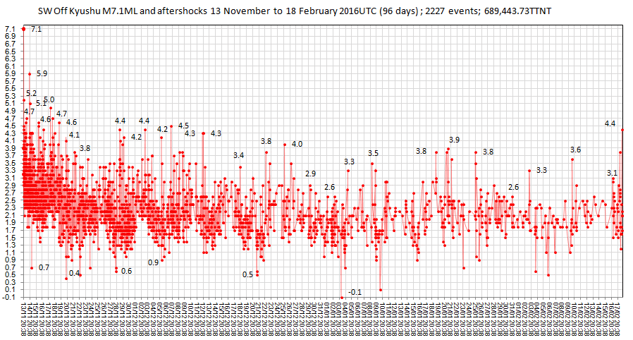
The SW off Kyushu M7.1 of 13th Nov 2015 continues to pop out aftershocks after 13 weeks, mostly below 3.9 now, about a half dozen or less a day over
the last few weeks, but with a bit of a resurgence on the 17th UTC with 25 new events in 24hrs incl. a M4.4, so I'll keep updating that one (now @
2227 events)
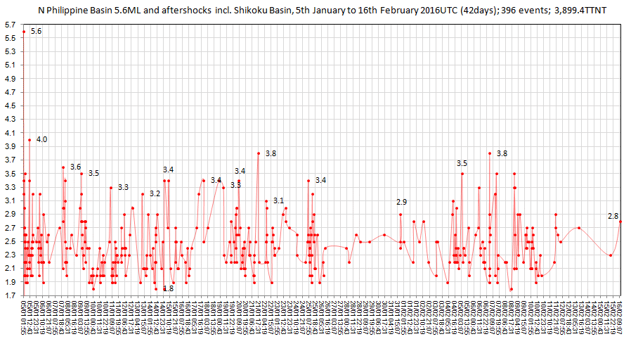
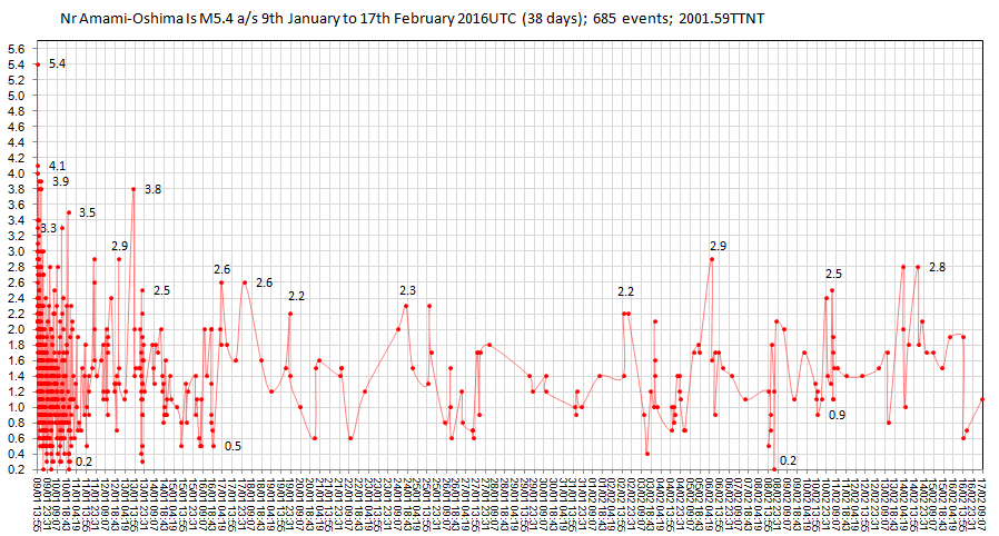
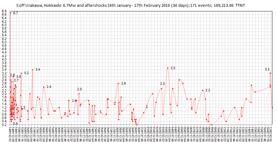
The other Japan area series I have been tracking on japanearthquakes this year, such as N Philippine/Shikoku Basins M5.6 of 5th Jan, Nr Amami Oshima Is M5.4 of 9th Jan, and S of Urakawa M6.7 of 14th Jan seem to have come to their end, tapering down to just one or two small quakes a day.
I'll leave those where they are for now and move on, there is a new "hot spot" NW Off Okinawajima Is, which started on the 14th Feb UTC.
Now @ 161 events after 4 days, not a biggie as far as energy released goes, it started out low magnitude, with the biggest (so far ) of M4.2.
I don't usually do graphs for under M5, but this one looks interesting.
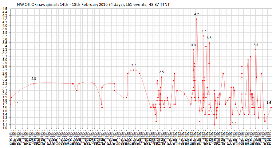
All the above (except the Urakawa quake, are due to the PhilippinePlate on the move (and the Taiwan 6.4Mw of 5th Feb)
page
interactive Bing map
The other Japan area series I have been tracking on japanearthquakes this year, such as N Philippine/Shikoku Basins M5.6 of 5th Jan, Nr Amami Oshima Is M5.4 of 9th Jan, and S of Urakawa M6.7 of 14th Jan seem to have come to their end, tapering down to just one or two small quakes a day.
I'll leave those where they are for now and move on, there is a new "hot spot" NW Off Okinawajima Is, which started on the 14th Feb UTC.
Now @ 161 events after 4 days, not a biggie as far as energy released goes, it started out low magnitude, with the biggest (so far ) of M4.2.
I don't usually do graphs for under M5, but this one looks interesting.
All the above (except the Urakawa quake, are due to the PhilippinePlate on the move (and the Taiwan 6.4Mw of 5th Feb)
page
interactive Bing map
originally posted by: muzzy
a reply to: Bishop2199
location, location, location
a year, or 5 years, is but a blink in the millenia of the life of Earth
OK. That makes sense. So if a smaller earthquake occurs in the same general vicinity of a previous larger earthquake, it will be considered an aftershock regardless of time between quakes. At what point, do we label it a separate event? If it is larger than a previous event in the same vicinity, do we then label the previous event as a foreshock of the larger?
Bishop
a reply to: Bishop2199
Thats where it gets fuzzy.
The recorded history of earthquakes only goes back to 314BC, but there were obviously earthquakes long before that.
The way I look at it is that all earthquakes are aftershocks.Way back millions of years ago I bet a mag 9 would be sniffed at as a pifflingly small quake, but there were no humans around to do the sniffing, not even dinosaurs!
Who is to say that the biggest quakes recorded in New Zealand was the M8.2 in 1855. Perhaps (likely) there were more of those, if not bigger ones going back a thousand years before then. This is how mountains are built. I worked on a property on the cliffs above the east shore of Wellington harbour where the entire cliff face was layered at a 45 degree angle 100 metres up with sea shells in some of the layers, that didn't happen from a little M8 thats for sure, even a M9 lifts 10's of metres not 100's. The whole mass of land had been lifted up out of the sea at a 45 degree angle, at some stage.
I take the stand that take any big quake, draw a 50 or 100km circle around it, any quakes within the circle after that are aftershocks, until another bigger one comes along.
Also you can throw in "quiet periods", such as when there are NO further earthquakes AT ALL for several years inside that circle, ie. the crust is "locked". Anything that pops up eventually could be considered a "new" event. Sumatra might fit into this scenario, it has been a long time since there has been a M7 along the Aceh-Nias coast, enough time that I consider that Fault "locked" (and primed?). And that's only 12 years.
Activity also shifts over time, back to 314 BC, the Middle East was wracked by M7's and M8's for hundreds of years, now it is quiet.
Chile is a complicated example to fit the premise, because it has had so many M8's. The circle around Chile quakes would have to be much less size.
Yes in hindsight when the bigger one comes along the previous ones would be considered foreshock's.
there was a series of 7x M6+'s along NZ's South lsland West coast (Fiordland) that ran from 1989 and eventually led to the biggest so far, the 7.8Mw Dusky Sound quake of 2009. So theoretically they were all foreshocks of the 7.8. The oldest recorded quake in this area was a M7.0 in 1938 then a gap to a M6 in1943, then a gap to 1989. The area involved was bigger though, which brings in "triggering". That's another theory for another day.
edit on 02000000494916 by muzzy because: (no reason given)
My son just made fun of me. I am in an excitable mood. I've been thinking to myself that we have lots and lots of earthquakes. I am seeing clustering
and although no one areas is over active, there is wide spread shaking. I said something aloud to myself, something like," my spidey earthquake senses
are tingling". He then said, you mean, "your spidey, earthquake-volcano obsessive senses are tingling."
I said, "Yes."
sigh, freakin' kid....
I said, "Yes."
sigh, freakin' kid....
Oh, I didn't mean say much about the series of earthquakes in the mid-Atlantic, but since I was looking at the maps of the cyclone that hit those poor
folks on Fiji, I decided to see what was up near the Atlantic earthquakes and found a storm right near the swarm. Again, we have no main shock etc. We
have a series of seven earthquakes. The lowest being 4.8 M and the highest being 5.1M.
There are earthquakes about 200 km away Fiji. Not saying nothing.
There are earthquakes about 200 km away Fiji. Not saying nothing.
further to: muzzy
a reply to: Bishop2199
Of course you get some aftershocks who have their own aftershocks, like in Japan 2011 there were side-swarms of aftershocks from M6's and M5's all over Honshu in the months afterwards.
And just yesterday afternoon in Christchurch a 3.4 produced 5 aftershocks of it's own. The only way you can see this is because they were a bit away from the recent Mag 5.7 that set this set off again. Although 26km west of the 5.7 and main bunch of aftershocks, these all fit within the area of the 2010/2011 aftershock "Fault", so are all considered aftershocks of the 2010 M7.1 of 3rd Sept.
I really need to get the Canterbury series converted to NZ Topo maps (Googles maps are now blank) as it is a good reference series for questions about aftershocks.
a reply to: Bishop2199
Of course you get some aftershocks who have their own aftershocks, like in Japan 2011 there were side-swarms of aftershocks from M6's and M5's all over Honshu in the months afterwards.
And just yesterday afternoon in Christchurch a 3.4 produced 5 aftershocks of it's own. The only way you can see this is because they were a bit away from the recent Mag 5.7 that set this set off again. Although 26km west of the 5.7 and main bunch of aftershocks, these all fit within the area of the 2010/2011 aftershock "Fault", so are all considered aftershocks of the 2010 M7.1 of 3rd Sept.
edit on 02000000505016 by muzzy because: (no reason given)
I really need to get the Canterbury series converted to NZ Topo maps (Googles maps are now blank) as it is a good reference series for questions about aftershocks.
edit on 02000000505016 by muzzy because: (no reason given)
new topics
-
WF Killer Patents & Secret Science Vol. 1 | Free Energy & Anti-Gravity Cover-Ups
General Conspiracies: 29 minutes ago -
Hurt my hip; should I go see a Doctor
General Chit Chat: 1 hours ago -
Israel attacking Iran again.
Middle East Issues: 2 hours ago -
Michigan school district cancels lesson on gender identity and pronouns after backlash
Education and Media: 2 hours ago -
When an Angel gets his or her wings
Religion, Faith, And Theology: 3 hours ago -
Comparing the theology of Paul and Hebrews
Religion, Faith, And Theology: 4 hours ago -
Pentagon acknowledges secret UFO project, the Kona Blue program | Vargas Reports
Aliens and UFOs: 5 hours ago -
Boston Dynamics say Farewell to Atlas
Science & Technology: 5 hours ago -
I hate dreaming
Rant: 5 hours ago -
Man sets himself on fire outside Donald Trump trial
Mainstream News: 7 hours ago
top topics
-
The Democrats Take Control the House - Look what happened while you were sleeping
US Political Madness: 8 hours ago, 18 flags -
In an Historic First, In N Out Burger Permanently Closes a Location
Mainstream News: 10 hours ago, 16 flags -
A man of the people
Medical Issues & Conspiracies: 16 hours ago, 11 flags -
Biden says little kids flip him the bird all the time.
Politicians & People: 8 hours ago, 8 flags -
Man sets himself on fire outside Donald Trump trial
Mainstream News: 7 hours ago, 7 flags -
Pentagon acknowledges secret UFO project, the Kona Blue program | Vargas Reports
Aliens and UFOs: 5 hours ago, 6 flags -
Michigan school district cancels lesson on gender identity and pronouns after backlash
Education and Media: 2 hours ago, 5 flags -
Israel attacking Iran again.
Middle East Issues: 2 hours ago, 5 flags -
4 plans of US elites to defeat Russia
New World Order: 17 hours ago, 4 flags -
Boston Dynamics say Farewell to Atlas
Science & Technology: 5 hours ago, 4 flags
active topics
-
Hurt my hip; should I go see a Doctor
General Chit Chat • 11 • : TheLieWeLive -
Sheetz facing racial discrimination lawsuit for considering criminal history in hiring
Social Issues and Civil Unrest • 7 • : Caver78 -
Silent Moments --In Memory of Beloved Member TDDA
Short Stories • 48 • : Encia22 -
MULTIPLE SKYMASTER MESSAGES GOING OUT
World War Three • 52 • : cherokeetroy -
Israel attacking Iran again.
Middle East Issues • 22 • : Boomer1947 -
WF Killer Patents & Secret Science Vol. 1 | Free Energy & Anti-Gravity Cover-Ups
General Conspiracies • 1 • : WakeofPoseidon -
The Democrats Take Control the House - Look what happened while you were sleeping
US Political Madness • 67 • : WeMustCare -
Thousands Of Young Ukrainian Men Trying To Flee The Country To Avoid Conscription And The War
Other Current Events • 53 • : ghandalf -
Boston Dynamics say Farewell to Atlas
Science & Technology • 5 • : Caver78 -
Biden says little kids flip him the bird all the time.
Politicians & People • 16 • : stelth2